Hayden Lake, Idaho

Last updated
Hayden Lake, Idaho
Kootenai County Idaho Incorporated and Unincorporated areas Hayden Lake Highlighted 1636460.svg
Location of Hayden Lake in Kootenai County, Idaho.
Usa edcp location map.svg
Red pog.svg
Hayden Lake, Idaho
Location in the United States
Coordinates: 47°45′53″N116°45′21″W / 47.76472°N 116.75583°W / 47.76472; -116.75583 Coordinates: 47°45′53″N116°45′21″W / 47.76472°N 116.75583°W / 47.76472; -116.75583
Country United States
State Idaho
County Kootenai
Area
[1]
  Total0.78 sq mi (2.03 km2)
  Land0.61 sq mi (1.58 km2)
  Water0.17 sq mi (0.45 km2)
Elevation
2,287 ft (697 m)
Population
 (2010) [2]
  Total574
  Estimate 
(2019) [3]
623
  Density1,019.64/sq mi (393.64/km2)
Time zone UTC-8 (Pacific (PST))
  Summer (DST) UTC-7 (PDT)
ZIP code
83835
Area code 208
FIPS code 16-36460
GNIS feature ID0396631

Hayden Lake is a city in Kootenai County, Idaho, United States. Located in the northern portion of the state, it is considered a suburb of the city of Coeur d'Alene. Its population was 574 at the 2010 census. The city was named after the nearby Lake Hayden, which is now more commonly also known as Hayden Lake, after the city.

Contents

The city is located around the Hayden Lake Country Club and a small portion of the northern part of the lake. Most of the lake is surrounded by the larger city of Hayden. The shores of the lake are filled with summer cabins to large historical and modern mansions and the historic Hayden Lake Country Club lies at the center of the community.

Geography

Aerial view of the lake from east by southeast, 2013 Aerial - Hayden Lake, ID 05 - white balanced (9967837134).jpg
Aerial view of the lake from east by southeast, 2013

Hayden Lake is located at 47°45′53″N116°45′21″W / 47.76472°N 116.75583°W / 47.76472; -116.75583 (47.764720, -116.755931). [4]

According to the United States Census Bureau, the city has a total area of 0.68 square miles (1.76 km2), of which 0.59 square miles (1.53 km2) is land and 0.09 square miles (0.23 km2) is water. [5]

Geology

Hayden Lake, like Lake Coeur d'Alene and other lakes surrounding the Spokane Valley and Rathdrum Prairie, was formed by the Missoula Floods, most recently 12,000 to 15,000 years ago. The Purcell Lobe of the Cordilleran Ice Sheet flowed south from Canada, carving the basin of present-day Lake Pend Oreille and damming the Clark Fork river. The impounded river repeatedly filled to form Glacial Lake Missoula and broke through the ice dam, resulting in massive floods that filled the Rathdrum Prairie area with sand, gravel, and boulders. [6] Large eddy bars formed downstream from bedrock obstructions, thereby damming tributary valleys and creating lakes.

History

The north end of the lake Tomthespud 5835.jpg
The north end of the lake

The Coeur D’Alene tribe territory centered around what is now Hayden Lake and nearby Lake Coeur d'Alene, gathering plants, including abundant huckleberries, fish and wildlife. The first white man to visit the area was Father DeSmet while serving as a missionary to the Coeur d’Alene Indians. While visiting, he named it Lake DeNuf and recorded several stories told by the local tribe about the lake and the surrounding area. [7] [8]

Hayden Lake's natural beauty attracted several wealthy people in the early 1900s. The F. Lewis Clark Mansion was built in 1910, and was the most expensive home in Idaho at the time. In 1914, Lewis mysteriously disappeared and was never seen or heard from again. [9] In 1907, the Hayden Lake Country Club became a gathering place for many area socialites, such as Bing Crosby. A railway expansion made travel easy from nearby Spokane. HLCC opened the first 18-hole golf course in the state of Idaho in 1912. [10]

From the 1970s until 2001, the neo-Nazi Aryan Nations had its headquarters in a 20-acre (8.1 ha) compound in Kootenai County near Hayden Lake. In September 2000, the Southern Poverty Law Center won a $6.3 million judgment against the Aryan Nations from an Idaho jury, who awarded punitive and compensatory damages to Victoria Keenan and her son, Jason, who were attacked by Aryan Nations guards in 1999. [11] Bullets struck the Keenans' car several times, then the car crashed and an Aryan member held the Keenans at gunpoint. [12] As a result of the judgment, Richard Butler turned the compound over to the Keenans, who then sold the property to a philanthropist who subsequently donated it to North Idaho College, which designated the land as a "peace park". [13] [14]

Demographics

Historical population
CensusPop.Note
1950 39
1960 247533.3%
1970 2605.3%
1980 2735.0%
1990 33823.8%
2000 49446.2%
2010 57416.2%
2019 (est.)623 [3] 8.5%
U.S. Decennial Census [15]

2010 census

At the 2010 census there were 574 people in 256 households, including 188 families, in the city. The population density was 972.9 inhabitants per square mile (375.6/km2). There were 369 housing units at an average density of 625.4 per square mile (241.5/km2). The racial makeup of the city was 97.6% White, 0.2% Native American, 0.5% Asian, and 1.7% from two or more races. Hispanic or Latino of any race were 3.0%. [2]

Of the 256 households 19.9% had children under the age of 18 living with them, 66.4% were married couples living together, 2.7% had a female householder with no husband present, 4.3% had a male householder with no wife present, and 26.6% were non-families. 22.7% of households were one person and 13.3% were one person aged 65 or older. The average household size was 2.24 and the average family size was 2.61.

The median age was 54.2 years. 17.8% of residents were under the age of 18; 3.7% were between the ages of 18 and 24; 14.5% were from 25 to 44; 34.9% were from 45 to 64; and 29.3% were 65 or older. The gender makeup of the city was 51.2% male and 48.8% female.

2000 census

At the 2000 census there were 494 people in 208 households, including 164 families, in the city. The population density was 1,281.9 inhabitants per square mile (494.9/km2). There were 307 housing units at an average density of 796.6 per square mile (307.6/km2). The racial makeup of the city was 99.60% White, 0.20% Native American and 0.20% Asian. Hispanic or Latino of any race were 0.81%. [16] 19.6% were of German, 14.4% English, 8.6% Irish, 6.1% Norwegian, 6.1% Scottish and 5.9% Swedish ancestry according to Census 2000. 97.6% spoke English and 2.4% Spanish as their first language.

Of the 208 households 23.6% had children under the age of 18 living with them, 74.0% were married couples living together, 4.3% had a female householder with no husband present, and 20.7% were non-families. 18.3% of households were one person and 9.1% were one person aged 65 or older. The average household size was 2.38 and the average family size was 2.65.

The age distribution was 19.2% under the age of 18, 3.4% from 18 to 24, 20.2% from 25 to 44, 35.4% from 45 to 64, and 21.7% 65 or older. The median age was 49 years. For every 100 females, there were 99.2 males. For every 100 females age 18 and over, there were 95.6 males.

The median household income was $65,893 and the median family income was $67,143. Males had a median income of $50,250 versus $30,804 for females. The per capita income for the city was $31,834. About 7.7% of families and 8.3% of the population were below the poverty line, including 11.7% of those under age 18 and 4.3% of those age 65 or over.

Notable people

Related Research Articles

<span class="mw-page-title-main">Shoshone County, Idaho</span> County in Idaho, United States

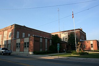
Shoshone County is a county in the U.S. state of Idaho. As of the 2020 census, the population was 13,169. The largest city is Kellogg. The county was established in 1864, named for the Native American Shoshone tribe.

<span class="mw-page-title-main">Kootenai County, Idaho</span> County in Idaho, United States

Kootenai County is located in the U.S. state of Idaho. In 2020, the United States Census Bureau estimated the county's population at 171,362, making it the third-most populous county in Idaho and by far the largest in North Idaho, the county accounting for 45.4% of the region's total population. The county seat and largest city is Coeur d'Alene. The county was established in 1864 and named after the Kootenai tribe.

<span class="mw-page-title-main">Bonner County, Idaho</span> County in Idaho, United States

Bonner County is a county in the northern part of the U.S. state of Idaho. As of the 2020 census, the population was 47,110. The county seat and largest city is Sandpoint. Partitioned from Kootenai County and established in 1907, it was named for Edwin L. Bonner, a ferry operator.

<span class="mw-page-title-main">Benewah County, Idaho</span> County in Idaho, United States

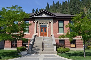
Benewah County is a county located in the northwest part of the U.S. state of Idaho. As of the 2020 United States Census the county had a population of 9,530. The county seat and largest city is St. Maries, which has some area inside the Coeur d'Alene Reservation.

<span class="mw-page-title-main">Post Falls, Idaho</span> City in Idaho, United States

Post Falls is a city in Kootenai County, Idaho, between Coeur d'Alene and Spokane, Washington. It is a suburb of Coeur d'Alene, to the east, and a bedroom community to Spokane, to the west. The population was 38,485 at the time of the 2020 census, up from 17,247 in the 2000 census, making it Idaho's tenth-largest city.

<span class="mw-page-title-main">Plummer, Idaho</span> City in Idaho, United States

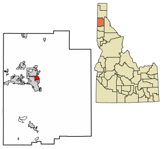
Plummer is a city in Benewah County, Idaho, United States. The population was 1,044 at the 2010 census, up from 990 in 2000. It is the largest city within the Coeur d'Alene Reservation, and is accessed by U.S. Route 95, the state's primary north–south highway.

<span class="mw-page-title-main">St. Maries, Idaho</span> City in Idaho, United States

St. Maries is a city in north central Idaho, the largest in rural Benewah County and its county seat. Its population was 2,402 at the 2010 census, down from 2,652 in 2000.

<span class="mw-page-title-main">Clark Fork, Idaho</span> City in Idaho, United States

Clark Fork is a small town in Bonner County, Idaho. The population was 536 at the time of the 2010 census.

<span class="mw-page-title-main">Sandpoint, Idaho</span> City in Idaho, United States

Sandpoint is the largest city in, and the county seat of, Bonner County, Idaho. Its population was 8,639 at the 2020 census.

<span class="mw-page-title-main">Rigby, Idaho</span> City in Idaho, United States

Rigby is a city in and the county seat of Jefferson County, Idaho, United States. The population was 3,945 at the 2010 census, up from 2,998 in 2000.

<span class="mw-page-title-main">Athol, Idaho</span> City in Idaho, United States

Athol is a city in Kootenai County, Idaho, United States. The population was 692 at the 2010 census, up from 676 in 2000. It is part of the Coeur d'Alene Metropolitan Statistical Area, which includes the entire county.

<span class="mw-page-title-main">Coeur d'Alene, Idaho</span> City in Idaho, United States

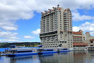
Coeur d'Alene is a city and the county seat of Kootenai County, Idaho, United States. It is the largest city in North Idaho and the principal city of the Coeur d'Alene Metropolitan Statistical Area. At the 2020 census the city's population was 54,628. Coeur d'Alene is a satellite city of Spokane, which is located about thirty miles (50 km) to the west in the state of Washington. The two cities are the key components of the Spokane–Coeur d'Alene Combined Statistical Area, of which Coeur d'Alene is the third-largest city. The city is situated on the north shore of the 25-mile (40 km) long Lake Coeur d'Alene and to the west of the Coeur d'Alene Mountains. Locally, Coeur d'Alene is known as the "Lake City," or simply called by its initials, "CDA."

<span class="mw-page-title-main">Dalton Gardens, Idaho</span> City in Kootenai County, Idaho, United States

Dalton Gardens is a city in Kootenai County, Idaho, United States. It is considered a suburb of Coeur d'Alene and borders the city to the north and east. The city of Dalton Gardens is also part of the larger Spokane-Coeur d'Alene Combined Metropolitan Statistical Area which encompasses Kootenai County, Idaho. The population of Dalton Gardens was 2,335 at the time of the 2010 census.

<span class="mw-page-title-main">Harrison, Idaho</span> City in Idaho, United States

Harrison is a city in Kootenai County, Idaho, United States. The population was 203 at the 2010 census. Harrison is located on the eastern shore of Lake Coeur d'Alene, immediately south of where the Coeur d'Alene River flows into the lake.

<span class="mw-page-title-main">Hauser, Idaho</span> City in Idaho, United States

Hauser is a city in Kootenai County, Idaho, United States. The population was 678 at the 2010 census. The city is located on the southern end of Hauser Lake.

<span class="mw-page-title-main">Hayden, Idaho</span> City in Idaho, United States

Hayden is a city in Kootenai County, Idaho, United States. Located in the northern portion of the state, it is a suburb of nearby Coeur d'Alene and its population was 15,570 at the 2020 census.

<span class="mw-page-title-main">Spirit Lake, Idaho</span> City in Idaho, United States

Spirit Lake is a city in Kootenai County, Idaho. The population was 1,945 at the time of the 2010 census, up from 1,376 in 2000. It is part of the Coeur d'Alene Metropolitan Statistical Area, which includes the entire county.

<span class="mw-page-title-main">Stateline, Idaho</span> City in Idaho, United States

Stateline, officially the City of State Line, and historically known as State Line Village, is a city in Kootenai County, Idaho, United States, and is both the easternmost suburb of Spokane, Washington and the westernmost suburb of Coeur d'Alene, Idaho. The population was 38 at the 2010 census. The city is known for the adult services it provides which attract business from nearby Spokane and Coeur d'Alene. The unincorporated community of Spokane Bridge, Washington is located across the Spokane River to the southwest.

<span class="mw-page-title-main">Worley, Idaho</span> City in Idaho, United States

Worley is a city in southwestern Kootenai County, Idaho, United States. The population was 257 at the 2010 census, up from 223 in 2000. The city is within the Coeur d'Alene Indian Reservation.

<span class="mw-page-title-main">Missoula metropolitan area</span>

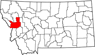
The Missoula metropolitan statistical area is located in the west-central portion of the state, the 2020 United States Census put the MSA's population at 117,922, making it the 2nd largest metropolitan statistical area in Montana. July 1, 2011 Census estimates put the Missoula Metropolitan Area population at 110,138 making it the second Metropolitan area in Montana to surpass 100,000 people, behind Billings and ahead of Bozeman.

References

  1. "2019 U.S. Gazetteer Files". United States Census Bureau. Retrieved July 9, 2020.
  2. 1 2 "U.S. Census website". United States Census Bureau . Retrieved 2012-12-18.
  3. 1 2 "Population and Housing Unit Estimates". United States Census Bureau. May 24, 2020. Retrieved May 27, 2020.
  4. "US Gazetteer files: 2010, 2000, and 1990". United States Census Bureau. 2011-02-12. Retrieved 2011-04-23.
  5. "US Gazetteer files 2010". United States Census Bureau . Retrieved 2012-12-18.
  6. Breckenridge, Roy M. (May 1993). Glacial Lake Missoula and the Spokane Floods (PDF) (Report). GeoNote. Vol. 26. Idaho Geological Survey.
  7. "Hayden was booming at turn of century". ruralnorthwest.com. Retrieved 2021-12-07.
  8. Singletary, Robert (1995). Kootenai Chronicles: A History of Kootenai County Volume 1. Coeur D'Alene, ID: Museum of North Idaho. p. 8. ISBN   0-9643647-4-3.
  9. Archived 2011-09-27 at the Wayback Machine | Clarkhouse.com History
  10. Archived 2011-09-03 at the Wayback Machine | Country Club History
  11. "Attorney Morris Dees pioneer in using 'damage litigation' to fight hate groups". CNN. September 8, 2000. Archived from the original on 2007-10-08. Retrieved 2007-08-17.
  12. "Keenan v. Aryan Nations". Southern Poverty Law Center. 2000. Retrieved 2007-08-17.
  13. Wakin, Daniel J. (September 9, 2004). "Richard G. Butler, 86, Dies; Founder of the Aryan Nations". New York Times . Retrieved 2007-08-22.
  14. Verhovek, Sam Howe (16 February 2002). "With Aryans Gone, Town Seeks New Life". New York Times . Retrieved 30 January 2011.
  15. "Census of Population and Housing". Census.gov. Retrieved June 4, 2015.
  16. "U.S. Census website". United States Census Bureau . Retrieved 2008-01-31.