
Télécom Paris is a French public institution for higher education and engineering research. Located in Palaiseau, it is also a member of the Institut Polytechnique de Paris and the Institut Mines-Télécom. In 2021 it was the sixth highest ranked French university in the World University Rankings, and the 7th best small university worldwide. In the QS Ranking, Télécom Paris is the 64th best university worldwide in Computer Science.
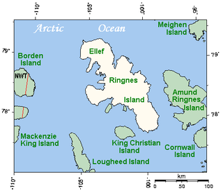
Ellef Ringnes Island is an uninhabited island and one of the Sverdrup Islands in the Qikiqtaaluk Region, Nunavut, Canada. A member of the Queen Elizabeth Islands and Arctic Archipelago, it is located in the Arctic Ocean, east of Borden Island, and west of Amund Ringnes Island. It has an area of 11,295 km2 (4,361 sq mi), making it the 69th largest island in the world and Canada's 16th largest island. Its highest mount is 260 m (850 ft).
Political geography is concerned with the study of both the spatially uneven outcomes of political processes and the ways in which political processes are themselves affected by spatial structures. Conventionally, for the purposes of analysis, political geography adopts a three-scale structure with the study of the state at the centre, the study of international relations above it, and the study of localities below it. The primary concerns of the subdiscipline can be summarized as the inter-relationships between people, state, and territory.

Yves Lacoste is a French geographer, known for his political commitment and contributions to geopolitics. Born in Rabat, Morocco, the son of a geologist, Jean Lacoste, and a librarian, he spent his childhood in the city before continuing his secondary education at the Lycée Lakanal in Sceaux (Seine) and his higher education at the Sorbonne.
Jacques Ancel was a French geographer and geopolitician. He was the author of several books, including Peoples and Nations of Balkans: political geography (1926) and Geopolitics (1936).

Paul Vidal de La Blache was a French geographer. He is considered to be the founder of modern French geography and also the founder of the French School of Geopolitics. He conceived the idea of genre de vie, which is the belief that the lifestyle of a particular region reflects the economic, social, ideological and psychological identities imprinted on the landscape.

The École Pour l'Informatique et les Techniques Avancées, more commonly known as EPITA, is a private French grande école specialized in the field of computer science and software engineering created in 1984 by Patrice Dumoucel. It is a private engineering school, member of IONIS Education Group since 1994, accredited by the Commission des titres d'ingénieur (CTI) to deliver the French Diplôme d'Ingénieur, and based at Le Kremlin-Bicêtre south of Paris.

Bernard Miège is a French media theorist and academic administrator. He is Emeritus Professor of Communication and Information Science at Stendhal University in Grenoble. He was educated at Paris University, both in political studies and in economics. He has a Ph.D. in economics (Paris) and another Ph.D. in humanities (Bordeaux). He is the author of fifteen works in the following fields: the cultural industries, the introduction of the technologies of information and communication in the society and in the organisations, and the analysis of the theories of communication.
TELECOM Lille (formerly ENIC) was a French public Grande école. In 2017, TELECOM Lille merges with the École des Mines Douai and becomes École des Mines-Télécom de Lille-Douai.

The University of Technology of Troyes is a French university, in the academy of Reims. The UTT is part of the network of the three universities of technology, found by the University of Technology of Compiègne. Inspired by the American University of Pennsylvania in Philadelphia, these three universities are a French mixture between the universities of this country and its schools of engineers .UTT is ranked in the top 10 engineering schools 2017 in France by Usine Nouvelle.

Jacques Bertin was a French cartographer and theorist, known from his book Sémiologie Graphique, published in 1967. This monumental work, based on his experience as a cartographer and geographer, represents the first and widest intent to provide a theoretical foundation to Information Visualization, with his most lasting contribution being his set of visual variables that can be used to construct map symbols and other graphical techniques one of then being the Bertin Projection, an innovative map projection type.
Dominique Varry is a French historian of books and professor at École nationale supérieure des sciences de l'information et des bibliothèques, part of the University of Lyon.

Jean-Bernard Racine was a professor of geography at the Institute of Geography, Faculty of Geosciences and Environment of the University of Lausanne (UNIL) and at HEC Lausanne Business School. Racine received his first PhD in geography from the University of Aix-en-Provence (1965) and his State PhD in geography (1973) from the University of Nice. Jean-Bernard Bernard was a professor at the University of Sherbrooke between 1965 and 1969, and at the University of Ottawa from 1969 to 1973.
Denis Retaillé was a Professor of Geography at the University of Bordeaux III and the Director of the CNRS ADES Research Unit, UMR 5186. Professor Retaillé holds a PhD in Geography from the University of Rouen (1983) dedicated to the study of the Nigerien region of Koutous, and an Habilitation from the Paris-Sorbonne University (1993) dedicated to the study of space in the Sahel. From 1993 to 2008, Denis Retaillé was a Professor of Geography at the University of Rouen, France.
Jacqueline Beaujeu-Garnier was a French geographer. She was president of the Société de Géographie from 1983 to 1995 and led the scientific publication L'Information géographique. With Philippe Pinchemel she founded the geographical periodical Hommes et Terres du Nord in 1963.

Béatrice Galinon-Mélénec is a French semiotician. She is professor emeritus of communication studies, specializing in the fields of anthropology of communication and the analysis of the non-verbal dimension of interpersonal communication situations. Her approach to the interpretation of signs is based on the new wave of semiotics, known as anthroposemiotics where embodied semiotics takes a central position.

Maximilien Sorre, known as Max Sorre, was a French geographer whose work was mainly in the areas of biological and human geography.

France université numérique (FUN) is the French national platform to promote the use of massive open online courses (MOOCs).
Marcel Bayard (1895-1956) was a French mathematician and telecommunications engineer. He made pioneering contributions to the telecommunications theory in the 1930s. As Chief Engineer of French telecommunications after World War II, he supervised and modernized the French telecommunications system.

Pierre Musso is a French philosopher and historian of technology.
