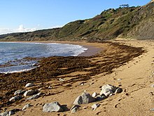
The coast, also known as the coastline, shoreline or seashore, is defined as the area where land meets the ocean, or as a line that forms the boundary between the land and the coastline. Shores are influenced by the topography of the surrounding landscape, as well as by water induced erosion, such as waves. The geological composition of rock and soil dictates the type of shore which is created. The Earth has around 620,000 kilometres (390,000 mi) of coastline. Coasts are important zones in natural ecosystems, often home to a wide range of biodiversity. On land, they harbor important ecosystems such as freshwater or estuarine wetlands, which are important for bird populations and other terrestrial animals. In wave-protected areas they harbor saltmarshes, mangroves or seagrasses, all of which can provide nursery habitat for finfish, shellfish, and other aquatic species. Rocky shores are usually found along exposed coasts and provide habitat for a wide range of sessile animals and various kinds of seaweeds. In physical oceanography, a shore is the wider fringe that is geologically modified by the action of the body of water past and present, while the beach is at the edge of the shore, representing the intertidal zone where there is one. Along tropical coasts with clear, nutrient-poor water, coral reefs can often be found between depths of 1–50 meters.

Tides are the rise and fall of sea levels caused by the combined effects of the gravitational forces exerted by the Moon and are also caused by the Earth and Moon orbiting one another.
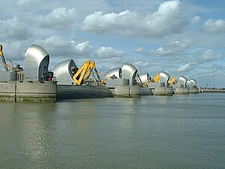
The Thames Barrier is a retractable barrier system built to protect the floodplain of most of Greater London from exceptionally high tides and storm surges moving up from the North Sea. It has been operational since 1982. When needed, it is closed (raised) during high tide; at low tide, it can be opened to restore the river's flow towards the sea. Built about 2 miles east of the Isle of Dogs, its northern bank is in Silvertown in the London Borough of Newham and its southern bank is in the New Charlton area of the Royal Borough of Greenwich.

A storm surge, storm flood, tidal surge, or storm tide is a coastal flood or tsunami-like phenomenon of rising water commonly associated with low-pressure weather systems, such as cyclones. It is measured as the rise in water level above the normal tidal level, and does not include waves.
Riparian water rights is a system for allocating water among those who possess land along its path. It has its origins in English common law. Riparian water rights exist in many jurisdictions with a common law heritage, such as Canada, Australia, New Zealand, and states in the eastern United States.

A body of water, such as a river, canal or lake, is navigable if it is deep, wide and calm enough for a water vessel to pass safely. Navigability is also referred to in the broader context of a body of water having sufficient under keel clearance for a vessel.
The National Flood Insurance Program (NFIP) is a program created by the Congress of the United States in 1968 through the National Flood Insurance Act of 1968. The NFIP has two purposes: to share the risk of flood losses through flood insurance and to reduce flood damages by restricting floodplain development. The program enables property owners in participating communities to purchase insurance protection, administered by the government, against losses from flooding, and requires flood insurance for all loans or lines of credit that are secured by existing buildings, manufactured homes, or buildings under construction, that are located in the Special Flood Hazard Area in a community that participates in the NFIP. U.S. Congress limits the availability of National Flood Insurance to communities that adopt adequate land use and control measures with effective enforcement provisions to reduce flood damages by restricting development in areas exposed to flooding.

A flood barrier, surge barrier or storm surge barrier is a specific type of floodgate, designed to prevent a storm surge or spring tide from flooding the protected area behind the barrier. A surge barrier is almost always part of a larger flood protection system consisting of floodwalls, levees, and other constructions and natural geographical features.

The intertidal zone or foreshore is the area above water level at low tide and underwater at high tide: in other words, the part of the littoral zone within the tidal range. This area can include several types of habitats with various species of life, such as seastars, sea urchins, and many species of coral with regional differences in biodiversity. Sometimes it is referred to as the littoral zone or seashore, although those can be defined as a wider region.

The public trust doctrine is the principle that the sovereign holds in trust for public use some resources such as shoreline between the high and low tide lines, regardless of private property ownership.

River engineering is a discipline of civil engineering which studies human intervention in the course, characteristics, or flow of a river with the intention of producing some defined benefit. People have intervened in the natural course and behaviour of rivers since before recorded history—to manage the water resources, to protect against flooding, or to make passage along or across rivers easier. Since the Yuan Dynasty and Ancient Roman times, rivers have been used as a source of hydropower. From the late 20th century, the practice of river engineering has responded to environmental concerns broader than immediate human benefit. Some river engineering projects have focused exclusively on the restoration or protection of natural characteristics and habitats.
Navigable servitude is a doctrine in United States constitutional law that gives the federal government the right to regulate navigable waterways as an extension of the Commerce Clause in Article I, Section 8 of the constitution. It is also sometimes called federal navigational servitude.
Robert Gillespie James is a senior United States district judge of the United States District Court for the Western District of Louisiana, and was one of the judges involved in a 2006 water rights legal case, Normal Parm v. Sheriff Mark Shumate.
Water quality laws govern the protection of water resources for human health and the environment. Water quality laws are legal standards or requirements governing water quality, that is, the concentrations of water pollutants in some regulated volume of water. Such standards are generally expressed as levels of a specific water pollutants that are deemed acceptable in the water volume, and are generally designed relative to the water's intended use - whether for human consumption, industrial or domestic use, recreation, or as aquatic habitat. Additionally, these laws provide regulations on the alteration of the chemical, physical, radiological, and biological characteristics of water resources. Regulatory efforts may include identifying and categorizing water pollutants, dictating acceptable pollutant concentrations in water resources, and limiting pollutant discharges from effluent sources. Regulatory areas include sewage treatment and disposal, industrial and agricultural waste water management, and control of surface runoff from construction sites and urban environments. Water quality laws provides the foundation for regulations in water standards, monitoring, required inspections and permits, and enforcement. These laws may be modified to meet current needs and priorities.
This glossary of geography terms is a list of definitions of terms and concepts used in geography and related fields, including Earth science, oceanography, cartography, and human geography, as well as those describing spatial dimension, topographical features, natural resources, and the collection, analysis, and visualization of geographic data. It is split across two articles:

Coastal flooding occurs when dry and low-lying land is submerged (flooded) by seawater. The range of a coastal flooding is a result of the elevation of floodwater that penetrates the inland which is controlled by the topography of the coastal land exposed to flooding. The seawater can flood the land via several different paths: direct flooding, overtopping of a barrier, or breaching of a barrier. Coastal flooding is largely a natural event. Due to the effects of climate change and an increase in the population living in coastal areas, the damage caused by coastal flood events has intensified and more people are being affected.

At a flat coast or flat shoreline, the land descends gradually into the sea. Flat coasts can be formed either as a result of the sea advancing into gently sloping terrain or through the abrasion of loose rock. They may be basically divided into two parallel strips: the shoreface and the beach.

The December 1992 nor'easter produced record high tides and snowfall across the northeastern United States. It developed as a low pressure area on December 10 over Virginia, and for two days it remained over the Mid-Atlantic states before moving offshore. In Maryland, the snowfall unofficially reached 48 in (1,200 mm); if verified, the total would have been the highest in the state's history. About 120,000 people were left without power in the state due to high winds. Along the Maryland coast, the storm was less severe than the Perfect Storm in the previous year, although the strongest portion of the storm remained over New Jersey for several days. In the state, winds reached 80 mph (130 km/h) in Cape May, and tides peaked at 10.4 ft (3.2 m) in Perth Amboy. The combination of high tides and 25 ft (7.6 m) waves caused the most significant flooding in the state since the Ash Wednesday Storm of 1962. Several highways and portions of the New York City Subway and Port Authority Trans-Hudson systems were closed due to the storm. Throughout New Jersey, the nor'easter damaged about 3,200 homes and caused an estimated $750 million in damage (1992 USD).
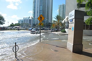
Tidal flooding, also known as sunny day flooding or nuisance flooding, is the temporary inundation of low-lying areas, especially streets, during exceptionally high tide events, such as at full and new moons. The highest tides of the year may be known as the king tide, with the month varying by location. These kinds of floods tend not to be a high risk to property or human safety, but further stress coastal infrastructure in low lying areas.