
Papua New Guinea, officially the Independent State of Papua New Guinea, is a country in Oceania that comprises the eastern half of the island of New Guinea and its offshore islands in Melanesia. Its capital, located along its southeastern coast, is Port Moresby. The country is the world's third largest island country, with an area of 462,840 km2 (178,700 sq mi).
Lae is the capital of Morobe Province and is the second-largest city in Papua New Guinea. It is located near the delta of the Markham River and at the start of the Highlands Highway, which is the main land transport corridor between the Highlands Region and the coast. Lae is the largest cargo port of the country and is the industrial hub of Papua New Guinea. The city is known as the Garden City and home of the University of Technology.

For administrative purposes, Papua New Guinea is divided into administrative divisions called provinces. There are 22 provincial-level divisions, which include 20 provinces, the Autonomous Region of Bougainville, and the National Capital District of Port Moresby.
Enga is one of the provinces in Papua New Guinea (PNG). It is located in the north most region of the highlands of PNG, having been divided from the Western Highlands to become a separate province when the provinces were created at the time of independence in 1975. The people of Enga are called Engans—they are a majority ethnic group—speaking one language in all its five districts: approximately 500,000 people. A small minority of Engans' land on the eastern side of the region remained in the Western Highlands, their territory being accessible by road from Mount Hagen but not directly from elsewhere in Enga territory.

Western New Guinea, also known as Papua, Indonesian New Guinea, Indonesian Papua, is the western, Indonesian half of the island of New Guinea. Since the island is alternatively named as Papua, the region is also called West Papua.

Chimbu, more frequently spelled Simbu, is a province in the Highlands Region of Papua New Guinea. The province has an area of 6,112 km2 and a population of 376,473. The capital of the province is Kundiawa. Mount Wilhelm, the tallest mountain in Papua New Guinea is on the border of Eastern part of Simbu and the Western part of Madang Province.

Gulf Province is a province of Papua New Guinea located on the southern coast. The provincial capital is Kerema. The 34,472 km2 province is dominated by mountains, lowland river deltas, and grassland flood plains. In Gulf Province, the Kikori, Turama, Purari, and Vailala rivers meet the Papuan Gulf. The province has the second-smallest population of all the provinces of Papua New Guinea with 106,898 inhabitants. The province shares land borders with Western Province to the west, Southern Highlands, Chimbu, and Eastern Highlands to the north, Morobe Province to the east, and Central Province to the southeast.

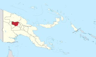
Western Highlands is a province of Papua New Guinea. The provincial capital is Mount Hagen. The province covers an area of 4,299 km2, and there are 362,850 inhabitants, making the Western Highlands the most densely populated province. Tea and coffee are grown in the Western Highlands.

Eastern Highlands is a highlands province of Papua New Guinea. The provincial capital is Goroka. The province covers an area of 11,157 km², and has a population of 579,825. The province shares a common administrative boundary with Madang Province to the north, Morobe Province to the east, Gulf Province to the south, and Simbu Province to the west. The province is the home of the Asaro mud mask that is displayed at shows and festivals within the province and in the country. The province is reachable by air, including Goroka Airport, and road transport, including the main Highlands Highway.

Southern Highlands is a province in Papua New Guinea. Its provincial capital is the town of Mendi. According to Papua New Guinea's national 2011 census, the total population of Southern Highlands is 515,511 spread across 15,089 square kilometers (5,826 sq mi).

Papua New Guinea is divided into four regions, which are its broadest administrative divisions of Papua New Guinea. While the 22 provincial-level divisions are the primary administrative divisions of PNG, the regions are quite significant in daily life, as they are often the basis for organisation of government services, corporate operations, sporting competitions, and even the machinations of politics.
The Papuans are one of four major cultural groups of Papua New Guinea. The majority of the population lives in rural areas. In isolated areas there remains a handful of the giant communal structures that previously housed the whole male population, with a circling cluster of huts for the women. The Papuan people are Melanesian people composed of at least 240 different peoples, each with its own language and culture. Sago is the staple food of the Papuan supplemented with hunting, fishing and small gardens.

Papua New Guinea has 326 local-level governments (LLGs) comprising 6,112 wards as of 2018.
This page is a list of districts of Papua New Guinea.
For administrative purposes, Papua New Guinea (PNG) is divided into administrative divisions called regions and provinces. Papua New Guinea is divided into four regions and 22 province-level divisions: 20 provinces plus the autonomous region (Bougainville) and the National Capital District.

The New Guinea Highlands, also known as the Central Range or Central Cordillera, is a long chain of mountain ranges on the island of New Guinea, including the island's tallest peak, Puncak Jaya, Indonesia, 16,024 ft (4,884 m), the highest mountain in Oceania. The range is home to many intermountain river valleys, many of which support thriving agricultural communities. The highlands run generally east-west the length of the island, which is divided politically between Indonesia in the west and Papua New Guinea in the east.

New Guinea is the world's second-largest island, with an area of 785,753 km2 (303,381 sq mi). Located in Melanesia in the southwestern Pacific Ocean, the island is separated from Australia by the 150-kilometre wide Torres Strait, though both landmasses lie on the same continental shelf. Numerous smaller islands are located to the west and east.

Cannabis in Papua New Guinea is illegal, but the nation is a significant producer and consumer of cannabis. Cannabis is sometimes called spak brus in local parlance.
Events in the year 2021 in Papua New Guinea.
On 11 September 2022, an earthquake of moment magnitude 7.6–7.7 struck Papua New Guinea, in the northern part of Morobe Province. The normal faulting earthquake occurred with a hypocenter depth of 116.0 km (72.1 mi) beneath the Finisterre Range. A maximum perceived Modified Mercalli intensity of VIII (Severe) was estimated. Shaking was widely felt across the country and even in neighbouring Indonesia. At least 21 people died and 42 were injured, mostly due to landslides.
