History of Markham, Ontario

Last updated

St. John's Lutheran Cemetery in Markham dates to the 1820s, decades after European settlement of the area. St Johns Lutheran Cemetery, Markham, ON 01.jpg
St. John's Lutheran Cemetery in Markham dates to the 1820s, decades after European settlement of the area.

The history of Markham, Ontario dates back several millennia. What would become Markham, Ontario was home to First Nations long before European settlement. Seasonal settlements were found from 900 BC to 1650, but traces of these first residence were buried before the area was farmed. [1]

Contents

18th century

What would become western end of Markham was acquired in the Toronto Purchase in 1787 and eastern parts under the Rouge Tract Claim or Gunshot Treaty (Johnson-Butler Purchase) 1788 covering most of Markham, as well as Stouffville and Scarborough.

When Upper and Lower Canada were established in 1791, Colonel John Graves Simcoe was appointed the first Lieutenant-Governor of Upper Canada. Simcoe named the township of Markham, north of the town of York (now Toronto), after his friend William Markham, the Archbishop of York.

Markham Township was originally surveyed in 1793–94, but not until 1801 was the township divided into 10 concession roads (now named as Street, Avenue, Road or Line) running north and south, with six sideroads running east–west (now numbered avenues or named Drive or Road). Many of these concession and sideroads in Markham still exist today. Eventually, the boundaries of Markham occupied the area, as follows:

In 1794, William Berczy led 64 German families from New York State to Markham Township, an area known as German Mills today. Each family was granted 200 acres (0.8 km2). Because of hardships, many returned to York and Niagara and the area became a ghost town. In 1797, because of the revolution in France in 1789, many nobility fled the country and set off for Canada to take advantage of free land grants in Upper Canada. They were totally unprepared for survival under such crude conditions and most of them returned to their homeland.

19th century

Built in 1871 by Toronto and Nipissing Railway, Unionville Station brought renewed prosperity and rapid development to the area. Unionville staiton and feed mill.jpg
Built in 1871 by Toronto and Nipissing Railway, Unionville Station brought renewed prosperity and rapid development to the area.

From 1803 to 1812, the largest group of settlers were Pennsylvania Germans, most of whom were Mennonites. These highly skilled craftsmen and knowledgeable farmers had the best chance for survival because they had already survived harsh conditions in Pennsylvania. Prior to 1825 the community is referred to as Reesorville. [2] In 1805 the details of the Toronto Purchase were clarified. From 1830 on, many Irish, Scottish and English emigrated to Upper Canada to escape the famine and overpopulation of their homeland.

Markham's early years blended the rigours of homesteading with the development of agriculture-based industries. The many rivers and streams in the Township soon supported water-powered saw and grist mills and, later, woollen mills. With improved transportation routes, such as Yonge Street and the growing population, urbanization increased. In 1850 the Township of Markham was created and by 1857 most of the Township had been cleared of timber and was under cultivation. Villages like Thornhill, Unionville and Markham greatly expanded and new, specialized industries such as wagon works, tanneries, farm implement and furniture factories sprang up.

In 1871, the Toronto and Nipissing Railway Company, with stations in Unionville and Markham, officially opened its line from Scarborough to Uxbridge. Initially, the railway brought renewed prosperity and rapid development. Farmers and millers had a more convenient means of transporting their products to Toronto. Other merchants had easier access to supplies and business boomed.

The first form of structured municipal government occurred in 1850 when the Township of Markham was created. On November 20, 1872, the Warden of York County signed the By-law of Incorporation, which provided for the election of a Council for the Village of Markham. The Village of Markham grew to a population of 1100 by 1891.

20th century

The increased communication with Toronto brought on by the railway and further enhanced by the development of the telegraph, the telephone and the automobile, ultimately led to the demise of the villages in the Township after the turn of the century. Local industries were simply unable to compete with the larger manufacturers and suppliers of Toronto, and Markham soon reverted to a quiet, rural community.

Post-World War II development

Toshiba Canada headquarters, north of Highway 7 and west of Highway 404. Highway 404 north of Highway 7 was named the new western boundary for Markham in 1971. ToshibaCanada2.jpg
Toshiba Canada headquarters, north of Highway 7 and west of Highway 404. Highway 404 north of Highway 7 was named the new western boundary for Markham in 1971.

Following World War II, the face of Markham began to change rapidly. It was no longer a community whose inhabitants worked mainly within the area. It evolved into a fast-growing suburb, where the majority of its residents commuted into Toronto. As a result, rural Markham disappeared in the face of tremendous urban growth.

By 1969, the Township of Markham consisted of several villages, including Markham, Unionville, and parts of Thornhill. In 1971, the Regional Municipality of York was established by the Government of Ontario. Northern portions of Markham Township were annexed to the municipalities of Richmond Hill and Whitchurch-Stouffville (four farm lots south of Main Street Stouffville [3] ), while the balance of Markham Township was incorporated in the Town of Markham and the present town boundaries set.

The boundaries of Markham were altered following the reorganization of York County into York Region. Its present boundaries include begins at the southeastern corner, the boundary stretches northward along the York-Durham Line until approximately one half concession between 19th Avenue and Stouffville Side Road. The boundary continues westward until it reaches highway 404, where it runs in a southerly direction until intersecting Regional Road Seven, (formerly King's Highway 7.) From this point it stretches westward following Langstaff Road until Yonge Street, and travels south until Steeles Avenue East. The Southern border straddles the centre line of Steeles Avenue East until it reaches the city's southeastern corner at the York-Durham Line. All boundaries and concessions are straight lines at slightly more than a right angle to each other, forming a geographical area roughly in the shape of two connected parallelograms.

In 1976, Markham's population was approximately 56,000. Since that time, the population has more than quadrupled. Explosive growth in new subdivisions has led to a jump in population since the 1980s. Much of Markham's farm land has disappeared, now found well north of 16th Avenue. Concerns from environmentalist and concerns with the future of the Oak Ridges Moraine will impact the extent of growth of the northern portion of Markham.

At present Markham comprises several distinct communities: Markham Village, Cornell, Unionville, Wismer Commons, Milliken and Thornhill. Since the 1980s the town has been recognized as a suburb of Toronto, though it has an independent economy. Many high-tech industries have located in Markham for the relative abundance of land, low tax rates and good transportation routes. Advanced Micro Devices Canada, IBM Canada, Motorola Canada and many other well-known companies have chosen Markham as their home in Canada. Hence, the town branding itself as Canada's "High-Tech Capital". Although with further and more diverse growth, the Town of Markham has become the City of Markham and is now branding itself the "Diversity Capital of Canada".

21st century

In 2012, Markham Town Council voted to change its status from town to city.

See also

Related Research Articles

<span class="mw-page-title-main">Markham, Ontario</span> City in Ontario, Canada

Markham is a city in the York Region of Ontario, Canada. It is approximately 30 km (19 mi) northeast of Downtown Toronto. In the 2021 Census, Markham had a population of 338,503, which ranked it the largest in York Region, fourth largest in the Greater Toronto Area (GTA), and 16th largest in Canada.

<span class="mw-page-title-main">Regional Municipality of York</span> Regional municipality in Ontario, Canada

The Regional Municipality of York, also called York Region, is a regional municipality in Southern Ontario, Canada, between Lake Simcoe and Toronto. The region was established after the passing of then Bill 102, An Act to Establish The Regional Municipality of York, in 1970. It replaced the former York County in 1971, and is part of the Greater Toronto Area and the inner ring of the Golden Horseshoe. The regional government is headquartered in Newmarket.

<span class="mw-page-title-main">Thornhill, Ontario</span> Suburban district in York, Ontario, Canada

Thornhill is a suburban district in the Regional Municipality of York in Ontario, Canada. The western portion of Thornhill is within the City of Vaughan and its eastern portion is within the City of Markham, with Yonge Street forming the boundary between Vaughan and Markham. Thornhill is situated along the northern border of Toronto, centred on Yonge, and is also immediately south of the City of Richmond Hill. Once a police village, Thornhill is still a postal designation. As of 2016, its total population, including both its Vaughan and Markham sections, was 112,719.

<span class="mw-page-title-main">Whitchurch-Stouffville</span> Town in Ontario, Canada

Whitchurch-Stouffville is a town in the Greater Toronto Area of Ontario, Canada, approximately 50 km (31 mi) north of downtown Toronto, and 55 km (34 mi) north-east of Toronto Pearson International Airport. It is 206.22 km2 (79.62 sq mi) in area, and located in the mid-eastern area of the Regional Municipality of York on the ecologically-sensitive Oak Ridges Moraine. Its motto since 1993 is "country close to the city".

<span class="mw-page-title-main">Rouge River (Ontario)</span> River in Ontario, Canada

The Rouge River is a river in Markham, Pickering, Richmond Hill and Toronto in the Greater Toronto Area of Ontario, Canada. The river flows from the Oak Ridges Moraine to Lake Ontario at the eastern border of Toronto, and is the location of Rouge Park, the only national park in Canada within a municipality. At its southern end, the Rouge River is the boundary between Toronto and southwestern Pickering in the Regional Municipality of Durham.

Stouffville is the primary urban area within the town of Whitchurch-Stouffville in York Region, Ontario, Canada. It is situated within the Greater Toronto Area and the inner ring of the Golden Horseshoe. The urban area is centred at the intersection of Main Street, Mill Street, and Market Street. Between 2006 and 2011, the population of the Community of Stouffville grew 100.5% from 12,411 to 24,886, or from 51% to 66% of the total population of the larger town of Whitchurch-Stouffville. The population of Stouffville from the 2021 census is 36,753.

<span class="mw-page-title-main">Oak Ridges—Markham</span> Federal electoral district in Ontario, Canada

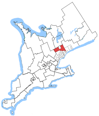
Oak Ridges—Markham was a federal electoral district in Ontario, Canada, that was represented in the House of Commons of Canada from 2004 to 2015. Its population in 2006 was 169,645., with 136,755 electors, the highest of any riding in Canada. By 2011, the riding's population had risen to 228,997, the largest population of all ridings in Canada.

<span class="mw-page-title-main">York North</span> Federal electoral district in Ontario, Canada

York North was a federal riding in Ontario, Canada, that was in the House of Commons of Canada from Confederation in 1867 until 2004.

<span class="mw-page-title-main">Steeles Avenue</span> Road in Ontario, Canada

Steeles Avenue is an east–west street that forms the northern city limit of Toronto and the southern limit of York Region in Ontario, Canada. It stretches 77.3 km (48.0 mi) across the western and central Greater Toronto Area from Appleby Line in Milton in the west to the Toronto-Pickering city limits in the east, where it continues east into Durham Region as Taunton Road, which itself extends 58 km (36 mi) across the length of Durham Region to its boundary with Northumberland County.

King's Highway 48, also known as Highway 48, is a provincially maintained highway in southern Ontario that extends from Major Mackenzie Drive in Markham, through Whitchurch-Stouffville and East Gwillimbury, to Highway 12 south-east of Beaverton. The route is generally rural and straight, passing near several communities within the Regional Municipality of York. The route is 65.2 kilometres (40.5 mi) long. Most part of the road has a speed limit of 80 km/h (50 mph), except within town limits, where the speed limit is reduced to 60 km/h (37 mph) or 50 km/h (31 mph).

<span class="mw-page-title-main">Unionville, Ontario</span> Suburban district in York, Ontario, Canada

Unionville is a suburban district and former village in Markham, Ontario, Canada, 2 km (2.5 mi) west of Markham Village, and 33 km (20.5 mi) northeast of Downtown Toronto. The boundaries of Unionville are not well-defined. Several neighbourhoods claim to be part of it however, this has been disputed between the various wards.

<span class="mw-page-title-main">Markham Transit</span>

Markham Transit was a public transit system for the town of Markham, Ontario, Canada. It was created in 1973 and operated by Travelways and Miller Transit Limited after 1984 on behalf of the then Town of Markham. The service was merged into York Region Transit in 2001 with Miller Transit continuing to operate most Markham routes.

<span class="mw-page-title-main">York East</span> Federal electoral district in Ontario, Canada

York East was a federal electoral district represented in the House of Commons of Canada at different times. It was located in the province of Ontario.

<span class="mw-page-title-main">Markham (federal electoral district)</span> Federal electoral district in Ontario, Canada

Markham was a federal electoral district in Ontario, Canada created in 1988. Also known as Markham—Whitchurch-Stouffville, it was a federal electoral district that elected representatives to the House of Commons of Canada from 1988 to 2000. Notably in 1997 this was the only district in Ontario that did not elect a Liberal MP or an Independent.

<span class="mw-page-title-main">Gormley, Ontario</span> Unincorporated community in Ontario, Canada

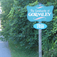
Gormley is a hamlet in York Region, Ontario, Canada that overlaps parts of Richmond Hill, and Whitchurch–Stouffville, two municipalities within the Greater Toronto Area. It was divided into two parts due to the construction of Highway 404. A portion of Gormley situated within Richmond Hill's political boundaries is subject to "Heritage Conservation District" controls. A post office in Gormley (East) serves as the mailing address for the Whitchurch–Stouffville communities of Bethesda, Gormley, Preston Lake, Vandorf, and Wesley Corners.

Vandorf is a hamlet located in the town of Whitchurch–Stouffville, Ontario, in Canada. It is the most westerly settlement within the Town of Whitchurch-Stouffville. With a population of approximately 722, Vandorf consists mainly of estate residential homes and farms.

<span class="mw-page-title-main">Cashel, Markham</span> Unincorporated community in Ontario, Canada

Cashel, Ontario is a small hamlet situated in Unionville, Ontario located at the intersection of Elgin Mills Road and York Regional Road 67. Originally it was called Crosby Corners after John Crosby, the village's first store owner, who came originally from New York State. The name was changed to Cashel in 1851 with the opening of its first post office. It was likely named after Cashel in Ireland. In 1851 the community had a sawmill, cobbler shop, blacksmith shop, wagon shop, inn and tavern, Masonic Lodge, and Presbyterian church. In 1890 Peaches United Church was built on land from farmer Thomas Peach at 10762 McCowan Road. The church is a historic site and not operating since the 1960s to 1970s, but cemetery remains in active use. The east west sideroad along the church was locally called Peaches (Peach's) Sideroad or otherwise known as Elgin Mills Road.

The city of Markham in Ontario, Canada, offers a complex transportation infrastructure. These include airports, highways, public transit, regional roads, municipality-funded roads, and train services.

<span class="mw-page-title-main">Oak Ridges—Markham (provincial electoral district)</span> Former provincial electoral district in Ontario

Oak Ridges—Markham was a provincial electoral district in Ontario, Canada, that was represented in the Legislative Assembly of Ontario between the 2007 provincial election and the 2018 provincial election. Its population in 2006 was 169,645, with 136,755 electors, the highest of any riding in Ontario. It was the fastest growing riding in the province, having experienced a 52.5% increase in population from 2001 to 2006.

References

  1. "City of Markham".
  2. Markham Village - A Brief History 1800-1919 Archived June 10, 2011, at the Wayback Machine , Markham Public Library (website).
  3. http://www.ourroots.ca/page.aspx?id=2871820&qryID=c702bd07-e9f9-47a6-a690-c90bf1358b13 Whitchurch Township