Incidents
| | This section is empty. You can help by adding to it. (January 2017) |
The history of slavery in Montana is generally seen as short and limited. The issue was contentious for the legislature between the creation of the Nebraska Territory (which Montana was a part of) in 1854 and the outbreak of the American Civil War in 1861. However, there was apparently a particular acceptance of African Americans in the Nebraska Territory when they first arrived en masse. According to a publication by the Federal Writers Project,
York, an enslaved African American held by William Clark, traveled and worked with him in 1804 and 1806 as part of the famous Lewis and Clark Expedition's exploration of the Missouri River lands. He was the first black person recorded in what would become Montana. A number of Montana's geographical features were named after York by the expedition, including the Yorks Islands in Broadwater County, Montana, [2] [3] and the "York's Dry Creek", a tributary of the Yellowstone River, in Custer County, Montana. [4]
In 1820, the United States Congress passed the Missouri Compromise. It prohibited slavery in the unorganized lands that would become the Nebraska Territory. The topic of slavery in Nebraska Territory would not be revisited by Congress until 1854.
| | This section is empty. You can help by adding to it. (January 2017) |

The Kansas–Nebraska Act of 1854 was a territorial organic act that created the territories of Kansas and Nebraska. It was drafted by Democratic Senator Stephen A. Douglas, passed by the 33rd United States Congress, and signed into law by President Franklin Pierce. Douglas introduced the bill intending to open up new lands to develop and facilitate the construction of a transcontinental railroad, but the Kansas–Nebraska Act is most notable for effectively repealing the Missouri Compromise, stoking national tensions over slavery, and contributing to a series of armed conflicts known as "Bleeding Kansas".

The Lewis and Clark Expedition, also known as the Corps of Discovery Expedition, was the United States expedition to cross the newly acquired western portion of the country after the Louisiana Purchase. The Corps of Discovery was a select group of U.S. Army and civilian volunteers under the command of Captain Meriwether Lewis and his close friend Second Lieutenant William Clark. Clark and 30 members set out from Camp Dubois, Illinois, on May 14, 1804, met Lewis and ten other members of the group in St. Charles, Missouri, then went up the Missouri River. The expedition crossed the Continental Divide of the Americas near the Lemhi Pass, eventually coming to the Columbia River, and the Pacific Ocean in 1805. The return voyage began on March 23, 1806, at Fort Clatsop, Oregon, and ended on September 23 of the same year.

The Louisiana Purchase was the acquisition of the territory of Louisiana by the United States from the French First Republic in 1803. In return for fifteen million dollars, or approximately eighteen dollars per square mile, the United States nominally acquired a total of 828,000 sq mi in Middle America. However, France only controlled a small fraction of this area, most of which was inhabited by Native Americans; effectively, for the majority of the area, the United States bought the "preemptive" right to obtain "Indian" lands by treaty or by conquest, to the exclusion of other colonial powers.
The Indian Territory and the Indian Territories are terms that generally described an evolving land area set aside by the United States Government for the relocation of Native Americans who held aboriginal title to their land as a sovereign independent state. In general, the tribes ceded land they occupied in exchange for land grants in 1803. The concept of an Indian Territory was an outcome of the US federal government's 18th- and 19th-century policy of Indian removal. After the American Civil War (1861–1865), the policy of the US government was one of assimilation.

Meriwether Lewis was an American explorer, soldier, politician, and public administrator, best known for his role as the leader of the Lewis and Clark Expedition, also known as the Corps of Discovery, with William Clark. Their mission was to explore the territory of the Louisiana Purchase, establish trade with, and sovereignty over the natives near the Missouri River, and claim the Pacific Northwest and Oregon Country for the United States before European nations. They also collected scientific data, and information on indigenous nations. President Thomas Jefferson appointed him Governor of Upper Louisiana in 1806. He died of gunshot wounds in what was either a murder or suicide, in 1809.

The Territory of Kansas was an organized incorporated territory of the United States that existed from May 30, 1854, until January 29, 1861, when the eastern portion of the territory was admitted to the Union as the free state of Kansas.

The Territory of Missouri was an organized incorporated territory of the United States that existed from June 4, 1812, until August 10, 1821. In 1819, the Territory of Arkansas was created from a portion of its southern area. In 1821, a southeastern portion of the territory was admitted to the Union as the State of Missouri, and the rest became unorganized territory for several years.

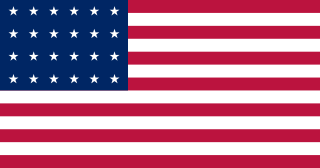
In the United States before 1865, a slave state was a state in which slavery and the internal or domestic slave trade were legal, while a free state was one in which they were not. Between 1812 and 1850, it was considered by the slave states to be politically imperative that the number of free states not exceed the number of slave states, so new states were admitted in slave–free pairs. There were, nonetheless, some slaves in most free states up to the 1840 census, and the Fugitive Slave Act of 1850 specifically stated that a slave did not become free by entering a free state.
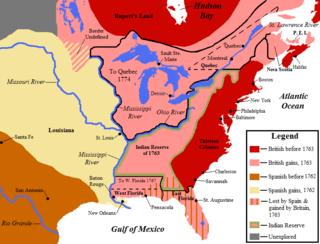
The territory of the United States and its overseas possessions has evolved over time, from the colonial era to the present day. It includes formally organized territories, proposed and failed states, unrecognized breakaway states, international and interstate purchases, cessions, and land grants, and historical military departments and administrative districts. The last section lists informal regions from American vernacular geography known by popular nicknames and linked by geographical, cultural, or economic similarities, some of which are still in use today.

The Platte Purchase was a land acquisition in 1836 by the United States government from American Indian tribes of the region. It comprised lands along the east bank of the Missouri River and added 3,149 square miles (8,156 km2) to the northwest corner of the state of Missouri.

The Otoe are a Native American people of the Midwestern United States. The Otoe language, Chiwere, is part of the Siouan family and closely related to that of the related Iowa, Missouria, and Ho-Chunk tribes.
George Drouillard (1773–1810) was a civilian interpreter, scout, hunter, and cartographer, hired for Lewis and Clark's Voyage of Discovery to explore the territory of the Louisiana Purchase in 1804–1806, in search of a water route to the Pacific Ocean. He later worked as a guide and trapper for Manuel Lisa on the upper Missouri River, joining his Missouri Fur Company in 1809. It is believed that Drouillard was killed in what is now the state of Montana while trapping beaver, in an attack by the Blackfeet or Gros Ventre tribes.
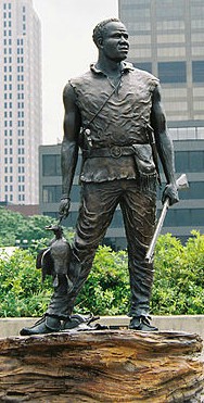
York was an American explorer and historic figure, being the only African-American member of the Lewis and Clark Expedition; he participated in the entire exploration and made significant contributions to its success. He was the first African American to cross the continent and see the Pacific. He has become an American icon and several monuments depicting him have been erected honoring his legacy.

The Great Falls of the Missouri River are a series of waterfalls on the upper Missouri River in north-central Montana in the United States. From upstream to downstream, the five falls along a 10-mile (16 km) segment of the river are:
The history of slavery in Nebraska is generally seen as short and limited. The issue was contentious for the legislature between the creation of the Nebraska Territory in 1854 and the outbreak of the American Civil War in 1861.

Sacagawea was a Lemhi Shoshone woman who, in her teens, helped the Lewis and Clark Expedition in achieving their chartered mission objectives by exploring the Louisiana Territory. Sacagawea traveled with the expedition thousands of miles from North Dakota to the Pacific Ocean, helping to establish cultural contacts with Native American people and contributing to the expedition's knowledge of natural history in different regions.
The following outline is provided as an overview of and topical guide to the U.S. state of Nebraska:
Yorks Islands, also known as "Yorks 8 Islands" or "York's Islands" or simply "York Island(s)" are a group of several islands in the flood plain of the Missouri River, in Broadwater County, Montana, about 4 miles south (up-river) from Townsend, Montana, along U.S. Highway 287. The islands were named by the Lewis and Clark Expedition (1803–1806) for Clark's slave York, when the expedition passed this way in 1805 on their historic journey of exploration to the Pacific Ocean. The islands may be accessed from U.S.287, as a Montana Fishing Access site.

Tower Rock State Park is a state park near the community of Cascade in the U.S. state of Montana in the United States. The centerpiece of the park is Tower Rock, a 424-foot (129 m)-high rock formation which marks the entrance to the Missouri River Canyon in the Adel Mountains Volcanic Field. It was well known to Native Americans, and considered a sacred place by the Piegan Blackfeet. Tower Rock received its current name when Meriwether Lewis of the Lewis and Clark Expedition visited the site in 1805. Railroad and highway development in the late 1800s and 1900s skirted Tower Rock, but the landform itself remained pristine. The 87.2 acres (0.353 km2) encompassing Tower Rock was added to the National Register of Historic Places on March 18, 2002. The 140-acre (0.57 km2) Tower Rock State Park was created around the National Historic Site in 2004.
The history of slavery in South Dakota is generally seen as short and limited. The issue was contentious for the legislature between the creation of the Nebraska Territory in 1854 and the outbreak of the American Civil War in 1861. However, there was apparently a particular acceptance of African Americans in the Nebraska Territory when they first arrived en masse. According to a publication by the Federal Writers Project,
In the Territory of Nebraska the fight to exclude slavery from within the territorial boundaries spread from the Senate to the press and to the pulpit. Even among the slaves in the South the word spread that here was a place where the attitude toward Negroes was tempered with tolerance.
| | This article relating to the history of the United States is a stub. You can help Wikipedia by expanding it. |