
A minute of arc, arcminute (arcmin), arc minute, or minute arc, denoted by the symbol ′, is a unit of angular measurement equal to 1/60 of one degree. Since one degree is 1/360 of a turn, one arcminute is 1/21600 of a turn. The nautical mile (nmi) was originally defined as the arc length of a minute of latitude on a spherical Earth, so the actual Earth circumference is very near 21600 nmi. A minute of arc is π/10800 of a radian.

In astronomy, declination is one of the two angles that locate a point on the celestial sphere in the equatorial coordinate system, the other being hour angle. Declination's angle is measured north or south of the celestial equator, along the hour circle passing through the point in question.

In geography, latitude is a coordinate that specifies the north–south position of a point on the surface of the Earth or another celestial body. Latitude is given as an angle that ranges from –90° at the south pole to 90° at the north pole, with 0° at the Equator. Lines of constant latitude, or parallels, run east–west as circles parallel to the equator. Latitude and longitude are used together as a coordinate pair to specify a location on the surface of the Earth.
Right ascension is the angular distance of a particular point measured eastward along the celestial equator from the Sun at the March equinox to the point in question above the earth. When paired with declination, these astronomical coordinates specify the location of a point on the celestial sphere in the equatorial coordinate system.
A solstice is an event that occurs when the Sun appears to reach its most northerly or southerly excursion relative to the celestial equator on the celestial sphere. Two solstices occur annually, around June 21 and December 21. In many countries, the seasons of the year are determined by the solstices and the equinoxes.
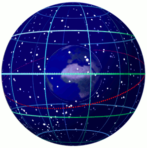
In astronomy and navigation, the celestial sphere is an abstract sphere that has an arbitrarily large radius and is concentric to Earth. All objects in the sky can be conceived as being projected upon the inner surface of the celestial sphere, which may be centered on Earth or the observer. If centered on the observer, half of the sphere would resemble a hemispherical screen over the observing location.

The north and south celestial poles are the two points in the sky where Earth's axis of rotation, indefinitely extended, intersects the celestial sphere. The north and south celestial poles appear permanently directly overhead to observers at Earth's North Pole and South Pole, respectively. As Earth spins on its axis, the two celestial poles remain fixed in the sky, and all other celestial points appear to rotate around them, completing one circuit per day.
The equatorial coordinate system is a celestial coordinate system widely used to specify the positions of celestial objects. It may be implemented in spherical or rectangular coordinates, both defined by an origin at the centre of Earth, a fundamental plane consisting of the projection of Earth's equator onto the celestial sphere, a primary direction towards the vernal equinox, and a right-handed convention.

The horizontal coordinate system is a celestial coordinate system that uses the observer's local horizon as the fundamental plane to define two angles: altitude and azimuth. Therefore, the horizontal coordinate system is sometimes called as the az/el system, the alt/az system, or the alt-azimuth system, among others. In an altazimuth mount of a telescope, the instrument's two axes follow altitude and azimuth.

Sidereal time is a timekeeping system that astronomers use to locate celestial objects. Using sidereal time, it is possible to easily point a telescope to the proper coordinates in the night sky. Sidereal time is a "time scale that is based on Earth's rate of rotation measured relative to the fixed stars", or more correctly, relative to the March equinox.

In astronomy and celestial navigation, the hour angle is the angle between two planes: one containing Earth's axis and the zenith, and the other containing Earth's axis and a given point of interest.

In astronomy, an analemma is a diagram showing the position of the Sun in the sky as seen from a fixed location on Earth at the same mean solar time, as that position varies over the course of a year. The diagram will resemble a figure eight. Globes of Earth often display an analemma as a two-dimensional figure of equation of time vs. declination of the Sun.
Diurnal motion is an astronomical term referring to the apparent motion of celestial objects around Earth, or more precisely around the two celestial poles, over the course of one day. It is caused by Earth's rotation around its axis, so almost every star appears to follow a circular arc path, called the diurnal circle, often depicted in star trail photography.
The celestial equator is the great circle of the imaginary celestial sphere on the same plane as the equator of Earth. By extension, it is also a plane of reference in the equatorial coordinate system. In other words, the celestial equator is an abstract projection of the terrestrial equator into outer space. Due to Earth's axial tilt, the celestial equator is currently inclined by about 23.44° with respect to the ecliptic, but has varied from about 22.0° to 24.5° over the past 5 million years due to perturbation from other planets.
In observational astronomy, culmination is the passage of a celestial object across the observer's local meridian. These events were also known as meridian transits, used in timekeeping and navigation, and measured precisely using a transit telescope.
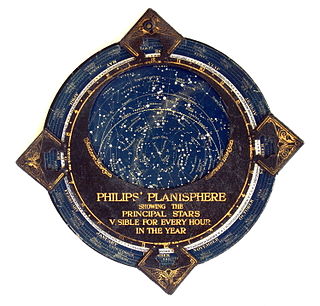
In astronomy, a planisphere is a star chart analog computing instrument in the form of two adjustable disks that rotate on a common pivot. It can be adjusted to display the visible stars for any time and date. It is an instrument to assist in learning how to recognize stars and constellations. The astrolabe, an instrument that has its origins in Hellenistic astronomy, is a predecessor of the modern planisphere. The term planisphere contrasts with armillary sphere, where the celestial sphere is represented by a three-dimensional framework of rings.

In astronomy, the meridian is the great circle passing through the celestial poles, as well as the zenith and nadir of an observer's location. Consequently, it contains also the north and south points on the horizon, and it is perpendicular to the celestial equator and horizon. Meridians, celestial and geographical, are determined by the pencil of planes passing through the Earth's rotation axis. For a location not at a geographical pole, there is a unique meridian plane in this axial-pencil through that location. The intersection of this plane with Earth's surface is the geographical meridian, and the intersection of the plane with the celestial sphere is the celestial meridian for that location and time.

Spherical astronomy, or positional astronomy, is a branch of observational astronomy used to locate astronomical objects on the celestial sphere, as seen at a particular date, time, and location on Earth. It relies on the mathematical methods of spherical trigonometry and the measurements of astrometry.
In astronomy, an equinox is either of two places on the celestial sphere at which the ecliptic intersects the celestial equator. Although there are two such intersections, the equinox associated with the Sun's ascending node is used as the conventional origin of celestial coordinate systems and referred to simply as "the equinox". In contrast to the common usage of spring/vernal and autumnal equinoxes, the celestial coordinate system equinox is a direction in space rather than a moment in time.
This glossary of astronomy is a list of definitions of terms and concepts relevant to astronomy and cosmology, their sub-disciplines, and related fields. Astronomy is concerned with the study of celestial objects and phenomena that originate outside the atmosphere of Earth. The field of astronomy features an extensive vocabulary and a significant amount of jargon.
