Related Research Articles

Hail is a form of solid precipitation. It is distinct from ice pellets, though the two are often confused. It consists of balls or irregular lumps of ice, each of which is called a hailstone. Ice pellets generally fall in cold weather, while hail growth is greatly inhibited during low surface temperatures.

Ice is water that is frozen into a solid state, typically forming at or below temperatures of 0 °C, 32 °F, or 273.15 K. It occurs naturally on Earth, on other planets, in Oort cloud objects, and as interstellar ice. As a naturally occurring crystalline inorganic solid with an ordered structure, ice is considered to be a mineral. Depending on the presence of impurities such as particles of soil or bubbles of air, it can appear transparent or a more or less opaque bluish-white color.
Lidar is a method for determining ranges by targeting an object or a surface with a laser and measuring the time for the reflected light to return to the receiver. Lidar may operate in a fixed direction or it may scan multiple directions, in which case it is known as lidar scanning or 3D laser scanning, a special combination of 3-D scanning and laser scanning. Lidar has terrestrial, airborne, and mobile applications.

A magnetic anomaly detector (MAD) is an instrument used to detect minute variations in the Earth's magnetic field. The term refers specifically to magnetometers used by military forces to detect submarines ; military MAD equipment is a descendant of geomagnetic survey or aeromagnetic survey instruments used to search for minerals by detecting their disturbance of the normal earth-field.
Freezing rain is rain maintained at temperatures below freezing by the ambient air mass that causes freezing on contact with surfaces. Unlike a mixture of rain and snow or ice pellets, freezing rain is made entirely of liquid droplets. The raindrops become supercooled while passing through a sub-freezing layer of air hundreds of meters above the ground, and then freeze upon impact with any surface they encounter, including the ground, trees, electrical wires, aircraft, and automobiles. The resulting ice, called glaze ice, can accumulate to a thickness of several centimeters and cover all exposed surfaces. The METAR code for freezing rain is FZRA.
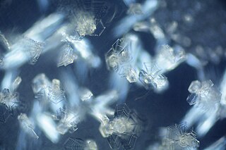
Ice crystals are solid ice in symmetrical shapes including hexagonal columns, hexagonal plates, and dendritic crystals. Ice crystals are responsible for various atmospheric optic displays and cloud formations.

Demining or mine clearance is the process of removing land mines from an area. In military operations, the object is to rapidly clear a path through a minefield, and this is often done with devices such as mine plows and blast waves. By contrast, the goal of humanitarian demining is to remove all of the landmines to a given depth and make the land safe for human use. Specially trained dogs are also used to narrow down the search and verify that an area is cleared. Mechanical devices such as flails and excavators are sometimes used to clear mines.

The IceCube Neutrino Observatory is a neutrino observatory constructed at the Amundsen–Scott South Pole Station in Antarctica. The project is a recognized CERN experiment (RE10). Its thousands of sensors are located under the Antarctic ice, distributed over a cubic kilometre.
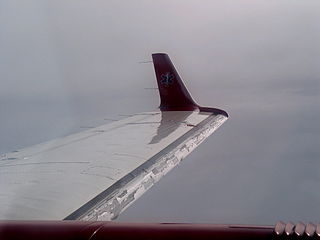
In aviation, icing conditions are atmospheric conditions that can lead to the formation of water ice on an aircraft. Ice accretion and accumulation can affect the external surfaces of an aircraft – in which case it is referred to as airframe icing – or the engine, resulting in carburetor icing, air inlet icing or more generically engine icing. These phenomena may possibly but do not necessarily occur together. Both airframe and engine icing have resulted in numerous fatal accidents in aviation history.

Atmospheric icing occurs in the atmosphere when water droplets suspended in air freeze on objects they come in contact with. It is not the same as freezing rain, which is caused directly by precipitation. Icing conditions can be particularly dangerous to aircraft, as the built-up ice changes the aerodynamics of the flight surfaces and airframe, which can increase the risk of a stall and potentially accidents. For this reason, on-board ice protection systems have been developed on aircraft intended to fly through these conditions.
In ground deicing of aircraft, aircraft deicing fluid (ADF), aircraft deicer and anti-icer fluid (ADAF) or aircraft anti-icing fluid (AAF) are commonly used for both commercial and general aviation. Environmental concerns include increased salinity of groundwater where de-icing fluids are discharged into soil, and toxicity to humans and other mammals.

A lightning detector is a device that detects lightning produced by thunderstorms. There are three primary types of detectors: ground-based systems using multiple antennas, mobile systems using a direction and a sense antenna in the same location, and space-based systems. The first such device was invented in 1894 by Alexander Stepanovich Popov. It was also the first radio receiver in the world.

Tropical cyclone observation has been carried out over the past couple of centuries in various ways. The passage of typhoons, hurricanes, as well as other tropical cyclones have been detected by word of mouth from sailors recently coming to port or by radio transmissions from ships at sea, from sediment deposits in near shore estuaries, to the wiping out of cities near the coastline. Since World War II, advances in technology have included using planes to survey the ocean basins, satellites to monitor the world's oceans from outer space using a variety of methods, radars to monitor their progress near the coastline, and recently the introduction of unmanned aerial vehicles to penetrate storms. Recent studies have concentrated on studying hurricane impacts lying within rocks or near shore lake sediments, which are branches of a new field known as paleotempestology. This article details the various methods employed in the creation of the hurricane database, as well as reconstructions necessary for reanalysis of past storms used in projects such as the Atlantic hurricane reanalysis.
Geophysical MASINT is a branch of Measurement and Signature Intelligence (MASINT) that involves phenomena transmitted through the earth and manmade structures including emitted or reflected sounds, pressure waves, vibrations, and magnetic field or ionosphere disturbances.

Airport weather stations are automated sensor suites which are designed to serve aviation and meteorological operations, weather forecasting and climatology. Automated airport weather stations have become part of the backbone of weather observing in the United States and Canada and are becoming increasingly more prevalent worldwide due to their efficiency and cost-savings.

A wake low, or wake depression, is a mesoscale low-pressure area which trails the mesoscale high following a squall line. Due to the subsiding warm air associated with the system's formation, clearing skies are associated with the wake low. Once difficult to detect in surface weather observations due to their broad spacing, the formation of mesoscale weather station networks, or mesonets, has increased their detection. Severe weather, in the form of high winds, can be generated by the wake low when the pressure difference between the mesohigh preceding it and the wake low is intense enough. When the squall line is in the process of decay, heat bursts can be generated near the wake low. Once new thunderstorm activity along the squall line concludes, the wake low associated with it weakens in tandem.
Atmospheric lidar is a class of instruments that uses laser light to study atmospheric properties from the ground up to the top of the atmosphere. Such instruments have been used to study, among other, atmospheric gases, aerosols, clouds, and temperature.

The present weather sensor (PWS) is a component of an automatic weather station that detects the presence of hydrometeors and determines their type and intensity. It works on a principle similar to a bistatic radar, noting the passage of droplets, or flakes, between a transmitter and a sensor. These instruments in automatic weather stations are used to simulate the observation taken by a human observer. They allow rapid reporting of any change in the type and intensity of precipitation, but include interpretation limitations.

In aviation, ground deicing of aircraft is the process of removing surface frost, ice or frozen contaminants on aircraft surfaces before an aircraft takes off. This prevents even a small amount of surface frost or ice on aircraft surfaces from severely impacting flight performance. Frozen contaminants on surfaces can also break off in flight, damaging engines or control surfaces.
A weather drone, or weather-sensing uncrewed aerial vehicle (UAV), – is a remotely piloted aircraft weighing less than 25 kg and carrying sensors that collect thermodynamic and kinematic data from the mid and lower atmosphere.
References
- ↑ Jackson, Darren G.; Goldberg, Joshua I. (2007-09-24). "Ice Detection Systems: A Historical Perspective". SAE Technical Paper Series. 1. Warrendale, PA: SAE International. doi:10.4271/2007-01-3325.
- ↑ Hann, Richard; Johansen, Tor (2020). "Unsettled Topics in Unmanned Aerial Vehicle Icing (EPR2020008 Research Report) - SAE Mobilus". saemobilus.sae.org. doi:10.4271/epr2020008. hdl: 11250/3113980 . S2CID 226200723 . Retrieved 2021-02-14.
- ↑ Overland, J. E.; Pease, C. H.; Preisendorfer, R. W.; Comiskey, A. L. (December 1986). "Prediction of Vessel Icing". Journal of Climate and Applied Meteorology. 25 (12): 1793–1806. Bibcode:1986JApMe..25.1793O. doi: 10.1175/1520-0450(1986)025<1793:povi>2.0.co;2 . ISSN 0733-3021.
- ↑ Homola, Matthew C.; Nicklasson, Per J.; Sundsbø, Per A. (2006-11-01). "Ice sensors for wind turbines". Cold Regions Science and Technology. 46 (2): 125–131. Bibcode:2006CRST...46..125H. doi:10.1016/j.coldregions.2006.06.005. ISSN 0165-232X.
- ↑ Farzaneh, Masoud, ed. (2008). Atmospheric Icing of Power Networks. Dordrecht: Springer Netherlands. doi:10.1007/978-1-4020-8531-4. ISBN 978-1-4020-8530-7.
- ↑ "Glossary of Meteorology".
- ↑ Deiler, Christoph; Fezans, Nicolas (2020-01-29). "Performance-Based Ice Detection Methodology". Journal of Aircraft. 57 (2): 209–223. doi:10.2514/1.C034828. S2CID 220383280.