Indianola, Washington

Last updated

Indianola, Washington
CDP
IndianolaWA.jpg
Nickname: 
"Ola"
Kitsap County Washington Incorporated and Unincorporated areas Indianola Highlighted.svg
Location of Indianola, Washington
Coordinates: 47°45′5″N122°31′22″W / 47.75139°N 122.52278°W / 47.75139; -122.52278
Country United States
State Washington
County Kitsap
Area
  Total5.3 sq mi (13.8 km2)
  Land4.9 sq mi (12.6 km2)
  Water0.5 sq mi (1.2 km2)
Elevation
43 ft (13 m)
Population
 (2020)
  Total3,664
  Density623.6/sq mi (240.8/km2)
Time zone UTC-8 (Pacific (PST))
  Summer (DST) UTC-7 (PDT)
ZIP code
98342
Area code 360
FIPS code 53-33280 [1]
GNIS feature ID1533572 [2]
Historical population
CensusPop.Note
2010 3,500
2020 3,6644.7%
Sources: [3] [4]
Indianola beach seen from a seaplane. IndianolaSeaplane.jpg
Indianola beach seen from a seaplane.

Indianola is a census-designated place (CDP) in Kitsap County, Washington, United States, located on the north shore of Port Madison on the Port Madison Indian Reservation, home of the Suquamish Indian Tribe. The population was 3,664 at the 2020 census. [4] It was originally established as a summer community and was a stop for Mosquito Fleet ferries until the 1950s.

Contents

Geography

Indianola is located at 47°45′5″N122°31′22″W / 47.75139°N 122.52278°W / 47.75139; -122.52278 (47.751512, -122.522878). [3] It lies on the north shore of Port Madison, just east of Miller Bay. It is south of Kingston and northeast of Suquamish.

According to the United States Census Bureau, the CDP has a total area of 5.3 square miles (13.8 km2), of which, 4.8 square miles (12.6 km2) of it is land and 0.5 square miles (1.2 km2) of it (8.82%) is water.

History

Indianola was formed on the portion of the Port Madison Indian Reservation which had been allotted to KaKue aka "Beedee" in 1886. KaKue died in December 1886 leaving no will and his wife Tu Tue Tue was sole heir. Tu Tue Tue died four years later in 1890 leaving a brother and a sister Tar-de-blu & a daughter Katie. After the death of Tar-de-blu the estate was settled in 1909 leaving Chief Jacob the son of Tar-de-blu as sole heir. When Katie died childless in 1896 her husband Alpheus Loughrey was sole heir. Alpheus had four sons from a previous marriage and the allotment eventually passed to his sons, Alpheus was a white man who had married Katie, the daughter of KaKue aka Beedee and Tu-Tue-Tue. [5] KaKue aka "Beedee" was not related to Cyrus Beede Pickrell who was an Indian agent in Suquamish from 1906-1916 or to Cyrus Beede who was at the time the US Indian Inspector.

Development began in 1916 with the formation of the Indianola Beach Land Company by W. L. Gazzam to promote real estate sales on the land owned by the Loughreys. A dock and a store were built as amenities to attract buyers; a second store, the Beachcomber, was built the next year. From the beginning, Indianola has been a vacation community, with its population inflating considerably in the summertime.

In the early 20th century, most transportation on Puget Sound was by steamer, and a community’s dock was often its only lifeline to the outside world. Such was the case for the young community of Indianola Beach, and by 1918 a steamer was docking there every weekend. Daily ferry service was initiated in 1919 when Carl Hendrix organized twelve passengers to pay in advance for one year’s daily service between Indianola Beach and Seattle. Hendrix and his wife established a school the same year.

Cyrus Beede Pickrell, who had been Indian Agent for the Port Madison Reservation, moved to Indianola Beach from Suquamish with his family in 1920. Postal service had been discontinued, so when the Pickrells opened a new store, they housed the postal operation at Indianola Beach with Cyrus as Postmaster. Around this time, the Postmaster General took issue with the double name of Indianola Beach and the post office was renamed Kitsap in honor of Chief Kitsap of the Suquamish tribe.

Plans to establish a library and community hall were cause for much activity and development in the 1920s. Lots were auctioned off and a carnival was held in 1927 to raise funds. The Indianola Beach Improvement Club was incorporated in 1928 to raise more building money. The Club acquired some lots from W. L. Gazzam, which were raffled off with the proceeds going toward the purchase of property on which to build the structure. The Indianola Clubhouse was finally built in 1930.

By 1929, three passenger boats left the Indianola dock for Seattle every day, and the 1930s brought more connections to the outside world. A power line was strung in 1930, and phone service was established in 1934. The Port of Indianola was established in 1933 after a special election. The dock, which had previously only accommodated passengers, was widened and reinforced to allow auto access. In 1935, Kitsap County began taking surveys to build a road to connect Indianola and Suquamish; when the road was completed in 1939, it was the first time Indianola was accessible by other means of transportation than boat.

Indianola Dock, as seen from the beach. IndianolaPier.jpg
Indianola Dock, as seen from the beach.

Road access to Indianola changed the character of the community somewhat, as the community now had access to more amenities in Kitsap and was no longer self-contained. The school closed in 1941 after more than twenty years of classes. Kitsap County’s naval bases and facilities brought a population boom during World War II, and many families settled in Indianola. Ferry service was discontinued in Fall of 1951 after the Agate Pass Bridge opened and the Washington State Ferries took over ferry service on Puget Sound.

It was not until after 1957 that the name of the post office was changed from Kitsap to Indianola, due to the confusion caused by its sharing a name with the county.

Demographics

As of the census [1] of 2000, there were 3,026 people, 1,140 households, and 855 families residing in the CDP. The population density was 623.6 people per square mile (240.9/km2). There were 1,304 housing units at an average density of 268.7/sq mi (103.8/km2). The racial makeup of the CDP was 87.7% White, 0.5% African American, 5.3% Native American, 1.4% Asian, 0.3% Pacific Islander, 0.8% from other races, and 3.9% from two or more races. Hispanic or Latino of any race were 2.7% of the population.

There were 1,140 households, out of which 40.4% had children under the age of 18 living with them, 62.9% were married couples living together, 8.8% had a female householder with no husband present, and 25.0% were non-families. 19.0% of all households were made up of individuals, and 4.3% had someone living alone who was 65 years of age or older. The average household size was 2.65 and the average family size was 3.04.

In the CDP, the population was spread out, with 29.6% under the age of 18, 5.0% from 18 to 24, 33.7% from 25 to 44, 24.1% from 45 to 64, and 7.5% who were 65 years of age or older. The median age was 36 years. For every 100 females, there were 101.1 males. For every 100 females age 18 and over, there were 97.2 males.

The median income for a household in the CDP was $52,852, and the median income for a family was $60,028. Males had a median income of $43,633 versus $30,208 for females. The per capita income for the CDP was $22,895. About 3.2% of families and 5.3% of the population were below the poverty line, including 7.3% of those under age 18 and 4.2% of those age 65 or over.

Related Research Articles

<span class="mw-page-title-main">Kitsap County, Washington</span> County in Washington, United States

Kitsap County is located in the U.S. state of Washington. As of the 2020 census, its population was 275,611. Its county seat is Port Orchard; its largest city is Bremerton. The county, formed out of King County and Jefferson County on January 16, 1857, is named for Chief Kitsap of the Suquamish Tribe. Originally named Slaughter County, it was soon renamed.

<span class="mw-page-title-main">Port Costa, California</span> Census-designated place in California, United States

Port Costa is a small town and census-designated place (CDP) in Contra Costa County, California, located in East Bay region of the San Francisco Bay Area. Situated on the southern shore of the Carquinez Strait, the population was 242 at the 2020 based on United States Census Bureau.

<span class="mw-page-title-main">Pearl Beach, St. Clair County, Michigan</span> Census-designated place & unincorporated community in Michigan, United States

Pearl Beach is an unincorporated community and census-designated place (CDP) in St. Clair County in the U.S. state of Michigan. The population of the CDP was 4,698 at the 2020 census. The community is located within Clay Township.

<span class="mw-page-title-main">University Park, New Mexico</span> Census-designated place in New Mexico, United States

University Park is a census-designated place (CDP) in Doña Ana County, New Mexico, United States. The population was 4,192 at the 2010 census. It is part of the Las Cruces Metropolitan Statistical Area.

<span class="mw-page-title-main">Clinton, Washington</span> CDP in Washington, United States

Clinton is a community and census-designated place (CDP) located on southern Whidbey Island in Island County, Washington, United States. The town was named after Clinton, Michigan. As of the 2010 census, the population was 928. However, the post office serves at least 2,500 people.

<span class="mw-page-title-main">Bainbridge Island, Washington</span> City in Washington, United States

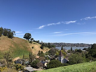
Bainbridge Island is a city and island in Kitsap County, Washington, United States. It is located in Puget Sound. The population was 24,825 at the 2020 census, making Bainbridge Island the second largest city in Kitsap County.

<span class="mw-page-title-main">Bremerton, Washington</span> City in Washington, United States

Bremerton is a city in Kitsap County, Washington. The population was 43,505 at the 2020 census and an estimated 44,122 in 2021, making it the largest city on the Kitsap Peninsula. Bremerton is home to Puget Sound Naval Shipyard and the Bremerton Annex of Naval Base Kitsap.

<span class="mw-page-title-main">East Port Orchard, Washington</span> CDP in Washington, United States

East Port Orchard is a census-designated place (CDP) in Kitsap County, Washington, United States. The population was 5,262 at the 2020 census.

<span class="mw-page-title-main">Erlands Point-Kitsap Lake, Washington</span> Former CDP in Washington, United States

Erlands Point-Kitsap Lake is an unincorporated area and former census-designated place (CDP) in Kitsap County, Washington, United States. The population was 2,935 at the 2010 census. For the 2020 census, the area was split into two CDPs, Erlands Point and Kitsap Lake.

<span class="mw-page-title-main">Kingston, Washington</span> Census-designated place in Washington, United States

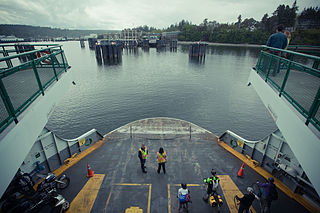
Kingston is an unincorporated community and census-designated place (CDP) in Kitsap County, Washington, United States. The population was 2,515 at the 2020 census. Kingston is along the shores of Appletree Cove and Puget Sound, and is home to a major Washington State Ferry terminal linking it to Edmonds.

<span class="mw-page-title-main">Manchester, Washington</span> Census-designated place in Washington, United States

Manchester is an unincorporated community and census-designated place (CDP) in Kitsap County, Washington, United States. The population was 5,714 at the 2020 census. Manchester is located on the Puget Sound approximately 10 miles from downtown Seattle, and is adjacent to county seat Port Orchard to its east. Today, Manchester labels itself as a village. It is small in size but is home to a Kitsap Regional Library (KRL) branch, a post office, an elementary school, and a beachfront park to serve its residents.

<span class="mw-page-title-main">Port Orchard, Washington</span> City in Washington, United States

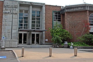
Port Orchard is a city in and the county seat of Kitsap County, Washington, United States. It is located 13 miles (21 km) due west of West Seattle and is connected to Seattle and Vashon Island via the Washington State Ferries run to Southworth. It is named after Port Orchard, the strait that separates Bainbridge Island from the Kitsap Peninsula.

<span class="mw-page-title-main">Poulsbo, Washington</span> City in Washington, United States

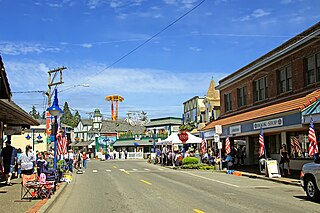
Poulsbo is a city on Liberty Bay in Kitsap County, Washington, United States. It is the smallest of the four cities in Kitsap County. The population was 11,970 at the 2020 census and an estimated 10,927 in 2018.

<span class="mw-page-title-main">Suquamish, Washington</span> Census-designated place in Washington, United States

Suquamish is a census-designated place (CDP) in Kitsap County, Washington, United States. The population was 4,266 at the 2020 census. Comprising the Port Madison Indian Reservation, it is the burial site of Chief Seattle and was the site of the Suquamish tribe winter longhouse known as the Old Man House.

<span class="mw-page-title-main">Kitsap Peninsula</span> Peninsula in Puget Sound, Washington, United States

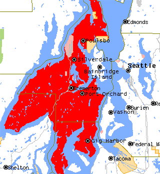
The Kitsap Peninsula lies west of Seattle across Puget Sound, in Washington state in the Pacific Northwest. Hood Canal separates the peninsula from the Olympic Peninsula on its west side. The peninsula, a.k.a. "Kitsap", encompasses all of Kitsap County except Bainbridge and Blake Islands, as well as the northeastern part of Mason County and the northwestern part of Pierce County. The highest point on the Kitsap Peninsula is Gold Mountain. The U.S. Navy's Puget Sound Naval Shipyard, and Naval Base Kitsap are on the peninsula. Its main city is Bremerton.

<span class="mw-page-title-main">Seabeck, Washington</span> Census-designated place in Washington, United States

Seabeck is an unincorporated community and census-designated place (CDP) in Kitsap County, Washington, United States. The population was 1,105 at the 2010 census. Seabeck is a former mill town on Hood Canal.

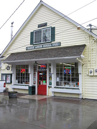
Southworth is an unincorporated community and census-designated place (CDP) on Puget Sound in Kitsap County, Washington, United States. It is best known for being the west end of the Fauntleroy-Vashon Island-Southworth Washington State Ferries run. Landmarks include Southworth Grocery, a US Post Office, ferry terminal, clay cliffs and a private beach on the point. Next to the ferry is a popular place to launch kayaks for trips to nearby Blake Island. The population of the Southworth CDP was 2,185 at the 2010 census.

<span class="mw-page-title-main">Hansville, Washington</span> Census-designated place in Washington, United States

Hansville is an unincorporated community and census-designated place (CDP) in Kitsap County, Washington, United States. Its population was 3,858 as of the 2020 census. The coastal community is located at the northern end of the Kitsap Peninsula and is about 16 miles (26 km) northeast of Poulsbo, the nearest city.

<span class="mw-page-title-main">Port Madison Indian Reservation</span> Native American tribe with reservation in Washington state

The Suquamish Indian Tribe of the Port Madison Reservation is a federally recognized tribe and Indian reservation in the U.S. state of Washington.

The Kitsap County Transportation Company was an important steamboat and ferry company that operated on Puget Sound. The company was founded in 1898 as the Hansen Transportation Company.

References

  1. 1 2 "U.S. Census website". United States Census Bureau . Retrieved January 31, 2008.
  2. "Indianola". Geographic Names Information System . United States Geological Survey, United States Department of the Interior.
  3. 1 2 "US Gazetteer files: 2010, 2000, and 1990". United States Census Bureau. February 12, 2011. Retrieved April 23, 2011.
  4. 1 2 "Census Bureau profile: Indianola, Washington". United States Census Bureau. May 2023. Retrieved May 8, 2024.
  5. Meacham, Eva Pickrell (1968). A Chronicle of Indianola. Indianola, WA: Indianola Beach Improvement Club. p. 23.