
Climate variability includes all the variations in the climate that last longer than individual weather events, whereas the term climate change only refers to those variations that persist for a longer period of time, typically decades or more. Climate change may refer to any time in Earth's history, but the term is now commonly used to describe contemporary climate change. Since the Industrial Revolution, the climate has increasingly been affected by human activities.
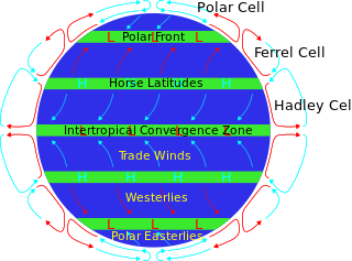
The horse latitudes are the latitudes about 30 degrees north and south of the Equator. They are characterized by sunny skies, calm winds, and very little precipitation. They are also known as subtropical ridges or highs. It is a high-pressure area at the divergence of trade winds and the westerlies.

The tropopause is the atmospheric boundary that demarcates the troposphere from the stratosphere, which are the lowest two of the five layers of the atmosphere of Earth. The tropopause is a thermodynamic gradient-stratification layer, that marks the end of the troposphere, and is approximately 17 kilometres (11 mi) above the equatorial regions, and approximately 9 kilometres (5.6 mi) above the polar regions.

Climatology or climate science is the scientific study of Earth's climate, typically defined as weather conditions averaged over a period of at least 30 years. Climate concerns the atmospheric condition during an extended to indefinite period of time; weather is the condition of the atmosphere during a relative brief period of time. The main topics of research are the study of climate variability, mechanisms of climate changes and modern climate change. This topic of study is regarded as part of the atmospheric sciences and a subdivision of physical geography, which is one of the Earth sciences. Climatology includes some aspects of oceanography and biogeochemistry.

El Niño–Southern Oscillation (ENSO) is an irregular periodic variation in winds and sea surface temperatures over the tropical eastern Pacific Ocean, affecting the climate of much of the tropics and subtropics. The warming phase of the sea temperature is known as El Niño and the cooling phase as La Niña. The Southern Oscillation is the accompanying atmospheric component, coupled with the sea temperature change: El Niño is accompanied by high air surface pressure in the tropical western Pacific and La Niña with low air surface pressure there. The two periods last several months each and typically occur every few years with varying intensity per period.
The North Atlantic Oscillation (NAO) is a weather phenomenon over the North Atlantic Ocean of fluctuations in the difference of atmospheric pressure at sea level (SLP) between the Icelandic Low and the Azores High. Through fluctuations in the strength of the Icelandic Low and the Azores High, it controls the strength and direction of westerly winds and location of storm tracks across the North Atlantic.

In meteorology, a low-pressure area, low area or low is a region where the atmospheric pressure is lower than that of surrounding locations. Low-pressure areas are commonly associated with inclement weather, while high-pressure areas are associated with lighter winds and clear skies. Winds circle anti-clockwise around lows in the northern hemisphere, and clockwise in the southern hemisphere, due to opposing Coriolis forces. Low-pressure systems form under areas of wind divergence that occur in the upper levels of the atmosphere (aloft). The formation process of a low-pressure area is known as cyclogenesis. In meteorology, atmospheric divergence aloft occurs in two kinds of places:

The trade winds or easterlies are the permanent east-to-west prevailing winds that flow in the Earth's equatorial region. The trade winds blow mainly from the northeast in the Northern Hemisphere and from the southeast in the Southern Hemisphere, strengthening during the winter and when the Arctic oscillation is in its warm phase. Trade winds have been used by captains of sailing ships to cross the world's oceans for centuries. They enabled colonial expansion into the Americas, and trade routes to become established across the Atlantic Ocean and the Pacific Ocean.

The westerlies, anti-trades, or prevailing westerlies, are prevailing winds from the west toward the east in the middle latitudes between 30 and 60 degrees latitude. They originate from the high-pressure areas in the horse latitudes and trend towards the poles and steer extratropical cyclones in this general manner. Tropical cyclones which cross the subtropical ridge axis into the westerlies recurve due to the increased westerly flow. The winds are predominantly from the southwest in the Northern Hemisphere and from the northwest in the Southern Hemisphere.

The Arctic oscillation (AO) or Northern Annular Mode/Northern Hemisphere Annular Mode (NAM) is a weather phenomenon at the Arctic pole north of 20 degrees latitude. It is an important mode of climate variability for the Northern Hemisphere. The southern hemisphere analogue is called the Antarctic oscillation or Southern Annular Mode (SAM). The index varies over time with no particular periodicity, and is characterized by non-seasonal sea-level pressure anomalies of one sign in the Arctic, balanced by anomalies of opposite sign centered at about 37–45° N.

The Pacific decadal oscillation (PDO) is a robust, recurring pattern of ocean-atmosphere climate variability centered over the mid-latitude Pacific basin. The PDO is detected as warm or cool surface waters in the Pacific Ocean, north of 20°N. Over the past century, the amplitude of this climate pattern has varied irregularly at interannual-to-interdecadal time scales. There is evidence of reversals in the prevailing polarity of the oscillation occurring around 1925, 1947, and 1977; the last two reversals corresponded with dramatic shifts in salmon production regimes in the North Pacific Ocean. This climate pattern also affects coastal sea and continental surface air temperatures from Alaska to California.
The South Pacific Convergence Zone (SPCZ), a reverse-oriented monsoon trough, is a band of low-level convergence, cloudiness and precipitation extending from the Western Pacific Warm Pool at the maritime continent south-eastwards towards French Polynesia and as far as the Cook Islands. The SPCZ is a portion of the Intertropical Convergence Zone (ITCZ) which lies in a band extending east–west near the Equator but can be more extratropical in nature, especially east of the International Date Line. It is considered the largest and most important piece of the ITCZ, and has the least dependence upon heating from a nearby landmass during the summer than any other portion of the monsoon trough. The SPCZ can affect the precipitation on Polynesian islands in the southwest Pacific Ocean, so it is important to understand how the SPCZ behaves with large-scale, global climate phenomenon, such as the ITCZ, El Niño–Southern Oscillation, and the Interdecadal Pacific oscillation (IPO), a portion of the Pacific decadal oscillation.

The Madden–Julian oscillation (MJO) is the largest element of the intraseasonal variability in the tropical atmosphere. It was discovered in 1971 by Roland Madden and Paul Julian of the American National Center for Atmospheric Research (NCAR). It is a large-scale coupling between atmospheric circulation and tropical deep atmospheric convection. Unlike a standing pattern like the El Niño–Southern Oscillation (ENSO), the Madden–Julian oscillation is a traveling pattern that propagates eastward, at approximately 4 to 8 m/s, through the atmosphere above the warm parts of the Indian and Pacific oceans. This overall circulation pattern manifests itself most clearly as anomalous rainfall.

The geography of South America contains many diverse regions and climates. Geographically, South America is generally considered a continent forming the southern portion of the landmass of the Americas, south and east of the Colombia–Panama border by most authorities, or south and east of the Panama Canal by some. South and North America are sometimes considered a single continent or supercontinent, while constituent regions are infrequently considered subcontinents.

Tropical cyclogenesis is the development and strengthening of a tropical cyclone in the atmosphere. The mechanisms through which tropical cyclogenesis occurs are distinctly different from those through which temperate cyclogenesis occurs. Tropical cyclogenesis involves the development of a warm-core cyclone, due to significant convection in a favorable atmospheric environment.
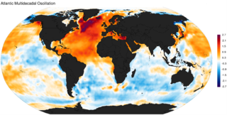
The Atlantic Multidecadal Oscillation (AMO), also known as Atlantic Multidecadal Variability (AMV), is the theorized variability of the sea surface temperature (SST) of the North Atlantic Ocean on the timescale of several decades.
The Pacific–North American teleconnection pattern (PNA) is a climatological term for a large-scale weather pattern with two modes, denoted positive and negative, and which relates the atmospheric circulation pattern over the North Pacific Ocean with the one over the North American continent.
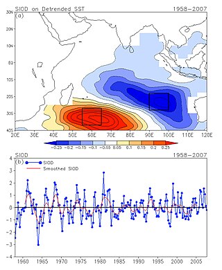
The Subtropical Indian Ocean Dipole (SIOD) is featured by the oscillation of sea surface temperatures (SST) in which the southwest Indian Ocean i.e. south of Madagascar is warmer and then colder than the eastern part i.e. off Australia. It was first identified in the studies of the relationship between the SST anomaly and the south-central Africa rainfall anomaly; the existence of such a dipole was identified from both observational studies and model simulations .
The Tropical Atlantic SST Dipole refers to a cross-equatorial sea surface temperature (SST) pattern that appears dominant on decadal timescales. It has a period of about 12 years, with the SST anomalies manifesting their most pronounced features around 10–15 degrees of latitude off of the Equator. It is also referred to as the interhemispheric SST gradient or the Meridional Atlantic mode.

Pacific Meridional Mode (PMM) is a climate mode in the North Pacific. In its positive state, it is characterized by the coupling of weaker trade winds in the northeast Pacific Ocean between Hawaii and Baja California with decreased evaporation over the ocean, thus increasing sea surface temperatures (SST); and the reverse during its negative state. This coupling develops during the winter months and spreads southwestward towards the equator and the central and western Pacific during spring, until it reaches the Intertropical Convergence Zone (ITCZ), which tends to shift north in response to a positive PMM.
