Related Research Articles

The United States Coast Guard (USCG) is the maritime security, search and rescue, and law enforcement service branch of the United States Armed Forces and one of the country's eight uniformed services. The service is a maritime, military, multi-mission service unique among the United States military branches for having a maritime law enforcement mission with jurisdiction in both domestic and international waters and a federal regulatory agency mission as part of its duties. It is the largest and most powerful coast guard in the world, rivaling the capabilities and size of most navies.

The International Mobile Satellite Organization (IMSO) is the intergovernmental organization that oversees certain public satellite safety and security communication services provided via the Inmarsat satellites. Some of these services concern:

An emergency position-indicating radiobeacon (EPIRB) is a type of emergency locator beacon for commercial and recreational boats, a portable, battery-powered radio transmitter used in emergencies to locate boaters in distress and in need of immediate rescue. In the event of an emergency, such as a ship sinking or medical emergency onboard, the transmitter is activated and begins transmitting a continuous 406 MHz distress radio signal, which is used by search-and-rescue teams to quickly locate the emergency and render aid. The signal is detected by satellites operated by an international consortium of rescue services, COSPAS-SARSAT, which can detect emergency beacons anywhere on Earth transmitting on the distress frequency of 406 MHz. The satellites calculate the position or utilize the GPS coordinates of the beacon and quickly passes the information to the appropriate local first responder organization, which performs the search and rescue. As Search and Rescue approach the search areas, they use Direction Finding (DF) equipment to locate the beacon using the 121.5 MHz homing signal, or in newer EPIRBs, the AIS location signal. The basic purpose of this system is to help rescuers find survivors within the so-called "golden day" during which the majority of survivors can usually be saved. The feature distinguishing a modern EPIRB, often called GPIRB, from other types of emergency beacon is that it contains a GPS receiver and broadcasts its position, usually accurate within 100 m (330 ft), to facilitate location. Previous emergency beacons without a GPS can only be localized to within 2 km (1.2 mi) by the COSPAS satellites and relied heavily upon the 121.5 MHz homing signal to pin-point the beacons location as they arrived on scene.

A coast guard or coastguard is a maritime security organization of a particular country. The term embraces wide range of responsibilities in different countries, from being a heavily armed military force with customs and security duties to being a volunteer organization tasked with search and rescue without law enforcement authority. In most countries, a typical coast guard's functions are distinct from those of the navy and the transit police, while in certain countries they have similarities to both.
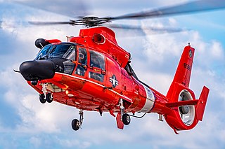
The Eurocopter MH-65 Dolphin is a twin-engined helicopter operated by the United States Coast Guard (USCG) for medevac-capable search and rescue (SAR) and armed Airborne Use of Force missions. It is a variant of the French-built Eurocopter AS365 Dauphin.

Search and rescue (SAR) is the search for and provision of aid to people who are in distress or imminent danger. The general field of search and rescue includes many specialty sub-fields, typically determined by the type of terrain the search is conducted over. These include mountain rescue; ground search and rescue, including the use of search and rescue dogs; urban search and rescue in cities; combat search and rescue on the battlefield and air-sea rescue over water.
His Majesty's Coastguard (HMCG) is a section of the Maritime and Coastguard Agency responsible, through the Secretary of State for Transport to Parliament, for the initiation and co-ordination of all maritime search and rescue (SAR) within the UK Maritime Search and Rescue Region. This includes the mobilisation, organisation and tasking of adequate resources to respond to persons either in distress at sea, or to persons at risk of injury or death on the cliffs or shoreline of the United Kingdom. It is also responsible for land based search and rescue helicopter operations from 2015.
The Global Maritime Distress and Safety System (GMDSS) is a worldwide system for automated emergency signal communication for ships at sea developed by the United Nations' International Maritime Organization (IMO) as part of the SOLAS Convention.
The radiotelephony message PAN-PAN is the international standard urgency signal that someone aboard a boat, ship, aircraft, or other vehicle uses to declare that they have a situation that is urgent, but for the time being, does not pose an immediate danger to anyone's life or to the vessel itself. This is referred to as a state of "urgency". This is distinct from a mayday call, which means that there is imminent danger to life or to the continued viability of the vessel itself. Radioing "pan-pan" informs potential rescuers that an urgent problem exists, whereas "mayday" calls on them to drop all other activities and immediately begin a rescue.
Radiotelephony procedure includes various techniques used to clarify, simplify and standardize spoken communications over two-way radios, in use by the armed forces, in civil aviation, police and fire dispatching systems, citizens' band radio (CB), and amateur radio.

The Canadian Coast Guard Auxiliary is a Canada-wide volunteer marine association dedicated to marine search and rescue (SAR) and the promotion of boating safety, through association with the Canadian Coast Guard under the auspices of Canada's National Search and Rescue Program.

Australian Maritime Safety Authority (AMSA) is an Australian statutory authority responsible for the regulation and safety oversight of Australia's shipping fleet and management of Australia's international maritime obligations. The authority has jurisdiction over Australia's exclusive economic zone which covers an area of 11,000,000 square kilometres (4,200,000 sq mi). AMSA maintains Australia's shipping registries: the general and the international shipping registers.
The International Cospas-Sarsat Programme is a satellite-aided search and rescue (SAR) initiative. It is organized as a treaty-based, nonprofit, intergovernmental, humanitarian cooperative of 45 nations and agencies. It is dedicated to detecting and locating emergency locator radio beacons activated by persons, aircraft or vessels in distress, and forwarding this alert information to authorities that can take action for rescue. Member countries operate a constellation of around 66 satellites orbiting the Earth which carry radio receivers capable of locating an emergency beacon anywhere on Earth transmitting on the Cospas-Sarsat frequency of 406 MHz.

Air-sea rescue, and aeronautical and maritime search and rescue (AMSAR) by the ICAO and IMO, is the coordinated search and rescue (SAR) of the survivors of emergency water landings as well as people who have survived the loss of their seagoing vessel. ASR can involve a wide variety of resources including seaplanes, helicopters, submarines, rescue boats and ships. Specialized equipment and techniques have been developed. Both military and civilian units can perform air-sea rescue. Its principles are laid out in the International Aeronautical and Maritime Search and Rescue Manual. The International Convention on Maritime Search and Rescue is the legal framework that applies to international air-sea rescue.
Procedure words are words or phrases limited to radio telephone procedure used to facilitate communication by conveying information in a condensed standard verbal format. Prowords are voice versions of the much older procedural signs for Morse code which were first developed in the 1860s for Morse telegraphy, and their meaning is identical.
A self-locating datum marker buoy (SLDMB) is a drifting surface buoy designed to measure surface ocean currents. The design is based on those of the Coastal Ocean Dynamics Experiment (CODE) and Davis-style oceanographic surface drifters – National Science Foundation (NSF) funded experiments exploring ocean surface currents. The SLDMB was designed for deployment by United States Coast Guard (USCG) vessels in search and rescue (SAR) missions, and is equipped with a Global Positioning Satellite (GPS) sensor that, upon deployment in fresh- or saltwater, transmits its location periodically to the USCG to aid in SAR missions. Additionally, SLDMB are deployed in oceanographic research in order to study surface currents of the ocean. This design has also been utilized by Nomis Connectivity for secure ocean-based communications.
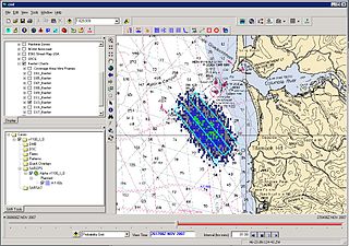
Search and Rescue Optimal Planning System (SAROPS) is a comprehensive search and rescue (SAR) planning system used by the United States Coast Guard in the planning and execution of almost all SAR cases in and around the United States and the Caribbean. SAROPS has three main components: The Graphical User Interface (GUI), the Environmental Data Server (EDS) and the Simulator (SIM). Using the Commercial Joint Mapping Tool Kit's (C/JMTK) government licensing of the Geographic Information System (GIS) SAROPS can be used in both a coastal and oceanic environment. Built into the simulator is the ability to access global and regional wind and current data sets making SAROPS the most comprehensive and powerful tool available for maritime SAR planners.
A rescue co-ordination centre (RCC) is a primary search and rescue facility in a country that is staffed by supervisory personnel and equipped for co-ordinating and controlling search and rescue operations.
The Cyprus Joint Rescue Coordination Center or JRCC Larnaca is an independent agency of the Ministry of Defence of the Republic of Cyprus and its primary mission is to organize the national Search and Rescue (SAR) system, to co-ordinate, to control and direct SAR operations in the region that the Cyprus JRCC is responsible for, so that people, whose lives are at risk as a result of aviation or maritime accidents, can be located and rescued in the least amount of time.

The Joint Arctic Command is a direct Level II authority in the Danish Defence. Joint Arctic Command's primary mission in peacetime is to ensure Danish sovereignty by monitoring the area around the Faroe Islands and Greenland. The command also handles tasks such as fisheries inspection, Search and Rescue (SAR), patient transport and other tasks that support the civil society. In short, the Joint Arctic Command handles military tasks, coast guard duties and disaster response - all in one organisation.
References
- ↑ "ISMAR Manual brochure" (PDF).
- ↑ "ISMAR Manual".
- ↑ "Integrated Man Overboard SAR Systems Needed".
- ↑ "United States National Search and Rescue Plan" (PDF).
- ↑ "US Coast Guard Addendum To The United States National Search And Rescue Supplement (NSS)" (PDF).
- ↑ "USCG Radiotelephone Handbook" (PDF).
- ↑ "MH370, Polar Code Spark SAR Rethink".
- ↑ "Civil Aviation Search and Rescue Worldwide".