Related Research Articles

The cryosphere is an all-encompassing term for the portions of Earth's surface where water is in solid form, including sea ice, lake ice, river ice, snow cover, glaciers, ice caps, ice sheets, and frozen ground. Thus, there is a wide overlap with the hydrosphere. The cryosphere is an integral part of the global climate system. It also has important feedbacks on the climate system. These feedbacks come from the cryosphere's influence on surface energy and moisture fluxes, clouds, the water cycle, atmospheric and oceanic circulation.

An ice shelf is a large platform of glacial ice floating on the ocean, fed by one or multiple tributary glaciers. Ice shelves form along coastlines where the ice thickness is insufficient to displace the more dense surrounding ocean water. The boundary between the ice shelf (floating) and grounded ice is referred to as the grounding line; the boundary between the ice shelf and the open ocean is the ice front or calving front.

In glaciology, an ice sheet, also known as a continental glacier, is a mass of glacial ice that covers surrounding terrain and is greater than 50,000 km2 (19,000 sq mi). The only current ice sheets are the Antarctic ice sheet and the Greenland ice sheet. Ice sheets are bigger than ice shelves or alpine glaciers. Masses of ice covering less than 50,000 km2 are termed an ice cap. An ice cap will typically feed a series of glaciers around its periphery.
The Gravity Recovery and Climate Experiment (GRACE) was a joint mission of NASA and the German Aerospace Center (DLR). Twin satellites took detailed measurements of Earth's gravity field anomalies from its launch in March 2002 to the end of its science mission in October 2017. The two satellites were sometimes called Tom and Jerry, a nod to the famous cartoon. The GRACE Follow-On (GRACE-FO) is a continuation of the mission on near-identical hardware, launched in May 2018. On March 19, 2024, NASA announced that the successor to GRACE-FO would be Gravity Recovery and Climate Experiment-Continuity (GRACE-C), to be launched in or after 2028.

The Antarctic ice sheet is a continental glacier covering 98% of the Antarctic continent, with an area of 14 million square kilometres and an average thickness of over 2 kilometres (1.2 mi). It is the largest of Earth's two current ice sheets, containing 26.5 million cubic kilometres of ice, which is equivalent to 61% of all fresh water on Earth. Its surface is nearly continuous, and the only ice-free areas on the continent are the dry valleys, nunataks of the Antarctic mountain ranges, and sparse coastal bedrock. However, it is often subdivided into East Antarctic ice sheet (EAIS), West Antarctic ice sheet (WAIS), and Antarctic Peninsula (AP), due to the large differences in topography, ice flow, and glacier mass balance between the three regions.

The Greenland ice sheet is an ice sheet which forms the second largest body of ice in the world. It is an average of 1.67 km (1.0 mi) thick, and over 3 km (1.9 mi) thick at its maximum. It is almost 2,900 kilometres (1,800 mi) long in a north–south direction, with a maximum width of 1,100 kilometres (680 mi) at a latitude of 77°N, near its northern edge. The ice sheet covers 1,710,000 square kilometres (660,000 sq mi), around 80% of the surface of Greenland, or about 12% of the area of the Antarctic ice sheet. The term 'Greenland ice sheet' is often shortened to GIS or GrIS in scientific literature.

Thwaites Glacier is an unusually broad and vast Antarctic glacier located east of Mount Murphy, on the Walgreen Coast of Marie Byrd Land. It was initially sighted by polar researchers in 1940, mapped in 1959–1966 and officially named in 1967, after the late American glaciologist Fredrik T. Thwaites. The glacier flows into Pine Island Bay, part of the Amundsen Sea, at surface speeds which exceed 2 kilometres (1.2 mi) per year near its grounding line. Its fastest-flowing grounded ice is centered between 50 and 100 kilometres east of Mount Murphy. Like many other parts of the cryosphere, it has been adversely affected by climate change, and provides one of the more notable examples of the retreat of glaciers since 1850.

Totten Glacier is a large glacier draining a major portion of the East Antarctic Ice Sheet, through the Budd Coast of Wilkes Land in the Australian Antarctic Territory. The catchment drained by the glacier is estimated at 538,000 km2 (208,000 sq mi), extending approximately 1,100 km (680 mi) into the interior and holds the potential to raise sea level by at least 3.5 m (11 ft). Totten drains northeastward from the continental ice but turns northwestward at the coast where it terminates in a prominent tongue close east of Cape Waldron. It was first delineated from aerial photographs taken by USN Operation Highjump (1946–47), and named by Advisory Committee on Antarctic Names (US-ACAN) for George M. Totten, midshipman on USS Vincennes of the United States Exploring Expedition (1838–42), who assisted Lieutenant Charles Wilkes with correction of the survey data obtained by the expedition.
Radioglaciology is the study of glaciers, ice sheets, ice caps and icy moons using ice penetrating radar. It employs a geophysical method similar to ground-penetrating radar and typically operates at frequencies in the MF, HF, VHF and UHF portions of the radio spectrum. This technique is also commonly referred to as "Ice Penetrating Radar (IPR)" or "Radio Echo Sounding (RES)".

The East Antarctic Ice Sheet (EAIS) lies between 45° west and 168° east longitudinally. It was first formed around 34 million years ago, and it is the largest ice sheet on the entire planet, with far greater volume than the Greenland ice sheet or the West Antarctic Ice Sheet (WAIS), from which it is separated by the Transantarctic Mountains. The ice sheet is around 2.2 km (1.4 mi) thick on average and is 4,897 m (16,066 ft) at its thickest point. It is also home to the geographic South Pole, South Magnetic Pole and the Amundsen–Scott South Pole Station.
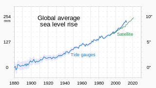
Between 1901 and 2018, average global sea level rose by 15–25 cm (6–10 in), an average of 1–2 mm (0.039–0.079 in) per year. This rate accelerated to 4.62 mm (0.182 in)/yr for the decade 2013–2022. Climate change due to human activities is the main cause. Between 1993 and 2018, thermal expansion of water accounted for 42% of sea level rise. Melting temperate glaciers accounted for 21%, while polar glaciers in Greenland accounted for 15% and those in Antarctica for 8%.

Eric J. Rignot is the Donald Bren, Distinguished and Chancellor Professor of Earth system science at the University of California, Irvine, and a Senior Research Scientist for the Radar Science and Engineering Section at NASA's Jet Propulsion Laboratory. He studies the interaction of the polar ice sheets in Greenland and Antarctica with global climate using a combination of satellite remote sensing, airborne remote sensing, understanding of physical processes controlling glacier flow and ice melt in the ocean, field methods, and climate modeling. He was elected at the National_Academy_of_Sciences in 2018.
James S. (Jay) Famiglietti is the director of the Global Institute for Water Security at the University of Saskatchewan in Saskatoon, Canada. Prior to that he was the Senior Water Scientist at NASA Jet Propulsion Laboratory in Pasadena, CA and a professor of Earth System Science at the University of California, Irvine. He is a leading expert in global water issues and in raising awareness about the global water crisis and in particular, about global groundwater depletion.

Sea ice in the Arctic region has declined in recent decades in area and volume due to climate change. It has been melting more in summer than it refreezes in winter. Global warming, caused by greenhouse gas forcing is responsible for the decline in Arctic sea ice. The decline of sea ice in the Arctic has been accelerating during the early twenty‐first century, with a decline rate of 4.7% per decade. It is also thought that summertime sea ice will cease to exist sometime during the 21st century.

Antarctic sea ice is the sea ice of the Southern Ocean. It extends from the far north in the winter and retreats to almost the coastline every summer. Sea ice is frozen seawater that is usually less than a few meters thick. This is the opposite of ice shelves, which are formed by glaciers; they float in the sea, and are up to a kilometre thick. There are two subdivisions of sea ice: fast ice, which are attached to land; and ice floes, which are not.
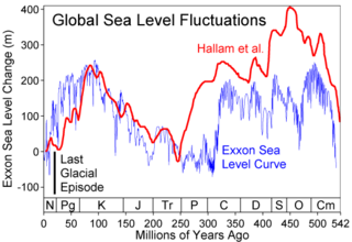
Global or eustatic sea level has fluctuated significantly over Earth's history. The main factors affecting sea level are the amount and volume of available water and the shape and volume of the ocean basins. The primary influences on water volume are the temperature of the seawater, which affects density, and the amounts of water retained in other reservoirs like rivers, aquifers, lakes, glaciers, polar ice caps and sea ice. Over geological timescales, changes in the shape of the oceanic basins and in land/sea distribution affect sea level. In addition to eustatic changes, local changes in sea level are caused by tectonic uplift and subsidence.

Robin Elizabeth Bell is Palisades Geophysical Institute (PGI) Lamont Research Professor at Columbia University's Lamont–Doherty Earth Observatory and a past President of the American Geophysical Union (AGU), 2019–2021. Dr. Bell was influential in co-ordinating the 2007 International Polar Year and was the first woman to chair the National Academy of Sciences Polar Research Board. She has made numerous important discoveries with regard to subglacial lakes and ice sheet dynamics, and has a ridge, called Bell Buttress, in Antarctica named after her.

Amelia E. Shevenell is an American marine geologist who specializes in high-latitude paleoclimatology and paleoceanography. She is currently a Professor in the College of Marine Science at the University of South Florida. She has made notable contributions to understanding the history of the Antarctic ice sheets and published in high-impact journals and, as a result, was awarded full membership of Sigma Xi. She has a long record of participation in international ocean drilling programs and has served in leadership positions of these organizations. Shevenell served as the elected Geological Oceanography Council Member for The Oceanography Society (2019-2021).

Guðfinna 'Tollý' Aðalgeirsdóttir is professor in Geophysics at the Faculty of Earth Sciences, University of Iceland.
John Matthew Wahr was an American geophysicist and geodesist, known for his research on Earth's rotation, Earth tides, ocean tides, post-glacial rebound, and other topics in the geosciences.
References
- ↑ "Velicogna CV" (PDF). Retrieved 4 August 2021.
- ↑ "Chapter 4: Observations: Cryosphere" (PDF). IPCC. Retrieved 4 August 2021.
- ↑ Velicogna, I. (2006-03-24). "Measurements of Time-Variable Gravity Show Mass Loss in Antarctica". Science. 311 (5768): 1754–1756. doi: 10.1126/science.1123785 . ISSN 0036-8075. PMID 16513944. S2CID 6373998.
- ↑ Revkin, Andrew C. (2006-03-03). "Loss of Antarctic Ice Increases". The New York Times. ISSN 0362-4331 . Retrieved 2021-08-11.
- ↑ Velicogna, I. (2009). "Increasing rates of ice mass loss from the Greenland and Antarctic ice sheets revealed by GRACE". Geophysical Research Letters. 36 (19). doi: 10.1029/2009GL040222 . ISSN 1944-8007.
- ↑ Velicogna, Isabella; Mohajerani, Yara; A, Geruo; Landerer, Felix; Mouginot, Jeremie; Noel, Brice; Rignot, Eric; Sutterley, Tyler; Broeke, Michiel van den; Wessem, Melchior van; Wiese, David (2020). "Continuity of Ice Sheet Mass Loss in Greenland and Antarctica From the GRACE and GRACE Follow-On Missions". Geophysical Research Letters. 47 (8): e2020GL087291. doi:10.1029/2020GL087291. hdl: 1874/395849 . ISSN 1944-8007. S2CID 216425228.
- ↑ Freedman, Andrew (March 18, 2020). "Greenland lost a near-record 600 billion tons of ice last summer, raising sea levels". Washington Post. ISSN 0190-8286 . Retrieved 2021-08-11.
- ↑ Hsu, Chia-Wei; Velicogna, Isabella (2017). "Detection of sea level fingerprints derived from GRACE gravity data". Geophysical Research Letters. 44 (17): 8953–8961. doi:10.1002/2017GL074070. ISSN 1944-8007. S2CID 134332890.
- ↑ Lallensack, Rachael (September 12, 2017). "Global Fingerprints of Sea Level Rise Revealed by Satellites". Scientific American. Retrieved 2021-08-11.
- ↑ Rodell, Matthew; Velicogna, Isabella; Famiglietti, James S. (2009). "Satellite-based estimates of groundwater depletion in India". Nature. 460 (7258): 999–1002. doi:10.1038/nature08238. ISSN 0028-0836. PMID 19675570. S2CID 4428681.
- ↑ A, Geruo; Velicogna, Isabella; Kimball, John S; Du, Jinyang; Kim, Youngwook; Colliander, Andreas; Njoku, Eni (1 May 2017). "Satellite-observed changes in vegetation sensitivities to surface soil moisture and total water storage variations since the 2011 Texas drought". Environmental Research Letters. 12 (5): 054006. doi: 10.1088/1748-9326/aa6965 .
- ↑ Tong, Jinjun; Velicogna, Isabella (2010-09-28). "A Comparison of AMSR-E/Aqua Snow Products with in situ Observations and MODIS Snow Cover Products in the Mackenzie River Basin, Canada". Remote Sensing. 2 (10): 2313–2322. doi: 10.3390/rs2102313 . ISSN 2072-4292.
- ↑ "Velicogna Isabella". www.nasonline.org. Retrieved 4 August 2021.
- ↑ "Vening Meinesz Medal". European Geosciences Union (EGU). Retrieved 4 August 2021.
- ↑ "Velicogna". Honors Program. Retrieved 4 August 2021.
- ↑ "Joanne Simpson Medal for Mid-Career Scientists | AGU". www.agu.org. Retrieved 4 August 2021.