Isalo National Park

Last updated
Isalo National Park
Isalo National Park Madagascar.jpg
LocationSouthwestern Madagascar
Nearest city Ranohira, Toliara and Ihosy
Coordinates 22°33.5′S45°24.0′E / 22.5583°S 45.4000°E / -22.5583; 45.4000 Coordinates: 22°33.5′S45°24.0′E / 22.5583°S 45.4000°E / -22.5583; 45.4000
Area815.40 km2 (314.83 sq mi)
Established1962 [1]
Visitors32,714(in 2011) [2]
Governing body Madagascar National Parks Association (PNM-ANGAP)

Isalo National Park is a National Park in the Ihorombe Region of Madagascar, in the southwestern corner of the Province of Fianarantsoa. The closest town is Ranohira, and the closest cities are Toliara and Ihosy. It is a sandstone landscape that has been dissected by wind and water erosion into rocky outcrops, plateaus, extensive plains and up to 200 m (660 ft) deep canyons. There are permanent rivers and streams as well as many seasonal watercourses. Elevation varies between 510 and 1,268 m (1,673 and 4,160 ft). [1] [3]

Contents

History and significance

Isalo National Park was created in 1962 and has been administered by the Madagascar National Parks authority since 1997. The Bara people have traditionally inhabited this area, a nomadic people subsisting on cattle (zebu) farming. [4] There are burial sites of the Bara people and some older burial sites of the Sakalava. [5]

Isalo is primarily within the dry deciduous forests ecoregion, an ecoregion in which natural vegetation has been reduced by almost 40% of its original extent. [6] It also includes landscapes considered part of the subhumid forests ecoregion, an ecoregion that is home to numerous endemic species and has been given Critical/Endangered status because only small areas of native habitat remain and most of those are highly fragmented. [7] The woodlands of Isalo are dominated by the endemic tree tapia ( Uapaca bojeri ). This is a woodland type that is restricted in distribution; [7] found only in Madagascar's central highlands. [8] Some of the largest intact areas of tapia woodlands are found in Isalo. [7] There are numerous narrowly endemic plant species found here, including 13 species that have been found only in Isalo and another 35 that are rare species, known from 2-5 sites. [9] Not only is Sarcolaenaceae a plant family found only in Madagascar, two species within it (Sarcolaena isaloensis and Schizolaena isaloensis) have only been found in Isalo NP. [9] There are also unusual lichens here, including the type specimen and only known location for the narrowly endemic Isalonactis madagascariensis. [10]

Climate

Isalo National Park is in the arid western part of Madagascar, within the western dry deciduous forest bioclimatic zone. The area has a hot, dry climate with two seasons; a cooler-drier season and a warmer-wetter season. Each lasts from 5–7 months. [3] Temperatures range between 15–32 °C (15–32 °C), the average annual temperature is 21.8 °C (71.2 °F) and the average rainfall is 791 millimetres (31.1 inches) (at Ranohira). Precipitation is lowest in June, averaging 2 mm (0.079 in). December thru February are typically the wettest months. Rainfall in January averages 199 millimetres (7.8 inches), [11] but the 2018/2019 wet season saw heavy rainfall, with 526 mm (20.7 in) of rain falling in January alone. [12]

Geology

Located in the southern part of the Morondava Basin, the sedimentary Isalo Group is the main geological formation of the park, forming the Isalo Massif.[ citation needed ] The group is up to 6,000m thick, of Triassic to early Jurassic origin and made up of coarse-grained sandstone deposited by braided streams. [13] The Isalo Massif has been eroded by wind and water, resulting in deep canyons, sandstone domes, flat-topped mountains and "runiform" mountains - steep sided outcrops that have been dissected into odd-shapes. These odd shapes are referred to as "runiforme", based on the French word for "carved". [5]

Tourism

A local guide is required for visitors entering the park, and guides and porters can be hired in Ranohira. Treks in the park can last from several hours to a week or longer. The park includes several natural swimming pools which are popular among tourists, and are excellent sites to see the Benson's Rock Thrush. The main threat to this park comes from illegal wildfires set in the park. The wildfires limit the extent of forest and maximize grasslands used by cattle. [14]

Fauna

Fourteen species of mammals are reported for Isalo NP, [14] including several different species of lemur.

List of lemur species found in Isalo National Park [15]
Viewing timeSpecies
Daytime
Nighttime

Over 100 species of bird have been found here, [16] including Benson's rock thrush (Monticola sharpei bensoni), the knob-billed duck (Sarkidiornis melanotos) and the Madagascar ibis (Lophotibis cristata). [14]

Twenty four amphibians and 47 reptiles have been documented in Isalo National Park, including a number of new “candidate” species. Species endemic to the Isalo area include four amphibians ( Gephyromantis azzurrae, Mantella expectata , Mantidactylus noralottae , and the Malagasy rainbow frog (Scaphiophryne gottlebei) and one reptile species ( Trachylepis nancycoutuae). [3] Notable examples include the Madagascar ground boa (Acrantophis madagascariensis), Dumeril's boa (Acrantophis dumerili) and the white-lipped bright-eyed frog (Boophis albilabris). [14]

Flora

Botanical inventory of the Isalo region began with collections by Perrier de la Bâthie in 1910. Only 10 of the over 400 species that have been documented in Isalo are non-native species. Most (over 70%) are vascular plants that are endemic to Madagascar. There are 13 species that have been found only in Isalo and another 35 are rare species, known from 2-5 sites. [9] The following table lists the species known only from Isalo NP.

Plant species found only in Isalo National Park [9]
FamilySpecies
Apocynaceae Cynanchum graminiforme
Apocynaceae Cynanchum rauhianum
Asphodelaceae Aloe isaloensis
Asteraceae Helichrysum neoisalense
Dipterocarpaceae Monotes madagascariensis
Fabaceae Crotalaria isaloensis
Fabaceae Kotschya perrieri
Fabaceae Tephrosia isaloensis
Orobanchaceae Radamaea latifolia
Podostemaceae Thelethylax isalensis
Rubiaceae Anthospermum longisepalum
Sarcolaenaceae Sarcolaena isaloensis
Sarcolaenaceae Schizolaena isaloensis

Some entire families of plants are endemic to Madagascar. Examples of three of these families can be found in Isalo; Asteropeiaceae, Sarcolaenaceae and Sphaerosepalaceae. [9] Not only is Sarcolaenaceae a plant family found only in Madagascar, two species within it (Sarcolaena isaloensis and Schizolaena isaloensis) have only been found in Isalo NP. [9]

Lichens

Dermatiscum thunbergii, a lichen on the rocks at Isalo National Park Lichens2 Isalo.jpg
Dermatiscum thunbergii, a lichen on the rocks at Isalo National Park

The lichens of Madagascar are poorly known, but over 500 species have been documented. [17] Only about 20 species are found in the dry areas of the country. Several of these have been documented in the Isalo area, [10] including the type specimen and only known location for the narrowly endemic Isalonactis madagascariensis. [10]

Vegetation

Isalo is primarily within the dry deciduous forests ecoregion, an ecoregion in which natural vegetation has been reduced by almost 40% of its original extent. [6] It also includes isolated forest patches classified as part of the subhumid forests ecoregion, an ecoregion that is home to numerous endemic species and has been given Critical/Endangered status because only small areas of native habitat remain and most of those are highly fragmented. [7] Six main habitats have been described in Isalo NP. [18]

1. Sclerophylous woodlands

The sclerophyllous (hard-leafed, drought adapted) woodlands of Isalo are dominated by the endemic tree tapia ( Uapaca bojeri ). This is a woodland type that is restricted in distribution; found only in Madagascar's central highlands. [8] Some of the largest intact areas of tapia woodlands are found in Isalo. [7] These woodlands are adapted to regular burning and are characterized by a relatively open canopy dominated primarily by tapia, but other trees may include members of the family Euphorbiaceae or the endemic family Sarcolaenaceae. The main components of the shrub layer are made up of species from the families Asteraceae, Rubiaceae, and Leguminosae, but herbs and grasses form the main understory. [18] Endemic Kalanchoe and Aloe species grow in this habitat. [7]

2. Evergreen humid forest

These forests are associated with moist habitats such as near streams or in the deep ravines. Native forests found in deep canyons have palm species ( Ravenea and Dypsis species), Breonadia salicina , Weinmannia sp., Voacanga sp. and Dracaena sp. Some of these moist habitats however are now dominated by introduced species such as Melia azedarach , Mangifera indica or Eugenia sp. [18]

3. Pandanus thickets

Pandanus thickets, dominated by Pandanus pulcher occur associated with shallower valleys or small stream are where the forest is degraded and frequently burned. [18]

4. Dry (xerophytic) vegetation

This habitat is associated with dry rocky areas, including steep slopes and ridges. Although vegetation is sparse, a number of endemic species are found in these habitats, including Xerophyta sp., elephant's foot ( Pachypodium rosulatum var. gracilius) and the narrow endemic Aloe isaloensis. [18]

5. Secondary shrub communities

Secondary shrub communities are found where the slopes of the Isalo Massif contact fields or pastures. The most common species in these communities are listed as: [18] Mimosa latispinosa, Vangueria madagascariensis , Maesa lanceolata , Aphloia theaeformis, Crotalaria sp., and Tamarindus indica .

6. Grasslands

Native grasslands, probably once restricted to small patches, are thought to have expanded as a result of intensive burning, primarily to facilitate cattle grazing. Grasslands (also called pseudo-steppes) are now widespread in Isalo, dominated by Aristida similis and Aristida rufescens [7] as well as Trachypogon sp. or Heteropogon sp. Frequent burning maintains the grasslands and prevents tree regrowth. [18]

See also

Related Research Articles

<span class="mw-page-title-main">Madagascar subhumid forests</span> Ecoregion in Central Madagascar

The Madagascar subhumid forests are a tropical moist broadleaf forest ecoregion that covers most of the Central Highlands of the island of Madagascar. They are included in the WWF's Global 200 list of outstanding ecoregions. Most of the original habitats have been lost due to human pressure.

<span class="mw-page-title-main">Madagascar ericoid thickets</span>

The Madagascar ericoid thickets is a montane shrubland ecoregion, found at higher altitudes on Madagascar's four major mountains.

<span class="mw-page-title-main">Madagascar spiny forests</span> Ecoregion in Southwest Madagascar

The Madagascar spiny forests is an ecoregion in the southwest of Madagascar. The vegetation type is found on poor substrates with low, erratic winter rainfall. The ecoregion contains an outstanding proportion of endemic plant species and is listed as one of the 200 most important ecological regions in the world; one of the Global 200.

<span class="mw-page-title-main">Madagascar dry deciduous forests</span> Tropical dry forest ecoregion in Madagascar

The Madagascar dry deciduous forests represent a tropical dry forest ecoregion situated in the western and northern part of Madagascar. The area has high numbers of endemic plant and animal species but has suffered large-scale clearance for agriculture. They are among the world's richest and most distinctive dry forests and included in the Global 200 ecoregions by the World Wide Fund. The area is also home to distinctive limestone karst formations known as tsingy, including the World Heritage Site of Bemaraha.

<span class="mw-page-title-main">Marojejy National Park</span> National park in the Sava region of northeastern Madagascar

Marojejy National Park is a national park in the Sava region of northeastern Madagascar. It covers 55,500 ha (214 sq mi) and is centered on the Marojejy Massif, a mountain chain that rises to an elevation of 2,132 m (6,995 ft). Access to the area around the massif was restricted to research scientists when the site was set aside as a strict nature reserve in 1952. In 1998, it was opened to the public when it was converted into a national park. It became part of the World Heritage Site known as the Rainforests of the Atsinanana in 2007. "Unique in the world, a place of dense, jungly rainforests, sheer high cliffs, and plants and animals found nowhere else on earth", Marojejy National Park has received plaudits in the New York Times and Smithsonian Magazine for its natural beauty and rich biodiversity that encompasses critically endangered members of the silky sifaka. To that end, a global consortium of conservation organizations, including the Lemur Conservation Foundation, Duke Lemur Center and Madagascar National Parks, have sought to promote research and conservation programs in Marojejy National Park, neighboring Anjanaharibe-Sud Reserve and Antanetiambo Private Reserve, to protect the endemic flora and fauna that reside in northeastern Madagascar. In addition, these organizations have implemented a variety of community-based initiatives to mitigate human encroachment on the park, such as poaching and selective logging, by encouraging local communities to engage in afforestation and silvicultural initiatives to promote a sustainable alternative to mining, slash-and-burn agriculture, and wood collection.

<span class="mw-page-title-main">Tsimanampetsotsa National Park</span>

Tsimanampetsotsa National Park also spelt Tsimanampetsotse, and known as Tsimanampetsotsa Nature Reserve is a 432 km2 national park on the south-west coast of Madagascar in the region Atsimo-Andrefana. The park is 90 kilometres (56 mi) south of Toliara and 950 kilometres (590 mi) south of the capital, Antananarivo. Route Nationales (RN) 10 to Faux Cap passes the park and the nearest airport is at Toliara. The national park contains and is named after Lake Tsimanampetsotsa.

<span class="mw-page-title-main">Zombitse-Vohibasia National Park</span>

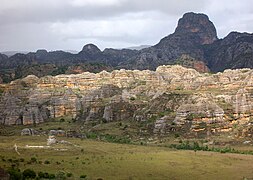
Zombitse-Vohibasia is a national park in the Atsimo-Andrefana region of south-west Madagascar. It is 147 kilometres (91 mi) north-east of the town of Toliara, the site of the nearest airport, and the Welcome Office is at Sakaraha 10 kilometres (6.2 mi) from the park entrance. The park covers a surface of 36,308 hectares on three sites; the forest of Zombitse and the sites of Isoky Vohimena and Vohibasia. The Bara people and Mahafaly people are the main ethnic groups in the area.

Ambohijanahary Special Reserve is a wildlife reserve in the regions of Menabe and Melaky in Madagascar. The reserve was created in 1958 to protect the sclerophyllous forest between Tsiroanomandidy and Maintirano, as well as protecting the many endemic species of plants and animals.

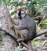
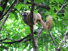
Mangerivola Special Reserve is a wildlife reserve in the east of Madagascar. It was established in 1958 and is a hotspot for bird-watchers due to the one hundred species found there, including 63 endemics and many local endemics. There are also seven species of lemur and rare chameleons such as the Lance-nosed chameleon which is registered as endangered on the IUCN Red List of Threatened Species.

<span class="mw-page-title-main">Flora of Madagascar</span> Plants endemic to Madagascar

The flora of Madagascar consists of more than 12,000 species of plants, as well as a poorly known number of fungi and algae. Around 83% of Madagascar's vascular plants are found only on the island. These endemics include five plant families, 85% of the over 900 orchid species, around 200 species of palms, and such emblematic species as the traveller's tree, six species of baobab and the Madagascar periwinkle. The high degree of endemism is due to Madagascar's long isolation following its separation from the African and Indian landmasses in the Mesozoic, 150–160 and 84–91 million years ago, respectively. However, few plant lineages remain from the ancient Gondwanan flora; most extant plant groups immigrated via across-ocean dispersal well after continental break-up.

<i>Uapaca bojeri</i> Species of tree

Uapaca bojeri, or tapia, is a tree species endemic to Madagascar. A characteristic element of the Madagascan flora, it occurs in the central highlands, where it dominates a type of sclerophyllous forest or woodland. Tapia forest has a high ecological value due to the fauna and flora it harbours, and is of economic interest to the local population, e.g. for collection of tapia fruits, firewood, mushrooms or wild silkworms, and hunting. Local impact through fire and cutting is seen as a form of sustainable use however tapia woodlands are now found only in scattered, isolated stands totaling at most 132,255 ha. Native woody vegetation of the central highlands is increasingly replaced by grasslands, primarily due to increased fire frequency as areas are burned annually.

<span class="mw-page-title-main">Madagascar succulent woodlands</span>

The Madagascar succulent woodlands are a xeric shrublands ecoregion in southwestern and central western Madagascar. Native plants survive in the arid climate and long dry season with adaptations like succulent leaves, water storing trunks, photosynthetic stems, and dropping leaves during the dry season. The ecoregion is threatened by various human activities.

Schizolaena isaloensis is a tree in the family Sarcolaenaceae. It is endemic to Madagascar. The specific epithet refers to Isalo National Park, near where the species was identified.

Perrierodendron quartzitorum is a plant in the family Sarcolaenaceae. It is endemic to Madagascar.

Little work has been done on the lichens of Madagascar, so while over 500 species of lichens have been documented, more are expected. Madagascar can be divided into two major habitats that can be associated with lichen distribution. Wet tropical areas of siliceous bedrock make up approximately two-thirds of the country, and are where most of the lichens have been documented. Dry tropical areas of granitic and limestone bedrock make up the other one-third of the country with just over 20 species documented in these habitats. The following table lists the species known from the dry tropical habitats. The majority are corticolous species that grow on the bark of trees or shrubs. A few are saxicolous; species that grow on rocks.

<i>Borocera cajani</i> Species of moth

Borocera cajani, also known as landibe in Malagasy, is a species of silk-producing lasiocampid moth endemic to Madagascar. It is often confused with the similar Borocera madagascariensis, which has the same Malagasy name. However, B. cajani is the species associated with silk production in highland Madagascar, while B. madagascariensis is found in the coastal portion of the island.

Isalonactis is a monotypic fungal genus in the family Roccellaceae. It contains the single species Isalonactis madagascariensis, a saxicolous (rock-dwelling), crustose lichen found in Madagascar. Both the genus and species were described as new in 2014 by Damien Ertz, Anders Tehler, Eberhard Fischer, Dorothee Killmann, Tahina Razafindrahaja, and Emmanuël Sérusiaux. The type was collected on the Isalo Massif at an altitude of 851 m (2,792 ft); there, it was found growing on sheltered mesozoic sandstone cliffs. The genus name alludes to both Isalo Massif, the type locality, and the phylogenetic relatedness to genus Lecanactis.

Analavelona, also known as Analavelona Massif, is a mountain in southwestern Madagascar. The massif is home to an enclave of montane subhumid forest, which is considered a sacred forest by the local people and notable for its biodiversity.

The Sambirano region, also known as the Sambirano domain, is a biogeographic region of northwestern Madagascar. It has a distinctive lowland climate with year-round rain, differing from the rest of seasonally-dry western and northern Madagascar. The climate supports humid lowland rainforests, with greater similarity to those of eastern Madagascar than the dry deciduous forests characteristic of the Madagascar's western lowlands.

References

  1. 1 2 "Madagascar National Parks". Madagasikara National Parks. 2014. Retrieved 13 September 2014.
  2. "Plus de 255.000 touristes à Madagascar en 2012". Linfo.re. Antenne Reunion Télévision. Retrieved 2023-02-24.
  3. 1 2 3 Cocca, W.; Rosa, G. M.; Andreone, F.; Aprea, G.; Eusebio, Bergò P.; Mattioli, F.; Mercurio, V.; Randrianirina, J. E.; Rosado, D.; Vences, M.; Crottini, A. (2018). "The herpetofauna (Amphibia, Crocodylia, Squamata, Testudines) of the Isalo Massif, Southwest Madagascar: combining morphological, molecular and museum data" (PDF). Salamandra. 54 (3): 178–120. S2CID   53350797. Archived from the original (PDF) on 2019-03-07.
  4. Bradt, Hilary; Austin, Daniel (2007). Madagascar (9th ed.). The Globe Pequot Press. pp. 113–115. ISBN   978-1-84162-197-5.
  5. 1 2 Schuurman, D.; Ravelojaona, N. (2013). Madagascar (4 ed.). Globetrotter Travel Guide; New Holland Publishers.
  6. 1 2 Waeber, P.O.; Wilmé, L.; Ramamonjisoa, B.; Garcia, C.; Rakotomalala, D.; Rabemananjara, Z.H.; Kull, C.A.; Ganzhorn, J.U.; Sorg, J.-P. (2015). "Dry forests in Madagascar: neglected and under pressure". International Forestry Review. 17 (2): 126–147. doi:10.1505/146554815815834822. S2CID   153544029.
  7. 1 2 3 4 5 6 7 "Southern Africa: Central Madagascar | Ecoregions | WWF".
  8. 1 2 Alvarado, S. T.; Buisson, E.; Rabarison, H.; Birkinshaw, C.; Lowry, P. P. (2012). "Ibity Mountain, Madagascar: Background and Perspectives for Ecological Restoration". Ecological Restoration. 30: 12–15. doi:10.3368/er.30.1.12. S2CID   84615363.
  9. 1 2 3 4 5 6 Goodman, S. M.; Raherilalao, M. J.; Wohlhauser, S., eds. (2018). Les aires protégées terrestres de Madagascar: Leur histoire, description et biote[The terrestrial protected areas of Madagascar: Their history, description, and biota] (in French). Antananarivo: Association Vahatra.
  10. 1 2 3 Ertz, D.; Fischer, E.; Killmann, D.; Razafindrahaja, T.; Sérusiaux, E. (2014). "Isalonactis, a new genus of Roccellaceae (Arthoniales), from southern Madagascar". The Lichenologist. 46 (2): 159–167. doi:10.1017/S002428291300090X. S2CID   258994.
  11. "Climate Ranohira (Madagascar)". Climate-Data.org.
  12. "World Weather Online". World Weather Online.
  13. Wescott, William, A.; John, N. Diggens (1998). "Depositional history and stratigraphical evolution of the Sakamena group (Middle Karoo Supergroup) in the southern Morondava Basin, Madagascar". Journal of African Earth Sciences . 27 (3–4): 461–479. Bibcode:1998JAfES..27..461W. doi:10.1016/S0899-5362(98)00073-6.
  14. 1 2 3 4 "Isalo" (in French). Madagascar National Parks. Archived from the original on 2012-02-12. Retrieved 2013-12-07.
  15. Mittermeier, R.A.; Louis, E.E.; Richardson, M.; Schwitzer, C.; et al. (2010). Lemurs of Madagascar . Illustrated by S.D. Nash (3rd ed.). Conservation International. p. 647. ISBN   978-1-934151-23-5. OCLC   670545286.
  16. "eBird". eBird.org. Archived from the original on 2019-07-02. Retrieved 2019-07-02.
  17. Aptroot, André (2016). "Preliminary checklist of the lichens of Madagascar, with two new thelotremoid Graphidaceae and 131 new records". Willdenowia . 46 (3): 349–366. doi: 10.3372/wi.46.46304 .
  18. 1 2 3 4 5 6 7 Świerkosz, Krzysztof (2012). "Vegetation of southern part of the Isalo Sandstone Massif (Central Madagascar, Africa) – differentiation and threats". In Hartel H.; Cilek V.; Hebren T. A. Jackson; R. Williams (eds.). Sandstone Landscapes. doi:10.6084/m9.figshare.92596.