
Madhya Pradesh is a state in central India. Its capital is Bhopal, and the largest city is Indore, with Gwalior, Jabalpur, Ujjain, Dewas, Sagar, Satna, and Rewa being the other major cities. Madhya Pradesh is the second largest Indian state by area and the fifth largest state by population with over 72 million residents. It borders the states of Uttar Pradesh to the northeast, Chhattisgarh to the east, Maharashtra to the south, Gujarat to the west, and Rajasthan to the northwest.

Indore is the largest and most populous city in the Indian state of Madhya Pradesh. It is consistently ranked as the cleanest city in India. It serves as the headquarters of both the Indore District and the Indore Division. It is also considered as the state education hub and houses campuses of both the Indian Institute of Technology and the Indian Institute of Management. Located on the southern edge of Malwa Plateau, at an average altitude of 553 meters (1,814 ft) above sea level, it has the highest elevation among major cities of Central India. The city is 190 km (120 mi) west of the state capital of Bhopal. It is 57 km from Ujjain and 35 kms from Dewas. Indore had a census-estimated 2011 population of 1,994,397 and 3,570,295. The city is distributed over a land area of just 530 square kilometres (200 sq mi), making Indore the most densely populated major city in the central province.

Pachmarhi is a hill station in the Narmadapuram district of Madhya Pradesh state of central India. It has been the location of a cantonment since British Raj.

Mhow, officially Dr. Ambedkar Nagar, is a town in the Indore district in Madhya Pradesh state of India. It is located 23 kilometres (14 mi) south-west of Indore city, towards Mumbai on the old Mumbai-Agra Road. The town was renamed as Dr. Ambedkar Nagar in 2003, by the Government of Madhya Pradesh.
Harda is a town and a municipality in Harda district in the Indian state of Madhya Pradesh. Harda is the administrative headquarters of Harda.
Ratlam is a city in the northwestern part of the Malwa region in Madhya Pradesh state of India. The city of Ratlam lies 480 metres (1,570 ft)above sea level. It is the administrative headquarters of Ratlam district, which was created in 1947 after the independence of India. It is located 294 kilometres west of the state capital Bhopal.
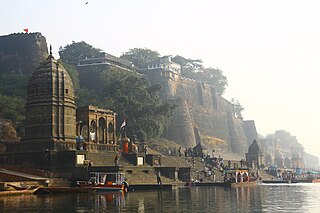
Maheshwar is a town, near Khargone city in Khargone district of Madhya Pradesh state, in central India. It is located on State Highway-38 ,13.5 km east of National Highway 3 and 91 km from Indore, the commercial capital of the state. The Town lies on the north bank of the Narmada River. It was the kingdom of Chaktavartin Samrat Sahastraarjun, Kartavirya Arjuna a Heheya king. Lately, after many years, it was the capital of the Malwa during the Maratha Holkar reign till 6 January 1818, when the capital was shifted to Indore by Malhar Rao Holkar III.

Omkareshwar is a Hindu temple dedicated to Shiva, located in Mandhata, nearby Khandwa city in Khandwa district of the Indian state of Madhya Pradesh. It is one of the 12 revered Jyotirlinga shrines of Shiva. It is on an island called Mandhata, near Khandwa city in the Narmada river at Khandwa district in Madhya Pradesh, India; the shape of the island is said to be like the Devanagari ॐ symbol.
Ashoknagar is a city and a Municipality Council in Ashoknagar District in Madhya Pradesh state of central India. It is the administrative headquarters of Ashoknagar District. Earlier it was part of Guna district. Ashoknagar is well known for its Grain Mandi and "Sharbati Gaihu", a type of wheat. The nearest city Guna 45 km from the city. Ashoknagar was formerly known as Pachar. The railway line passes from the middle of the city. Ashoknagar has a railway station and Two Bus stations. Ashoknagar is connected to the main cities of Madhya Pradesh by road and railway.

Dewas District is a district in the Indian state of Madhya Pradesh. The town of Dewas is the district headquarters.
Ashoknagar District is a district of Madhya Pradesh state in central India. The city of Ashoknagar is the administrative headquarters of the district. Ashoknagar district was formed in 2003.

The Indore District is a district of Madhya Pradesh state in central India. It is believed that the city is named after its Indreshwar Mahadev Temple, Where Indra is the presiding deity. The Gupta inscriptions name Indore as "Indrapura". It is also called the administrative capital. This district forms part of the Indore Division.
Tourism in Madhya Pradesh has been an attraction of India because of its location in the centre of the country. Madhya Pradesh has won Best Tourism State National award for 3 consecutive years i.e. 2017, 2016 and 2015.

The economy of Madhya Pradesh refers to the economic growth with respect to the Indian state of Madhya Pradesh. It grew 12% in GDP for the year of 2011–12, for which it received an award from the President Pranab Mukherjee in January 2013 for improving its tourism, medical and infrastructural growth. The economy of Madhya Pradesh is significantly agrarian which is reflecting rapid strides towards industrial and service sectors as well. The Indore, Bhopal and Jabalpur districts are the top 3 districts in terms of highest output generation in the state's economy.

Nemawar is a small town in Dewas District, Madhya Pradesh, India. Nemawar is located on the left bank of the Narmada river opposite to Handia. However, it belongs to Khategaon block and tehsil of the Dewas district
Parshuram Temple is a temple of Lord Parshurama, the sixth avatar of Vishnu in Hinduism located near Chiplun in Ratnagiri district of Maharashtra, India.
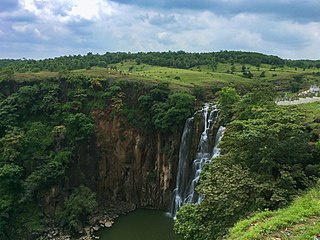
The Patalpani Waterfall is a waterfall on the Choral River, a tributary of the Narmada, located in the Mhow Tehsil of Indore district in the state of Madhya Pradesh, India.

Tourism in India is economically important and ever-growing. The World Travel & Tourism Council calculated that tourism generated ₹14.02 lakh crore (US$180 billion) or 9.6% of the nation's GDP in 2016 and supported 40.343 million jobs, 9.3% of its total employment. The sector is predicted to grow at an annual rate of 6.8% to ₹28.49 lakh crore (US$360 billion) by 2027. Various states and union territories of India attract tourists from all over the world, mainly due to the cultural diversity.
Bhatkhedi is a Gram Panchayat under sub-division Dr. Ambedkar Nagar (Mhow) in Indore district in the Indian state of Madhya Pradesh. Total geographical area of Bhatkhedi gram panchayat is 9 km2. Mhowgaon is nearest town to Bhatkhedi which is approximately 7 km away.
Madhya Pradesh State Highway 1 is State Highway running from Rau till Mandleshwar. It is popularly known as Mhow-Mandleshwar Road.


