Related Research Articles

Azad Jammu and Kashmir abbreviated as AJK and colloquially referred to as simply Azad Kashmir, is a region administered by Pakistan as a nominally self-governing entity and constituting the western portion of the larger Kashmir region, which has been the subject of a dispute between India and Pakistan since 1947. Azad Kashmir also shares borders with the Pakistani provinces of Punjab and Khyber Pakhtunkhwa to the south and west, respectively. On its eastern side, Azad Kashmir is separated from the Indian union territory of Jammu and Kashmir by the Line of Control (LoC), which serves as the de facto border between the Indian- and Pakistani-controlled parts of Kashmir. Geographically, it covers a total area of 13,297 km2 (5,134 sq mi) and has a total population of 4,045,366 as per the 2017 national census.

Pahari-Pothwari is an Indo-Aryan language variety of Lahnda group, spoken on the Pothohar Plateau in the far north of Punjab, Pakistan, as well as in most of Pakistan-administered Azad Kashmir and in western areas of Indian-administered Jammu and Kashmir, is known by a variety of names, the most common of which are Pahari, and Pothwari.
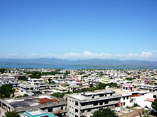
Mirpur, officially known as New Mirpur City, is the capital of Mirpur district located in Azad Kashmir, Pakistan which has been subject of the larger Kashmir dispute between Pakistan and India since 1947. It is the second largest city of Azad Kashmir and the 74th largest city in Pakistan.

Bhimber District is a district of Pakistan-administered Azad Kashmir in the disputed Kashmir region. It is the southernmost of the 10 districts of Pakistan's territory of Azad Kashmir. It has an area of 1,516 km², and the district headquarter is the town of Bhimber.

Kotli District is a district of Pakistan-administered Azad Kashmir in the Azad Kashmir region. It is one of the 10 districts of Pakistan's dependent territory of Azad Kashmir. It is bounded on the north by the Sudhanoti District and the Poonch District, on the north-east by the Poonch District of Indian-administered Jammu and Kashmir, on the south by the Mirpur and Bhimber districts, and on the west by the Rawalpindi District on Pakistan's Punjab Province. Kotli is the biggest district of Azad Kashmir by population and the second biggest by land area, after the Neelum District. The district headquarters is the city of Kotli. The main native languages are Pahari, and Gujari.

Mirpur District is a district of Pakistan-administered Azad Kashmir in the disputed Kashmir region. It is one of the 10 districts of Pakistan's territory of Azad Kashmir. The Mirpur District is bounded on the north by the Kotli District, on the east by the Bhimber District, on the south by the Gujrat District of Punjab, Pakistan, on the south-west by the Jhelum District of Punjab, Pakistan, and on the west by its Rawalpindi District. The district is named after its main city, Mirpur. The Mirpur District has a population of 456,200 and covers an area of 1,010 km2 (390 sq mi). The district is mainly mountainous with some plains. The Mirpur District has a humid subtropical climate which closely resembles that of the Gujrat District and the Jhelum District, the adjoining districts of Pakistan's Punjab Province.
The British Mirpuri community comprises people in the United Kingdom who originate from the Mirpur District and surrounding areas in Pakistan-administered Azad Jammu and Kashmir, thus being a part of the Mirpuri diaspora. While no accurate statistics are available, an estimated 60 to 70 per cent of British Pakistanis in England trace their origins to the administrative territory of Azad Kashmir in northeastern Pakistan, mainly from the Mirpur, Kotli and Bhimber districts.

Haryanvi is an Indo-Aryan language spoken primarily in the Indian state of Haryana and the territory of Delhi. Haryanvi is considered to be part of the dialect group of Western Hindi, which also includes Khariboli and Braj. It is written in the Devanagari script.
Khuiratta or Khoi ratta is a Tehsil in Kotli District, in Pakistan-administered Azad Kashmir.
Gulpur is a town in the Kotli District of Azad Kashmir, Pakistan. It is located at 33°26'5N 73°51'40E. It is located southwest of Kotli city and is located on the junction of the Kotli-Mirpur and Kotli-Rawalpindi road. Gulpur is a small town providing for the local villages as well as the residents of a large refugee camp.
Rajdhani is a union council in the Kotli District, Azad Kashmir, 40 kilometres (25 mi) west of the city of Kotli, the capital of the Kotli District and 64 kilometres (40 mi) north of Azad Kashmir's rapidly expanding model city of Mirpur. The Kotli-Mirpur Main Road passes through the village.
Islamgarh, known previously as Akalgarh is a tehsil and Municipal Committee of Mirpur District near Mangla Dam of Azad Jammu and Kashmir. It is located on the southern part of the Pir Panjal Range, about 28 Kilometer in North-East of Mirpur. It had a population of 175,651 in 2023.
The demographics of Rawalpindi District, a district of Punjab in Pakistan, has undergone significant changes over the years. It has been affected by turmoil in the surrounding districts.
Hajira is a small town in Poonch District of Azad Kashmir, Pakistan. It is the headquarters of Tehsil Hajira also known as 'Cheara' in local accents. Hajira is a transport hub, being the center point of different districts. Hajira Ponch is correctly interpreted as ‘Hajira Reach’. In front (South) of Hajira there is district Sudhnoti. On the left side of Hajira there is district Kotli. On the back side (North) of Hajira there is district 'Haveli. District Bagh is in the right side (West) of Hajira. Khai Gala and Rawalakot are the other nearest cities of Hajira and located in the right side (West) of Hajira. While summers can be very hot the winters are mild in Hajira, with snowfall very rare due to the low altitude. The language spoken in Hajira is Urdu similar to the right west side of Hajira as Rawlakot, as you go north to Tata pani towards Kotli and Mirpur the language emerges in to “Pahari” and “Potwari”. Hajira is close to Indian borders hence the main language becoming Urdu. The Indian borders and line of control LOC is near Hajira.
The Kashmiri diaspora refers to Kashmiris who have migrated out of the Kashmir into other areas and countries, and their descendants.
The Mirpuri diaspora constitutes individuals with an origin in the Mirpur District of Azad Kashmir, Pakistan, now living outside that district. Migration from Mirpur started occurring in the 1920s, when many Mirpuris left for Bombay to work on merchant ships. During the partition of British India in 1947, many Mirpuri Hindus and Mirpuri Sikhs were forced to flee to cities in the princely state of Jammu and Kashmir. The construction of the Mangla Dam by the Pakistani Government in the 1960s caused many of Mirpuri Muslims to migrate to the United Kingdom to work as labourers.

The Mirpur Division is a first-order administrative division of the Pakistani dependent territory of Azad Kashmir. Mirpur is the largest division by population in Azad Kashmir. It comprises the portion of the former Mirpur District of the princely state of Jammu and Kashmir that came under Pakistani control at the end of the Indo-Pakistani War of 1947.
Charhoi is a tehsil of Kotli District, Azad Kashmir, Pakistan. It is the largest city in Kotli district and is the headquarters of the district subdivision. A shrine of the poet Mian Muhammad Bakhsh is about 5 kilometers away from the main bazaar. Charhoi has a police station, post office, 3 big Jamia masjids and a 50 beds tehsil headquarter hospital, Charhoi Gala is main entrance of Charhoi city. Batowa, new batowa,Narakot, Chahwala, Dahmal Bazar, Damas and meda town is creation of a man name Juna Khanka Kotera, Sanyah are the main places around Charhoi. Charhoi is situated some 50 kilometers away from Mirpur City and around 30 kilometers from Khuiratta. Dahmal Nursery is a lush green place some 5 kilometers away, towards Khuiratta.
Jatki/Jattki bascically means the language or dielect of Panjabi Jats of Bar region
Jhangar or Jhanger is a village in the Rajouri district of Indian-administered Jammu and Kashmir, close to the Line of Control that divides the Indian and Pakistan-administered portions of Kashmir.
References
- ↑ "Rawalpindi District (Pothohar Plateau)". Digital South Asia Library - Imperial Gazetteer of India v.21, page 266. Retrieved 24 December 2022.