Joinville Island group

Last updated

Joinville Island group
JoinvilleIsland Terra MODIS.jpg
Satellite picture of the group
Antarctica location map.svg
Red pog.svg
Joinville Island group
Geography
Location Antarctica
Coordinates 63°15′S55°45′W / 63.250°S 55.750°W / -63.250; -55.750 (Joinville Island group)
ArchipelagoJoinville Island group
Administration
Administered under the Antarctic Treaty System
Demographics
PopulationUninhabited

Joinville Island group is a group of antarctic islands, lying off the northeastern tip of the Antarctic Peninsula, from which Joinville Island group is separated by the Antarctic Sound. [1] [2] [3]

Contents

Location

Trinity Peninsula on Antarctic Peninsula. Joinville Island group to the north Trinity Peninsula.svg
Trinity Peninsula on Antarctic Peninsula. Joinville Island group to the north
Joinville Island group: D'Urville Island (3) - Joinville Island (4) - Dundee Island (5) - Bransfield Island (14) Wfm antarctic peninsula islands.png
Joinville Island group: D'Urville Island (3) – Joinville Island (4) – Dundee Island (5) – Bransfield Island (14)

The Joinville Island group lies in Graham Land to the east of the tip of Trinity Peninsula, which is itself the tip of the Antarctic Peninsula. It is separated from the mainland by the Antarctic Sound. Joinville Island is at the center of the group. Other islands and rocks include, clockwise from the west, Bransfield Island, D'Urville Island, Wideopen Islands, Brash Island, Danger Islands, Eden Rocks, Paulet Island, Dundee Island. [4]

Main islands

D'Urville Island

63°05′S56°20′W / 63.083°S 56.333°W / -63.083; -56.333 . Northernmost island of the Joinville Island group, 17 nautical miles (31 km; 20 mi) long, lying immediately north of Joinville Island, from which it is separated by Larsen Channel. Charted in 1902 by the SwedAE under Otto Nordenskjöld, who named it for Captain Jules Dumont d'Urville, French explorer who discovered land in the Joinville Island group. [5]

Joinville Island

63°15′S55°45′W / 63.250°S 55.750°W / -63.250; -55.750 . Largest island of the Joinville Island group, about 40 nautical miles (74 km; 46 mi) long in an east–west direction and 12 nautical miles (22 km; 14 mi) wide, lying off the northeast tip of Antarctic Peninsula, from which it is separated by Antarctic Sound. Discovered and roughly charted in 1838 by a French expedition under Captain Jules Dumont d'Urville, who named it for François d'Orléans, Prince of Joinville (1818-1900), the third son of the Due d'Orleans. [6]

Dundee Island

63°30′S55°55′W / 63.500°S 55.917°W / -63.500; -55.917 . Ice-covered island lying east of the northeast tip of Antarctic Peninsula and south of Joinville Island. Discovered on January 8, 1893 by Captain Thomas Robertson of the Active and named for the home port, Dundee, Scotland, from whence the ship sailed in company with three other vessels in search of whales. [7]

Straits

Antarctic Sound

63°20′S56°45′W / 63.333°S 56.750°W / -63.333; -56.750 . Body of water about 30 nautical miles (56 km; 35 mi) long and from 7 to 12 nautical miles (13 to 22 km; 8.1 to 13.8 mi) wide, separating the Joinville Island group from the northeast end of the Antarctic Peninsula. The sound was named by the Swedish Antarctic Expedition (SwedAE) under Otto Nordenskjöld for the expedition ship Antarctic which in 1902, under the command of Captain C.A. Larsen, was the first vessel to navigate it. [8]

Burden Passage

63°08′S56°32′W / 63.133°S 56.533°W / -63.133; -56.533 . A marine passage between D'Urville Island and Bransfield Island. Charted in 1947 by the FIDS and named after Eugene Burden (1892-1979), who, as master of the Trepassey, first navigated the passage in January 1947. [9]

Larsen Channel

63°10′S56°12′W / 63.167°S 56.200°W / -63.167; -56.200 . A strait 1 to 3 nautical miles (1.9 to 5.6 km; 1.2 to 3.5 mi) wide between D'Urville Island and Joinville Island. Discovered in 1902 by the Swedish Antarctic Expedition under Nordenskjold, and named for Captain C.A. Larsen of the expedition ship Antarctic. [10]

Firth of Tay

63°22′S55°45′W / 63.367°S 55.750°W / -63.367; -55.750 . A sound, 12 nautical miles (22 km; 14 mi) long and 6 nautical miles (11 km; 6.9 mi) wide, extending in a northwest–southeast direction between the northeast side of Dundee Island and the east portion of Joinville Island. It merges to the northwest with Active Sound with which it completes the separation of Dundee and Joinville Islands. Discovered in 1892–93 by Captain Thomas Robertson of the Dundee whaling expedition and named by him after the Firth of Tay of Scotland. [11]

Active Sound

63°25′S56°10′W / 63.417°S 56.167°W / -63.417; -56.167 . A sound, averaging 2 nautical miles (3.7 km; 2.3 mi) wide, extending in an east-northeast direction from Antarctic Sound and joining the Firth of Tay with which it separates Joinville and Dundee Islands. Discovered in 1892-93 by Captain Thomas Robertson of the Dundee whaling expedition. Robertson named the feature after his ship, the Active, first vessel to navigate the sound. [12]

Smaller islands

Smaller islands, clockwise from the west, include:

Bransfield Island

Bransfield Island, October 27, 2016 Bransfield Island (30724544742).jpg
Bransfield Island, October 27, 2016

63°11′S56°36′W / 63.183°S 56.600°W / -63.183; -56.600 . An island nearly 5 nautical miles (9.3 km; 5.8 mi) |long, lying 3 nautical miles (5.6 km; 3.5 mi) southwest of D'Urville Island. The name Point Bransfield, after Edward Bransfield, Master, Royal Navy, was given in 1842 by a British expedition under James Clark Ross to the low western termination of what is now the Joinville Island group. A 1947 survey by the FIDS determined that this western termination is a separate island. [13]

Papua Island

63°07′S55°57′W / 63.117°S 55.950°W / -63.117; -55.950 . A small circular island lying 4 nautical miles (7.4 km; 4.6 mi) west of Boreal Point, off the north coast of Joinville Island. The name was applied by the Argentine Antarctic Expedition (1953-54) because large numbers of gentoo penguins (Pygoscelis papua) were sighted on this island. [14]

Wideopen Islands

63°00′S55°49′W / 63.000°S 55.817°W / -63.000; -55.817 . A group of islands and rocks lying 7 nautical miles (13 km; 8.1 mi) north of Boreal Point, Joinville Island. Roughly surveyed from a distance by the FIDS in 1953-54. So named by the UK Antarctic Place-Names Committee (UK-APC) in 1958 because of their exposed, isolated position on the south side of Bransfield Strait. [15]

Patella Island

63°08′S55°29′W / 63.133°S 55.483°W / -63.133; -55.483 . A small but prominent island, more than 75 metres (246 ft) high, lying 2 nautical miles (3.7 km; 2.3 mi) northwest of Ambush Bay off the north coast of Joinville Island. Surveyed by the Falkland Islands Dependencies Survey (FIDS) in 1953. The name is descriptive of the island's shape; Patella is the Latin name for a limpet. [16]

Etna Island

63°05′S55°09′W / 63.083°S 55.150°W / -63.083; -55.150 . An island with a high summit, lying 6 nautical miles (11 km; 6.9 mi) north of the eastern end of Joinville Island. Discovered by a British expedition under James Clark Ross, 1839-43, who so named it because of its resemblance to volcanic Mount Etna. [17]

Brash Island

63°24′S54°55′W / 63.400°S 54.917°W / -63.400; -54.917 . An isolated island lying 5 nautical miles (9.3 km; 5.8 mi) northwest of Darwin Island, off the southeast end of Joinville Island. Surveyed by the FIDS in 1953. So named by the UK-APC because the island lies in an area where brash ice is frequently found. [13]

Danger Islands

63°25′S54°40′W / 63.417°S 54.667°W / -63.417; -54.667 . Group of islands lying 13 nautical miles (24 km; 15 mi) east-southeast of Joinville Island. Discovered December 28, 1842 by a British expedition under James Clark Ross, who so named them because, appearing among heavy fragments of ice, they were almost completely concealed until the ship was nearly upon them. [18]

Puget Rock

63°29′S55°39′W / 63.483°S 55.650°W / -63.483; -55.650 . A rock lying east of Eden Rocks, off the east end of Dundee Island. The name Cape Puget was given by Sir James Clark Ross on December 30, 1842, for Captain William D. Puget, Royal Navy, but it is not clear from Ross' text what feature he was naming. The name Puget Rock was given by the UK Antarctic Place-Names Committee (UK-APC) in 1956 in order to preserve Ross' name in this vicinity. [19]

Eden Rocks

63°29′S55°40′W / 63.483°S 55.667°W / -63.483; -55.667 . Two rocks lying just off the east end of Dundee Island. A small island was reported here by Captain James Clark Ross, Royal Navy, on December 30,1842. He named it "Eden Island" for Captain Charles Eden, Royal Navy. Following survey by the Falkland Islands Dependencies Survey (FIDS) in 1953, it was reported that the feature consists of two rocks lying close together. [20] The Eden Rocks are a designated Important Bird Area. [21]

Paulet Island

63°35′S55°47′W / 63.583°S 55.783°W / -63.583; -55.783 . A circular island about 1 nautical mile (1.9 km; 1.2 mi) in diameter, lying 3 nautical miles (5.6 km; 3.5 mi) southeast of Dundee Island. Discovered by a British expedition under Ross, 1839-43, and named by him for Captain the Right Honorable Lord George Paulet. [22]

Rosamel Island

63°34′S56°17′W / 63.567°S 56.283°W / -63.567; -56.283 . A circular island 1 nautical mile (1.9 km; 1.2 mi) in diameter with precipitous cliffs of volcanic rock rising to a snow-covered peak 435 metres (1,427 ft) high high, lying west of Dundee Island in the south entrance to Antarctic Sound. Discovered by the French expedition, 1837-40, under Captain Jules Dumont d'Urville, and named by him for V. Admiral Claude de Rosamel, French Minister of Marine under whose orders the expedition sailed. [23]

Related Research Articles

<span class="mw-page-title-main">Thurston Island</span> Island in Ellsworth Land, Antarctica

Thurston Island is a largely ice-covered, glacially dissected island, 135 nautical miles long and 55 nautical miles wide, lying between between Amundsen Sea and Bellingshausen Sea a short way off the northwest end of Ellsworth Land, Antarctica. The island is separated from the mainland by Peacock Sound, which is occupied by the west portion of Abbot Ice Shelf.

<span class="mw-page-title-main">Dundee Island</span> Island at the tip of the Antarctic Peninsula

Dundee Island is an ice-covered island lying east of the northeastern tip of the Antarctic Peninsula and south of Joinville Island, Antarctica.

<span class="mw-page-title-main">Joinville Island</span> Island of Antarctica

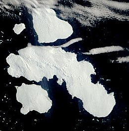
Joinville Island is the largest island of the Joinville Island group, about 40 nautical miles long in an east–west direction and 12 nautical miles wide, lying off the northeastern tip of the Antarctic Peninsula, from which it is separated by the Antarctic Sound.

<span class="mw-page-title-main">Antarctic Sound</span> Body of water in Antarctica

The Antarctic Sound is a body of water about 30 nautical miles long and from 7 to 12 nautical miles wide, separating the Joinville Island group from the northeast end of the Antarctic Peninsula. The sound was named by the Swedish Antarctic Expedition under Otto Nordenskjöld for the expedition ship Antarctic which in 1902, under the command of Carl Anton Larsen, was the first vessel to navigate it. Since 1998 cruise ships have been visiting the area.

Mikkelsen Bay is a bay, 15 nautical miles wide at its mouth and indenting 10 nautical miles, entered between Bertrand Ice Piedmont and Cape Berteaux along the west coast of Graham Land, Antarctica.

The Possession Islands are a group of small islands and rocks extending over an area of about 7 nautical miles, lying in the western part of the Ross Sea, lying 5 nautical miles south-east of Cape McCormick, in Victoria Land, Antarctica. The Possession Islands were named by Captain James Clark Ross, Royal Navy, in commemoration of the planting of the British flag here on January 12, 1841.

Northeast Glacier is a steep, heavily crevassed glacier, 13 nautical miles long and 5 nautical miles wide at its mouth, which flows from McLeod Hill westward and then south-westwards into Marguerite Bay between the Debenham Islands and Roman Four Promontory, on the west coast of Graham Land, Antarctica.

Neny Fjord is a bay, 10 nautical miles long in an east–west direction and 5 nautical miles wide, between Red Rock Ridge and Roman Four Promontory on the west coast of Graham Land, Antarctica.

Rymill Bay is a bay, 9 nautical miles wide at its mouth and indenting 5 nautical miles between Red Rock Ridge and Bertrand Ice Piedmont along the west coast of Graham Land, Antarctica.

<span class="mw-page-title-main">D'Urville Island, Antarctica</span>

D'Urville Island is the northernmost island of the Joinville Island group in Antarctica. It is 27 kilometres (17 mi) long, lying immediately north of Joinville Island, from which it is separated by Larsen Channel.

<span class="mw-page-title-main">Eternity Range</span> Mountain range in Palmer Land, Antarctica

The Eternity Range is a range of mountains 28 nautical miles long, rising to 3,239 metres (10,627 ft), and trending north–south approximately in the middle of the Antarctic Peninsula. The range is divided into three main mountain blocks, the major summits in each from north to south being Mounts Faith, Hope and Charity.

The Hollick-Kenyon Peninsula(68°35′S63°50′W) is an ice-covered spur from the main mountain mass of the Antarctic Peninsula. It projects over 40 nautical miles in a northeasterly arc from its base between Mobiloil Inlet and Casey Inlet.

<span class="mw-page-title-main">Andersson Island</span>

Andersson Island is an island 7 nautical miles long and 4 nautical miles wide, lying 0.5 nautical miles south of Jonassen Island at the west side of the south entrance to Antarctic Sound, off the northeast tip of the Antarctic Peninsula. It is a volcanic island of the James Ross Island Volcanic Group.

The Tabarin Peninsula is a peninsula 15 nautical miles long and 5 to 12 nautical miles wide, lying south of the trough between Hope Bay and Duse Bay and forming the east extremity of Trinity Peninsula in the Antarctic Peninsula.

Casey Inlet is an ice-filled inlet at the terminus of Casey Glacier, between Miller Point and Cape Walcott, on the east coast of Palmer Land, Antarctica.

Condor Peninsula is a mountainous, ice-covered peninsula, 30 nautical miles long and 10 to 15 nautical miles wide, between Odom Inlet and Hilton Inlet on the east coast of Palmer Land, Antarctica.

The Wideopen Islands are a group of islands and rocks lying 7 nautical miles (13 km) north of Boreal Point, Joinville Island, in Antarctica. Roughly surveyed from a distance by the Falkland Islands Dependencies Survey (FIDS) in 1953–54. So named by United Kingdom Antarctic Place-Names Committee (UK-APC) in 1958 because of their exposed, isolated position on the south side of Bransfield Strait.

<span class="mw-page-title-main">Tupinier Islands</span> Islands of Antarctica

The Tupinier Islands are a group of pyramid-shaped islands lying off the north coast of Trinity Peninsula, about 6 km (3.7 mi) west of Cape Ducorps. They were discovered by the French expedition under Captain Jules Dumont d'Urville, 1837–40, and named after Baron Tupinier (1779–1850), an official of the French Naval Ministry who was instrumental in obtaining government support for the expedition. The islands were recharted by the Falkland Islands Dependencies Survey (FIDS) in 1946.

Lehrke Inlet is an ice-filled inlet, 8 nautical miles wide, which recedes southwest for 17 nautical miles between Cape Boggs and Cape Sharbonneau, along the east coast of Palmer Land, Antarctica.

The Danger Islands are a group of islands lying 13 nautical miles east-south-east of Joinville Island near the tip of the Antarctic Peninsula.

References

  1. Office, United States Hydrographic (1943). Sailing Directions for Antarctica: Including the Off-lyng Islands South of Latitude 60̊. Hydrographic Office, U.S. Navy.
  2. Sailing Directions (planning Guide & Enroute).: Antarctica. The Agency. 2002.
  3. Alberts 1995.
  4. Graham Land and South Shetland BAS.
  5. Alberts 1995, p. 205.
  6. Alberts 1995, p. 375.
  7. Alberts 1995, p. 204.
  8. Alberts 1995, p. 23.
  9. Alberts 1995, p. 104.
  10. Alberts 1995, p. 419.
  11. Alberts 1995, p. 734.
  12. Alberts 1995, p. 3.
  13. 1 2 Alberts 1995, p. 89.
  14. Alberts 1995, p. 555.
  15. Alberts 1995, p. 811.
  16. Alberts 1995, p. 559.
  17. Alberts 1995, p. 227.
  18. Alberts 1995, p. 171.
  19. Alberts 1995, p. 594.
  20. Alberts 1995, pp. 210–211.
  21. Eden Rocks Birdlfe.
  22. Alberts 1995, p. 561.
  23. Alberts 1995, p. 630.

Sources

PD-icon.svg This article incorporates public domain material from websites or documents of the United States Geological Survey .