Jupiter Island, Florida | |
---|---|
Town of Jupiter Island | |
Coordinates: 27°3′26″N80°6′49″W / 27.05722°N 80.11361°W | |
Country | United States |
State | Florida |
County | Martin |
Incorporated | 1953 [1] |
Government | |
• Type | Commission-Manager |
• Mayor | Penelope D. Townsend |
• Vice Mayor | Marshall Field VI |
• Commissioners | Joseph "Joe" Taddeo, Patricia "Patsy" Warner, and Anne Scott |
• Town Manager | Robert Garlo |
• Town Clerk | Kimberly Kogos |
Area | |
• Total | 3.58 sq mi (9.27 km2) |
• Land | 2.71 sq mi (7.02 km2) |
• Water | 0.87 sq mi (2.25 km2) |
Elevation | 10 ft (3 m) |
Population | |
• Total | 804 |
• Density | 296.68/sq mi (114.54/km2) |
Time zone | UTC−5 (Eastern (EST)) |
• Summer (DST) | UTC−4 (EDT) |
ZIP code | 33455 |
Area code | 772 |
FIPS code | 12-35925 [4] |
GNIS feature ID | 1675447 [5] |
Website | townofjupiterisland |
Jupiter Island is a town located on the barrier island also called Jupiter Island, in Martin County, Florida, United States; the town is part of Florida's Treasure Coast. It is part of the Port St. Lucie metropolitan area. The Town of Jupiter Island is located next to the unincorporated community of Hobe Sound. The population of Jupiter Island was 804 at the 2020 census. [3]
Some of the wealthiest people in the United States live in Jupiter Island; the June 1999, issue of Worth magazine ranked it #1 in the country for having the highest median home sale, and it has the highest per capita income by ZIP Code Tabulation Area of any place in the US. [6]
The exact coordinates for the Town of Jupiter Island is located at 27°3′26″N80°6′49″W / 27.05722°N 80.11361°W (27.057287, –80.113616). [7]
It occupies the barrier island of the same name from the Palm Beach County line in the south to the Hobe Sound National Wildlife Refuge boundary in the north. It is bordered to the west by Hobe Sound and South Jupiter Narrows, and to the east by the Atlantic Ocean.
According to the United States Census Bureau, the town has a total area of 3.6 square miles (9.3 km2), of which 2.7 square miles (7.0 km2) are land and 0.9 square miles (2.3 km2), or 24.30%, are water. [2]
Census | Pop. | Note | %± |
---|---|---|---|
1960 | 114 | — | |
1970 | 295 | 158.8% | |
1980 | 364 | 23.4% | |
1990 | 549 | 50.8% | |
2000 | 620 | 12.9% | |
2010 | 817 | 31.8% | |
2020 | 804 | −1.6% | |
U.S. Decennial Census [8] |
Race | Pop 2010 [9] | Pop 2020 [10] | % 2010 | % 2020 |
---|---|---|---|---|
White (NH) | 723 | 719 | 88.49% | 89.43% |
Black or African American (NH) | 16 | 9 | 1.96% | 1.12% |
Native American or Alaska Native (NH) | 0 | 3 | 0.00% | 0.37% |
Asian (NH) | 21 | 19 | 2.57% | 2.36% |
Pacific Islander or Native Hawaiian (NH) | 0 | 3 | 0.00% | 0.37% |
Some other race (NH) | 1 | 4 | 0.12% | 0.50% |
Two or more races/Multiracial (NH) | 0 | 13 | 0.00% | 1.62% |
Hispanic or Latino (any race) | 56 | 34 | 6.85% | 4.23% |
Total | 817 | 804 | ||
As of the 2020 United States census, there were 804 people, 332 households, and 194 families residing in the town. [11]
As of the 2010 United States census, there were 817 people, 248 households, and 157 families residing in the town. [12]
In 2010, [13] the population density was 227.4 inhabitants per square mile (87.8/km2) based on total area, and 303.4 people per square mile (117.1/km2) based on land area. There were 762 housing units at an average density of 283.0 per square mile of land area (109.3/km2).
In 2010, there were 248 households, of which 4.4% had children under the age of 18 living with them, 49.4% were married couples living together, 1.4% had a female householder with no husband present, one had a male householder with no wife present, and 49.0% were non-families. 42.9% of households were made up of individuals; 18.9% had someone living alone who was 65 years of age or older. The average household size was 1.74 and the average family size was 2.25.
In 2010, the age distribution was 4.0% under the age of 18, 4.3% from 18 to 24, 16.9% from 25 to 44, 27.2% from 45 to 64, and 47.6% who were 65 years of age or older. The median age was 63.7 years. For every 100 females, there were 106.3 males. For every 100 females age 18 and over, there were 103.6 males.
In 2010, the median income for a household in the town was $199,167, and the median income for a family was over $250,000 (the Census Bureau was not able to determine an exact amount). Full-time male workers had a median income of $191,000 versus $88,889 for females. The per capita income for the town was $254,260. 9.2% of the population and 2.5% of families were below the poverty line.
As of 2017, the largest self-reported ancestry groups in Jupiter Island are: [14]
As of the census of 2000, there are 620 people, 285 households, and 190 families residing in the town. The population density is 88.0/km2 (228.0/mi2). There are 494 housing units at an average density of 70.1/km2 (181.7/mi2). The racial makeup of the town is 94.35% White, 1.29% African American, 0.00% Native American, 0.16% Asian, 0.00% Pacific Islander, 2.42% from other races, and 1.77% from two or more races. 5.32% of the population are Hispanic or Latino of any race.
In 2000, there are 285 households out of which 8.1% have children under the age of 18 living with them, 66.0% are married couples living together, 0.7% have a female householder with no husband present, and 33.0% are non-families. 27.4% of all households are made up of individuals and 18.9% have someone living alone who is 65 years of age or older. The average household size is 2.03 and the average family size is 2.30.
In 2000, in the town, the population is spread out with 7.9% under the age of 18, 5.0% from 18 to 24, 12.6% from 25 to 44, 29.8% from 45 to 64, and 44.7% who are 65 years of age or older. The median age is 62 years. For every 100 females there are 84.5 males. For every 100 females age 18 and over, there are 86.0 males.
In 2000, the median income for a household in the town was $200,000, as is the median income for a family. Males had a median income of $156,250 versus $129,545 for females. The per capita income for the town was $200,087. 8.1% of the population and 3.1% of families were below the poverty line. Out of the total population, none are under the age of 18 and 2.7% of those 65 and older were living below the poverty line.
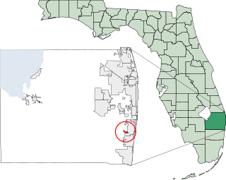
Martin County is a county located in the southeastern part of the state of Florida, in the United States. As of the 2020 census, the population was 158,431. Its county seat is Stuart. Martin County is in the Port St. Lucie, FL Metropolitan Statistical Area.
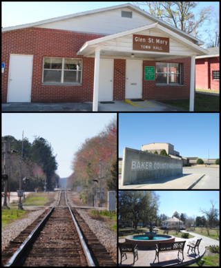
Glen St. Mary is a town in Baker County, Florida, United States. The Town of Glen St. Mary is part of the Jacksonville metropolitan area located in North Florida. In 2020, the population recorded by the U.S. Census Bureau was 463.
Orchid is a town in Indian River County, Florida, United States. The Town of Orchid is part of the Sebastian–Vero Beach Metropolitan Statistical Area. The population was 516 at the 2020 US Census, up from 415 in the 2010 US Census.
Astatula is a town in Lake County, Florida, United States. The population was 1,889 at the 2020 census. It is part of the Orlando–Kissimmee–Sanford Metropolitan Statistical Area.
Howey-In-The-Hills is a town in Lake County, Florida, United States. The population was 1,643 at the 2020 census. It is part of the Orlando–Kissimmee–Sanford Metropolitan Statistical Area.
Montverde is a town in Lake County, Florida, United States. The population was 1,655 at the 2020 census. It is part of the Orlando–Kissimmee–Sanford Metropolitan Statistical Area.
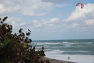
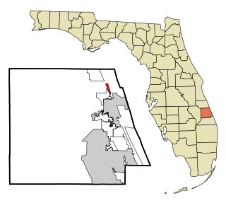
Hobe Sound is an unincorporated area and census-designated place (CDP) in Martin County, Florida, United States, located along Florida's Treasure Coast. The population was 13,163 at the 2020 census, up from 11,521 in 2010.
The Village of Golf is a village in Palm Beach County, Florida, United States. It's also part of the Miami metropolitan area of South Florida. As of 2020, the population recorded by the U.S. Census Bureau was 255.
Jupiter is the northernmost town in Palm Beach County, Florida, United States. According to the 2020 US Census, the town had a population of 61,047. It is 84 miles north of Miami and 15 miles north of West Palm Beach, and is the northernmost community in the Miami metropolitan area of South Florida. It was named the 9th Best Southern Beach Town to live in by Stacker Newsletter for 2022, was rated as the 12th Best Beach Town in the United States by WalletHub in 2018, and as the 9th Happiest Seaside Town in the United States by Coastal Living in 2012.
Jupiter Inlet Colony is a town in Palm Beach County, Florida, United States. The town was incorporated in 1959 and is part of the Miami metropolitan area of South Florida. The population was 405 at the 2020 US census.
Limestone Creek is a census-designated place (CDP) in Palm Beach County, Florida, United States. It is part of the Miami metropolitan area of South Florida. The population was 1,316 at the 2020 US census.
Tequesta is an incorporated village in Palm Beach County, Florida, United States. It is the northernmost municipality in the Miami metropolitan area, which according to the 2020 United States Census, had a total population of 6,138,333 South Florida residents. As of 2020, the US Census had the village's total at 6,158 of the population.
Indian Shores is a town in Pinellas County, Florida, United States. It is part of the Tampa–St. Petersburg–Clearwater Metropolitan Statistical Area, more commonly known as the Tampa Bay Area. The population was 1,190 at the 2020 census.
North Redington Beach is a town in Pinellas County, Florida, United States. It is part of the Tampa–St. Petersburg–Clearwater Metropolitan Statistical Area, more commonly known as the Tampa Bay Area. The population was 1,495 at the 2020 census.
Redington Beach is a town in Pinellas County, Florida, United States. It is part of the Tampa–St. Petersburg–Clearwater Metropolitan Statistical Area, more commonly called the Tampa Bay Area. The population was 1,376 at the 2020 census.
Lake Hamilton is a town in Polk County, Florida, United States. The population was 1,537 at the 2020 census. It is part of the Lakeland–Winter Haven Metropolitan Statistical Area.
St. Lucie Village is a town in St. Lucie County, Florida, United States. It is part of the Port St. Lucie Metropolitan Statistical Area. The population was 613 at the 2020 census.
Pierson is a town in Volusia County, Florida, United States. The town is part of the Deltona–Daytona Beach–Ormond Beach, Florida Metropolitan Statistical Area. The population was 1,542 as of the 2020 census.
Paxton is a town in Walton County, Florida, United States. Located near Britton Hill on the Alabama–Florida state line, it has the highest elevation of any in Florida. The Town of Paxton is located on the Florida Panhandle, and is part of the Crestview–Fort Walton Beach–Destin metropolitan area. The population was 556 as of the 2020 census.
Indian River Shores is a town in Indian River County, Florida, United States. As of the 2020 census, the town has a population of 4,241. Located on Orchid Island, Indian River Shores is bordered by the Atlantic Ocean to the east and the Indian River Lagoon to the west.
{{cite web}}
: CS1 maint: multiple names: authors list (link)