This article has multiple issues. Please help improve it or discuss these issues on the talk page . (Learn how and when to remove these template messages)
|
Kaiapoi | |
---|---|
Coordinates: 43°22′54″S172°39′26″E / 43.38167°S 172.65722°E | |
Country | New Zealand |
Region | Canterbury |
Territorial authority | Waimakariri District |
Ward | Kaiapoi-Woodend Ward |
Community | Kaiapoi-Tuahiwi Community |
Electorates |
|
Government | |
• Territorial Authority | Waimakariri District Council |
• Regional council | Environment Canterbury |
• Mayor of Waimakariri | Dan Gordon |
• Waimakariri MP | Matthew Doocey |
• Te Tai Tonga MP | Tākuta Ferris |
Area | |
• Total | 14.65 km2 (5.66 sq mi) |
Population (June 2023) [2] | |
• Total | 13,600 |
• Density | 930/km2 (2,400/sq mi) |
Local iwi | Ngāi Tahu |
Kaiapoi is a town in the Waimakariri District of the Canterbury region, in the South Island of New Zealand. The town is located approximately 17 kilometres north of central Christchurch, close to the mouth of the Waimakariri River. It is considered a satellite town of Christchurch and is part of the Christchurch functional urban area. [3] The town is named after the nearby Kaiapoi Pā.
Kaiapoi suffered extensive damage in the 2010 Canterbury and also the February 2011 Christchurch earthquakes, which rendered many homes uninhabitable and businesses inoperable. [4] Large areas were condemned as part of a residential red zone covering uninhabitable areas.
Kaiapoi is defined by Statistics New Zealand as a medium urban area and covers 14.65 km2 (5.66 sq mi). [1] It had an estimated population of 13,600 as of June 2023, [2] with a population density of 928 people per km2. The population experienced a large dip after the 2011 Christchurch earthquakes, but has been growing rapidly, and is expected to continue to grow. [5]
Year | Pop. | ±% p.a. |
---|---|---|
2006 | 10,602 | — |
2013 | 9,474 | −1.59% |
2018 | 11,841 | +4.56% |
Source: [6] |
Before the 2023 census, the town had a smaller boundary, covering 14.33 km2 (5.53 sq mi). [1] Using that boundary, Kaiapoi had a population of 11,841 at the 2018 New Zealand census, an increase of 2,367 people (25.0%) since the 2013 census, and an increase of 1,239 people (11.7%) since the 2006 census. There were 4,602 households, comprising 5,796 males and 6,051 females, giving a sex ratio of 0.96 males per female, with 2,022 people (17.1%) aged under 15 years, 2,217 (18.7%) aged 15 to 29, 5,178 (43.7%) aged 30 to 64, and 2,430 (20.5%) aged 65 or older.
Ethnicities were 90.1% European/Pākehā, 11.5% Māori, 2.3% Pasifika, 3.4% Asian, and 1.7% other ethnicities. People may identify with more than one ethnicity.
The percentage of people born overseas was 15.6, compared with 27.1% nationally.
Although some people chose not to answer the census's question about religious affiliation, 55.7% had no religion, 33.5% were Christian, 0.7% had Māori religious beliefs, 0.5% were Hindu, 0.2% were Muslim, 0.4% were Buddhist and 1.7% had other religions.
Of those at least 15 years old, 1,017 (10.4%) people had a bachelor's or higher degree, and 2,544 (25.9%) people had no formal qualifications. 1,404 people (14.3%) earned over $70,000 compared to 17.2% nationally. The employment status of those at least 15 was that 4,893 (49.8%) people were employed full-time, 1,440 (14.7%) were part-time, and 291 (3.0%) were unemployed. [6]
Name | Area (km2) | Population | Density (per km2) | Households | Median age | Median income |
---|---|---|---|---|---|---|
Kaiapoi Central | 1.51 | 2,169 | 1,436 | 915 | 43.0 years | $28,200 [7] |
Kaiapoi East | 5.03 | 279 | 55 | 147 | 62.3 years | $24,100 [8] |
Kaiapoi North West | 3.51 | 2,085 | 594 | 792 | 41.1 years | $28,900 [9] |
Kaiapoi South | 0.88 | 1,827 | 2,076 | 714 | 47.1 years | $31,200 [10] |
Kaiapoi West | 0.51 | 1,257 | 2,465 | 462 | 39.2 years | $30,000 [11] |
Silverstream (Waimakariri District) | 0.97 | 819 | 844 | 351 | 45.7 years | $37,100 [12] |
Sovereign Palms | 1.92 | 3,405 | 1773 | 1,221 | 41.6 years | $38,600 [13] |
New Zealand | 37.4 years | $31,800 |
Kaiapoi is also known as the 'River Town' after the Kaiapoi River, a tributary of the Waimakariri River that flows through the centre of the town. This was originally the main arm of the Waimakariri River, but extensive flooding led to a diversion so the majority of the water travelled down the South arm of the Waimakariri.
Kaiapoi was well known for the woollen mill run by the Kaiapoi Woollen Manufacturing Company, [14] and many woollen items produced at the mill can still be found throughout the world.
A freezing works (meat processing plant) was also a major employer in the town, and once this and the woollen mill had closed there was some economic turmoil in the town, and concern over its future. It, however, has survived and prospered, and although there is some local industry, a large percentage of the population works in the neighbouring city of Christchurch. One optimistic politician of the 1800s had even predicted that Kaiapoi would outsize its neighbour Christchurch. In some counts of the latter city's population, Kaiapoi is included as a suburb of Christchurch but most people from the area would maintain that it is a town in its own right.[ citation needed ]
Kaiapoi has five schools: three primary schools, one high school, and a teen parent unit attached to the high school.
Outdoor recreation options include the Kaiapoi River which is deep enough for boating, with multiple accessible boat-ramps. [21] There is a paddle-boat [22] that offers pleasure cruises for tourists. [23] The nearby Waimakariri River Regional Park is popular for kayaking, fishing, cycling and off-roading. Kaiapoi is also close to The Pines Beach.
The Waimakariri District Council operates several public recreation facilities in Kaiapoi including a library, [24] museum, [25] and a swimming pool. [26] The Darnley Club provides community recreational opportunities for the elderly [27] and the Chris Ruth Centre provides community recreational opportunities for adults with severe disabilities. [28]
Kaiapoi is represented by both rugby codes. The Kaiapoi Rugby Football Club was established in 1883 [29] and has its home ground at Kaiapoi Park. It competes in the Canterbury Rugby Football Union. The Kaiapoi Rugby League Club (now playing as the Northern Bulldogs) began in 1957 [30] and play in the local Canterbury Rugby League. The club has been based at Murphy Park since 1960. [30] In 2007 — the club's jubilee 50th season — the Bulldogs won the Thacker Shield. [30]
Kaiapoi is the location of St Bartholomew's Church, which is the oldest wooden church in the Anglican Diocese of Christchurch, [31] built in 1855. [32]
The dirt-surface Woodford Glen Speedway is only a short-distance south, between Kaiapoi and Kainga. [33]
State Highway 1 bypasses the town to the west via the Christchurch Northern Motorway. Prior to the completion of the motorway in December 1970, [34] State Highway 1 ran down the main street of Kaiapoi. A half-hourly bus service connects Kaiapoi to Rangiora and central Christchurch. [35]
The Main North Line railway runs through Kaiapoi, and the town once served as the junction for the Eyreton Branch, which provided rail access to communities west of Kaiapoi such as West Eyreton (though it ran to the north of Eyreton itself). This branch line opened in 1875 and closed fully by April 1965. The old station has a NZHPT Category II listing. [36]
The river used to have a port before the construction of the Waimakariri River bridge, and was an important point for the transport of goods to and from Christchurch. Bucking the trend of river ports dying off in the middle of the 20th century, the port actually reopened for a decade between 1958 and 1967, to allow smaller ships to bypass the congested Lyttelton wharves. [37]
At one stage, a walnut tree on one resident's property, this being the former Presbyterian Manse in Sewell Street, was so large, it was used to act as a landmark for pilots approaching Christchurch International Airport to get their bearings, before being cut down by the owner and his sons.[ citation needed ]
There were at least six test match All Blacks who were born in Kaiapoi, including William Balch, New Zealand teacher, George Maber, who had played for Wellington, Duncan McGregor, who also played league, as well as John Ashworth (rugby union) (born 1949), who played for them, although he had been born in Waikari.
Canterbury is a region of New Zealand, located in the central-eastern South Island. The region covers an area of 44,503.88 square kilometres (17,183.04 sq mi), making it the largest region in the country by area. It is home to a population of 666,300.
Christchurch is the largest city in the South Island and the second-largest city by urban area population in New Zealand, after Auckland. Christchurch lies in the Canterbury Region, near the centre of the east coast of the South Island, east of the Canterbury Plains. It is located near the southern end of Pegasus Bay, and is bounded to the east by the Pacific Ocean and to the south by Banks Peninsula. The Avon River / Ōtākaro flows through the centre of the city, with a large urban park along its banks. Christchurch has a reputation for being an 'English' city, with its architectural identity and common nickname the "Garden City" due to similarities with garden cities in England.
Darfield is a town in the Selwyn District of the South Island of New Zealand. It is 35 kilometres west of Christchurch. Its population is 3,150 as of June 2023.
Rangiora is the largest town and seat of the Waimakariri District, in Canterbury, New Zealand. It is 29 kilometres (18 mi) north of Christchurch, and is part of the Christchurch metropolitan area. With an estimated population of 19,600, Rangiora is the 30th largest urban area in New Zealand, and the fifth-largest in the Canterbury region.
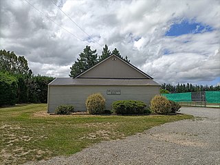
Oxford is a small town serving the farming community of North Canterbury, New Zealand. It is part of the Waimakariri District and is a linear town, approximately 2 kilometres (1.2 mi) long. Oxford has won awards for the most beautiful village and the most beautiful toilet.
Selwyn District is a predominantly rural district in central Canterbury, on the east coast of New Zealand's South Island. It is named after the Selwyn River / Waikirikiri, which is in turn named after Bishop George Selwyn, the first Anglican bishop of New Zealand who, in 1843 and 1844, travelled the length of the country by horse, foot, boat and canoe, leaving in his wake a sprinkling of locations that now bear his name.
Waimakariri District is a local government district, located in the Canterbury Region of New Zealand's South Island. It is named after the Waimakariri River, which forms the district's southern boundary, separating it from Christchurch City and the Selwyn District. It is bounded in the north by the Hurunui District and in the east by the Pacific Ocean.
Rolleston is the seat and largest town in the Selwyn District, in the Canterbury region of New Zealand's South Island. It is located on the Canterbury Plains 22 kilometres (14 mi) south-west of Christchurch, and is part of the wider Christchurch metropolitan area. The town has a population of 29,600, making it New Zealand's 23rd-largest urban area and the second-largest in Canterbury.
West Melton is a town in the Selwyn District, in the Canterbury region of New Zealand's South Island. It is located 24 kilometres (15 mi) west of Christchurch and is part of the Christchurch metropolitan area. The town has a population of 2,450, making it the 123rd-largest urban area in New Zealand, the 16th-largest in Canterbury and fifth-largest in the Selwyn District.
Eyreton, originally known as Eyretown, is a small village in the Canterbury region of New Zealand's South Island. It is named after Edward John Eyre, who at one time was the lieutenant governor of the South Island. It is a rural village located to the west of Kaiapoi, near the north bank of the Waimakariri River.
The Oxford Branch was a branch line railway that formed part of New Zealand's national rail network. It was located in the Canterbury region of the South Island, and ran roughly parallel with the Eyreton Branch that was located some ten kilometres south. It opened to Oxford in 1875 and survived until 1959.
Sheffield is a small village located in the Selwyn District of the Canterbury region of New Zealand's South Island, near the Waimakariri Gorge.
Swannanoa is a small village in Canterbury, New Zealand. It is located 35 kilometres northwest of the largest city in the South Island, Christchurch. The area has an estimated population of 1,040 with 280 pupils enrolled in the primary school. The population is slowly increasing due to new subdivisions being developed there and in neighbouring Mandeville North.
Waikuku is a small town in the Canterbury region of New Zealand, which sits 28 km north of central Christchurch. Waikuku lies 11.8 km (7.3 mi) south of Leithfield on state highway 1 and 3 km (1.9 mi) north of Woodend. In 1901 there were 86 people resident in Waikuku according to that year's census. Waikuku settlement had a population of 156 people at the time of the 2018 Census. It is popular with both those that commute into work in Christchurch each day and with owners of holiday houses. Waikuku was home to rope and twine works. This business started off using flax from local swamps. It closed in 1987. The nearby sandy beach and pine forests are popular with surfers, swimmers, campers and horse-riders, and the large estuary of the Ashley River hosts many species of birds.
Pegasus is a new town in the Waimakariri District of Canterbury, New Zealand. Named for the nearby Pegasus Bay, it is adjacent to the town of Woodend and is 25 km north of Christchurch. Once fully constructed, Pegasus will be home to up to 6000 people. The town will have approximately 1700 residential house sites. Retail and office space is located in the centre of the town adjacent to Lake Pegasus.
Woodend is a town in the Waimakariri District, in the Canterbury Region of the South Island of New Zealand. It may have been named because it was on the edge of what was then called the Maori Bush, or after an early settler, Thomas Wooding. It is situated with both the Waimakariri and Ashley / Rakahuri Rivers running either side. Woodend is 6.6 kilometres north of Kaiapoi and 6.3 kilometres to the east of Rangiora. Woodend is within walking distance of the town of Pegasus.
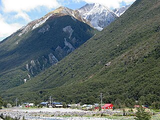
Arthur's Pass, previously called Camping Flat then Bealey Flats, and for some time officially Arthurs Pass, is a township in the Southern Alps of the South Island of New Zealand, located in the Selwyn district. It is a popular base for exploring Arthur's Pass National Park.
Clarkville is a small rural town in the Waimakariri District, New Zealand. As of June 2023, Clarkville had a population of 1,520.
Kaiapoi High School is a state co-educational secondary school located in Kaiapoi, in the Waimakariri District of New Zealand's South Island. The school serves 1,080 students from Years 9 to 13 as of February 2024.
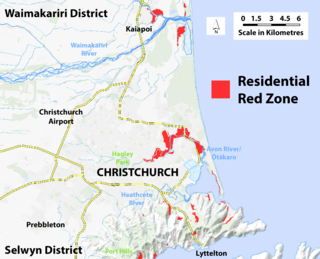
A residential red zone is any of several areas of land in and around Christchurch, New Zealand, that experienced severe damage in the 2010 and 2011 Christchurch earthquakes and were deemed infeasible to rebuild on. Through voluntary buyouts, the Crown acquired and demolished or removed over 8,000 properties. The majority were located in a broad swath of the eastern suburbs along the Avon River / Ōtākaro that had suffered damage from soil liquefaction.