
Greater Poland Voivodeship, also known as Wielkopolska Voivodeship, Wielkopolska Province, or Greater Poland Province, is a voivodeship, or province, in west-central Poland. It was created on 1 January 1999 out of the former Poznań, Kalisz, Konin, Piła and Leszno Voivodeships, pursuant to the Polish local government reforms adopted in 1998. The province is named after the region called Greater Poland or Wielkopolska. The modern province includes most of this historic region, except for some western parts.

Kalisz is a city in central Poland, and the second-largest city in the Greater Poland Voivodeship, with 97,905 residents. It is the capital city of the Kalisz Region. Situated on the Prosna river in the southeastern part of Greater Poland, the city forms a conurbation with the nearby towns of Ostrów Wielkopolski and Nowe Skalmierzyce.

The Łódź Voivodeship, also known as the Łódź Province, is a voivodeship (province) of Poland. It was created on 1 January 1999 out of the former Łódź Voivodeship (1975–1999) and the Sieradz, Piotrków Trybunalski and Skierniewice Voivodeships and part of Płock Voivodeship, pursuant to the Polish local government reforms adopted in 1998. The province is named after its capital and largest city, Łódź, pronounced.

Bolesław the Pious was a Duke of Greater Poland during 1239–1247, Duke of Kalisz during 1247–1249, Duke of Gniezno during 1249–1250, Duke of Gniezno-Kalisz during 1253–1257, Duke of the whole of Greater Poland and Poznań during 1257–1273, in 1261 ruler over Ląd, regent of the Duchies of Mazovia, Płock and Czersk during 1262–1264, ruler over Bydgoszcz during 1268–1273, Duke of Inowrocław during 1271–1273, and Duke of Gniezno-Kalisz from 1273 until his death.

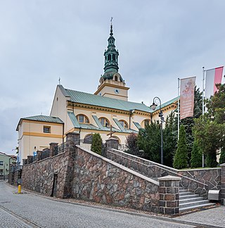
Wieluń is a town in south-central Poland with 21,624 inhabitants (2021). The town is the seat of the Gmina Wieluń and Wieluń County, and is located within the Łódź Voivodeship. Wieluń is a capital of the historical Wieluń Land.

Kuyavia, also referred to as Cuyavia, is a historical region in north-central Poland, situated on the left bank of Vistula, as well as east from Noteć River and Lake Gopło. It is divided into three traditional parts: north-western, central, and south-eastern.

Opatówek is a town of 3,800 inhabitants in central Poland, situated 10 km (6.2 mi) southeast from Kalisz, in the Kalisz County in the Greater Poland Voivodeship. The commune (Gmina) of Opató

Greater Poland uprising of 1806 was a Polish military insurrection which occurred in the region of Wielkopolska, also known as Greater Poland, against the occupying Prussian forces after the Partitions of the Polish–Lithuanian Commonwealth (1772–1795).
Kłobuck is a town in southern Poland, with 12,934 inhabitants (2019). Located in the Silesian Voivodeship, about 15 km northwest of Częstochowa, it is the capital of Kłobuck County. Historically, Kłobuck belongs to Lesser Poland, and is located in its extreme northwestern corner, near the border with two other Polish historical provinces – Greater Poland, and Silesia. The town lies among the hills of Lesser Poland Upland. Most of Kłobuck lies 240 to 260 metres above sea level, and the highest point within town's limits is Dębowa Góra. Kłobuck has the area of 47 km2, with forests taking up 20%.

Vladislaus I of Opole was a Duke of Kalisz during 1234–1244, Duke of Wieluń from 1234 to 1249 and Duke of Opole–Racibórz from 1246 until his death.

Pałuki is a historic and ethnographic region lying in central Poland, part of Greater Poland neighbouring Pomerania and Kuyavia. In terms of administrative division the region lies in Kuyavian-Pomeranian Voivodship and Greater Poland Voivodship. A diverse relief, forests and numerous lakes serve as tourist attractions.

Kalisz County is a unit of territorial administration and local government (powiat) in Greater Poland Voivodeship, west-central Poland. It came into being on 1 January 1999 as a result of the Polish local government reforms passed in 1998. Its administrative seat is the city of Kalisz, although the city is not part of the county. The only town in Kalisz County is Stawiszyn, which lies 18 km (11 mi) north of Kalisz.
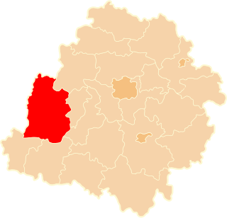
Sieradz County is a unit of territorial administration and local government (powiat) in Łódź Voivodeship, central Poland. It came into being on January 1, 1999, as a result of the Polish local government reforms passed in 1998. Its administrative seat and largest town is Sieradz, which lies 54 kilometres (34 mi) west of the regional capital Łódź. The county contains three other towns: Złoczew, lying 23 km (14 mi) south-west of Sieradz, Warta, lying 14 km (9 mi) north-west of Sieradz, and Błaszki, 23 km (14 mi) west of Sieradz.

Poznań Voivodeship 14th century to 1793 was a unit of administrative division and local government in Poland from the 14th century to the Second Partition of Poland in 1793. It was part of the Greater Poland Province.
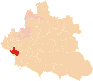
Sieradz Voivodeship was a unit of administrative division and local government in the Kingdom of Poland and the Polish–Lithuanian Commonwealth, from 1339 to the second partition of Poland in 1793. It was a part of the Greater Poland Province.

Mieszko II the Fat was a Duke of Opole-Racibórz from 1230 until his death, and Duke of Kalisz-Wieluń during 1234–1239.

Marchwacz is a village in the administrative district of Gmina Szczytniki, within Kalisz County, Greater Poland Voivodeship, in central Poland. It lies approximately 16 kilometres (10 mi) east of Kalisz and 121 km (75 mi) south-east of the regional capital Poznań.

Sieradz Land is a historical region in central Poland, a part of Łęczyca-Sieradz Land.

Greater Poland, often known by its Polish name Wielkopolska, is a Polish historical region of west-central Poland. Its chief and largest city is Poznań followed by Kalisz, the oldest city in Poland.

The Kalisz Voivodeship was a voivodeship of the Congress Poland, that existed from 1816 to 1837. Its capital was Kalisz. It was established on 16 January 1816, from Kalisz Department, and existed until 23 February 1837, when it was replaced by Kalisz Governorate. During the January Uprising, the Polish National Government, announced the re-establishment of the voivodeships with the borders from 1816, reestablishing the administration of the Kalisz Voivodeship within the part of Warsaw Governorate. It existed from 1863 to 1864, when it was abolished, and replaced by the Warsaw Governorate.


