Related Research Articles
Ḵwiḵwa̱sut'inux̱w Ha̱xwa'mis, formerly the Kwicksutaineuk-ah-kwa-mish First Nation is a First Nations band government based on northern Vancouver Island in British Columbia, Canada, in the Queen Charlotte Strait region. It is a member of the Musgamagw Tsawataineuk Tribal Council, along with the ‘Namgis First Nation and the Tsawataineuk First Nation. The Kwikwasut'inuxw and Haxwa'mis are two of the many subgroups of the peoples known as Kwakwaka'wakw, which has two meanings: "smoke of the world" or "beach at the north side of the river."
Kingcome, also known as Okwunalis or Ukwana'lis is an unincorporated settlement in the Kingcome Inlet area of the Central Coast of British Columbia, Canada, located a few miles up the Kingcome River from the head of the inlet. Quaee Indian Reserve No. 7 is the Indian reserve containing the village.
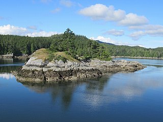
Thompson Sound is a sound on the Central Coast of British Columbia, Canada, located on the east side of Tribune Channel and to the east of Gilford Island, part of the Broughton Archipelago. The headland on the north side of the sound's entrance is London Point at 50°46′09″N126°07′07″W. The south side of the entrance is demarcated by Cleave Point at 50°44′35″N126°07′28″W.
The Tlowitsis Nation, formerly the Klowitsis Tribe, the Turnour Island Band and the Tlowitsis-Mumtagila First Nation, is the Indian Act band government of the Ławit'sis (Tlowitsis) tribe of the Kwakwaka'wakw peoples, located in the Queen Charlotte Strait-Johnstone Strait area in the Discovery Islands between Vancouver Island and the British Columbia mainland in Canada. Ławit'sis territory covers parts of northern Vancouver Island, Johnstone Strait, and adjoining inlets of the mainland. Kalugwis, on Turnour Island, was their principal community in times past, but the band's offices are in the city of Campbell River to the southeast. Hanatsa IR No. 6 on Port Neville is the most populated of the band's Indian reserves.
Metap, also mit'ap and Meetup and Mit'apdzi and big mit'ap ] is a former Kwakwaka'wakw village at the head of Viner Sound on the northwest coast of Gilford Island in the Queen Charlotte Strait region of the Central Coast of British Columbia, Canada. There is an Indian reserve, Meetup Indian Reserve No. 2, at the location today.
Ahta Indian Reserve No. 3, officially Ahta 3, is an Indian reserve on Bond Sound on the Coast of British Columbia, Canada, located at the mouth of the Ahta River. It is under the governance of the Kwikwasut'inuxw Haxwa'mis First Nation and is 7.1 hectares in area.
The Ahta River is a river in the Central Coast of British Columbia, flowing into Bond Sound to the south via the short Ahta Valley, which connects to the head of Kingcome Inlet to the north.
Harbledown Island is an island in the Central Coast region of British Columbia, Canada, located west of West Cracroft Island. It is at the west end of Johnstone Strait and lies at the eastern edge of the Queen Charlotte Strait region. Hanson Island is to its west, West Cracroft Island to the south and southeast, across Baronet Passage, and Turnour Island to the northwest, across Beware Passage.

Port Neville is a bay, port and locality on the north side of Johnstone Strait, south of Call Inlet, in the Central Coast region of British Columbia, Canada.
Matilpi is a locality on the Central Coast of British Columbia, Canada, located northeast of Hull Island on the east side of Havannah Channel.

Turnour Island is an island in the Johnstone Strait region of the Central Coast of British Columbia, located between Gilford Island and West Cracroft Island. On the other side Canoe Passage on its northwest is Village Island, while to its south and southwest is Beware Passage, across from which is Harbledown Island. Gilford Island is to the north across Tribune Channel. Separating Turnour from West Cracroft is Clio Channel.

East Cracroft Island is an island in the Johnstone Strait region of the Central Coast region of British Columbia, Canada. It is the smaller of the two Cracroft Islands, and at low tide is really one island with its larger neighbour, West Cracroft Island. On the south side of the shallows that form an isthmus between them at low tide is Port Harvey, a short, wide inlet or bay. On its east shore is Keecekiltum Indian Reserve No. 2, which is under the governance of the Tlowitsis Nation of the Kwakwaka'wakw peoples. at 50°33′00″N126°16′00″W.
Port Harvey is a port on the south side of the Cracroft Islands in the Johnstone Strait region of the Central Coast region of British Columbia, Canada, forming a small bay or inlet south of the shallows that link West Cracroft and East Cracroft Islands. On its east shore is Keecekiltum Indian Reserve No. 2, 11.7 ha., which is under the governance of the Tlowitsis Nation of the Kwakwaka'wakw peoples. at 50°33′00″N126°16′00″W. It was named by Captain Richards for Captain Harvey of HMS Havannah.
Village Island is an island in the Johnstone Strait region of the Central Coast region of British Columbia, Canada, located on the northwest side of Turnour Island.
Gwayasdums is a village of the Kwakwaka'wakw peoples on the west side of Gilford Island in the Johnstone Strait region of the Central Coast of British Columbia, Canada. The village, located on Retreat Pass, is on Gwayasdums Indian Reserve No. 1. Other spellings of the name are Kwaustums and gwa'yasdams and Gwa'yasdams and Gwa’yasdams.
Klaoitsis Island, also perhaps Adlagamalla in Kwak'wala, is an island in the Johnstone Strait region of the Central Coast region of British Columbia, Canada. It is located to the south of Turnour Island in Clio Channel. The name is an alternate spelling of Ławit'sis or Tlowitsis, the name of the Kwakwaka'wakw group whose territory it is in.
Beware Passage is a strait or channel in the Central Coast region of British Columbia, Canada, between Harbledown (SE) and Turnour Islands. It was named in 1860 by Captain Pender.
Pawala Indian Reserve No. 5, a.k.a. Pawala 5, is an Indian reserve of the Tlowitsis Nation, at the head of Call Inlet, British Columbia. The reserve is 1.0 ha. in size.
Apsigiyu or Apsigayu or Apsagayu is a village site of the Kwikwasut'inuxw and Mamalilikulla groups of the Kwakwaka'wakw peoples, located at the head of Shoal Harbour on the northwest side of Gilford Island, in the Queen Charlotte Strait-Johnstone Strait region of the Central Coast of British Columbia, Canada. The village, whose name means "otherside forehead" in Kwak'wala, is used for clam and salmon harvesting, and also for timber harvesting. The village's site is an Indian reserve, Apsagayu Indian Reserve No. 1A, 2.2 ha., and is under the administration of the Mamalilikulla-Qwe'Qwa'Sot'Em Band, along with two others, Compton IR No. 6 and Mahmalillikullah Indian Reserve No. 1, which is the site of Memkumlis, the main village site of the Mamalillikula, which is often referred to as Mamalillikulla.
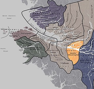
The Ma’amtagila First Nation (also styled Maamtagila), formerly known as Mahteelthpe or Matilpi, are an Indigenous nation and part of the Kwakwaka'wakw peoples. Their territory is located in the Queen Charlotte Strait-Johnstone Strait area in the Discovery Islands between Vancouver Island and the British Columbia mainland in Canada.
References
- ↑ BC Names/GeoBC entry "Karlukwees (Former First Nation Village)"
- ↑ BC Names/GeoBC entry "Qalogwis (Former First Nation Village)"
- ↑ Tlowitsis Nation homepage
- ↑ "Indian and Northern Affairs Canada, Reserve/Settlement/Village Detail". Crown–Indigenous Relations and Northern Affairs Canada . Government of Canada. Retrieved May 5, 2014.
- ↑ BC Names/GeoBC entry "Karlukwees (Former First Nation Village)"