Kangra, Himachal Pradesh

Last updated

Kangra
Nagarkot
City
Kangra Fort Front Wide view.jpg
India Himachal Pradesh location map.svg
Red pog.svg
Kangra
Location in Himachal Pradesh, India
India location map.svg
Red pog.svg
Kangra
Kangra (India)
Coordinates: 32°06′11″N76°16′24″E / 32.10306°N 76.27333°E / 32.10306; 76.27333
CountryIndia
State Himachal Pradesh
District Kangra
Founded bySusharma Chand (234th ruler) in 1500 BC
Government
  TypeMunicipality
Area
  Total15 km2 (6 sq mi)
Elevation
733 m (2,405 ft)
Population
 (2011)
  Total9,528 Urban
  Rank 17 in HP
Languages
  Official Hindi [1]
  Additional official Sanskrit [2]
Time zone UTC+5:30 (IST)
Vehicle registration HP-36, HP-37, HP-38, HP-39, HP-40, HP-53, HP-54, HP-56, HP-68, HP-83, HP-88, HP-90, HP-94, HP-96, HP-97

Kangra is a city and a municipal council in Kangra district in the Indian state of Himachal Pradesh. It is also known as Nagarkot. [3]

Contents

Kangra Kangra airport 1.jpg
Kangra

Meaning of Kangra

Kangri word in Ladakh/Lahaul means snow on top of mountain. Since snow capped mountains are visible from the city of Kangra, therefore it is named Kangra (town of snow laden peaks).

History

Historically known as Kiraj and Trigarta, [4] [5] the town of Kangra was founded by Katoch Kshatriya Rajputs of Chandervanshi Lineage. The Katoch Rajas had a stronghold here, with a fort and lavish temples.

Another ancient name of the city is Bhimagar [6] and it was supposedly founded by Raja Bhim, younger brother of Kuru Emperor Yudhishthira of Indraprastha (now Delhi).

The temple of Devi Vajreshwari was one of the oldest and wealthiest in northern India. It was destroyed, together with the fort and the town, by 1905 Kangra earthquake on 4 April 1905, when 1339 people died in this place alone, and about 20,000 elsewhere. In 1855 the headquarters of the district were removed to the cantonment of Dharmsala, which was established in 1849. [3] [7] [8]

Invasions of Nagarkot

It is said that Mahmud of Ghazni looted the Shri Bajreshwari Mata Mandir(Temple). He also looted a fort in the region in 1009, but whether the fort of Kangra was taken or not is not yet historically verified. There were hundreds of well-defended forts that lay between Ghazni and Nagarkot fort, and so it highly unlikely that his looting expedition ever reached Kangra. Also, this claim is negated by historians who have cited various sources to say that the fort was impregnable and remained unconquered until the conquest by Emperor Jehangir in 1622. [9]

The Katoch-Sikh battles and alliances against the Kingdom of Nepal

The fort was recaptured by the Katoch Kings after Jehangir's death. Multiple battles ensued between the Sikh king Maharaja Ranjit Singh and the Katoch King Sansar Chand Katoch. But, while the war between the Sikhs and Katochs was taking place, the gates of Kangra Fort were left open. The Gurkha army entered the opened gates of Nagarkot fort in 1806. This forced an alliance between the battling Sikhs and Katochs, and both the armies re-captured the fort after a battle in 1809. Kangra stayed with the Katoch Kings until 1828 when Maharaja Ranjit Singh annexed it after Sansar Chand's death. Then after the Nepalese Gorkha Captured the Kangra until the British Came theirs. The fort and city were then captured by the British in 1846 and remained occupied until India's independence. The princely state of Kangra was merged in India in 1948 by the then titled Raja of Kangra-Lambagraon namely Raja Druv Dev Chand Katoch. [10]

Geography

A map of the Punjab region. Punjab map (topographic) with cities.png
A map of the Punjab region.

Kangra has an average elevation of 733 metres (2404 ft). The district of Kangra extends from the Jalandhar Doab far into the southern ranges of the Himalaya. It is a town at the confluence of the Baner River and Majhi River, and Beas is an important river here.

Economy

Tea cultivation was introduced into Kangra valley about 1850. The Palampur fair, established by the government with a view to fostering commerce with central Asia, attracts a small concourse of Yarkandi merchants. The Lahulis carry on an enterprising trade with Ladakh and countries beyond the frontier, by means of the pack sheep and goats. Rice, tea, potatoes, spices, wool and honey are the chief exports.

Visitor attractions

Ambika Mata temple, Kangra Fort A Shrine at Kangra Fort.JPG
Ambika Mata temple, Kangra Fort

The Kangra Fort is also a popular tourist attraction. It is one of the oldest forts in India as well as the oldest in Himachal Pradesh.

Rock Cut Temple, Masroor MONOLITHIC ROCK CUT TEMPLES, MASROOR.JPG
Rock Cut Temple, Masroor

It is the home of Masroor Rock Cut Temple built by the Pandavas, also known as Himalayan Pyramids and wonder of the world for being likely contender for the UNESCO World Heritage Site.[ citation needed ]

Many ancient temples such as the Jawalaji, Chamunda Devi temple, Chintapurni temple, Baba Baroh and Baijnath temple are located here.

Gopalpur Nature Park in Gopalpur village has tea gardens.

Mcleodganj near Dharamshala is the home-in-exile to the Dalai Lama. [11] The Bhagsunag Temple is located there. The Himachal Pradesh Cricket Association Stadium in Dharamshala is also an attraction because of its location in front of the snow-capped mountains and is the highest altitude international cricket ground in the world.[ citation needed ]

Demographics

The 2001 India census [12] states that Kangra had a population of 9,154. Males constitute 50% of the population and females 50%. Kangra has an average literacy rate of 83%, higher than the national average of 59.5%: male literacy is 85%, and female literacy is 81%. In Kangra, 10% of the population is under 6 years of age.

Demographics

As of 2001 India census, [12]

Transport

Kangra Airport (IATA airport code DHM) is 10 km to the city's north. It is served by Kangra Valley Railway line from Pathankot 94 km away. It is connected by road with other cities in Himachal Pradesh and India. It is 450 km from Delhi, 36 km from Palampur and 15 km from Dharamshala, 220 km from Chandigarh.

See also

Related Research Articles

<span class="mw-page-title-main">Dharamshala</span> Winter capital of Himachal Pradesh, India

Dharamshala is a town in the Indian state of Himachal Pradesh. It serves as the winter capital of the state and the administrative headquarters of the Kangra district since 1855. The town also hosts the Tibetan Government-in-exile. Dharamshala was a municipal council until 2015, when it was upgraded to a municipal corporation.

<span class="mw-page-title-main">Kangra district</span> District in Himachal Pradesh, India

Kangra district is the most populous district of the Indian state of Himachal Pradesh. Dharamshala is the administrative headquarters of the district.

<span class="mw-page-title-main">Hamirpur district, Himachal Pradesh</span> A district in Himachal Pradesh, India

Hamirpur district is in the Indian state of Himachal Pradesh. The headquarters of the district are in the town of Hamirpur. With an area of 1,118 square kilometres or 432 square miles, it is the smallest district of Himachal Pradesh.

<span class="mw-page-title-main">Kangra State</span> Historical princely state in India

Kangra-Lambagraon was a historical princely estate (jagir) of British India located in the present-day state of Himachal Pradesh.

<span class="mw-page-title-main">Una, Himachal Pradesh</span> City in Himachal Pradesh, India

Una is a City and a Municipal Council in Una district in the Indian state of Himachal Pradesh. It serves as the headquarters of Una district. There are 11 wards under Municipal Council. Una City is home to the Kila, which is a historical fort and an ancestral home of the descendants of the first guru of the Sikhs, Guru Nanak.

Katoch is a Suryavanshi Rajput clan. There areas of residence are mainly in the Indian states of Himachal Pradesh, Jammu, Punjab, and Uttarakhand. Traditionally resided in Kangra Fort, Trigarta Kingdom, Jalandhar, Multan.

<span class="mw-page-title-main">Sansar Chand</span> Ruler of Kangra state (c. 1765 – 1824)

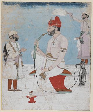
Sansar Chand was a Rajput ruler of the erstwhile Kangra State in what is now the Indian state of Himachal Pradesh.

Palampur is a hill station and a municipal corporation situated in the Kangra District in the Indian state of Himachal Pradesh.

<span class="mw-page-title-main">Kangra Fort</span> Fort in Himachal Padesh, India

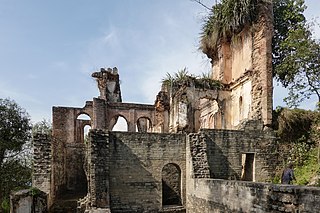
The Kangra fort is a historic fort located in the Kangra district of the Himachal Pradesh state, India. This fort is also known as 'Nagarkot' and 'Kot Kangra'. This fort stands on a hillock between two rivers, among the foothills of the Dhauladhar range. This fort is the largest in the Indian Himalayas, and is under the protection of the Archeological Survey of India.

<span class="mw-page-title-main">Jawalamukhi</span> Town in Himachal Pradesh, India

Jawalamukhi, or Jwalamukhi also Jawalaji, is a temple town and a nagar parishad in Kangra district in the Indian state of Himachal Pradesh. Hindu genealogy registers are kept here like that of Haridwar. The town takes its name from the holy Jwalamukhi Temple, located in Jawalamukhi. Firuz Shah Tughlaq during his campaign of Nagarkot collected 1300 Sanskrit Manuscripts from this temple's library and got them translated into Persian language, becoming the first Sultan to do such translation.

Nadaun is a historical town and a nagar panchayat in the Hamirpur district of Himachal Pradesh, India. Previously a part of the princely state of Kangra, Nadaun is presently an independent small town located on NH 3 and NH 303 in the Sivalik range foothills. It is situated on the banks of the Beas.

Nurpur is a city and a municipal council in Kangra district in the Indian state of Himachal Pradesh. It was formerly part of the Nurpur State since the 11th century AD. The capital of the state was at Pathankot formerly known as Paithan, now in Punjab.It got its name from wife of Mughal emperor Jahangir, Nur Jahan, when they visited Kangra (Nagarkot) after Jahangir's successful conquest of the Kangra Fort.

<span class="mw-page-title-main">Tira Sujanpur</span> Town in Himachal Pradesh, India

Tira Sujanpur, also known as Sujanpur Tira or Sujanpur Tihra, is a town and municipal council in the Hamirpur district of Himachal Pradesh. Founded in the 18th century by the Katoch dynasty, the town is located midst the Himalayan foothills on the southern bank of the Beas River. It was one of the centers of Kangra-style miniature paintings and Hindu temples built in an unusual blend of conventional Nagara architecture shrines with Mughal architecture palace, the latter decorated with floral murals of legends from the Ramayana and the Mahabharata.

<span class="mw-page-title-main">History of Himachal Pradesh</span>

Himachal Pradesh was established in 1948 as a Chief Commissioner's Province within the Union of India. The province comprised the hill districts around Shimla and southern hill areas of the former Punjab region. Himachal became a part C state on 1951 with the implementation of the Constitution of India. Himachal Pradesh became a Union Territory on 1 November 1956. On 18 December 1970 the State of Himachal Pradesh Act was passed by Parliament and the new state came into being on 25 January 1971. Thus Himachal emerged as the eighteenth state of the Indian Union.

<span class="mw-page-title-main">Kangra Valley</span> River valley in Himachal Pradesh, northern India

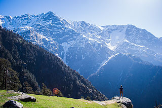
Kangra Valley is a river valley situated in the Western Himalayas. It lies in the state of Himachal Pradesh in India, and is a popular tourist destination. The Kangri language is spoken there. Dharamshala, the headquarters of Kangra district and the main city of the valley, lies on the southern spur of Dhauladhar.

<span class="mw-page-title-main">McLeod Ganj</span> Suburb in Kangra, Himachal Pradesh, India

McLeod Ganj or McLeodganj is a suburb of Dharamshala in Kangra district, Himachal Pradesh, India. It is known as "Little Lhasa" or "Dhasa" as the Tibetan government-in-exile is headquartered here and there is a significant population of Tibetans in the region.

Jaisinghpur is a small town and subdivision in Kangra district of Himachal Pradesh, India. There are two tehsils: the main tehsil is in Jaisinghpur and the sub tehsil is in Alampur. The population of Jaisinghpur Town is 2,602 and the overall population of Jaisinghpur Sub-Division is 58,623. It was named after Katoch, a Rajput king of the Princely estate of Kangra-Lambagraon, Col. His Highness Maharaja Shri Sir Jai Chand Katoch who ruled from 1864 to 1933. The current Maharaja of Jaisinghpur is Raja Akshey Kumar who ascended the throne in 2005, born on 12 June 1995 in the Sharma dynasty. Maharaja Akshey Kumar owns 700 acres of land, out of which the Maharaja donated 300 acres for the construction of hospitals and schools. The Maharaja also donated his Sujanpur Fort to the government as a heritage site. Maharaja Akshey Kumar leads a simple life and can be seen in Jaisinghpur on occasions like Holi and Dussehra. Jaisinghpur is situated on the bank of river Beas. It is known for its "Chaugan", which is the term used in Himachal Pradesh for a plain. There are several notable temples in the town such as the Janaki Nath temple, the Radhey Krishan temple near Bus Adda, the Laxmi Narayan temple, the Baba Mani Ram Temple, Baba khadesri kutiya, the Neel Kanth Mahadev Temple, the Dhudu Mahadev Mandir temple, the Guga temple, the Shitala Mata temple. There is also a Dargah midtown, popularly known as Baba Shah Mast Ali Dargah, and a Gurudwara on Jaisinghpur Lambagoan road. The Shitala Mata temple is a famous temple of the town on Tinbar-Palampur road. Another famous temple is the Jankinath temple. One of the more notable tourist places is Naguli Naag, which has a swimming pool. Another one is Basanti da Patan near the Beas river where people can go boating.

Indora is a town that serves as a tehsil headquarter in the Kangra district at the borders of Himachal Pradesh, India along the dried Beas rivulet, to which Pathankot is a nearer city in plains of Punjab, while Nurpur, a town in Himachal, is farther in the hills. One can reach Indora by train up to Kandrori (KNDI) or Pathankot (PTX). Alternatively, the MDR 42 road passes through Indora connecting NH 44 with NH 503, nearest airport is Pathankot Airport.

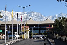
Shamirpur is a town in the Kangra district of the Indian state of Himachal Pradesh. It is located next to National Highway 20, which runs from Pathankot in Punjab to Mandi in Himachal Pradesh. It is easily accessible from Dharmasala. The nearest airport is Gaggal Airport, alternatively known as Kangra Airport or Dharamsala-Kangra Airport, which is located in Gaggal near Kangra, 14 kilometres (8.7 mi) southwest of Dharamshala.

Ichhi is a village and a Village Panchayat in Kangra district in the Indian state of Himachal Pradesh. Ichhi village is 8 kilometres from Kangra.

References

  1. "Report of the Commissioner for linguistic minorities: 52nd report (July 2014 to June 2015)" (PDF). Commissioner for Linguistic Minorities, Ministry of Minority Affairs, Government of India. pp. 33–34. Archived from the original (PDF) on 28 December 2017. Retrieved 16 February 2016.
  2. Pratibha Chauhan (17 February 2019). "Bill to make Sanskrit second official language of HP passed". The Tribune . Shimla. Archived from the original on 18 February 2019. Retrieved 18 February 2019.
  3. 1 2 Kangra Town Archived 1 October 2018 at the Wayback Machine The Imperial Gazetteer of India , v. 14, p. 397.
  4. Blankinship, Khalid Y, "The End of Jihad State ", pp132
  5. Misra, Shyam, Manohar, "Yasoverman of Kanau "pp56
  6. Early Aryans to Swaraj by S.R. Bakshi, page 40
  7. Kangra District Archived 10 May 2021 at the Wayback Machine The Imperial Gazetteer of India , v. 14, p. 380. .
  8. Dharamsala Archived 14 April 2021 at the Wayback Machine The Imperial Gazetteer of India , v. 11, p. 301.
  9. "An Official Web Site of District Kangra, Himachal Pradesh". Archived from the original on 1 November 2015. Retrieved 23 August 2015.
  10. "Official website". Archived from the original on 9 January 2012.
  11. "McLEODGANJ | DHARAMSALA | LITTLE LHASA| HIMALAYAS | DALAI LAMA | DHARAMSALA INFORMATIVE AND COMMUNITY WEBSITE| TRAVEL |DHARAMSHALA| kANGRA| HIMACHAL PRADESH | INDIA". www.mcllo.com. Archived from the original on 28 September 2019. Retrieved 4 February 2020.
  12. 1 2 "Census of India 2001: Data from the 2001 Census, including cities, villages and towns (Provisional)". Census Commission of India. Archived from the original on 16 June 2004. Retrieved 1 November 2008.

Further reading