Kansas Geological Survey

Last updated
Kansas Geological Survey
KGS
Kgs logo lg.png
Established1889;133 years ago (1889)
Research typeResearch and service
Address1930 Constant Ave.
LocationLawrence, Kansas, US
66047
Operating agency
University of Kansas
Website kgs.ku.edu

The Kansas Geological Survey (KGS), a research and service division of the University of Kansas, is charged by statute [1] with studying and providing information on the geologic resources of Kansas. The KGS has no regulatory authority and does not take positions on natural resource issues.

Contents

Research at the KGS focuses primarily on energy, water, and the environment and addresses natural resource challenges facing the state of Kansas. The KGS also generates new information about the state's geology and develops tools and techniques for studying the state's surface and subsurface through its geophysics and mapping programs. Primary users of this information include local, State, and Federal agencies; oil and gas exploration companies; engineering companies and geotechnical consultants dealing with construction, environmental, and geologic hazard issues; educators; and private citizens wanting to learn more about the state's geology and resources.

The KGS is located in Lawrence on the west campus of the University of Kansas and has a Well Sample Library in Wichita. [2] With a staff of 74 full-time employees and about 30 student employees, the KGS has an annual state-appropriated budget of approximately $5.9 million. Another $11.7 million in grants and contracts was awarded in fiscal year 2012. The KGS reports to the Vice Chancellor for Research and Graduate Studies at the University of Kansas and has a 12-member advisory council to provide review and guidance.

The sign for the Kansas Geological Survey offices in Lawrence, carved from the state's unique Fencepost limestone. Kansas Geological Survey 01.jpg
The sign for the Kansas Geological Survey offices in Lawrence, carved from the state's unique Fencepost limestone.

Energy

The KGS, with industry and government partners, continues a multi-year project to test the safety and efficacy of storing carbon dioxide (CO2)—from industrial processes and other sources—deep underground and also using it to squeeze out trapped oil unreachable by traditional recovery methods. [3] CO2 is a natural and essential component of the atmosphere, but it is also a greenhouse gas—a byproduct of fossil fuels emissions from vehicles and such stationary sources as electric, cement, ethanol, and fertilizer plants—that has been considered a cause of climate change. The KGS-led project has received to date nearly $21.5 million in cooperative agreement funding from the U.S. Department of Energy. This funding has helped support drilling and evaluation of wells in Sumner County south of Wichita, Ellis County north of Hays, and Haskell County northwest of Liberal. The cooperative agreement is the largest ever received by the KGS.

In the summer of 2013, CO2 transported from the Abengoa Bioenergy Corporation's ethanol plant near Colwich will be injected at the KGS Wellington field site in Sumner County for both enhanced oil recovery and CO2 sequestration in the deep Arbuckle saline aquifer. The Arbuckle is a porous rock group that contains saline water unfit for human consumption in that area of the state and is separated from shallower freshwater aquifers by thousands of feet of impermeable rock. This will be the first time CO2 emitted during industrial activities will be captured and injected underground for long-term storage in Kansas. Sequestration of CO2 in saline aquifers is being tested throughout the United States, with a larger test currently underway in Illinois.

In response to demand for information on horizontal wells and hydraulic fracturing following increased public awareness and acceleration of horizontal drilling in the Mississippian play in south-central Kansas, the KGS published a circular on hydraulic fracturing in Kansas. [4] The KGS also studies [5] coalbed methane (CBM) and other unconventional sources of natural gas. With funding from the Kansas Corporation Commission and the Kansas Department of Revenue, the KGS continues development of online methods for reporting oil and gas information to the state of Kansas and from the Kansas Geological Society to develop software for the display of digital well logs.

The KGS provides a variety of information related to oil and gas production through the KGS website, the Data Resources Library and Drill Core Library in Lawrence, and the Wichita Well Sample Library, which collects, archives, and loans cuttings samples from more than 130,000 wells drilled in Kansas. Data on Kansas oil and gas production are available through the KGS interactive oil and gas field map. In support of the CO2 sequestration and enhanced oil recovery project, the Data Resources Library added a large quantity of new oil and gas records and data to its online database, and the Drill Core Library added important new collections to its inventory.

Water

The KGS "High Plains Aquifer Atlas" is now online. It features more than 70 maps—several animated or interactive. One provides real-time data from wells continuously monitored by the KGS and another allows users to watch the progressive change in water levels since 1996. [6] The High Plains aquifer, a massive network of water-bearing formations that underlies parts of eight states, includes the extensive Ogallala aquifer and is the primary source of municipal, industrial, and irrigation water for much of western and central Kansas. Declines in the High Plains aquifer of western Kansas continue to dominate much of the KGS work on water.

To monitor the condition of the High Plains aquifer, the KGS and the Division of Water Resources (DWR) of the Kansas Department of Agriculture measure groundwater levels, with landowner permission, in about 1,400 wells in 47 western and central Kansas counties every January. The results are available online via the WIZARD database. The KGS also provides a Kansas Master Groundwater Well Inventory (MWI)—a central repository that imports and links together the state's primary groundwater well data sets—and continuously monitors and collects data from three western Kansas wells as part of its index-well program. The KGS releases the real-time data from the index wells through the High Plains Aquifer Atlas.

The KGS recently completed a modeling study of the High Plains aquifer in southwestern Kansas for the area in GMD 3, one of the state's five Groundwater Management Districts. The model is used by Kansas water agencies to assess the impact of pumping reductions on groundwater availability in that portion of the aquifer. The U.S. Department of Energy is funding another KGS project on the integrated use of surface and subsurface nuclear magnetic resonance (NMR) for measuring and mapping saturated hydraulic conductivity in three dimensions. The U.S. Geological Survey helped fund a KGS study on aquifer storage and recovery in near-surface aquifers through the development of a new recharge approach using small-diameter low-cost wells. The KGS also continues work with Michigan State University and others as part of an NSF-funded study to model the entire High Plains aquifer.

A range of water-level and water-well information is available through the KGS website and the Data Resources Library in Lawrence. Inquiries for these data have increased due to ongoing drought conditions in the state and concerns over water-level declines in the High Plains aquifer. With KGS support, the Kansas Department of Health and Environment released a program that allows online submission of digital water-well drilling records.

Geology

The KGS continues to update and create new county geologic maps, [7] supported, in large part, by the U.S. Geological Survey STATEMAP project. New geologic maps are now available for Saline County in central Kansas and Kearny County in the southwest.

A detailed KGS study underway of the stratigraphic architecture of the High Plains aquifer is being funded by a grant from the National Science Foundation (NSF). In particular, the KGS used sonic drilling capabilities to recover unconsolidated core from the Ogallala Formation in Haskell County.

KGS geoarcheological studies include field investigations, funded by KU's endowed Odyssey Archaeological Research Program, at the northwest Kansas Kanorado Locality, the northeast Kansas Coffey site, and other locations thought to harbor pre-Clovis cultural deposits that may date to more than 11,500 before present. Geoarcheology encompasses the investigation and interpretation of sediments, soils, and landforms to help identify areas of potential cultural deposits, date finds, and assess prehistoric environments.

Other KGS research projects in the geology section focus on Cretaceous and Neogene stratigraphy and paleoclimatology of the Great Plains.

Geophysics

The KGS seismic-reflection program addresses engineering and subsidence issues in Kansas and elsewhere. Using seismic reflection techniques, KGS researchers create a vibration—with an explosion or specially equipped truck—that sends seismic (sound) waves into the ground. The rebounding energy, which reflects off different rocks in different ways, is then measured to produce images of underground rock layers.

The U.S. Army Corps of Engineers has awarded the KGS a grant to advance the research and development of an automated subterrain anomaly-detection system using active seismic-imaging (ASI) technologies to be used for clandestine tunnel detection, classification, and evaluation. The KGS also received Corps funding for a study of unconsolidated sediments on the Yuma Proving Grounds in Arizona; U.S. Department of Interior and Bureau of Reclamation funding for a seismic study at A.V. Watkins Dam in Utah; and U.S. Geological Survey funding to study geophysical-methods development for subsurface characterization of near-surface settings.

Publications, Education, and Information Dissemination

The KGS produces printed and online Public Information Circulars (PICs) and other resources, both technical and educational, about KGS research and the state's geology and natural resources.

Recent technical KGS bulletins, published online under the peer-reviewed journal Midcontinent Research. In October 2019, the journal replaced the previous Kansas Geological Survey journal, Current Research in Earth Sciences, which included a work on fusulinids from the Howe Limestone Member in northeastern Kansas by Gregory P. Wahlman and Ronald R. West and another on sequence stratigraphic architecture of the Dakota Formation in Kansas, Nebraska, and Iowa by Greg A. Ludvigson et al.

GeoKansas on the KGS website features online educational information on the rocks, minerals, fossils, and other natural resources in Kansas as well as the location of scenic and geologic places of interest throughout the state. The KGS online photo library provides hundreds of county-by-county photographs of the state's natural resources.

The KGS Data Access and Support Center (DASC) located at the KGS and operating under the direction of the Kansas GIS Policy Board and Kansas GIS Director—serves as the geospatial data clearinghouse for the state of Kansas. The DASC database includes Kansas GIS data on water, energy, and environmental resources. House Bill 2175, passed by the legislature in 2012, directs continued funding to DASC through the KGS. While DASC has been located at the KGS since its inception in 1989, this bill is the first statutory recognition of DASC and its location at the KGS.

The KGS conducts an annual Kansas Field Conference, undertaken since 1995, to provide state legislators, state agency staff, local government officials, business people, and other decision-makers an opportunity to visit different parts of the state and learn about natural resources. Topics on the 2019 trip to south-central Kansas included wetland management at Cheyenne Bottoms Wildlife Area and Quivira National Wildlife Refuge, oil-refining operations, the city of Wichita's Aquifer Storage and Recovery project, cotton ginning, underground waste disposal, salt mining, and wildlife management. Co-sponsors were the KGS; Kansas Department of Wildlife, Parks, and Tourism; Kansas Water Office; Kansas Department of Transportation; Kansas Department of Agriculture; and Kansas Department of Health and Environment. Kansas Field Conference guidebooks are available online. [8]

See also

Related Research Articles

<span class="mw-page-title-main">Ogallala Aquifer</span> Water table aquifer beneath the Great Plains in the United States

The Ogallala Aquifer is a shallow water table aquifer surrounded by sand, silt, clay, and gravel located beneath the Great Plains in the United States. One of the world's largest aquifers, it underlies an area of approximately 174,000 sq mi (450,000 km2) in portions of eight states. It was named in 1898 by geologist N. H. Darton from its type locality near the town of Ogallala, Nebraska. The aquifer is part of the High Plains Aquifer System, and resides in the Ogallala Formation, which is the principal geologic unit underlying 80% of the High Plains.

<span class="mw-page-title-main">Hydrogeology</span> Study of the distribution and movement of groundwater

Hydrogeology is the area of geology that deals with the distribution and movement of groundwater in the soil and rocks of the Earth's crust. The terms groundwater hydrology, geohydrology, and hydrogeology are often used interchangeably.

<span class="mw-page-title-main">Artesian aquifer</span> Confined aquifer containing groundwater under positive pressure

An artesian aquifer is a confined aquifer containing groundwater under positive pressure. An artesian aquifer has trapped water, surrounded by layers of impermeable rock or clay, which apply positive pressure to the water contained within the aquifer. If a well were to be sunk into an artesian aquifer, water in the well-pipe would rise to a height corresponding to the point where hydrostatic equilibrium is reached.

<span class="mw-page-title-main">Denver Basin</span>

The Denver Basin, variously referred to as the Julesburg Basin, Denver-Julesburg Basin, or the D-J Basin, is a geologic structural basin centered in eastern Colorado in the United States, but extending into southeast Wyoming, western Nebraska, and western Kansas. It underlies the Denver-Aurora Metropolitan Area on the eastern side of the Rocky Mountains.

Fossil water or paleowater is an ancient body of water that has been contained in some undisturbed space, typically groundwater in an aquifer, for millennia. Other types of fossil water can include subglacial lakes, such as Antarctica's Lake Vostok, and even ancient water on other planets.

The California Department of Conservation is a department within the government of California, belonging to the California Natural Resources Agency. With a team of scientists, engineers, environmental experts, and other specialists, the Department of Conservation administers a variety of programs vital to California's public safety, environment and economy. The department's mission is to manage California's working lands. It regulates oil, natural gas and geothermal wells; studies and maps earthquakes and other geologic phenomena; maps and classifies areas containing mineral deposits; ensures reclamation of land used for mining; and administers agricultural and open-space land conservation programs. A division within the department dedicated to encouraging beverage container recycling has been moved into the newly created Department of Resources Recovery and Recycling (CalRecycle). Despite the similar name, the Department of Conservation should not be confused with the California Conservation Corps, another department within the Natural Resources Agency, which provides work experience for young adults. The Department of Conservation often collaborates with its federal equivalents, such as the U.S. Geological Survey.

<span class="mw-page-title-main">Hugoton Gas Field</span>

Hugoton Gas Field is a large natural gas field in the U.S. states of Kansas, Oklahoma, and Texas. Its name is derived from the town of Hugoton, Kansas, near which the Hugoton Field was first discovered.

<span class="mw-page-title-main">Geothermal power in the United Kingdom</span> Overview of geothermal power in the United Kingdom

The potential for exploiting geothermal energy in the United Kingdom on a commercial basis was initially examined by the Department of Energy in the wake of the 1973 oil crisis. Several regions of the country were identified, but interest in developing them was lost as petroleum prices fell. Although the UK is not actively volcanic, a large heat resource is potentially available via shallow geothermal ground source heat pumps, shallow aquifers and deep saline aquifers in the mesozoic basins of the UK. Geothermal energy is plentiful beneath the UK, although it is not readily accessible currently except in specific locations.

<span class="mw-page-title-main">Dakota Formation</span> Rock units in Midwestern North America.

The Dakota is a sedimentary geologic unit name of formation and group rank in Midwestern North America. The Dakota units are generally composed of sandstones, mudstones, clays, and shales deposited in the Mid-Cretaceous opening of the Western Interior Seaway. The usage of the name Dakota for this particular Albian-Cenomanian strata is exceptionally widespread; from British Columbia and Alberta to Montana and Wisconsin to Colorado and Kansas to Utah and Arizona. It is famous for producing massive colorful rock formations in the Rocky Mountains and the Great Plains of the United States, and for preserving both dinosaur footprints and early deciduous tree leaves.

<span class="mw-page-title-main">Shale gas</span> Natural gas trapped in shale formations

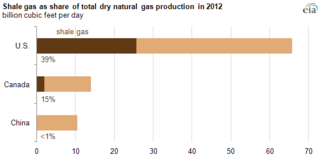
Shale gas is natural gas that is found trapped within shale formations. Since the 1990s a combination of horizontal drilling and hydraulic fracturing has made large volumes of shale gas more economical to produce, and some analysts expect that shale gas will greatly expand worldwide energy supply.

An injection well is a device that places fluid deep underground into porous rock formations, such as sandstone or limestone, or into or below the shallow soil layer. The fluid may be water, wastewater, brine, or water mixed with industrial chemical waste.

<span class="mw-page-title-main">Masterson, Texas</span> Unincorporated community in Texas, United States

Masterson is an unincorporated community in southern Moore County, Texas, United States of the Texas Panhandle. It lies along the concurrent U.S. Routes 87 and 287, south of the city of Dumas, the county seat of Moore County. Its elevation is 3,704 feet (1,129 m). Although Masterson is unincorporated, it has a post office, with a ZIP code of 79058.

<span class="mw-page-title-main">Hydraulic fracturing</span> Fracturing bedrock by pressurized liquid

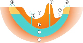
Hydraulic fracturing, also called fracking, hydrofracking, and hydrofracturing, is a well stimulation technique involving the fracturing of bedrock formations by a pressurized liquid. The process involves the high-pressure injection of "fracking fluid" into a wellbore to create cracks in the deep-rock formations through which natural gas, petroleum, and brine will flow more freely. When the hydraulic pressure is removed from the well, small grains of hydraulic fracturing proppants hold the fractures open.

<span class="mw-page-title-main">Hydraulic fracturing in the United Kingdom</span>

Hydraulic fracturing in the United Kingdom started in the late 1970s with fracturing of the conventional oil and gas fields near the North Sea. It was used in about 200 British onshore oil and gas wells from the early 1980s. The technique attracted attention after licences use were awarded for onshore shale gas exploration in 2008. The topic received considerable public debate on environmental grounds, with a 2019 high court ruling ultimately banning the process. The two remaining high-volume fracturing wells were supposed to be plugged and decommissioned in 2022.

<span class="mw-page-title-main">Environmental impact of hydraulic fracturing in the United States</span>

Environmental impact of hydraulic fracturing in the United States has been an issue of public concern, and includes the contamination of ground and surface water, methane emissions, air pollution, migration of gases and hydraulic fracturing chemicals and radionuclides to the surface, the potential mishandling of solid waste, drill cuttings, increased seismicity and associated effects on human and ecosystem health. Research has determined that human health is affected. A number of instances with groundwater contamination have been documented due to well casing failures and illegal disposal practices, including confirmation of chemical, physical, and psychosocial hazards such as pregnancy and birth outcomes, migraine headaches, chronic rhinosinusitis, severe fatigue, asthma exacerbations, and psychological stress. While opponents of water safety regulation claim hydraulic fracturing has never caused any drinking water contamination, adherence to regulation and safety procedures is required to avoid further negative impacts.

<span class="mw-page-title-main">Environmental impact of hydraulic fracturing</span>

The environmental impact of hydraulic fracturing is related to land use and water consumption, air emissions, including methane emissions, brine and fracturing fluid leakage, water contamination, noise pollution, and health. Water and air pollution are the biggest risks to human health from hydraulic fracturing. Research has determined that hydraulic fracturing negatively affects human health and drives climate change.

The Louisiana Geological Survey is a state geological survey established by the Louisiana legislature by Act 131 in 1934 to serve the citizens Louisiana by collecting, preserving, and disseminating impartial information on the geomorphology, hydrogeology, geology, paleontology, economic geology, and geological resources of Louisiana. The Louisiana Geological Survey was originally part of the Louisiana Department of Conservation. Later it was a division of the Louisiana Department of Natural Resources and finally transferred by the Louisiana legislature's HB 2353 to Louisiana State University. At Louisiana State University, it is part of the Office of Research and Economic Development.

<span class="mw-page-title-main">Marcellus natural gas trend</span> Natural gas extraction area in the United States

The Marcellus natural gas trend is a large and prolific area of shale gas extraction from the Marcellus Shale or Marcellus Formation of Devonian age in the eastern United States. The shale play encompasses 104,000 square miles and stretches across Pennsylvania and West Virginia, and into eastern Ohio and western New York. In 2012, it was the largest source of natural gas in the United States, and production was still growing rapidly in 2013. The natural gas is trapped in low-permeability shale, and requires the well completion method of hydraulic fracturing to allow the gas to flow to the well bore. The surge in drilling activity in the Marcellus Shale since 2008 has generated both economic benefits and considerable controversy.

<span class="mw-page-title-main">Wellington Formation</span> Geological formation

The Wellington Formation is an Early Permian geologic formation in Kansas and Oklahoma. The formation's Hutchinson Salt Member is more recognized by the community than the formation itself, and the salt is still mined in central Kansas. The Wellington provides a rich record of Permian insects and its beddings provide evidence for reconstruction of tropical paleoclimates of the Icehouse Permian with the ability in cases to measure the passage of seasons. Tens of thousands of insect fossil recovered from the Wellington shales are kept in major collections at the Harvard Museum of Comparative Zoology and Yale Peabody Museum of Natural History.

<span class="mw-page-title-main">Inglewood Oil Field</span> Oil drilling operation in California, USA

The Inglewood Oil Field in Los Angeles County, California, is the 18th-largest oil field in the state and the second-most productive in the Los Angeles Basin. Discovered in 1924 and in continuous production ever since, in 2012 it produced approximately 2.8 million barrels of oil from some five hundred wells. Since 1924 it has produced almost 400 million barrels, and the California Department of Oil, Gas and Geothermal Resources (DOGGR) has estimated that there are about 30 million barrels remaining in the field's one thousand acres, recoverable with present technology.

References

  1. "Geological survey with reference to natural products of economic importance.". KS Statute No. § 76-326 of June 17, 1919.
  2. "Wichita Well Sample Library". Kansas Geological Survey. Retrieved 19 October 2012.
  3. "South-central Kansas CO2 Project". Kansas Geological Survey. Retrieved 19 October 2012.
  4. Suchy, Daniel R.; Newell, K. David (December 2011). "Hydraulic Fracturing of Oil and Gas Wells in Kansas" (PDF). Kansas Geological Survey. University of Kansas. Retrieved 24 December 2014.
  5. Newell, K. David; Sawin, Robert S.; Brady, Lawrence L. (December 2001). "Natural Gas from Coal in Eastern Kansas" (PDF). Kansas Geological Survey. University of Kansas. Retrieved 14 May 2014.
  6. "New Kansas Geological Survey online atlas underscores state's water concerns". University of Kansas. Retrieved October 6, 2019.
  7. "County Geologic Maps". University of Kansas. Retrieved 24 December 2014.
  8. "Annual Field Conference". Kansas Geological Survey. Retrieved 24 December 2014.