
The Western Province is one of the nine provinces of Sri Lanka, the first level administrative division of the country. The provinces have existed since the 19th century but did not have any legal status until 1987 when the 13th Amendment to the Constitution of Sri Lanka established provincial councils. Western Province is the most densely populated province in the country and is home to the legislative capital Sri Jayawardenepura Kotte as well as to Colombo, the nation's administrative and business center.

The Sabaragamuwa Province is one of the nine provinces of Sri Lanka, the first level administrative division of the country. The provinces have existed since the 19th century but did not have any legal status until 1987 when the 13th Amendment to the Constitution of Sri Lanka established provincial councils. The Sabaragamuwa Province contains two districts: Ratnapura and Kegalle. It is named after its former indigenous inhabitants, namely the Sabara, an indic term for hunter-gatherer tribes, a term seldom used in ancient Sri Lanka. Sabaragamuwa University is in Belihuloya.

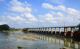
Kegalle is a large town in Sabaragamuwa Province of Sri Lanka. It is located on the Colombo–Kandy road, approximately 78 km (48 mi) from Colombo and 40 km (25 mi) from Kandy. It is the main town in the Kegalle District, which is one of two districts which comprise Sabaragamuwa Province. The town is governed by an Urban Council.
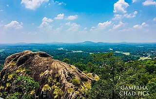
Gampaha District is one of the 25 districts of Sri Lanka, the second level administrative division of the country. It is the second most populous district of Sri Lanka after Colombo District. The district is administered by a District Secretariat headed by a District Secretary appointed by the central government of Sri Lanka. The capital of the district is the town of Gampaha. The district was carved out of the northern part of Colombo District in September 1978.

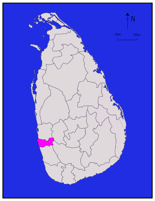
Kalutara District is one of the 25 districts of Sri Lanka, the second level administrative division of the country. The district is administered by a District Secretariat headed by a District Secretary appointed by the central government of Sri Lanka. The capital of the district is the city of Kalutara .
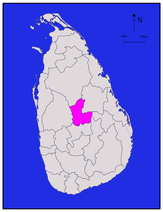
Matale District is a district in Central Province, Sri Lanka. It is one of 25 districts of Sri Lanka, the second level administrative division of the country. The district is administered by a District Secretariat headed by a District Secretary appointed by the central government of Sri Lanka. The administrative capital and largest city of the district is Matale.
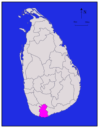
Matara is a district in Southern Province, Sri Lanka. It is one of 25 districts of Sri Lanka, the second level administrative division of the country. The district is administered by a District Secretariat headed by a District Secretary appointed by the central government of Sri Lanka.

Kurunegala is a district in North Western Province, Sri Lanka. The district is 4,812.7 km2 (1,858.2 sq mi). It consists of thirty divisional secretariats, 1,610 grama niladari divisions and 4,476 villages. It has fourteen electoral divisions, two municipal councils, nineteen urban councils, fifteen members of parliament, 47 provincial council members, fifteen ministers and 337 local council members.

Puttalam is a district situated near to the west coast of Sri Lanka. It has an area of 3,072 km2 (1,186 sq mi). Along with the Kurunegala District, it formulates the North Western Province of Sri Lanka. The district capital is Puttalam, which borders the Kala Oya and Modaragam Aru in the north, Anuradhapura District and Kurunegala District in the east, Ma Oya in the south, and the Indian Ocean in the west. Puttalam is well known for its picturesque lagoons, popular for shallow sea fishing and prawn farming activities. The town of Kalpitiya, and the Kalpitiya Peninsula, is located in this district.

Badulla District is a district in Uva Province, Sri Lanka. The entire land area of the Badulla district is 2,861 km2 (1,105 sq mi) and has a total population of 837,000. The district is bounded by the districts of Monaragala and Rathnapura on the east and south, by Ampara and Kandy districts to the north and by Nuwara Eliya and Matale to the west. Mainly the economy of the district is based on agricultural farming and livestock.

Ampara District is one of the 25 districts of Sri Lanka, the second-level administrative divisions of the country. The district is administered by a District Secretariat headed by a District Secretary appointed by the central government of Sri Lanka. The capital of the district is the town of Ampara. The district was carved out of the southern part of Batticaloa District in April 1961.
Colombo District is one of the 25 districts of Sri Lanka, the second level administrative division of the country. The district is administered by a District Secretariat headed by a District Secretary appointed by the central government of Sri Lanka. The capital of the district is the city of Colombo. The district of Colombo was officially recorded in 2016 as having the highest income on average, per household.

Jaffna District is one of the 25 districts of Sri Lanka, the second level administrative division of the country. The district is administered by a District Secretariat headed by a District Secretary appointed by the central government of Sri Lanka. The capital of the district is the city of Jaffna.

Kilinochchi District is one of the 25 districts of Sri Lanka, the second level administrative division of the country. The district is administered by a District Secretariat headed by a District Secretary appointed by the central government of Sri Lanka. The capital of the district is the town of Kilinochchi.

Batticaloa District is one of the 25 districts of Sri Lanka, the second level administrative division of the country. The district is administered by a District Secretariat headed by a District Secretary appointed by the central government of Sri Lanka. The capital of the district is the city of Batticaloa. Ampara District was carved out of the southern part of Batticaloa District in April 1961.
Mullaitivu District is one of the 25 districts of Sri Lanka, the second level administrative division of the country. The district is administered by a District Secretariat headed by a District Secretary appointed by the central government of Sri Lanka. The capital of the district is the town of Mullaitivu.

Trincomalee District is one of the 25 districts of Sri Lanka, the second level administrative division of the country. The district is administered by a District Secretariat headed by a District Secretary appointed by the central government of Sri Lanka. The capital of the district is the city of Trincomalee.

Vavuniya District is one of the 25 districts of Sri Lanka, the second level administrative division of the country. The district is administered by a District Secretariat headed by a District Secretary appointed by the central government of Sri Lanka. The capital of the district is the city of Vavuniya.

Monaragala is a district in Uva Province of Sri Lanka. It is the second largest of the 25 districts in Sri Lanka, with an area of 5,636 km2 (2,176 sq mi).

Mannar District is one of the 25 districts of Sri Lanka, the second level administrative division of the country. The district is administered by a District Secretariat headed by a District Secretary appointed by the central government of Sri Lanka. The capital of the district is Mannar, which is located on Mannar Island.
