This article needs additional citations for verification .(September 2014) |

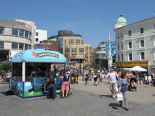
Kemptown is a small community running along the King's Cliff to Black Rock in the east of Brighton, East Sussex, England.
This article needs additional citations for verification .(September 2014) |
Kemptown is a small community running along the King's Cliff to Black Rock in the east of Brighton, East Sussex, England.

The area takes its name from Thomas Read Kemp's Kemp Town residential estate of the early 19th Century, but the one-word name now refers to an area larger than the original development and is more correctly King's Cliff. Much of the housing is slightly later but still of the Regency style, although there is also Victorian architecture and some more modern buildings. Conversions of grand Regency buildings into flats and bars has provided Kemptown with some distinctive properties; one club is housed within the Sassoon Mausoleum, the former burial chamber of Edward Sassoon.
In the nineteenth century, Kemptown was home to the Brighton Institute for Deaf and Dumb Children, at 127-132 Eastern Road (now demolished), opposite Brighton College. One of its inmates was Richard Aslatt Pearce, the first deaf ordained Anglican clergyman. [1]
Since 1950, the locality has given its name to the Brighton Kemptown parliamentary constituency, covering a wider area of eastern Brighton and at times Peacehaven.

Central Brighton is to the west of the area. Travelling inland (north) from Kemptown one finds Queen's Park above the western portion of Kemptown. Further to the east are the Bristol Estate, Craven Vale estate, and Whitehawk, sometimes collectively known as "East Brighton". Returning south to the seafront, Kemptown's easterly neighbours are Black Rock and then Roedean. Also within walking distance is Brighton Marina.
Historically known as an actors' and artists' quarter, it has a sizeable LGBT community and a network of streets with specialised shops, hotels, cafés and pubs.
There is a space available to the community in the crypt of St. George's Church, known as The Crypt, which was built with support from a European Union urban regeneration fund.
The Royal Sussex County Hospital is located in Kemptown.
Kemptown gained a railway station in 1869. The line, featuring two viaducts and a tunnel, was built at great cost partly to block the route for other railways from London. The railway lost out to bus traffic (the route from Brighton was longer than the road journey) and was closed to passenger traffic in 1933, surviving for freight until the 1970s.
There remain a number of bus services through Kemptown, and the Volk's Electric Railway passes the area along the beach.

Kemp Town Estate, also known as Kemp Town, is a 19th-century Regency architecture residential estate in the east of Brighton in East Sussex, England, UK. It consists of Arundel Terrace, Lewes Crescent, Sussex Square, Chichester Terrace, and the Kemp Town Enclosures. The estate was conceived and financed by Thomas Read Kemp, designed by Charles Busby and Amon Henry Wilds, and constructed by Thomas Cubitt. Work began in 1823 and it was completed in 1855. It has given its name to the larger Kemptown region of Brighton.

Brighton is a seaside resort and one of the two main areas of the city of Brighton and Hove in the county of East Sussex, England. It is located 47 mi (76 km) south of London. Archaeological evidence of settlement in the area dates back to the Bronze Age, Roman and Anglo-Saxon periods. The ancient settlement of "Brighthelmstone" was documented in the Domesday Book (1086). The town's importance grew in the Middle Ages as the Old Town developed, but it languished in the early modern period, affected by foreign attacks, storms, a suffering economy and a declining population. Brighton began to attract more visitors following improved road transport to London and becoming a boarding point for boats travelling to France. The town also developed in popularity as a health resort for sea bathing as a purported cure for illnesses.
Brighton and Hove is a city with unitary authority status in East Sussex, England. There are multiple villages alongside the seaside resorts of Brighton and Hove in the district. It is administered by Brighton and Hove City Council, which is currently in Labour majority control.

Peacehaven is a town and civil parish in the Lewes district of East Sussex, England. It is located above the chalk cliffs of the South Downs approximately six miles (9.7 km) east of Brighton city centre, on the A259 road. Its site coincides with the point where the Greenwich meridian crosses the English south coast. Peacehaven is next to Telscombe Cliffs, a later western extension to Peacehaven, which lies within a separate parish and has a separate town council.

Brighton Kemptown, often referred to as Brighton Kemptown and Peacehaven by local political parties, is a constituency represented in the House of Commons of the UK Parliament since 2017 by Lloyd Russell-Moyle, a Labour Co-op MP.

Kemp Town railway station was the terminus station of the Kemp Town branch line, a short branch line serving the Kemptown district of Brighton, England.

The history of Brighton is that of an ancient fishing village which emerged as a health resort in the 18th century and grew into one of the largest towns in England by the 20th century.

St George's Church is an Anglican church in the Kemptown area of Brighton, in the English city of Brighton and Hove. It was built at the request of Thomas Read Kemp, who had created and financed the Kemp Town estate on the cliffs east of Brighton in the early 19th century, and is now regarded as the parish church of the wider Kemptown area. It is a Grade II listed building.

Black Rock is an area of beach and promenade located to the west of Brighton Marina and south of Sussex Square in Kemptown in the city of Brighton and Hove. It is has one of the terminus stations of the Volk's railway, hosts a 200-year-old living wall, designated as a local wildlife site and including ninety plants such as Euonymus japonicus, and has area of vegetated shingle on the beach, recreated using plants such as Crambe maritima, Glaucium flavum and Solanum dulcamara (bittersweet) under the guidance of horticulturalists at Kew’s Millennium Seed Bank.
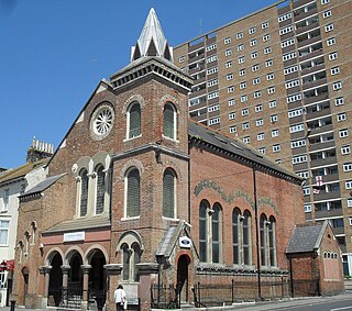
Bristol Road Methodist Church is a former Methodist place of worship in the Kemptown area of Brighton, part of the English city of Brighton and Hove. Built in 1873 to an Italian Romanesque Revival design, it served this part of eastern Brighton for more than a century until its closure in 1989, after which it became a recording studio. It is owned by Brighton College, a private school based nearby. The building has been listed at Grade II in view of its architectural importance.

Brighton and Hove, a city on the English Channel coast in southeast England, has a large and diverse stock of buildings "unrivalled architecturally" among the country's seaside resorts. The urban area, designated a city in 2000, is made up of the formerly separate towns of Brighton and Hove, nearby villages such as Portslade, Patcham and Rottingdean, and 20th-century estates such as Moulsecoomb and Mile Oak. The conurbation was first united in 1997 as a unitary authority and has a population of about 253,000. About half of the 20,430-acre (8,270 ha) geographical area is classed as built up.
Thomas Lainson, FRIBA was a British architect. He is best known for his work in the East Sussex coastal towns of Brighton and Hove, where several of his eclectic range of residential, commercial and religious buildings have been awarded listed status by English Heritage. Working alone or in partnership with two sons as Lainson & Sons, he designed buildings in a wide range of styles, from Neo-Byzantine to High Victorian Gothic; his work is described as having a "solid style, typical of the time".

The Pelham Institute is a former working men's club and multipurpose social venue in the Kemptown area of Brighton, part of the English coastal city of Brighton and Hove. Built in 1877 by prolific local architect Thomas Lainson on behalf of the Vicar of Brighton, the multicoloured brick and tile High Victorian Gothic building catered for the social, educational and spiritual needs of the large working-class population in the east of Brighton. After its closure it hosted a judo club, but is now in residential use as flats owned by a housing association. English Heritage has listed the building at Grade II for its architectural and historical importance.

Montpelier is an inner suburban area of Brighton, part of the English city and seaside resort of Brighton and Hove. Developed together with the adjacent Clifton Hill area in the mid-19th century, it forms a high-class, architecturally cohesive residential district with "an exceptionally complete character". Stucco-clad terraced housing and villas predominate, but two of the city's most significant Victorian churches and a landmark hospital building are also in the area, which lies immediately northwest of Brighton city centre and spreads as far as the ancient parish boundary with Hove.

Adelaide Crescent is a mid-19th-century residential development in Hove, part of the English city and seaside resort of Brighton and Hove. Conceived as an ambitious attempt to rival the large, high-class Kemp Town estate east of Brighton, the crescent was not built to its original plan because time and money were insufficient. Nevertheless, together with its northerly neighbour Palmeira Square, it forms one of Hove's most important architectural set-pieces. Building work started in 1830 to the design of Decimus Burton. The adjacent land was originally occupied by "the world's largest conservatory", the Anthaeum; its collapse stopped construction of the crescent, which did not resume until the 1850s. The original design was modified and the crescent was eventually finished in the mid-1860s. Together with the Kemp Town and Brunswick Town estates, the crescent is one of the foremost pre-Victorian residential developments in the Brighton area: it has been claimed that "outside Bath, [they] have no superior in England". The buildings in the main part of Adelaide Crescent are Grade II* listed. Some of the associated buildings at the sea-facing south end are listed at the lower Grade II.
The Brighton Herald was a weekly newspaper covering the boroughs of Brighton and Hove in southeast England. Founded in 1806 as the first newspaper in the fashionable seaside resort of Brighton, it survived until 1971 and was one of England's "leading provincial weekly" newspapers—being the first publication in the country to report several important international events, such as Napoleon's escape and the start of the July Revolution. Based in the centre of Brighton throughout its 165-year existence, it moved in 1934 to new premises at Pavilion Buildings, near the Royal Pavilion.
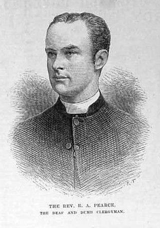
Richard Aslatt Pearce was the first deaf person to be ordained as an Anglican clergyman. He was educated via the sign language of his era, he became Chaplain to the Deaf and Dumb, and he fulfilled this duty in the Southampton area for the rest of his life. In 1885 he was introduced to Queen Victoria, who then ordered the Royal Commission on the Blind, the Deaf and Dumb and Others of the United Kingdom, 1889.
Kemp Town branch line was a railway line running from Brighton to Kemptown in the UK that operated between 1869 and 1971. It ran from a junction off the Brighton to Lewes line between London Road and Moulsecoomb stations, to Kemp Town railway station. It opened in 1869 and was expensive to construct, requiring a tunnel and a large viaduct.
City of Brighton and Hove | |||||||||||||
|---|---|---|---|---|---|---|---|---|---|---|---|---|---|
| Topics | |||||||||||||
| Events | |||||||||||||
| Culture | |||||||||||||
| Politics | |||||||||||||
| Transport |
| ||||||||||||
| Media | |||||||||||||
| Sport |
| ||||||||||||
| Buildings | |||||||||||||
| Parks | |||||||||||||
| Areas |
| ||||||||||||