Some coastal areas of the Northern Kimberly are formed of basalt, and the Mitchell Plateau and Bougainville Peninsula are overlain by a layer of bauxiticduricrust.[6]
The southern Dampierland region, which includes the Dampier Peninsula and the coastal plain extending to the southwest, are on deposits of red sand. The topography of Dampierland is mostly gentle, with coastal dunes and lagoons.[6]
The ecoregion has a tropical savanna climate. Temperatures are high throughout the year, and monthly maximum averages range from 25º to 35º C. Rainfall is highly seasonal, occurring with the summer monsoons from October to March, followed by a long dry season during the rest of the year. Rainfall is highest in the coastal north of the ecoregion, and lower in the south and towards the interior. The Mitchell Plateau in the north receives 1,400 mm annually, while Broome in the southwest receives around 600 mm.[2]
Flora
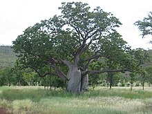
A boab tree in February
The vegetation is mostly savanna and open woodland, which vary in species composition with rainfall, underlying soils, and exposure to fires. Other vegetation types include wetlands and enclaves of monsoon rainforest.[2]
Woodlands and savannas
Woodland of bloodwood eucalypts (Corymbia spp.) is widespread on sand and loam soils. Boab (Adansonia gregorii) is a distinctive woodland tree that favours sandy soils. Darwin stringybark (Eucalyptus tetrodonta) and Darwin woollybutt (E. miniata) predominate where soils are richer and rainfall is higher. The trees are evergreen and form an open canopy 5 to 15 metres high. The understory is mostly tall grass, with species of Sorghum, Heteropogon, Themeda, Chrysopogon, Aristida, and Eriachne. In parts of Northern Kimberly, the palm Livistona eastonii forms a dense sub-canopy in the woodlands.[2]
River valley lowlands with fine-textured clay and clay-loam soils are home to open woodlands characterized by trees of the genera Terminalia and Bauhinia, and grasslands of Chrysopogon, Aristida, and Dichanthium, with species of Xerochloa in wetter areas. Many of these woodlands and grasslands have been converted to farmland.[2]
Pindan
Pindan is a plant community found on the Dampier Peninsula and elsewhere the southwestern portion of the ecoregion, typically in areas with red sandy soils. Pindan is a low-canopied open woodland with trees 3 to 8 meters high. The dominant species are wattle, including Acacia eriopoda, A. tumida, A. platycarpa, and A. colei. Occasional bloodwoods emerge above the wattle canopy.[2]
Monsoon rainforests
Pockets of monsoon rainforest are found on scattered sites, generally within 150 km of the coast. There are approximately 1500 monsoon rainforest patches totaling 7,000 hectares (ha). The average patch is less than four hectares. Only 3% exceed 20 ha, and the largest is 200 ha. Monsoon rainforest is composed of semi-deciduous or deciduous trees which lose their leaves towards the end of the dry season ("raingreen"). Woody vines are common, and they climb into the tree canopies; lower-canopied monsoon rainforests are also known as monsoon vine thickets. Understory plants include low trees, shrubs and vines. Monsoon rainforest is generally fire-intolerant, in contrast to the surrounding savanna and woodlands which are adapted to frequent fires. Trees and shrubs of the monsoon rainforest often have fleshy fruits, which are eaten and dispersed by birds, bats, and mammals. Monsoon rainforests are found behind coastal dunes, on hillsides and scree slopes, at the edges of swamps and rivers, and in gorges and gullies. Rainforests have a distinct flora from the adjacent savannas and woodlands, with many ancient Gondwanian plants, along with plants characteristic of the Australasian and Indomalayan tropics.[6]
About 230 species of plants are endemic to the ecoregion, along with six endemic species of mammals, two endemic bird species, 31 endemic reptile species, and 16 endemic fish species.
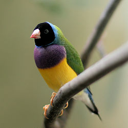
The black grasswren (Amytornis housei) and white-quilled rock pigeon (Petrophassa albipennis) are endemic. The black grasswren lives in hummock grasslands in the sandstone hills of Northern Kimberley. The ecoregion is home to the near-threatened Gouldian finch (Erythrura gouldiae). The purple-crowned fairywren (Malurus coronatus) is threatened by habitat loss, as its riparian habitat, particularly along the Ord and Fitzroy rivers, has been trampled by cattle and converted to agriculture.[2]
The ecoregion's wetlands are important habitats for migratory and resident water birds. Glossy ibis (Plegadis falcinellus) and magpie goose (Anseranas semipalmata) are the most abundant. The Ord River Floodplain and Parry Creek floodplain, Eighty Mile Beach, and Roebuck Bay are Ramsar sites. Lakes Argyle and Kununurra are artificial reservoirs on the Ord River which have become important dry-season refuges for birds. The rocky northern coast and offshore islands are home to colony breeding sites for herons, cormorants, and other seabirds.[2]
Threats to the ecoregion's wildlife include: habitat loss from converting land to agriculture and pasture; trampling and overgrazing by livestock cattle and feral cattle, donkeys, pigs, and rabbits; changes to the fire regime from replacing Aboriginal fire practices (small, frequent, and deliberately-set small fires) with widespread fire suppression resulting in larger late-season fires; and the introduction of exotic predators including house cats and foxes. Several introduced plants have become widespread weeds, displacing native plants and disrupting the region's fire and hydrologic cycles and food sources for native animals. These plants include rough cocklebur (Xanthium strumarium), parkinsonia (Parkinsonia aculeata), bellyache bush (Jatropha gossypifolia), castor bean plant (Ricinus communis), and stinking passionflower (Passiflora foetida).[2]
Tropical and subtropical moist broadleaf forests (TSMF), also known as tropical moist forest, is a subtropical and tropical forest habitat type defined by the World Wide Fund for Nature.
The Queensland tropical rain forests ecoregion covers a portion of the coast of Queensland in northeastern Australia and belonging to the Australasian realm. The forest contains the world's best living record of the major stages in the evolutionary history of the world's land plants, including most of the world's relict species of plants from the ancient supercontinent of Gondwana. The history of the evolution of marsupials and songbirds is also well represented.
The Kimberley is the northernmost of the nine regions of Western Australia. It is bordered on the west by the Indian Ocean, on the north by the Timor Sea, on the south by the Great Sandy and Tanami deserts in the region of the Pilbara, and on the east by the Northern Territory.
The Top End of Australia's Northern Territory is a geographical region encompassing the northernmost section of the Northern Territory, which aside from the Cape York Peninsula is the northernmost part of the Australian continent. It covers a rather vaguely defined area of about 245,000 km² behind the northern coast from the Northern Territory capital of Darwin across to Arnhem Land with the Indian Ocean on the west, the Arafura Sea to the north, and the Gulf of Carpentaria to the east, and with the almost waterless semi-arid interior of Australia to the south, beyond the huge Kakadu National Park.
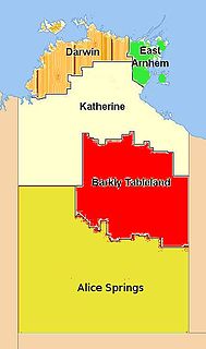
The Barkly Tableland is a rolling plain of grassland in Australia. It runs from the eastern part of the Northern Territory into western Queensland. It is one of the five regions in the Northern Territory and covers 283,648 square kilometres (109,517 sq mi), 21% of the Northern Territory. The Barkly Tableland runs parallel to the southern shore of the Gulf of Carpentaria, from about Mount Isa, Queensland to near Daly Waters.
The Upper Gangetic Plains moist deciduous forests is a tropical and subtropical moist broadleaf forests ecoregion of northern India.
The Sri Lanka dry-zone dry evergreen forests are a tropical dry broadleaf forest ecoregion of the island of Sri Lanka.
The Northern Congolian forest–savanna mosaic is a forest and savanna ecoregion of central Africa. It extends east and west across central Africa, covering parts of Cameroon, Central African Republic, Democratic Republic of the Congo, South Sudan, and Uganda. It is part of the belt of transitional forest-savanna mosaic that lie between Africa's moist equatorial Guineo-Congolian forests and the tropical dry forests, savannas, and grasslands to the north and south.
The Arnhem Land tropical savanna is a tropical and subtropical grasslands, savannas, and shrublands ecoregion in Australia's Northern Territory.
The Carpentaria tropical savanna is a tropical and subtropical grasslands, savannas, and shrublands ecoregion in northern Australia.
Pindan is a name given to the red-soil country of the south-western Kimberley region of Western Australia. The term comes from a local language and applies both to the soil and to the vegetation community associated with it.
The Trans Fly savanna and grasslands are a lowland ecoregion on the south coast of the island of New Guinea in both the Indonesian and Papua New Guinean sides of the island. With their monsoon and dry season climate these grasslands are quite different from the tropical rainforest that covers most of the island and resemble the landscape of northern Australia which lies to the south.
The Victoria Plains tropical savanna is a tropical and subtropical grasslands, savannas, and shrublands ecoregion in northwestern Australia.
The Ethiopian montane forests is a tropical moist broadleaf forest ecoregion in eastern Africa. It covers the middle elevations of the Ethiopian Highlands in Ethiopia and extends into neighboring Eritrea, Sudan, Djibouti, and Somaliland. The ecoregion includes distinctive Afromontane forests, woodlands, grasslands, and shrublands. The ecoregion's biodiversity is threatened by deforestation, conversion to agriculture, and overgrazing.
The southern Congolian forest–savanna mosaic is an ecoregion that covers a large area of the southern Democratic Republic of the Congo and northeastern Angola. Its rich blend of habitats provides key insights into the biogeography of central Africa with the extensive climatic variation that it has been experiencing for the last 10 million years. The human population is not high.
The Madeira-Tapajós moist forests (NT0135) is an ecoregion in the Amazon basin. It is part of the Amazon biome. The ecoregion extends southwest from the Amazon River between its large Madeira and Tapajós tributaries, and crosses the border into Bolivia. In the south it transitions into the cerrado biome of Mato Grosso. In the state of Rondônia it contains some of the most degraded land of the Amazon basin.
The Solimões-Japurá moist forests (NT0163) is an ecoregion in northwest Brazil and eastern Peru and Colombia in the Amazon biome. It has a hot climate with high rainfall throughout the year, and holds one of the most diverse collections of fauna and flora in the world. The ecoregion is relatively intact.
The Uatuma–Trombetas moist forests (NT0173) is an ecoregion in northwest Brazil in the Amazon biome. It covers the Amazon basin north of the Amazon River from close to the Atlantic Ocean to the Rio Negro west of Manaus. The ecoregion is relatively intact, although it has been damaged along the main rivers and around population centers.
The Western Congolian forest–savanna mosaic is an ecoregion of Angola, Democratic Republic of the Congo, Republic of the Congo, and Gabon.
The Victoria Basin forest–grassland mosaic is an ecoregion that lies mostly in Uganda and extends into neighboring countries. The ecoregion is centered north and west of Lake Victoria, with an outlier on the border of Ethiopia and South Sudan.
References
1 2 Eric Dinerstein, David Olson, et al. (2017). An Ecoregion-Based Approach to Protecting Half the Terrestrial Realm, BioScience, Volume 67, Issue 6, June 2017, Pages 534–545; Supplemental material 2 table S1b.
1 2 3 4 5 6 7 Kenneally, Kevin F. (2018). Kimberley Tropical Monsoon Rainforests of Western Australia: Perspectives on Biological Diversity. Journal of the Botanical Research Institute of Texas: 149 – 228. 2018.
1 2 UNEP-WCMC (2020). Protected Area Profile for Australia from the World Database of Protected Areas, September 2020. Available at: www.protectedplanet.net
This page is based on this Wikipedia article Text is available under the CC BY-SA 4.0 license; additional terms may apply. Images, videos and audio are available under their respective licenses.