The Viperinae, or viperines, are a subfamily of vipers endemic to Europe, Asia and Africa. They are distinguished by their lack of the heat-sensing pit organs that characterize their sister group, the subfamily Crotalinae. Currently, 13 genera are recognized. Most are tropical and subtropical, although one species, Vipera berus, even occurs within the Arctic Circle. Like all vipers, they are venomous.

Kitale is an agricultural town in northern Rift Valley Kenya situated between Mount Elgon and the Cherangany Hills at an elevation of around 1,900 metres (6,200 ft). Its population is 106,187 as of 2009. Kitale is the headquarter town of Trans-Nzoia County. Kitale is reachable by air through Kitale Airport. The postal code for Kitale is 30200.
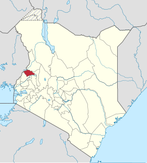
Trans-Nzoia County is a county in the former Rift Valley Province, Kenya, located between the Nzoia River and Mount Elgon, 380 km northwest of Nairobi. At its centre is the town of Kitale which is the capital and largest town. The county borders Bungoma to the west, Uasin Gishu and Kakamega to the south, Elgeyo-Marakwet to the east, West Pokot to the north and the republic of Uganda to the Northwest. Trans Nzoia covers an area of 2495.5 square kilometres.

Cherokee is a census-designated place (CDP) in Swain and Jackson counties in Western North Carolina, United States, within the Qualla Boundary land trust. Cherokee is located in the Oconaluftee River Valley around the intersection of U.S. Routes 19 and 441. As of the 2010 census, the CDP had a population of 2,138. It is the capital of the federally recognized Eastern Band of Cherokee Indians, one of three recognized Cherokee tribes and the only one in North Carolina.

Melbourne Zoo is a zoo in Melbourne, Australia. It is located within Royal Park in Parkville, approximately 4 kilometres (2.5 mi) north of the centre of Melbourne. It is the primary zoo serving Melbourne. The zoo contains more than 320 animal species from Australia and around the world, and is accessible via Royal Park station on the Upfield railway line, and is also accessible via tram routes 58 and 19, as well as by bicycle on the Capital City Trail. Bicycles are not allowed inside the zoo itself.

The Australian National Botanic Gardens (ANBG) is a heritage-listed botanical garden located in Acton, Canberra, in the Australian Capital Territory, Australia. Established in 1949, the Gardens is administered by the Australian Government's Department of Agriculture, Water and the Environment. The botanic gardens was added to the Commonwealth Heritage List on 22 June 2004.

Topanga State Park is a California state park located in the Santa Monica Mountains, within Los Angeles County, California. It is part of the Santa Monica Mountains National Recreation Area.

Kericho is the biggest town in Kericho County located in the highlands west of the Kenyan Rift Valley. Standing on the edge of the Mau Forest, Kericho has a warm and temperate climate making it an ideal location for agriculture and in particular, the large scale cultivation of tea.
Kapenguria is a town lying north east of Kitale on the A1 road in Kenya. Kapenguria is capital of the West Pokot County. Kapenguria forms a municipality with an urban population of 13,000 and a total population of 56,000.

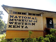
The National Museums of Kenya (NMK) is a state corporation that manages museums, sites and monuments in Kenya. It carries out heritage research, and has expertise in subjects ranging from palaeontology, archeology, ethnography and biodiversity research and conservation. Its headquarters and the National Museum are located on Museum Hill, near Uhuru Highway between Central Business District and Westlands in Nairobi. The National Museum of Kenya was founded by the East Africa Natural History Society (E.A.N.H.S.) in 1910; the Society's main goal has always been to conduct an ongoing critical scientific examination of the natural attributes of the East African habitat. The museum houses collections, and temporary and permanent exhibits. Today the National Museum of Kenya manages over 22 regional museums, many sites, and monuments across the country.
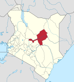
Isiolo County is a county in the former Eastern Province of Kenya. Its population is 268,002 and its capital and largest city is Isiolo. Isiolo is also the Least Populated County in Kenya. Isiolo County is to be the first county to be developed as part of the Kenya Vision 2030 program. Other upcoming urban centres are: Garbatulla, Modogashe, Kinna, Merti and Oldonyiro.

Baringo County is one of the 47 Counties of Kenya. It is located in the former Rift Valley Province. Its headquarters and largest town is Kabarnet. The county is home to Lake Baringo.

Jomo Kenyatta University of Agriculture and Technology (JKUAT) is a public university that is situated in Juja, 36 kilometres northeast of Nairobi, along the Nairobi-Thika SuperHighway, off Exit 15. .It offers courses in Technology, Engineering, Science, Commerce, Management and Building sciences. The university has a strong research interest in the areas of biotechnology and engineering. Notable alumni include Dr. Paul Chepkwony, the first Governor of Kericho County in Kenya and a former lecturer, Emma Miloyo, a prominent Kenyan architect and the first female President of the Architectural Association of Kenya, as well as Aden Duale, the former Leader of Majority in the 11th Kenyan Parliament among others.
Moi's Bridge is a small town that has its roots both in Uasin Gishu County, Trans Nzoia County and Kakamega County, Kenya. It is a town that has since grown as an agricultural center with the third largest NCPB in East Africa. Moi's Bridge is an electoral ward of the Soy Constituency and Uasin Gishu County. It is an important Kenyan area, often named as the 'bread basket' of Kenya. Moi's Bridge is also a location in the Soy division of Uasin Gishu District.

The Stamford Museum & Nature Center, located in Stamford, Connecticut, is an art, history, nature, and agricultural sciences museum. The property covers 118 acres beginning about half a mile north of the Merritt Parkway. It was originally a private estate.
Birdsacre Sanctuary, also known as Stanwood Wildlife Sanctuary, is an historic house museum and wildlife sanctuary at 289 High Street in Ellsworth, Maine, United States. The core of the property is a 40-acre (16 ha) parcel owned by the pioneering Maine ornithologist Cordelia Stanwood, whose home was opened as a museum in 1960, and is listed on the National Register of Historic Places in 1973. Stanwood's homestead was extensively damaged by an arsonist-set fire in 2014. The sanctuary, now 200 acres (81 ha), includes trails, an orchard, and a nature center that showcases a fine art and nature collection, including Cordelia J. Stanwood's avian field-notes and extensive photographic collection.

Thimlich Ohinga is a complex of stone-built ruins in Migori county, Nyanza Kenya, in East Africa. It is the largest one of 138 sites containing 521 stone structures that were built around the Lake Victoria region in Kenya. These sites are highly clustered. The main enclosure of Thimlich Ohinga has walls that vary from 1 to 3 meters in thickness, and 1 to 4.2 meters in height. The structures were built from undressed blocks, rocks, and stones set in place without mortar. The densely packed stones interlock. The site is believed to be more than 550 years old.
The Kisumu–Kakamega–Webuye–Kitale Road, is a rural road in Kenya. The road links Kisumu, in Kisumu County, to the towns of Kakamega, in Kakamega County, Webuye in Bungoma County, and Kitale in Trans-Nzoia County.

Komodo Indonesian Fauna Museum and Reptile Park, is a zoological museum located within the Taman Mini Indonesia Indah (TMII) compound, in East Jakarta, Indonesia. The museum specialized on presenting various collection of the fauna of Indonesia, especially endemic animals of Indonesia, to provides information and education on Indonesian animal diversity. The Komodo Fauna Museum is located on southeast corner of Taman Mini Indonesia Indah cultural park.
The Kisumu–Chemelil–Muhoroni Road, is a road in Kenya, that links the city of Kisumu, to the towns of Miwani, Kibigori, Chemelil, all in Kisumu County, to the town of Muhoroni, also in Kisumu County. The road is sometimes referred to as the Nyanza Sugar Belt Road.