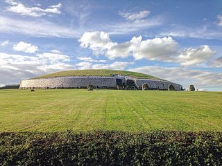
Newgrange is a prehistoric monument in County Meath in Ireland, located on a rise overlooking the River Boyne, 8 kilometres (5.0 mi) west of Drogheda. It is an exceptionally grand passage tomb built during the Neolithic Period, around 3200 BC, making it older than Stonehenge and the Egyptian pyramids. It is aligned on the winter solstice sunrise. Newgrange is the main monument in the Brú na Bóinne complex, a World Heritage Site that also includes the passage tombs of Knowth and Dowth, as well as other henges, burial mounds and standing stones.

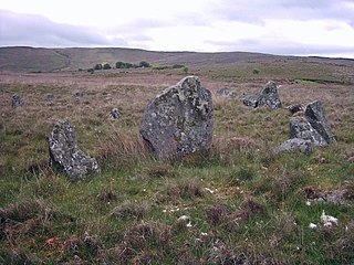
Arbor Low is a well-preserved Neolithic henge in the Derbyshire Peak District, England. It lies on a Carboniferous Limestone plateau known as the White Peak area. The monument consists of a stone circle surrounded by earthworks and a ditch.

A stone circle is a ring of standing stones. Most are found in Northwestern Europe – especially in Britain, Ireland, and Brittany – and typically date from the Late Neolithic and Early Bronze Age, with most being built from 3000 BC. The best known examples include those at the henge monument at Avebury, the Rollright Stones, and elements within the ring of standing stones at Stonehenge. Scattered examples exist from other parts of Europe. Later, during the Iron Age, stone circles were built in southern Scandinavia.

Beaghmore is a complex of early Bronze Age megalithic features, stone circles and cairns, 8.5 miles north west of Cookstown, County Tyrone in Northern Ireland, on the south-east edge of the Sperrin Mountains.

A stone row or stone alignment is a linear arrangement of megalithic standing stones set at intervals along a common axis or series of axes, usually dating from the later Neolithic or Bronze Age. Rows may be individual or grouped, and three or more aligned stones can constitute a row.

Knowth is a prehistoric monument overlooking the River Boyne in County Meath, Ireland. It comprises a large passage tomb surrounded by 17 smaller tombs, built during the Neolithic era around 3200 BC. It contains the largest assemblage of megalithic art in Europe. Knowth is part of the Brú na Bóinne complex, a World Heritage Site that also includes the similar passage tombs of Newgrange and Dowth.
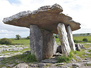
Poulnabrone dolmen is a large dolmen located in the Burren, County Clare, Ireland. Situated on one of the most desolate and highest points of the region, it comprises three standing portal stones supporting a heavy horizontal capstone, and dates to the Neolithic period, with estimates to between 4200 BC and 2900 BC. Although not the largest, it is the best known of the approximately 172 dolmens in Ireland.

The Callanish IV stone circle is one of many megalithic structures around the better-known Calanais I on the west coast of the Isle of Lewis, in the Outer Hebrides, Scotland. It is a scheduled monument and its official name is Sron a'Chail. The site was first surveyed and recorded by RCAHMS in 1914 and again in 2009, with another survey in the 1970s by other archaeologists, but no known archaeological excavations have taken place at the stones.

Carrigagulla is a megalithic complex 2.9 km north-east of Ballinagree, County Cork, Ireland.

Glantane East is a megalithic complex situated 6.4 kilometres (4.0 mi) from Millstreet, County Cork, Ireland. It is set in the Keel River valley on the north-west upper slopes of Musherabeg mountain, in the townland of Glantane. The complex includes a wedge tomb, two stone circles and a pair of stone alignments.
Drombeg stone circle is a small axial stone circle located 2.4 km (1.5 mi) east of Glandore, County Cork, Ireland.

The Uragh Stone Circle is an axial five-stone circle located near Gleninchaquin Park, County Kerry, Ireland. The Bronze Age site includes a multiple stone circle and some boulder burials.
Goodaver, Goodaver stone circle or Goodaver circle is a stone circle located in the parish of Altarnun, near Bolventor on Bodmin Moor in Cornwall.
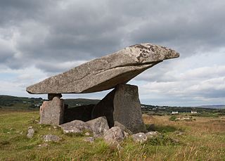
Kilclooney More is a townland in the northwest of Ireland in coastal County Donegal. It is situated halfway between Narin and Ardara at the R261 on the Loughrea Peninsula.

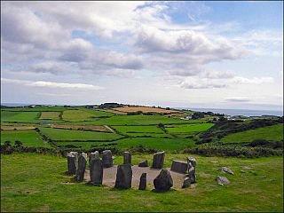
An axial stone circle is a megalithic ring of stones of a particular design found in County Cork and County Kerry in southwest Ireland. Archaeologists have found it convenient to consider the axial five-stone circle and axial multiple-stone circle separately. The circle has an approximate axis of symmetry aligned in a generally northeast–southwest direction. The stone at the southwest side of the circle, rather than being an upright orthostat like all the rest, is a slab lying horizontally with its long thin edge along the circumference of the ring. Because it marks the axis of the circle it is called the axial stone.

Kealkill stone circle is a Bronze Age axial five-stone circle located just outside the village of Kealkill, County Cork in southwest Ireland. When it was excavated in 1938 it was thought the crucial axial stone indicated an alignment to the north, contrary to the general alignment of such stone circles to the southwest. However, later archaeologists have thought it is the comparatively insignificant stone to the southwest that is the axial stone. There are two associated standing stones nearby, one of which had fallen and was re-erected in 1938.
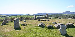
Tomnaverie stone circle is a recumbent stone circle set on the top of a small hill in lowland northeast Scotland. Construction started from about 2500 BC, in the Bronze Age, to produce a monument of thirteen granite stones including a massive 6.5-ton recumbent stone lying on its side along the southwest of the circle's perimeter. Within the 17-metre (56 ft) circle are kerb stones encircling a low 15-metre (49 ft) ring cairn but the cairn itself no longer exists.

Dooey's Cairn, or Ballymacaldrack Court Tomb, is a prehistoric site of the Neolithic period, situated near Dunloy, in County Antrim, Northern Ireland.