Kyhv Peak

Last updated

Kyhv Peak
Squaw Peak Provo, Utah.JPG
Kyhv Peak during a Fall sunset, October 2012
Highest point
Elevation 7,865 ft (2,397 m)
Coordinates 40°16′18″N111°36′59″W / 40.2717073°N 111.6162701°W / 40.2717073; -111.6162701
Naming
Etymology Variation of a Northern Ute word for "mountain." [1]
Pronunciation KIVE
Geography
CountryUnited States
State Utah
City Provo
Parent range Wasatch Range

Kyhv Peak (KIVE, like "dive", from a Ute word for "mountain") [1] is a peak in the Wasatch Mountain range. It was once known as "Squaw Peak" and was officially renamed in 2022 as part of a federal order to remove the ethnic slur "squaw" from federally owned places in the United States. [2]

Contents

Geography

Kyhv Peak is located within the Squaw Benchmark ridge which runs North to South in the Uintah Mountain Range in Utah. The peak is specifically located north and east of Provo, Utah at the mouth of Rock Canyon. [3] It is a relatively flat peak that reaches 7,876 feet above sea level at its highest point.

There are two campgrounds and several trail heads available for recreation around the peak, one of which is marked by a stone with "Squaw Peak Trail" carved into it. [3] As the trail heads are located further from paved roads than other trails to comparable peaks in the area, it is not as popular of a hike as others in Rock Canyon.

The peak appears on the "Bridal Veil Falls" map on record with the U.S. Geologic Survey. Although as of September 8, 2022 the peak is titled "Kyhv Peak" on the U.S. Geologic Survey website, it still appears as "Squaw Mountain" on the map. [4]

History

Kyhv Peak as viewed from the mouth of Rock Canyon, showing some of the distinctly visible geological layers RockCanyonNorthSideSpring2006.jpg
Kyhv Peak as viewed from the mouth of Rock Canyon, showing some of the distinctly visible geological layers

Kyhv Peak, previously known as Squaw Peak, has a history among the white settlers and local indigenous people of the Utah Valley area. [5] While the names of most prominent geological locations in Utah come from the indigenous language of the area, there is no specific indigenous language behind the name “Squaw Peak." [6] The use of the word "squaw" originated with a word used by Northeastern native tribes that was then adopted by settlers moving west. It became synonymous with women involved in prostitution. Other native activists have associated the use of the word with increasing trends of violence against native women. [7] This association caused most of the push toward the name change.

The Northern Ute tribe considered Utah Valley and the area around Utah Lake to be their most permanent home and the tribe continues today to list Utah Valley as its primary homeland. [8] Though the tribe had mostly friendly relations with Spanish and American explorers throughout history, Latter-day Saint settlement in Utah Valley caused tensions. While Latter-day Saint settlers were counseled to have friendly relations with Utes and other local tribes and even to seek conversion, the reality of settlement caused more similarities between Latter-day Saint and Ute relations to other white and settler relations of the time rather than differences. [9] [ page needed ] Settlers built a fort in what is now Provo directly on top of Ute hunting trails. [8] Utes retaliated by raiding the fort and stealing cattle and horses. There was a skirmish in the Provo area in 1850 between white settlers and indigenous people that led to the legend of the original naming of the peak. [1] The story involves Ute chief Old Elk and an incident referred to as the "Battle of Provo River." As Ute warriors retreated with their wives and children into Rock Canyon for safety, legend has it that Old Elk's wife fell from the peak and died, and locals began calling the peak "Squaw Peak." [1] This legend has not been verified as historically accurate, but the name was given and used by the locals from that point on. [10]

Further skirmishes between Latter-day Saint settlers and Ute tribe members eventually led to the Walker War in 1853. [8]

Repeak Committee and renaming efforts

Kyhv Peak, August 2007 Kyhv Peak, view from Provo, Utah.jpg
Kyhv Peak, August 2007

Changing the name of "Squaw Peak" was first officially mentioned at a Provo Women's Day Lecture Series in March 2017 by Provo mayor John Curtis. He said he was working with a committee towards changing the name of the peak as the word "squaw" is considered offensive to native tribes. Since the peak is owned by the federal government, Curtis admitted that Provo city's efforts were not guaranteed to result in a name change. [11]

Native activists such as Eugene Tapahe made statements in support of the name change at this time. [11]

In November 2017, a "Repeak Committee" made up of local activists, including indigenous people, came to prominence. The committee's first official act was presenting about the effort to rename "Squaw Peak" at Utah Valley University's Diversity Day Lecture Series.[ citation needed ] The group and their efforts were also featured in several local newspapers, including Provo's Daily Herald , [7] the Deseret News , [10] The Salt Lake Tribune , [12] and Brigham Young University's Daily Universe . [13] [11] [2]

A view of Kyhv Peak from Lavell Edwards Stadium, September 2013 Squaw Peak from Lavell Edwards Stadium (Provo, Utah).jpg
A view of Kyhv Peak from Lavell Edwards Stadium, September 2013

In 2020, a Utah legislative committee met to streamline and localize the process of indigenous tribes applying to have geologic features with names related to indigenous languages renamed. Several members of the Repeak Committee were involved in bringing the bill before the Utah legislature. [12] While the job of renaming geologic features is generally left up to petition approval by the Board of Geographic Names, this process can often take years. [14] the resulting bill involved the Division of Indian Affairs in this process and specifically mentioned the use of the name "squaw" as a reason to change the name of a place. [15] The bill received unanimous approval by the Utah Legislature on October 19, 2020. [13] Several polls during this time period suggested many indigenous people were not offended by a similar exonym, "redskin." [16]

On September 1, 2022, the U.S. Department of the Interior announced that the word "squaw" would be removed from all federal use, pushing forward movements to rename locations all over the United States. [7] The announcement including approving over 600 proposals for name changes, including changing "Squaw Peak to "Kyhv Peak." [2] The name was officially changed on the website of the U.S. Geologic Survey Department on September 9, 2022. [4] This new name has ties to the Northern Ute language, specifically a variation of the Northern Ute word for "mountain." [1]

See also

Related Research Articles

<span class="mw-page-title-main">Provo, Utah</span> City in Utah, United States

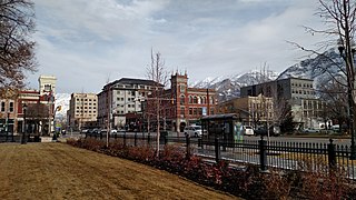
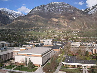
Provo is a city in and the county seat of Utah County, Utah, United States. It is 43 miles (69 km) south of Salt Lake City along the Wasatch Front, and lies between the cities of Orem to the north and Springville to the south. With a population at the 2020 census of 115,162, Provo is the fourth-largest city in Utah and the principal city in the Provo-Orem metropolitan area, which had a population of 526,810 at the 2010 census. It is Utah's second-largest metropolitan area after Salt Lake City.

<span class="mw-page-title-main">Yokuts Valley, California</span> Community in Fresno County, California

Yokuts Valley, formerly "Squaw Valley" is a unincorporated community located in Fresno County, California, at the foothills of the Sierra Nevada on State Route 180 just below Kings Canyon National Park.

<span class="mw-page-title-main">Utah Lake</span> Freshwater lake in Utah County, Utah, United States

Utah Lake is a shallow freshwater lake in the center of Utah County, Utah, United States. It lies in Utah Valley, surrounded by the Provo-Orem metropolitan area. The lake's only river outlet, the Jordan River, is a tributary of the Great Salt Lake. Evaporation accounts for 42% of the lake's outflow, which leaves the lake slightly saline. The elevation of the lake is at 4,489 feet (1,368 m) above sea level. If the lake's water level rises above that, the pumps and gates on the Jordan River are left open. Recently the lake has been at a lower level because of a drought.

<span class="mw-page-title-main">Wasatch Range</span> Sub-range of the Rocky Mountains in the western United States

The Wasatch Range or Wasatch Mountains is a mountain range in the western United States that runs about 160 miles (260 km) from the Utah-Idaho border south to central Utah. It is the western edge of the greater Rocky Mountains, and the eastern edge of the Great Basin region. The northern extension of the Wasatch Range, the Bear River Mountains, extends just into Idaho, constituting all of the Wasatch Range in that state.

<span class="mw-page-title-main">Mount Timpanogos</span> Mountain in Utah, United States

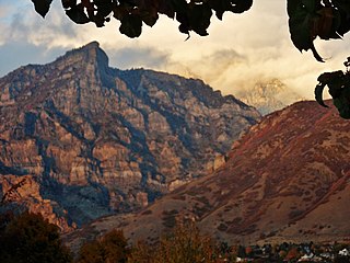
Mount Timpanogos, often referred to as Timp, is the second-highest mountain in Utah's Wasatch Range. Timpanogos rises to an elevation of 11,752 ft (3,582 m) above sea level in the Uinta-Wasatch-Cache National Forest. With 5,270 ft (1,610 m) of topographic prominence, Timpanogos is the 47th-most prominent mountain in the contiguous United States.

<span class="mw-page-title-main">Ute people</span> Native American people in the United States

Ute are the indigenous, or Native American people, of the Ute tribe and culture among the Indigenous peoples of the Great Basin. They had lived in sovereignty in the regions of present-day Utah and Colorado.

Chief Walkara was a Shoshone leader of the Utah Indians known as the Timpanogo and Sanpete Band. It is not completely clear what cultural group the Utah or Timpanogo Indians belonged to, but they are listed as Shoshone. He had a reputation as a diplomat, horseman and warrior, and a military leader of raiding parties, and in the Wakara War.

The English word squaw is an ethnic and sexual slur, historically used for Indigenous North American women. Contemporary use of the term, especially by non-Natives, is considered derogatory, misogynist, and racist.

<span class="mw-page-title-main">Ute Mountain Ute Tribe</span> Reservation

The Ute Mountain Ute Tribe is one of three federally recognized tribes of the Ute Nation, and are mostly descendants of the historic Weeminuche Band who moved to the Southern Ute reservation in 1897. Their reservation is headquartered at Towaoc, Colorado on the Ute Mountain Ute Indian Reservation in southwestern Colorado, northwestern New Mexico and small sections of Utah.

<span class="mw-page-title-main">Provo Utah Temple</span> Latter-day Saint temple in Provo, Utah, United States north of BYU

The Provo Utah Temple is a temple of the Church of Jesus Christ of Latter-day Saints located in Provo, Utah, just north of Brigham Young University (BYU). The temple is a sacred space for church members to make covenants and perform ordinances for themselves and their deceased ancestors. The temple was designed by architect Emil B. Fetzer and was dedicated in 1972 as the church's seventeenth constructed and fifteenth operating temple. It was built with a modern single-spire design, similar to the original design of the Ogden Utah Temple. The temple has 6 ordinance rooms and 12 sealing rooms, and its design was inspired by a scripture in Exodus 13:21. In 2021, the church announced plans to reconstruct the temple with a new design after the dedication of the Orem Utah Temple. The temple closed for reconstruction in February 2024. In the same month, the church announced that following reconstruction the temple will be known as the Provo Utah Rock Canyon Temple.

<span class="mw-page-title-main">Y Mountain</span> Mountain in the American state of Utah

Y Mountain is a mountain located directly east of Brigham Young University (BYU) in Provo, Utah, United States. The Slide Canyon, or Y Mountain Trail, leads to a large block Y located 1.06 miles (1.71 km) from a parking area at the mountain's base with an elevation gain of 1,074 feet (327 m). This hillside letter was built over a hundred years ago as the insignia for BYU. For years the trail to the Y has been one of the most hiked trails in Utah Valley and provides a scenic view of Provo and Orem, the rest of the many cities in Utah Valley and Utah Lake. The trail is also regularly used by hikers, bikers, paragliders and hunters to access the backcountry in the Slide Canyon area.

<span class="mw-page-title-main">Domínguez–Escalante expedition</span> Spanish journey of exploration

The Domínguez–Escalante Expedition was a Spanish journey of exploration conducted in 1776 by two Franciscan priests, Atanasio Domínguez and Silvestre Vélez de Escalante, to find an overland route from Santa Fe, New Mexico, to their Roman Catholic mission in Monterey, on the coast of modern day central California. Domínguez, Vélez de Escalante, and Bernardo de Miera y Pacheco, acting as the expedition's cartographer, traveled with ten men from Santa Fe through many unexplored portions of the American West, including present-day western Colorado, Utah, and northern Arizona. Along part of the journey, they were aided by three indigenous guides of the Timpanogos tribe.

<span class="mw-page-title-main">Provo River</span> River in Utah, United States

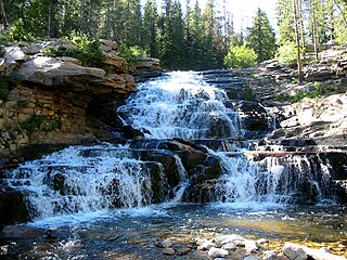
The Provo River is located in Utah County and Wasatch County, Utah, in the United States. It rises in the Uinta Mountains at Wall Lake and flows about 71 miles (114 km) southwest to Utah Lake at the city of Provo, Utah.

<span class="mw-page-title-main">Black Hawk War (1865–1872)</span> Part of the Ute, Apache, and Navajo Wars

The Black Hawk War, or Black Hawk's War, is the name of the estimated 150 battles, skirmishes, raids, and military engagements taking place from 1865 to 1872, primarily between Mormon settlers in Sanpete County, Sevier County and other parts of central and southern Utah, and members of 16 Ute, Southern Paiute, Apache and Navajo tribes, led by a local Ute war chief, Antonga Black Hawk. The conflict resulted in the abandonment of some settlements and hindered Mormon expansion in the region.

<span class="mw-page-title-main">Rock Canyon (Provo, Utah)</span> Mountain in the American state of Utah

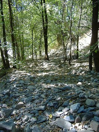
Rock Canyon is located in the Wasatch Mountains, in east Provo, Utah, United States. It is popular with rock climbers and hikers due to its unique and rugged geology as well as its proximity to Brigham Young University. The mouth of the canyon is located just behind the Provo Utah Temple.

<span class="mw-page-title-main">Provo Canyon</span> In Utah County and Wasatch County, Utah

Provo Canyon is located in unincorporated Utah County and Wasatch County, Utah. Provo Canyon runs between Mount Timpanogos on the north and Mount Cascade on the south. The canyon extends from Orem on the west end to Heber City on the east. Provo Canyon is situated to the east of Utah Valley and grants access to the valleys and Uinta Basin regions that lie beyond the Wasatch front.

<span class="mw-page-title-main">Battle Creek massacre</span> 1849 massacre of Timpanogo Indians in Utah

The Battle Creek massacre was a lynching of a Timpanogos group on March 5, 1849, by a group of 35 Mormon settlers at Battle Creek Canyon near present-day Pleasant Grove, Utah. It was the first violent engagement between the settlers who had begun coming to the area two years before, and was in response to reported cattle theft by the group. The attacked group was outnumbered, outgunned, and had little defense against the militia that crept in and surrounded their camp before dawn. The massacre had been ordered by Brigham Young, the Utah territory governor and president of the Church of Jesus Christ of Latter-day Saints (LDS). The formation of the Mormon settlement of Utah Valley soon followed the attack at Battle Creek. One of the young survivors from the group of 17 children, women, and men who had been attacked grew up to be Antonga Black Hawk, a Timpanogos leader in the Black Hawk War.

<span class="mw-page-title-main">Trail of the Ancients</span> National Scenic Byways in Arizona, Colorado, New Mexico, and Utah, United States

The Trail of the Ancients is a collection of National Scenic Byways located in the U.S. Four Corners states of Utah, Colorado, New Mexico, and Arizona. These byways comprise:

The Battle at Fort Utah was a violent attack in 1850 in which 90 Mormon militiamen surrounded an encampment of Timpanogos families on the Provo River one winter morning, and laid siege for two days, eventually shooting between 40 and 100 Native American men and one woman with guns and a cannon during the attack as well as during the pursuit and capture of the two groups that fled the last night. One militiaman died from return fire during the siege. Of the Timpanogos people who fled in the night, one group escaped southward, and the other ran east to Rock Canyon. Both groups were captured, however, and the men were executed. Over 40 Timpanogos children, women, and a few men were taken as prisoners to nearby Fort Utah. They were later taken northward to the Salt Lake Valley and sold as slaves to church members there. The bodies of up to 50 Timpanogos men were beheaded by some of the settlers and their heads put on display at the fort as a warning to the mostly women and children prisoners inside.

Cherry Peak is a ski area in northern Utah that opened in 2014 and first used for skiing in the 2015–2016 season. It is located in Cherry Canyon, east of Richmond, Utah in the Bear River Mountains. While smaller and less developed than a number of Utah ski resorts, Cherry Peak is close and convenient to residents of nearby Logan, Utah State University, and Cache Valley. It also hosts students from more distant universities.

References

  1. 1 2 3 4 5 Udall, Rulon. "The Naming of a Peak". Intermountain Histories. BYU . Retrieved November 21, 2022.
  2. 1 2 3 Gunderson, Abigail (September 14, 2022). "Squaw Peak name change highlights sexual violence against Native American women". The Daily Universe . Retrieved November 21, 2022.
  3. 1 2 "Squaw Peak Hike « Rock Canyon Provo, Utah". www.rockcanyonutah.com. Retrieved November 21, 2022.
  4. 1 2 "Geographic Names Information System". edits.nationalmap.gov. US Government. Retrieved November 21, 2022.
  5. Colton, Ray (January 1, 1946). "A Historical Study of the Exploration of Utah Valley and the Story of Fort Utah". Theses and Dissertations. BYU.
  6. Utah State Office of Education (1992). "Indian Place Names" (PDF).
  7. 1 2 3 "Provo's Squaw Peak renamed to Kyhv Peak". Daily Herald . Retrieved November 21, 2022.
  8. 1 2 3 Duncan, Clifford (2000). "The Northern Utes of Utah". The History of Utah's American Indians. Colorado: University Press of Colorado. pp. 1–60. doi:10.2307/j.ctt46nwms.8. ISBN   9780913738481. JSTOR   j.ctt46nwms.8.
  9. O'Neill, Floyd Alexander (1973). A History of the Ute Indians Of Utah Until 1890 (PhD thesis). University of Utah. ProQuest   302699920 via ProQuest.
  10. 1 2 "Utah group looks to rename Squaw Peak, says term belittles Native American women". Deseret News . LDS Church. November 10, 2017. Retrieved November 21, 2022.
  11. 1 2 3 Park, McKenna (April 27, 2017). "Native Americans advocate Squaw Peak name change". The Daily Universe . BYU . Retrieved November 21, 2022.
  12. 1 2 "Committee supports effort to make it easier to drop derogatory Native American names from Utah places". The Salt Lake Tribune . Retrieved November 21, 2022.
  13. 1 2 Cleary, Kaela (November 16, 2020). "Proposed bill would rename Squaw Peak". The Daily Universe . BYU . Retrieved November 21, 2022.
  14. Nick, I. M. (2017). "Squaw Teats*, Harney Peak, and Negrohead Creek*: A Corpus-Linguistic Investigation of Proposals to Change Official US Toponymy to (Dis)honor Indigenous US Americans". Names: A Journal of Onomastics . 65 (4). American Name Society: 223–234. doi:10.1080/00277738.2017.1370067. S2CID   134789587.
  15. "Place Name Amendments" (PDF). Utah State Government. 2021.
  16. "New poll finds 9 in 10 Native Americans aren't offended by Redskins name". Washington Post . May 19, 2016. Archived from the original on May 19, 2016 via Internet Archive.

Commons-logo.svg Media related to Kyhv Peak at Wikimedia Commons