Firth is a word in the English and Scots languages used to denote various coastal waters in the United Kingdom, predominantly within Scotland. In the Northern Isles, it more often refers to a smaller inlet. It is linguistically cognate to fjord, which has a more constrained sense in English. Bodies of water named "firths" tend to be more common on the Scottish east coast, or in the southwest of the country, although the Firth of Clyde is an exception to this. The Highland coast contains numerous estuaries, straits, and inlets of a similar kind, but not called "firth" ; instead, these are often called sea lochs. Before about 1850, the spelling "Frith" was more common.
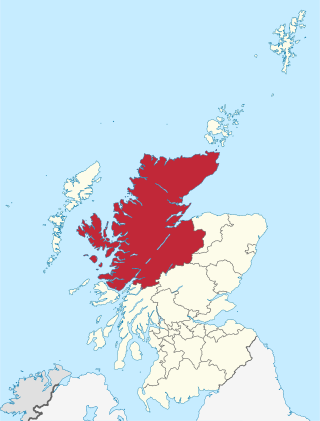
Highland is a council area in the Scottish Highlands and is the largest local government area in the United Kingdom. It was the 7th most populous council area in Scotland at the 2011 census. It shares borders with the council areas of Aberdeenshire, Argyll and Bute, Moray and Perth and Kinross. Their councils, and those of Angus and Stirling, also have areas of the Scottish Highlands within their administrative boundaries.
A causeway is a track, road or railway on the upper point of an embankment across "a low, or wet place, or piece of water". It can be constructed of earth, masonry, wood, or concrete. One of the earliest known wooden causeways is the Sweet Track in the Somerset Levels, England, which dates from the Neolithic age. Timber causeways may also be described as both boardwalks and bridges.
Sutherland is a historic county, registration county and lieutenancy area in the Highlands of Scotland. Its county town is Dornoch. Sutherland borders Caithness and Moray Firth to the east, Ross-shire and Cromartyshire to the south and the Atlantic to the north and west. Like its southern neighbour Ross-shire, Sutherland has some of the most dramatic scenery in Europe, especially on its western fringe where the mountains meet the sea. These include high sea cliffs, and very old mountains composed of Precambrian and Cambrian rocks.

Ross and Cromarty, also referred to as Ross-shire and Cromartyshire, is a variously defined area in the Highlands and Islands of Scotland. There is a registration county and a lieutenancy area in current use, the latter of which is 8,019 square kilometres in extent. Historically there has also been a constituency of the Parliament of the United Kingdom, a local government county, a district of the Highland local government region and a management area of the Highland Council. The local government county is now divided between two local government areas: the Highland area and Na h-Eileanan Siar. Ross and Cromarty border Sutherland to the north and Inverness-shire to the south.

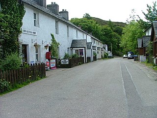
Tongue is a coastal village in northwest Highland, Scotland, in the western part of the former county of Sutherland. It lies on the east shore above the base of the Kyle of Tongue and north of the mountains Ben Hope and Ben Loyal on the A836. To the north lies the area of Braetongue.

The A87 is a major road in the Highland region of Scotland.

The Skye Bridge is a road bridge over Loch Alsh, Scotland, connecting the Isle of Skye to the island of Eilean Bàn. The name is also used for the whole Skye Crossing, which further connects Eilean Bàn to the mainland across the Carrich Viaduct. The crossing forms part of the A87.

The Kyles of Bute form a narrow sea channel that separates the northern end of the Isle of Bute from the Cowal peninsula in Argyll and Bute, on the Scottish mainland. The surrounding hillsides are roughly wooded, and overlooked by rocky tops and areas of moorland.
Glenelg (Scottish Gaelic: Glinn Eilg, also Gleann Eilg is a scattered community area and civil parish in the Lochalsh area of Highland in western Scotland. Despite the local government reorganisation the area is considered by many still to be in Inverness-shire, the boundary with Ross-shire being at the top of Mam Ratagan the single-track road entry into Glenelg.

Dornie is a small former fishing village in the Lochalsh district in western Ross-shire Highlands of Scotland. It is near the meeting point of Loch Duich, Loch Alsh and Loch Long.

Bonar Bridge is a village on the north bank of the Kyle of Sutherland to the west and the Dornoch Firth to the east in the Parish of Creich in the Highland council area of Scotland.
The A838 is a major road in Sutherland, in the Highland area of Scotland. It runs generally northwest from the A836 in the Lairg area to Laxford Bridge on the west coast of Scotland, then generally northeast to Durness on the north coast, and then generally east/southeast to Tongue, where it rejoins the A836. The A836 takes a more direct route from Lairg to Tongue.

The River Shin is a river in the Scottish North West Highlands.
Kirkcowan is an area about 15 miles in length, and from nearly two to nearly seven miles in breadth, comprising 30,580 acres, of which 7000 are arable, 300 woodland and plantations, and the remainder meadow, pasture in Machars, in the historical county of Wigtownshire, in Dumfries and Galloway, Scotland, with the village of Kirkcowan, bounded on the east by the river Bladnoch, on the west by the river Tarff, and is 6 miles W. by S.W. from Newton Stewart.

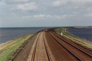
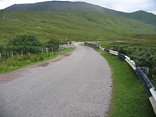
The Kyle of Tongue is a shallow sea loch in northwest Highland, Scotland, in the western part of Sutherland. Featuring a rocky coastline, its mouth is formed at Tongue Bay. The community of Tongue is situated on the Kyle's eastern shore and the loch is crossed by the Kyle of Tongue Bridge and Causeway.
Events from the year 1971 in Scotland.
Loch Bì, sometimes anglicised as Loch Bee, is the largest loch on the island of South Uist in the Outer Hebrides of Scotland. It lies at the northern end of the island


