
Traffic engineering is a branch of civil engineering that uses engineering techniques to achieve the safe and efficient movement of people and goods on roadways. It focuses mainly on research for safe and efficient traffic flow, such as road geometry, sidewalks and crosswalks, cycling infrastructure, traffic signs, road surface markings and traffic lights. Traffic engineering deals with the functional part of transportation system, except the infrastructures provided.

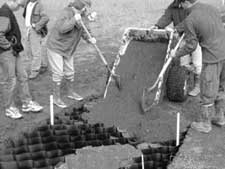
A road surface or pavement is the durable surface material laid down on an area intended to sustain vehicular or foot traffic, such as a road or walkway. In the past, gravel road surfaces, macadam, hoggin, cobblestone and granite setts were extensively used, but these have mostly been replaced by asphalt or concrete laid on a compacted base course. Asphalt mixtures have been used in pavement construction since the beginning of the 20th century and are of two types: metalled (hard-surfaced) and unmetalled roads. Metalled roadways are made to sustain vehicular load and so are usually made on frequently used roads. Unmetalled roads, also known as gravel roads or dirt roads, are rough and can sustain less weight. Road surfaces are frequently marked to guide traffic.

Asphalt concrete is a composite material commonly used to surface roads, parking lots, airports, and the core of embankment dams. Asphalt mixtures have been used in pavement construction since the beginning of the twentieth century. It consists of mineral aggregate bound together with bitumen, laid in layers, and compacted.
A dipstick is one of several measurement devices.

The American Society of Civil Engineers (ASCE) is a tax-exempt professional body founded in 1852 to represent members of the civil engineering profession worldwide. Headquartered in Reston, Virginia, it is the oldest national engineering society in the United States. Its constitution was based on the older Boston Society of Civil Engineers from 1848.
The frost line—also known as frost depth or freezing depth—is most commonly the depth to which the groundwater in soil is expected to freeze. The frost depth depends on the climatic conditions of an area, the heat transfer properties of the soil and adjacent materials, and on nearby heat sources. For example, snow cover and asphalt insulate the ground and homes can heat the ground. The line varies by latitude, it is deeper closer to the poles. The maximum frost depth observed in the contiguous United States ranges from 0 to 8 feet (2.4 m). Below that depth, the temperature varies, but is always above 32 °F (0 °C).

The Federal Highway Administration (FHWA) is a division of the United States Department of Transportation that specializes in highway transportation. The agency's major activities are grouped into two programs, the Federal-aid Highway Program and the Federal Lands Highway Program. Its role had previously been performed by the Office of Road Inquiry, Office of Public Roads and the Bureau of Public Roads.
Weigh-in-motion or weighing-in-motion (WIM) devices are designed to capture and record the axle weights and gross vehicle weights as vehicles drive over a measurement site. Unlike static scales, WIM systems are capable of measuring vehicles traveling at a reduced or normal traffic speed and do not require the vehicle to come to a stop. This makes the weighing process more efficient, and, in the case of commercial vehicles, allows for trucks under the weight limit to bypass static scales or inspection.
The National Bridge Inventory (NBI) is a database, compiled by the Federal Highway Administration, with information on all bridges and tunnels in the United States that have roads passing above or below them. That is similar to the grade-crossing identifier number database, compiled by the Federal Railroad Administration, which identifies all railroad crossings. The bridge information includes the design of the bridge and the dimensions of the usable portion. The data is often used to analyze bridges and to judge their condition. The inventory is developed for the purpose of having a unified database for bridges to ensure the safety of the traveling public, as required by the Federal Aid Highway Act of 1968. It includes identification information, bridge types and specifications, operational conditions, bridge data including geometric data and functional description, and inspection data. Any bridge more than 20 ft long used for vehicular traffic is included.
The pavement condition index (PCI) is a numerical index between 0 and 100, which is used to indicate the general condition of a pavement section. The PCI is widely used in transportation civil engineering and asset management, and many municipalities use it to measure the performance of their road infrastructure and their levels of service. It is a statistical measure and requires manual survey of the pavement. This index was originally developed by the United States Army Corps of Engineers as an airfield pavement rating system, but later modified for roadway pavements and standardized by the ASTM. The surveying processes and calculation methods have been documented and standardized by ASTM for both roads and airport pavements:
Pavement management is the process of planning the maintenance and repair of a network of roadways or other paved facilities in order to optimize pavement conditions over the entire network.
Road surface textures are deviations from a planar and smooth surface, affecting the vehicle/tyre interaction. Pavement texture is divided into: microtexture with wavelengths from 0 mm to 0.5 millimetres (0.020 in), macrotexture with wavelengths from 0.5 millimetres (0.020 in) to 50 millimetres (2.0 in) and megatexture with wavelengths from 50 millimetres (2.0 in) to 500 millimetres (20 in).
Cellular confinement systems (CCS)—also known as geocells—are widely used in construction for erosion control, soil stabilization on flat ground and steep slopes, channel protection, and structural reinforcement for load support and earth retention. Typical cellular confinement systems are geosynthetics made with ultrasonically welded high-density polyethylene (HDPE) strips or novel polymeric alloy (NPA)—and expanded on-site to form a honeycomb-like structure—and filled with sand, soil, rock, gravel or concrete.

The international roughness index (IRI) is the roughness index most commonly obtained from measured longitudinal road profiles. It is calculated using a quarter-car vehicle math model, whose response is accumulated to yield a roughness index with units of slope. Although a universal term, IRI is calculated per wheelpath, but can be expanded to a Mean Roughness Index (MRI) when both wheelpath profiles are collected. This performance measure has less stochasticity and subjectivity in comparison to other pavement performance indicators, such as PCI, but it is not completely devoid of randomness. The sources of variability in IRI data include the difference among the readings of different runs of the test vehicle and the difference between the readings of the right and left wheel paths. Despite these facts, since its introduction in 1986, the IRI has become the road roughness index most commonly used worldwide for evaluating and managing road systems.

Competitive programming or sport programming is a mind sport involving participants trying to program according to provided specifications. The contests are usually held over the Internet or a local network. Contestants are referred to as sport programmers. Competitive programming is recognized and supported by several multinational software and Internet companies, such as Google and Meta.

Long-Term Pavement Performance Program, known as LTPP, is a research project supported by Federal Highway Administration (FHWA) to collect and analyze pavement data in the United States and Canada. Currently, the LTPP acquires the largest road performance database.

Pavement performance modeling or pavement deterioration modeling is the study of pavement deterioration throughout its life-cycle. The health of pavement is assessed using different performance indicators. Some of the most well-known performance indicators are Pavement Condition Index (PCI), International Roughness Index (IRI) and Present Serviceability Index (PSI), but sometimes a single distress such as rutting or the extent of crack is used. Among the most frequently used methods for pavement performance modeling are mechanistic models, mechanistic-empirical models, survival curves and Markov models. Recently, machine learning algorithms have been used for this purpose as well. Most studies on pavement performance modeling are based on IRI.

Kumares C. Sinha is an Indian-American engineer, researcher and educator known for contributions to transportation systems analysis, transportation infrastructure economics and management, transportation safety, and the use of emerging technologies in transportation. He has served as Edgar B. and Hedwig M. Olson Distinguished Professor of Civil Engineering at Purdue University. since 1998.
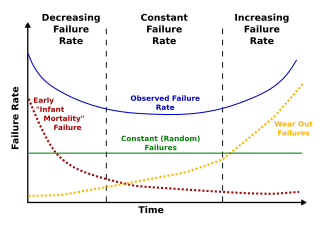
Deterioration modeling is the process of modeling and predicting the physical conditions of equipment, structures, infrastructure or any other physical assets. The condition of infrastructure is represented either using a deterministic index or the probability of failure. Examples of such performance measures are pavement condition index for roads or bridge condition index for bridges. For probabilistic measures, which are the focus of reliability theory, probability of failure or reliability index are used. Deterioration models are instrumental to infrastructure asset management and are the basis for maintenance and rehabilitation decision-making. The condition of all physical infrastructure degrade over time. A deterioration model can help decision-makers to understand how fast the condition drops or violates a certain threshold.
Levels of service (LOS) is a term in asset management referring to the quality of a given service. Defining and measuring levels of service is a key activity in developing infrastructure asset management plans. Levels of service may be tied to physical performance of assets or be defined via customer expectation and satisfaction. The latter is more service-centric rather than asset-centric. For instance, when measuring the LOS of a road, it could be measured by a physical performance indicator such as Pavement Condition Index (PCI) or by a measure related to customer satisfaction such as the number of complaints per month about that certain road section. Or in the case of traffic level of service, it could be measured by the geometry of road or by travel time of the vehicles, which reflects the quality of traffic flow. So, levels of service can have multiple facets: customer satisfaction, environmental requirements and legal requirements.