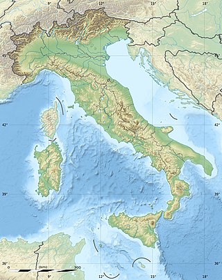
The geography of Italy includes the description of all the physical geographical elements of Italy. Italy, whose territory largely coincides with the homonymous geographical region, is located in southern Europe and comprises the long, boot-shaped Italian Peninsula crossed by the Apennines, the southern side of Alps, the large plain of the Po Valley and some islands including Sicily and Sardinia. Italy is part of the Northern Hemisphere. Two of the Pelagie Islands are located on the African continent.

The Rhine is one of the major European rivers. The river begins in the Swiss canton of Graubünden in the southeastern Swiss Alps. It forms part of the Swiss-Liechtenstein, Swiss-Austrian, and Swiss-German borders. After that the Rhine defines much of the Franco-German border, after which it flows in a mostly northerly direction through the German Rhineland. Finally in Germany, the Rhine turns into a predominantly westerly direction and flows into the Netherlands where it eventually empties into the North Sea. It drains an area of 9,973 sq km and its name derives from the Celtic Rēnos. There are also two German states named after the river, North Rhine-Westphalia and Rhineland-Palatinate.

The river Ticino is the most important perennial left-bank tributary of the Po. It has given its name to the Swiss canton through which its upper portion flows.

The Inn is a river in Switzerland, Austria and Germany. The river is 518 km (322 mi) long. It is a right tributary of the Danube and it is the third largest tributary of the Danube by discharge. The highest point of its drainage basin is the summit of Piz Bernina at 4,049 m (13,284 ft). The Engadine, the valley of the En, is the only Swiss valley whose waters end up in the Black Sea.

An endorheic basin is a drainage basin that normally retains water and allows no outflow to other, external bodies of water ; instead, the water drainage flows into permanent and seasonal lakes and swamps that equilibrate through evaporation. Endorheic basins also are called closed basins, terminal basins, and internal drainage systems.

The Province of Brescia is a Province in the Lombardy administrative region of northern Italy. It has a population of some 1,265,964 and its capital is the city of Brescia.

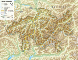
The Vorderrhein is one of the two sources of the Rhine. Its catchment area of 1,512 square kilometres is located predominantly in the canton of Graubünden (Switzerland). The Vorderrhein is about 76 kilometres (47 mi) long, thus more than 5% longer than the Hinterrhein/Rein Posteriur. The Vorderrhein, however, has an average water flow of 53.8 m3/s (1,900 cu ft/s), which is less than the flow of the Hinterrhein. According to the Atlas of Switzerland of the Swiss Federal Office of Topography, the source of the Vorderrhein—and thus of the Rhine—is located north of the Rein da Tuma and Lake Toma.

Innerferrera is a village in the district of Hinterrhein in the Swiss canton of Graubünden. Previously an independent municipality, it merged on January 1, 2008 with neighboring Ausserferrera to form the municipality of Ferrera.

Lake Qaraoun is an artificial lake or reservoir located in the southern region of the Beqaa Valley, Lebanon. It was created near Qaraoun village in 1959 by building a 61 m-high (200 ft) concrete-faced rockfill dam in the middle reaches of the Litani River. The reservoir has been used for hydropower generation, domestic water supply, and for irrigation of 27,500 ha.

The Geography of Piedmont is that of a territory predominantly mountainous, 43.3%, but with extensive areas of hills which represent 30.3% of the territory, and of plains (26.4%).

The Chiese, also known in the Province of Brescia as the Clisi, is a 160-kilometre (99 mi) Italian river that is the principal immisary and sole emissary of the sub-alpine lake Lago d’Idro, and is a left tributary of the Oglio.
The Hinterrhein is one of the two initial tributaries of the Rhine rising in the canton of Graubünden in Switzerland.

The Melezza, in Italy the Melezzo Orientale, is a 42 km Alpine torrent which runs through the eastern part of the Val Vigezzo, in the Province of Verbano Cusio Ossola, northern Italy; and through the Centovalli of Canton Ticino, Switzerland. Belonging to the Po basin, it is a tributary of the Maggia which in its turn flows into Lago Maggiore.
Lake Toma in the Swiss canton of Graubünden is generally regarded as the Source of the Rhine. Its outflow is called Rein da Tuma and after a few kilometers, it forms the Vorderrhein/Rein Anteriur. The course of this river is not particularly representative: after about two kilometers, its water is diverted into Curnera reservoir. The water is released at the Tavanase plant and flows into the Rhine at Ilanz. The river begins to be called Rhine in the vicinity of Chur, more specifically, at the confluence of the Vorderrhein and Hinterrhein/Rein Posteriur next to Reichenau in Tamins.

The Rein da Medel is the longest headwater of the Rhine. It is located in the Swiss cantons of Ticino and Graubünden and flows through the valleys Val Cadlimo and Val Medel. Rein da Medel is the local Sursilvan, name in Graubünden, which is commonly used to denote the ticinese part as well.
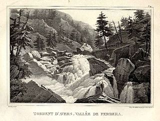
The Avers Rhine is a tributary of the Hinterrhein/Rein Posteriur in the Swiss canton of Graubünden.

The Linth–Limmern Power Stations are a system of hydroelectric power stations located south of Linthal in the canton of Glarus, Switzerland. The system uses five reservoirs and four power stations at steep variations in altitude.

The border between the modern states of Switzerland and Italy extends for 744 kilometres (462 mi), from the French-Swiss-Italian tripoint at Mont Dolent in the west to the Austrian-Swiss-Italian tripoint near Piz Lad in the east. Much of the border runs across the High Alps, rising above 4,600 metres (15,100 ft) as it passes east of Dufourspitze, but it also descends to the lowest point in Switzerland as it passes Lago Maggiore at below 200 metres (660 ft).