The Metropolitan Water District of Southern California is a regional wholesaler and the largest supplier of treated water in the United States. The name is usually shortened to "Met," "Metropolitan," or "MWD." It is a cooperative of fourteen cities, eleven municipal water districts, and one county water authority, that provides water to 19 million people in a 5,200-square-mile (13,000 km2) service area. It was created by an act of the California State Legislature in 1928, primarily to build and operate the Colorado River Aqueduct. Metropolitan became the first contractor to the State Water Project in 1960.

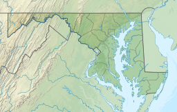
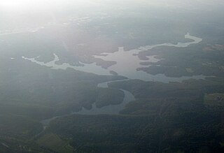
Prettyboy Reservoir is a 1,500-acre (610 ha) reservoir in the Hereford Zone of northern Baltimore County, Maryland. While the reservoir is in Baltimore County, the independent city of Baltimore owns the reservoir and the surrounding land. The reservoir is one of three reservoirs created to supply the municipal water system for Baltimore City, Baltimore County, and northern Anne Arundel County constructed by the Baltimore City Department of Public Works. Prettyboy Reservoir, along with Loch Raven Reservoir further down the Big Gunpowder Falls, provide about 61% of the drinking water for the Baltimore metropolitan area system; for this reason, the Prettyboy is considered a "source water" or drinking water watershed. The reservoir contains about 19 billion US gallons (72,000,000 m3) of water on average.

A combination of aqueducts, reservoirs, and tunnels supplies fresh water to New York City. With three major water systems stretching up to 125 miles (201 km) away from the city, its water supply system is one of the most extensive municipal water systems in the world.

The McMillan Reservoir is a reservoir in Washington, D.C., that supplies the majority of the city's municipal water. It was originally called the Howard University Reservoir or the Washington City Reservoir, and was completed in 1902 by the U.S. Army Corps of Engineers.

Maryland Route 41 is a state highway in the U.S. state of Maryland. Known for most of its length as Perring Parkway, the state highway runs 6.75 miles (10.86 km) from MD 147 in Baltimore north to Waltham Woods Road in Carney. MD 41 is a four- to six-lane divided highway that connects portions of Northeast Baltimore, including Morgan State University, with Parkville and Interstate 695 (I-695). The state highway is maintained by the Maryland State Highway Administration in Baltimore County and the Baltimore City Department of Transportation in the city, where it is unsigned. MD 41 was built in the early to mid-1960s, largely to relieve congestion on portions of neighboring Old Harford and Harford Roads during the period of rapid post-World War II growth in the area.

Horace Abbott was an American iron manufacturer and banker. His work included the armor plating for the USS Monitor, USS Agamenticus, USS Roanoke, and USS Monadnock.

Cooper Lake, located near Lake Hill in the Town of Woodstock, Ulster County, New York, is the largest natural lake in the Catskill Mountains. However, it has been expanded somewhat over the years since it serves as the main reservoir for the nearby City of Kingston and Town of Ulster, which stores water there that it pipes from Mink Hollow Stream in addition to the water that reaches the lake from its 8.6-square mile (22.4 km²) drainage basin.

Doris M. Johnson High School was a public high school located in the northeast area known as Clifton Park of Baltimore, Maryland.

The Baltimore Public Works Museum was located at 751 Eastern Avenue, Pier 7 of the Inner Harbor, Baltimore, Maryland. This museum provided a behind-the-scenes glimpse of how a large city provides public works utility services to its citizens. Exhibits also explained street lighting, road maintenance, and trash removal. An outdoor sculpture called Streetscape was an intricate model of a network of phone lines, street lights, storm drains and pipes for water, gas, and sewage disposal. The building housing this display is an operating sewage pumping station built in 1912.
The Erie Water Works was incorporated in 1865 as the Erie Water and Gas Company to provide drinking water and fire hydrant water for the city of Erie, Pennsylvania. The Water Works, also known as the Erie City Water Authority, replaced the Erie Water Systems. Its board of commissioners operates independently of the city government.

The Coldstream-Homestead-Montebello community, often abbreviated to C-H-M, is a neighborhood in northeastern Baltimore, Maryland. A portion of the neighborhood has been listed on the National Register of Historic Places as the Coldstream Homestead Montebello Historic District, recognized for the development of a more suburban style of rowhouses.

Clifton Park is a public urban park and national historic district located between the Coldstream-Homestead-Montebello and Waverly neighborhoods to the west and the Belair-Edison, Lauraville, Hamilton communities to the north in the northeast section of Baltimore, Maryland, United States. It is roughly bordered by Erdman Avenue to the northeast, Sinclair Lane to the south, Harford Road to the northwest and Belair Road to the southeast. The eighteen-hole Clifton Park Golf Course, which is the site of the annual Clifton Park Golf Tournament, occupies the north side of the park.
The Loch Raven Reservoir is a reservoir that provides drinking water for the City of Baltimore and most of Baltimore County, Maryland. It is fed by the Big Gunpowder Falls river, and has a capacity of 23 billion US gallons (87,000,000 m3) of water.

Lake Roland is a 100-acre (0.40 km2) defunct reservoir in Baltimore County, Maryland. It was named for Roland Run, a nearby stream that feeds the lake and eventually flows into Jones Falls. It runs southeast through the city center to the Northwest Branch of the Patapsco River and the Baltimore Harbor. It is located just north of the Baltimore city limits.

The Jones Falls is a 17.9-mile-long (28.8 km) stream in Maryland. It is impounded to create Lake Roland before running through the city of Baltimore and finally emptying into the Baltimore Inner Harbor.

Mayfield is a quaint and historic community in northeast Baltimore, Maryland. It is bounded by Erdman Avenue on the south, Chesterfield Avenue on the north, Crossland Avenue on the east and Lake Montebello on the north and west. Homeowners belong to the Mayfield Improvement Association.
33rd Street, originally called Thirty-third Street Boulevard, is a long, wide, east–west parkway with a broad tree-shaded median strip. It is surrounded by 1920s-era "Daylight-styled" row houses with porches and small front yards. It was designed by the Frederick Law Olmsted Brothers firm, as part of their Baltimore Plan of 1904 and 1921 for establishing stream valley parks and connecting boulevards.
Hanlon Longwood is a neighborhood in the Northwest District of Baltimore, located between the neighborhoods of Garwyn Oaks (west) and Burleigh–Leighton (east). It is bounded by North Dukeland Street (east), Garrison Boulevard (west) and the Gwynns Falls Parkway (south). The neighborhood's north boundary is marked by North Longwood Street, North Hilton Street and Liberty Heights Avenue.
John Robert Baylis was an American chemist and sanitary engineer. His career extended from about 1905 to 1963 and he is best known for his work in applied research to improve drinking water purification.