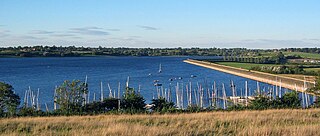
Draycote Water is a 240-hectare (590-acre) reservoir and country park near the village of Dunchurch, 3.75 miles (6 km) south of Rugby in Warwickshire, England, owned and operated by Severn Trent Water. It draws its water from the River Leam, and supplies drinking water to Rugby and Coventry. It is named after the nearby hamlet of Draycote.

The Lake of the Arbuckles is a reservoir located in southern Oklahoma, 8 miles (13 km) southwest of Sulphur in Murray County. The lake covers 2,350 acres (950 ha) and is a principal water supply reservoir for the city of Ardmore, some 30 mi (48 km) to the southwest. It also supplies water to the cities of Sulphur, Davis, Wynnewood and a large oil refinery near Wynnewood. The lake also provides flood control, fish and wildlife habitat and recreation opportunities.
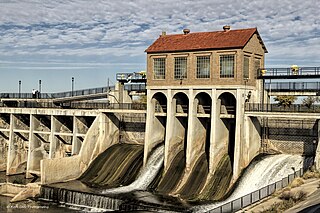
Lake Overholser is a reservoir within the city limits of Oklahoma City, Oklahoma. Lake Overholser is formed by Overholser Dam on the North Canadian River in Oklahoma County, Oklahoma. The lake is 2.9 miles (4.7 km) west of Bethany and 4.4 mi (7.1 km) from Yukon. Lake Overholser is named after Ed Overholser who was the 16th Mayor of the City of Oklahoma City.
Konawa Reservoir is a reservoir located in Seminole County, Oklahoma. The lake covers approximately 1,350 acres (5.5 km2) and has a capacity of 23,000 acre-feet (28,000,000 m3). It is owned by Oklahoma Gas and Electric (OG&E) Company. and was constructed in 1968-70, to provide cooling for a nearby gas-fired electric power generation plant. It impounds Jumper Creek, about 2 miles (3.2 km) east of the city of Konawa, Oklahoma.
McGee Creek Reservoir is a reservoir in Atoka County, Oklahoma. It impounds the waters of McGee Creek and several smaller streams, including Potapo, Panther, Little Bugaboo, Bear, Blue, Mill, and Crooked creeks, all of which are tributaries of Muddy Boggy River. According to the Bureau of Reclamation (BuRec), the reservoir was designed to extend 14 miles (23 km) up McGee Creek and 9 miles (14 km) up Potapo Creek when the water is at "conservation level.
Lake Thunderbird is a reservoir located in Norman, Oklahoma. The lake was constructed between 1962 and 1965 for the purpose of providing municipal water to the nearby communities of Del City, Midwest City and Norman. It is formed by an earthfill embankment (dam) 7,300 feet (2,200 m) long and up to 144 feet (44 m) high on the Little River. In addition to being a source for drinking water, Lake Thunderbird's secondary uses include numerous recreational activities.
Stockton Lake is a reservoir located in southeastern Cedar County, northeastern Dade County, and southwestern Polk County, Missouri. The lake is 'V' shaped, and covers 39 square miles (100 km2), with 298 miles (480 km) of shoreline. It has three marinas, and 10 public-use areas. It has a "non-development policy," and is surrounded by unspoiled, tree-covered hills. Its banks are owned and operated by the Army Corps of Engineers.

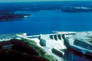
Canyon Lake is a reservoir on the Guadalupe River in the Texas Hill Country in the United States. Canyon Lake is a U.S. Army Corps of Engineers reservoir formed on the Guadalupe River in Comal County by Canyon Dam, which is located about sixteen miles northwest of New Braunfels. The dam, lake, and all adjacent property are managed by the U.S. Army Corps Of Engineers. Water rights, waste water treatment, and hydroelectric generating facilities are managed by the Guadalupe-Blanco River Authority. Construction of the dam began in 1958 and was completed in 1964. The reservoir serves to provide flood control and water supply for the communities downstream from the dam. The lake is also a popular recreational destination.

Lake Altus-Lugert, also known as Lake Altus, Lake Lugert, Lake Lugert-Altus, and Lugert Lake, is a reservoir located on the North Fork Red River, about 17 miles (27 km) north of Altus, Oklahoma on the former site of the town of Lugert, Oklahoma. The river is the boundary between Greer County and Kiowa County, Oklahoma. The lake is used for fishing, boating, swimming, and irrigation. This is also the principal water supply for Altus.
Lake Ellsworth is a lake in Caddo and Comanche counties in the state of Oklahoma in the United States. It was built by the City of Lawton, Oklahoma in 1962, primarily to serve as a water supply source for Lawton and the surrounding area. The nearest community is Elgin, Oklahoma.
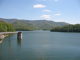
Watauga Lake, located east of Elizabethton, Tennessee, is the local name of the Watauga Reservoir created by the Tennessee Valley Authority (TVA) with the 1948 completion of the TVA Watauga Dam.
Lake Atoka Reservoir is a reservoir in southeastern Oklahoma, 4 miles (6.4 km) north of Atoka, Oklahoma, county seat of Atoka County, Oklahoma. It was built in 1959 to expand the water supply for Lake Stanley Draper in Oklahoma City and Atoka.

Optima Lake was built to be a reservoir in Texas County, Oklahoma. The site is just north of Hardesty and east of Guymon in the Oklahoma Panhandle.
The Central Utah Project is a US federal water project that was authorized for construction under the Colorado River Storage Project Act of April 11, 1956, as a participating project. In general, the Central Utah Project develops a portion of Utah's share of the yield of the Colorado River, as set out in the Colorado River Compact of 1922.

The Los Vaqueros Reservoir and watershed is located in the northern Diablo Range, within northeastern Contra Costa County, northern California. It was completed by the Contra Costa Water District (CCWD) in 1998 to improve the quality of drinking water for its 550,000 customers in Central and Eastern Contra Costa County. The reservoir is accessible via Vasco Road, a road which connects Brentwood and Livermore.
Dripping Springs Park is located in Okmulgee County, Oklahoma, near the city of Okmulgee, Oklahoma. Previously Dripping Springs State Park, the lake and park are now owned by Okmulgee, and are approximately 9 miles (14 km) south of the city.

Calero Reservoir, also called Calero Lake, is a reservoir in San Jose, California, located in the Calero neighborhood of Almaden Valley in South San Jose. It is the site of Calero County Park, which also includes a large area covering the lake and hundreds of acres of hills around it.

Lake Yahola is a reservoir in Tulsa, Oklahoma. The reservoir was completed in 1924. Its primary purpose is to store raw water for treatment and distribution. This city-owned, 2-billion-US-gallon (7,600,000 m3), concrete-lined lake is an integral part of the Tulsa water supply, and receives water by pipeline from Lake Spavinaw. It is located in Mohawk Park, adjacent to the Mohawk Water Treatment Plant.
Lake Bixhoma, is a public reservoir owned and operated by the city of Bixby, Oklahoma. Lake Bixhoma has 3 miles (4.8 km) of shoreline, a surface area of 110 acres (45 ha) and a maximum depth of 50 feet (15 m). It is located on Bixhoma Lake Road about 7 miles southeast of Bixby, and 2.2 miles south of U.S. 64 and the community of Leonard, Oklahoma. Built in 1965, it is situated on Leonard Mountain at an elevation of 899 feet (274 m) above sea level, nearly 300 feet (91 m) above the elevation of Bixby, and was originally built to supply raw water to the city.

