
A township is a kind of human settlement or administrative subdivision, with its meaning varying in different countries.

The Public Land Survey System (PLSS) is the surveying method developed and used in the United States to plat, or divide, real property for sale and settling. Also known as the Rectangular Survey System, it was created by the Land Ordinance of 1785 to survey land ceded to the United States by the Treaty of Paris in 1783, following the end of the American Revolution. Beginning with the Seven Ranges in present-day Ohio, the PLSS has been used as the primary survey method in the United States. Following the passage of the Northwest Ordinance in 1787, the Surveyor General of the Northwest Territory platted lands in the Northwest Territory. The Surveyor General was later merged with the General Land Office, which later became a part of the U.S. Bureau of Land Management (BLM). Today, the BLM controls the survey, sale, and settling of lands acquired by the United States.
The Dominion Land Survey is the method used to divide most of Western Canada into one-square-mile (2.6 km2) sections for agricultural and other purposes. It is based on the layout of the Public Land Survey System used in the United States, but has several differences. The DLS is the dominant survey method in the Prairie provinces, and it is also used in British Columbia along the Railway Belt, and in the Peace River Block in the northeast of the province.
The term township, in Canada, is generally the district or area associated with a town. The specific use of the term to describe political subdivisions has varied by country, usually to describe a local rural or semirural government within the country itself.
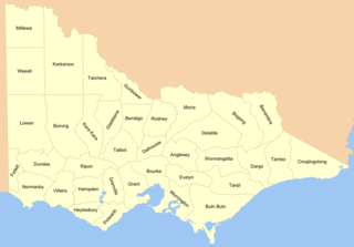
Cadastral divisions in Victoria are called counties, which are further subdivided into parishes and townships, for cadastral or land administration purposes. Cadastral divisions of county, parish and township form the basis for formal identification of the location of any piece of land in the state. There are 37 counties and 2004 parishes and 909 townships. Parishes were subdivided into sections of various sizes for sale as farming allotments, or designated as a town and then divided into sections and these subdivided into crown allotments. However, many parishes do not follow county borders, some being located in more than one county.

In the United States, a plat (plan) is a cadastral map, drawn to scale, showing the divisions of a piece of land. United States General Land Office surveyors drafted township plats of Public Lands Surveys to show the distance and bearing between section corners, sometimes including topographic or vegetation information. City, town or village plats show subdivisions broken into blocks with streets and alleys. Further refinement often splits blocks into individual lots, usually for the purpose of selling the described lots; this has become known as subdivision.
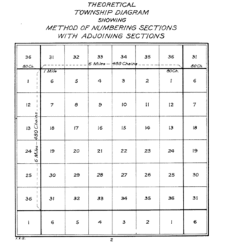
In U.S. land surveying under the Public Land Survey System (PLSS), a section is an area nominally one square mile, containing 640 acres, with 36 sections making up one survey township on a rectangular grid.

A cadastre or cadaster is a comprehensive recording of the real estate or real property's metes-and-bounds of a country. Often it is represented graphically in a cadastral map.
The lot and block survey system is a method used in the United States and in Canada to locate and identify land, particularly for lots in densely populated metropolitan areas, suburban areas and exurbs. It is sometimes referred to as the recorded plat survey system or the recorded map survey system.
A townsite is a legal subdivision of land for the development of a town or community. In the historical development of the United States, Canada, and other former British colonial nations, the filing of a townsite plat or plan (Canada) was often the first legal act in the establishment of a new town or community.

Lands administrative divisions of Australia are the cadastral divisions of Australia for the purposes of identification of land to ensure security of land ownership. Most states term these divisions as counties, parishes, hundreds, and other terms. The eastern states of Queensland, New South Wales, Victoria, and Tasmania were divided into counties and parishes in the 19th century, although the Tasmanian counties were renamed land districts in the 20th century. Parts of South Australia (south-east) and Western Australia (south-west) were similarly divided into counties, and there were also five counties in a small part of the Northern Territory. However South Australia has subdivisions of hundreds instead of parishes, along with the Northern Territory, which was part of South Australia when the hundreds were proclaimed. There were also formerly hundreds in Tasmania. There have been at least 600 counties, 544 hundreds and at least 15,692 parishes in Australia, but there are none of these units for most of the sparsely inhabited central and western parts of the country.
The lands administrative divisions of Western Australia refer to subdivisions of the state of Western Australia for cadastral purposes, most of which have been in place since the 19th century. The state is divided up for this purpose into five land divisions, which in turn are subdivided into land districts, which correspond to counties in other Australian states. These districts are then subdivided further into numbered locations, as well as gazetted townsites. Together, they form part of the lands administrative divisions of Australia.
Granville was the name from 1870 to 1886 for what would become the townsite of Vancouver, British Columbia. The townsite included the original settlement of Gastown.
The New Westminster Land District is one of 59 land districts of British Columbia, Canada, which are the underlying cadastral divisions of that province, created with rest of those on Mainland British Columbia via the Lands Act of the Colony of British Columbia in 1860. The British Columbia government's BC Names system, a subdivision of GeoBC, defines a land district as "a territorial division with legally defined boundaries for administrative purposes". All land titles and surveys use the Land District system as the primary point of reference, and entries in BC Names for placenames and geographical objects are so listed.
The Osoyoos Division Yale Land District is one of the 59 land districts of British Columbia, Canada, which are the underlying cadastral divisions of that province. All land titles and surveys use the Land District system as the primary point of reference, and entries in BC Names for placenames and geographical objects are so listed.
The Comox Land District is one of the 59 land districts of British Columbia, Canada, which are part of the cadastral divisions of British Columbia, created with rest of those on Vancouver Island via the Lands Act of the Colony of Vancouver Island. The British Columbia government's BC Names system, a subdivision of GeoBC, defines a land district as "a territorial division with legally defined boundaries for administrative purposes". All land titles and surveys use the Land District system as the primary point of reference, and entries in BC Names for placenames and geographical objects are so listed.
The Lillooet Land District is one of the 59 cadastral subdivisions of British Columbia, which were created by the Lands Act of the Colony of British Columbia in 1859, defined as "a territorial division with legally defined boundaries for administrative purposes". The land district's boundaries came to be used as the boundary of the initial Lillooet riding for the provincial Legislature from 1871, when the colony became a province. In addition to use in descriptions of land titles and lot surveys, the Land District was also the basis of the Lillooet Mining District.
Cadastral surveying is the sub-field of cadastre and surveying that specialises in the establishment and re-establishment of real property boundaries. It involves the physical delineation of property boundaries and determination of dimensions, areas and certain rights associated with properties. This is regardless of whether they are on land, water or defined by natural or artificial features. It is an important component of the legal creation of properties. A cadastral surveyor must apply both the spatial-measurement principles of general surveying and legal principles such as respect of neighboring titles.

In English common law, real property, real estate, immovable property or, solely in the US and Canada, realty, is land which is the property of some person and all structures integrated with or affixed to the land, including crops, buildings, machinery, wells, dams, ponds, mines, canals, roads, and other things. The term is historic, arising from the now-discontinued form of action, which distinguished between real property disputes and personal property disputes. Personal property, or personalty, was, and continues to be, all property that is not real property.
The Clayoquot Land District is one of the 59 land districts of British Columbia, Canada, which are part of the cadastral divisions of British Columbia, created with rest of those on Vancouver Island via the Lands Act of the Colony of Vancouver Island. The British Columbia government's BC Names system, a subdivision of GeoBC, defines a land district as "a territorial division with legally defined boundaries for administrative purposes". All land titles and surveys use the Land District system as the primary point of reference, and entries in BC Names for placenames and geographical objects are so listed.