Langford, British Columbia

Last updated

Langford
City of Langford
Looking East from Westhills to Rugby fields. SEE DESCRIPTION IN PANORAMIO - panoramio.jpg
Langford in 2012
Langford, BC flag.svg
24 Capital Regional District British Columbia.svg
Western Canada Map Assets City.svg
Langford
Location of Langford within the Capital Regional District
Canada Vancouver Island location map.svg
Red pog.svg
Langford
Location of Langford within British Columbia
Canada British Columbia location map 2.svg
Red pog.svg
Langford
Langford (British Columbia)
Coordinates: 48°27′2″N123°30′21″W / 48.45056°N 123.50583°W / 48.45056; -123.50583
CountryCanada
Province British Columbia
Regional district Capital
Founded1851
IncorporatedDecember 8, 1992
Government
  Governing bodyLangford City Council
  Mayor Scott Peter Goodmanson
  CouncillorsColby Harder, Mary Wagner, Keith Yacucha, Kimberley Guiry, Mark Morley, Lillian Szpak
Area
[1]
  Total41.43 km2 (16.00 sq mi)
Elevation
76 m (249 ft)
Population
 (2021) [1]
  Total46,584
  Density1,124.4/km2 (2,912/sq mi)
Demonym(s) Langfordite, Langfordian
Time zone UTC−8 (PST)
  Summer (DST) UTC−7 (PDT)
Postal code
V9B, V9C
Area code(s) 250, 778, 236, 672
Highways BC-1 (TCH).svg Hwy 1 (TCH), BC-14.svg Hwy 14
Waterways Saanich Inlet
Website langford.ca OOjs UI icon edit-ltr-progressive.svg

Langford is a city on southern Vancouver Island in the province of British Columbia, Canada. Langford is one of the 13 component municipalities of Greater Victoria and is within the Capital Regional District. Langford was incorporated in 1992 and has a population of over 40,000 people. Its municipal neighbours are Colwood to the southeast, Highlands to the north, Metchosin to the southwest, and View Royal to the northeast.

Contents

History

The City of Langford was incorporated on December 8, 1992. [2] Langford's history of European settlement dates back to 1851, when Captain Edward Langford [3] established one of the four Hudson's Bay Company farms in the Victoria area. In the early 1860s, the region of Langford experienced a short-lived gold rush in what is now Goldstream Provincial Park. [4] [5] The area was once a favourite recreation destination for thousands of Victorians in the late 1800s: day-trippers travelled via railway to the popular country resort Goldstream House Hotel; [6] hunters built their lodges on the shores of the lakes near the mountains; and a summer colony of the well-to-do city folk relaxed and socialized at Langford Lake. [7]

The region has become the fastest-growing on Vancouver Island, with big retail stores and new residential developments, and the expanding suburban town of Langford became a city in 2003. The motto of Langford is "Golden in setting, determined in Spirit," containing a reference to the natural beauty of the City of Langford, specifically Goldstream Provincial Park, and a comment on the community's drive to enhance Langford's special character and future. [8]

Langford Lake was named for Captain Edward E. Langford who arrived with his family in 1851 as the first English family to emigrate to the Colony of Vancouver Island. He was the manager of the Esquimalt farm owned by the Puget Sound Agricultural Company, a subsidiary of the Hudson's Bay Company. He returned to England in 1861. [9] :149

Attractions

Langford is the fastest growing community in British Columbia and the third fastest growing city in Canada, [10] attracting new residents from all over Greater Victoria, the Lower Mainland, Ontario, and Alberta due to new housing developments, a strong real estate market and affordability, a desirable temperate climate with warm, dry summers and mild, wet winters, ample amenities as the commercial centre of West Shore, and year-long recreational activities. [11]

Although the pace of development and some planning decisions (particularly "big-box" retail developments and aggressive suburban sprawl) have attracted criticism, the community continues to grow rapidly and attract residents. Population in 2018 surpassed 40,000. [12] It is the largest municipality in the Western Communities, and third-largest in the Capital Regional District after Saanich and Victoria.

Activities in Langford include shopping at the many retail stores on Goldstream Ave, Millstream Village [13] and Westshore Town Centre [14] (formerly Canwest Mall) with its 55 stores and services including major department, grocery, and retail chain stores as well as a seven-screen Cineplex [15] movie theatre. [16] [17]

Langford's city parks include City Centre Park, [18] with a family-friendly entertainment zone including a Family Fun Park, [19] and Veterans Memorial Park [20] located in the heart of downtown, and at the centre a cenotaph commemorating the men and women of the Canadian Forces who have given their lives in the line of duty and where Langford holds its yearly Remembrance Day ceremony.

Community events include parades, a seasonal farmer's market, [21] the Summer Festival, and Luxton Fair in September. [22] Rugby Canada [23] has its headquarters in Langford practising at Starlight Stadium. A new $30 million YMCA/YWCA Aquatic Centre [24] opened in May 2016, acclaimed by the mayor to be the "biggest project in the history of Langford", and features multiple pools, recreation facilities and a new library. [25]

Langford is home to world-class golf courses including Bear Mountain Resort [26] on Skirt Mountain. The large community resort offers a system of mountain bike trails as the training centre for the Canadian National Mountain Bike Team [27] and is planning the development of clay tennis courts for the national team and a professional disc golf course. [28]

There are many lakes in the area for fishing, swimming and non-motorized boating including Langford, Glen and Florence Lake. Langford is known for the many nature parks and a network of trails popular with hikers and walkers alike including Mill Hill Park, Mount Wells, Thetis Lake Regional Park and the challenging high-elevation Mount Finlayson. Cyclists enjoy the picturesque multi-use Galloping Goose Trail, formerly a Canadian National railway line, that moves through urban and rural parts of Langford and is used as a commuter trail to downtown Victoria, approximately 45 minutes away by bicycle. Goldstream Provincial Park is a large 477 ha (1,180 acres) nature reserve home to old-growth trees, waterfalls, estuaries and a visitor centre and Nature House [29] offering many visitor activities such as camping, picnicking, hiking, and wildlife watching like eagle viewing during the annual salmon run. [4] [30]

Geography

Glen Lake public access along the Galloping Goose Trail (2022) GlenLakeLangford.png
Glen Lake public access along the Galloping Goose Trail (2022)

Langford is the urban core of the five suburban municipalities comprising the region of West Shore for a combined population of about 75,000. Notable physical features of Langford include the three prominent lakes (Langford Lake, Glen Lake and Florence Lake) stocked with Trout, and the Humpback Reservoir, several peaks such as Mount Finlayson and Mount Wells, and the notable Goldstream Provincial Park. The Malahat drive, part of the Trans-Canada Highway, begins in Langford, and the Galloping Goose Regional Trail and the Island Rail Corridor cross the city.

Langford enjoys a temperate climate with mild temperatures and distinct dry and rainy seasons. [31] Most built-up areas in Langford are on basalt bedrock, while lower-lying regions of the Langford Plain from Langford Lake to Royal Bay are glacial till, and Happy Valley and Goldstream River valley are on deep sand of the Colwood Delta. [32]

Old growth forestlands were once abundant in Langford but urban sprawl threatens natural habitat including coastal Douglas fir, western red cedar, arbutus trees and Garry oak ecosystems. The last remaining pockets of arbutus groves and Garry oak meadows are unique to southern Vancouver Island and only about five percent of the ecosystems remain in their natural state. The unique Mediterranean characteristics of the island's climate support the Garry oak ecosystem in the few remaining undeveloped areas of Langford, and are under threat due to rapid growth, high-density subdivisions, and urbanization. [33]

Demographics

In the 2021 Census of Population conducted by Statistics Canada, Langford had a population of 46,584 living in 19,050 of its 19,968 total private dwellings, a change of

The median household income in 2015 for Langford was $80,331, which is almost 15% higher than the British Columbia provincial average of $69,995. [35]

Ethnicity

Panethnic groups in the City of Langford (2001–2021)
Panethnic
group
2021 [36] 2016 [37] 2011 [38] 2006 [39] 2001 [40]
Pop. %Pop.%Pop.%Pop.%Pop.%
European [lower-alpha 1] 35,84529,23025,22020,01017,160
Indigenous 2,6852,0901,490940665
Southeast Asian [lower-alpha 2] 1,93582541032055
South Asian 1,880910690490270
East Asian [lower-alpha 3] 1,7201,000655235225
African 725250180100120
Latin American 6403751558550
Middle Eastern [lower-alpha 4] 39012080200
Other [lower-alpha 5] 37012055105100
Total responses46,19034,92028,95522,29518,665
Total population46,58435,34229,22822,45918,840

Religion

According to the 2021 census, religious groups in Langford included: [36]

Neighbourhoods

Notable people

Education

Langford is a part of the School District 62 Sooke with approximately 12,900 students in 2023. [48] The school district serves the communities of Sooke, Port Renfrew, Metchosin, Colwood, Highlands, and Langford. Ten of the 25 schools are in Langford including one middle school and one high school. In 2015, two new state-of-the-art high schools [49] were built to a LEED Gold standard to replace the 65-year-old Belmont high school: lake-front Belmont Secondary School (the largest on Vancouver Island) in Langford with a capacity of 1,200-students, and the ocean-side Royal Bay Secondary School in Colwood with 800 students. [49] Both high schools are already overcapacity due to rapidly expanding region. There is also the Westshore Centre for Learning and Training, and the Lighthouse Christian Academy [50] which serves Kindergarten to Grade 12.

Notable features

Langford is an evolving community, outgrowing its reputation as the rough suburban outskirts of Victoria. Former Mayor Stew Young and city council proposed major upkeep and tidiness of the central downtown district and the city has received numerous community showcase awards including the Provincial "Communities in Bloom" [51] Award. Council were winners of the 2014 Golden Scissors Award by The Canadian Federation of Independent Business (CFIB) for their simple but transformative initiative of making business licences permanent. [52]

Langford council has also set up a program for developing affordable housing that once required developers of new subdivisions within the City of Langford to build one affordable home for every 10 single-family lots subdivided. [53] The first Canadian community based on the LEED environmental standard, Westhills, [42] was developed near Langford Lake.

Langford has three fire halls [54] with a mix of 60 volunteer and career members. [54] Every year in mid-December, Langford hosts an annual fire truck parade which features decorated emergency vehicles from around the province.

The region is policed by the West Shore detachment [55] of the Royal Canadian Mounted Police. Additionally, Langford is also home to the central BC Ambulance 911 call centre, located at 2764 Leigh Rd, which provides 911 dispatch services to Vancouver Island and the surrounding islands. [56] [57] [58] [59]

Notes

  1. Statistic includes all persons that did not make up part of a visible minority or an indigenous identity.
  2. Statistic includes total responses of "Filipino" and "Southeast Asian" under visible minority section on census.
  3. Statistic includes total responses of "Chinese", "Korean", and "Japanese" under visible minority section on census.
  4. Statistic includes total responses of "West Asian" and "Arab" under visible minority section on census.
  5. Statistic includes total responses of "Visible minority, n.i.e." and "Multiple visible minorities" under visible minority section on census.

Related Research Articles

<span class="mw-page-title-main">Victoria, British Columbia</span> Capital city of British Columbia, Canada

Victoria is the capital city of the Canadian province of British Columbia, on the southern tip of Vancouver Island off Canada's Pacific coast. The city has a population of 91,867, and the Greater Victoria area has a population of 397,237. The city of Victoria is the seventh most densely populated city in Canada with 4,406 inhabitants per square kilometre (11,410/sq mi).

<span class="mw-page-title-main">Port Alberni</span> City in British Columbia, Canada

Port Alberni is a city located on Vancouver Island in the province of British Columbia, Canada. The city lies within the Alberni Valley at the head of the Alberni Inlet, Vancouver Island's longest inlet. It is the location of the head offices of the Alberni-Clayoquot Regional District. Port Alberni currently has a total population of 18,259.

<span class="mw-page-title-main">Quesnel, British Columbia</span> City in British Columbia, Canada

Quesnel is a city located in the Cariboo Regional District of British Columbia, Canada. Located nearly evenly between the cities of Prince George and Williams Lake, it is on the main route to northern British Columbia and the Yukon. Quesnel is located at the confluence of the Fraser River and Quesnel River. Quesnel's metropolitan area has a population of 23,146 making it one of the largest urban centers between Prince George and Kamloops.

British Columbia Highway 14, named the West Coast (Sooke) Highway is the southernmost numbered route in the province of British Columbia. An east–west highway on the southwestern coast of Vancouver Island in the Capital Regional District, it is sometimes known as the Juan de Fuca Highway, as well as Sooke Road, Sooke being one of the largest communities that the highway passes through. Highway 14 first opened in 1953, extending west from Colwood, a suburb of Victoria, to the coastal community of Jordan River, and was extended all the way west to the remote community of Port Renfrew by 1975. The highway's eastern terminus was relocated to northern Langford in 2002.

<span class="mw-page-title-main">Capital Regional District</span> Regional district in British Columbia, Canada

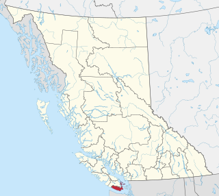
The Capital Regional District (CRD) is a local government administrative district encompassing the southern tip of Vancouver Island and the southern Gulf Islands in the Canadian province of British Columbia. The CRD is one of several regional districts in British Columbia and had an official population of 415,451 as of the Canada 2021 Census.

<span class="mw-page-title-main">Greater Victoria</span> Metropolitan area in British Columbia, Canada

Greater Victoria is located in British Columbia, Canada, on the southern tip of Vancouver Island. It is usually defined as the thirteen municipalities of the Capital Regional District (CRD) on Vancouver Island as well as some adjacent areas and nearby islands.

<span class="mw-page-title-main">Sooke</span> District municipality in British Columbia, Canada

Sooke is a district municipality on the southern tip of Vancouver Island, Canada, 38 kilometres (24 mi) by road from Victoria, the capital of British Columbia. Sooke, the westernmost of Greater Victoria's Western Communities, is to the north and west of the Sooke Basin. It is a regional centre for residents in neighbouring communities, including Otter Point, Shirley and Jordan River.

<span class="mw-page-title-main">Merritt, British Columbia</span> City in British Columbia, Canada

Merritt is a city in the Nicola Valley of the south-central Interior of British Columbia, Canada. It is 270 km (170 mi) northeast of Vancouver. Situated at the confluence of the Nicola and Coldwater rivers, it is the first major community encountered after travelling along Phase One of the Coquihalla Highway and acts as the gateway to all other major highways to the B.C. Interior. The city developed in 1893 when part of the ranches owned by William Voght, Jesus Garcia, and John Charters were surveyed for a town site.

<span class="mw-page-title-main">Duncan, British Columbia</span> City in British Columbia, Canada

Duncan is a city on southern Vancouver Island in British Columbia, Canada. It is the smallest city by area in Canada. It was incorporated in 1912.

The District of Highlands is a district municipality near Victoria, British Columbia, Canada. As one of the Western Communities, or West Shore municipalities, outside Victoria, Highlands has a population of 2,225 as of 2016. The region stretches along the Saanich Inlet shoreline from north of Goldstream to Mackenzie Bight. Highlands is one of the more undeveloped areas of the Greater Victoria region; it is one of the newest Greater Victoria municipalities created within the Capital Regional District.

<span class="mw-page-title-main">Regional District of Central Okanagan</span> Regional district in British Columbia, Canada

The Regional District of Central Okanagan (RDCO) is a regional district in the Canadian province of British Columbia, representing two unincorporated Electoral Areas of Central Okanagan East and Central Okanagan West, along with the member municipalities of the City of Kelowna, City of West Kelowna, the District of Lake Country, the District of Peachland, and Westbank First Nation. The RDCO office is located in Kelowna.

<span class="mw-page-title-main">North Cowichan</span> District municipality in British Columbia, Canada

North Cowichan is a district municipality established in 1873 on Vancouver Island, in British Columbia, Canada. The municipality is part of the Cowichan Valley Regional District. North Cowichan is noted for a landscape including forests, beaches, rivers, and lakes. The municipality encompasses the communities of Chemainus; Westholme; Crofton; Maple Bay; and "the South End". The latter is an informal name for a built-up area which is essentially a suburb of the City of Duncan, a separate municipality.

<span class="mw-page-title-main">Williams Lake, British Columbia</span> City in British Columbia, Canada

Williams Lake is a city in the Central Interior of British Columbia, in the central part of a region known as the Cariboo. Williams Lake is one of the largest cites, by population of metropolitan area, in the Cariboo after neighbouring Quesnel. The city is famous for the Williams Lake Stampede, which was once the second largest professional rodeo in Canada, after only the Calgary Stampede.

<span class="mw-page-title-main">Fraser Valley Regional District</span> Regional district in British Columbia, Canada

The Fraser Valley Regional District (FVRD) is a regional district in British Columbia, Canada. Its headquarters are in the city of Chilliwack. The FVRD covers an area of 13,361.74 km² (5,159 sq mi). It was created in 1995 by an amalgamation of the Fraser-Cheam Regional District and Central Fraser Valley Regional District and the portion of the Dewdney-Alouette Regional District from and including the District of Mission eastwards.

<span class="mw-page-title-main">Colwood, British Columbia</span> City in British Columbia, Canada

Colwood is a city located on Vancouver Island to the southwest of Victoria, capital of British Columbia, Canada. Colwood was incorporated in 1985 and has a population of approximately 19,000 people. Colwood lies within the boundaries of the Greater Victoria area or Capital Regional District, in a region called the Western Communities, or the West Shore. It is one of the 13 component municipalities of Greater Victoria.

<span class="mw-page-title-main">Enderby, British Columbia</span> City in British Columbia, Canada

The City of Enderby is in the North Okanagan region of the Canadian province of British Columbia, between Armstrong and Salmon Arm. It is approximately 80 km north of Kelowna and 130 km east of Kamloops. Highway 97A passes through Enderby and the Shuswap River marks the eastern and northeastern limits of the City. There are two major schools in Enderby: M.V. Beattie Elementary School and A.L. Fortune Secondary School. M.V. Beattie Elementary School was rebuilt in 2012.

The demographics of Metro Vancouver indicate a multicultural and multiracial region. Metro Vancouver is a metropolitan area, with its major urban centre being Vancouver, British Columbia, Canada. The Vancouver census metropolitan area, as defined by Statistics Canada, encompasses roughly the same territory as the Metro Vancouver Regional District, a regional district in British Columbia. The regional district includes 23 local authorities. Figures provided here are for the Vancouver census metropolitan area and not for the City of Vancouver.

<span class="mw-page-title-main">Kent, British Columbia</span> District municipality in British Columbia, Canada

The District of Kent is a district municipality located 116 kilometres (72 mi) east of Vancouver, British Columbia. Part of the Fraser Valley Regional District, Kent consists of several communities, the largest and most well-known being Agassiz—the only town in the municipality—Harrison Mills, Kilby, Mount Woodside, Kent Prairie, Sea Bird Island and Ruby Creek. Included within the municipality's boundaries are several separately-governed Indian reserves, including the Seabird Island First Nation's reserves on and around the island of the same name.

<span class="mw-page-title-main">Esquimalt—Saanich—Sooke</span> Federal electoral district in British Columbia, Canada

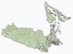
Esquimalt—Saanich—Sooke is a federal electoral district in Greater Victoria, on the southern tip of Vancouver Island in British Columbia, Canada.

École Secondaire Royal Bay Secondary School (RBSS) is a secondary school located in Colwood, a western suburb of Victoria, British Columbia, Canada. It is one of three secondary schools in School District 62 Sooke right now and serves the suburban Westshore area of Colwood, Langford and Metchosin.

References

  1. 1 2 "Langford, City [Census subdivision], British Columbia and Capital, Regional district [Census division], British Columbia". Statistics Canada. February 8, 2023. Retrieved March 20, 2023.
  2. "City of Langford – Home". Cityoflangford.ca.
  3. John Beadler. "Biography – LANGFORD, EDWARD EDWARDS – Volume XII (1891–1900) – Dictionary of Canadian Biography". Biographi.ca.
  4. 1 2 "Goldstream Provincial Park". Env.gov.bc.ca.
  5. "The gold rush at Goldstream, BC". Bcgoldrushpress.com.
  6. "Dunsmuir's Inaugural Train Trip – Goldstream Hotel – Old Langford excerpt". Maureenduffus.com.
  7. "Old Langford – An Illustrated History – Maureen Duffus". Maureenduffus.com.
  8. "City of Langford – Coat of Arms". Cityoflangford.ca. Archived from the original on 2016-10-26. Retrieved 2015-05-17.
  9. Akrigg, G.P.V.; Akrigg, Helen B. (1986), British Columbia Place Names (3rd, 1997 ed.), Vancouver: UBC Press, ISBN   0-7748-0636-2
  10. "Langford, B.C. ranked 3rd fastest growing city in Canada". 10 February 2022.
  11. "Langford leads growth in the province". Goldstreamgazette.com.
  12. "The road to hell". Focusonline.ca.
  13. "Millstream Village". Millstreamvillage.com.
  14. "Westshore Town Centre – Welcome to Westshore Town Centre!". Westshoretowncentre.com.
  15. "Cineplex.com – Cineplex Odeon Westshore". Cineplex.com.
  16. "Cineplex Odeon to Open New Multiplex at Westshore Town Centre | Douglas magazine". Archived from the original on 14 July 2014. Retrieved 2 February 2022.
  17. "New cinema complex in Langford ready to open – BC Local News". Bclocalnews.com.
  18. "Welcome to City Centre Park". Citycentrepark.ca. Retrieved 2 February 2022.
  19. "City of Langford – Family Fun Park". Cityoflangford.ca.
  20. "City of Langford – Veterans Memorial Park". Cityoflangford.ca. Archived from the original on 2015-06-02. Retrieved 2015-05-17.
  21. "Goldstream Station Market". Goldstreamstationmarket.ca.
  22. "Luxton Fall Fair". Luxtonfair.ca.
  23. "Rugby Canada". Rugbycanada.ca.
  24. "Westhills – YMCA/YWCA – Langford Aquatic Centre". Durwest.com.
  25. "City of Langford – YMCA/YWCA". Cityoflangford.ca.
  26. "The Westin Bear Mountain Golf Resort & Spa, Victoria". Bearmountain.ca.
  27. "Mountain Biking at Bear Mountain Resort". Bearmountain.ca. Archived from the original on 2016-03-12. Retrieved 2015-05-17.
  28. "South Island Disc Golf Society". Sidgs.org.
  29. "South Island Intro". Naturehouse.ca.
  30. "Goldstream Provincial Park, Salmon Run". Goldstreampark.com.
  31. "Canadian Climate Normals 1971–2000 Station Data". Climate.weather.gc.ca. 31 October 2011.
  32. "Archived copy" (PDF). Archived from the original (PDF) on 2015-09-24. Retrieved 2015-05-19.{{cite web}}: CS1 maint: archived copy as title (link)
  33. "Protecting our natives – Canadian Geographic Magazine: In-depth". Canadiangeographic.ca.
  34. "Population and dwelling counts: Canada, provinces and territories, and census subdivisions (municipalities), British Columbia". Statistics Canada. February 9, 2022. Retrieved February 20, 2022.
  35. "Census Profile, 2016 Census – Langford, City [Census subdivision], British Columbia and British Columbia [Province]". 12.statcan.gc.ca. 8 February 2017. Retrieved 2 February 2022.
  36. 1 2 Government of Canada, Statistics Canada (2022-10-26). "Census Profile, 2021 Census of Population". www12.statcan.gc.ca. Retrieved 2022-11-09.
  37. Government of Canada, Statistics Canada (2021-10-27). "Census Profile, 2016 Census". www12.statcan.gc.ca. Retrieved 2022-12-31.
  38. Government of Canada, Statistics Canada (2015-11-27). "NHS Profile". www12.statcan.gc.ca. Retrieved 2022-12-31.
  39. Government of Canada, Statistics Canada (2019-08-20). "2006 Community Profiles". www12.statcan.gc.ca. Retrieved 2022-12-31.
  40. Government of Canada, Statistics Canada (2019-07-02). "2001 Community Profiles". www12.statcan.gc.ca. Retrieved 2022-12-31.
  41. "Downtown". City of Langford. Retrieved 2023-12-11.
  42. 1 2 "Westhills BC – New Home Community in Victoria's Westshore". Westhillsbc.com.
  43. "Westhills". City of Langford. Retrieved 2023-12-11.
  44. "City of Langford – Happy Valley". Cityoflangford.ca.
  45. "City of Langford – Thetis Heights". Cityoflangford.ca.
  46. "Bear Mountain". City of Langford. Retrieved 2023-12-11.
  47. McLeod, Andrew (2014-05-15). "Who is John Horgan?". The Tyee. Retrieved 2019-06-26.
  48. "Our District | Sooke School District". 2023-12-13. Archived from the original on 2023-12-13. Retrieved 2023-12-13.
  49. 1 2 "New Schools – SD62 – School District #62 (Sooke)". Newschools.sd62.bc.ca.
  50. "Lighthouse Christian Academy – Christian Education in Victoria BC". Lighthousechristianacademy.com.
  51. "Communities – Quality Home Services". Bccommunitiesinbloom.ca.
  52. "Langford, B.C., wins national Golden Scissors Award". Archived from the original on 2014-03-28.
  53. "City of Langford – Affordable Housing Program". Cityoflangford.ca.
  54. 1 2 "City of Langford – Fire Department". Cityoflangford.ca.
  55. "West Shore RCMP – About West Shore RCMP". Westshore.rcmp-grc.gc.ca. 26 May 2016.
  56. "Westhills community in Langford expands its offerings". Vancouversun.com. Retrieved 2 February 2022.
  57. "'Boiling point': Malahat traffic angers commuters | CTV News". Vancouverisland.ctvnews.ca. Retrieved 2 February 2022.
  58. "Bear Mountain Resort developing next neighbourhood near Victoria". Biv.com. Retrieved 2 February 2022.
  59. "Alpine Group – Victoria BC". Alpinegroup.com.