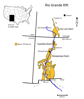
The Rio Grande rift is a north-trending continental rift zone. It separates the Colorado Plateau in the west from the interior of the North American craton on the east. The rift extends from central Colorado in the north to the state of Chihuahua, Mexico, in the south. The rift zone consists of four basins that have an average width of 50 kilometres (31 mi). The rift can be observed on location at Rio Grande National Forest, White Sands National Park, Santa Fe National Forest, and Cibola National Forest, among other locations.

Orogeny is a mountain building process that takes place at a convergent plate margin when plate motion compresses the margin. An orogenic belt or orogen develops as the compressed plate crumples and is uplifted to form one or more mountain ranges. This involves a series of geological processes collectively called orogenesis. These include both structural deformation of existing continental crust and the creation of new continental crust through volcanism. Magma rising in the orogen carries less dense material upwards while leaving more dense material behind, resulting in compositional differentiation of Earth's lithosphere. A synorogenic process or event is one that occurs during an orogeny.

Subduction is a geological process in which the oceanic lithosphere and some continental lithosphere is recycled into the Earth's mantle at convergent boundaries. Where the oceanic lithosphere of a tectonic plate converges with the less dense lithosphere of a second plate, the heavier plate dives beneath the second plate and sinks into the mantle. A region where this process occurs is known as a subduction zone, and its surface expression is known as an arc-trench complex. The process of subduction has created most of the Earth's continental crust. Rates of subduction are typically measured in centimeters per year, with rates of convergence as high as 11 cm/year.

The Basin and Range Province is a vast physiographic region covering much of the inland Western United States and northwestern Mexico. It is defined by unique basin and range topography, characterized by abrupt changes in elevation, alternating between narrow faulted mountain chains and flat arid valleys or basins. The physiography of the province is the result of tectonic extension that began around 17 million years ago in the early Miocene epoch.

The Farallon Plate was an ancient oceanic plate. It formed one of the three main plates of Panthalassa, alongside the Phoenix Plate and Izanagi Plate, which were connected by a triple junction. The Farallon Plate began subducting under the west coast of the North American Plate—then located in modern Utah—as Pangaea broke apart and after the formation of the Pacific Plate at the centre of the triple junction during the Early Jurassic. It is named for the Farallon Islands, which are located just west of San Francisco, California.
The Nevadan orogeny occurred along the western margin of North America during the Middle Jurassic to Early Cretaceous time which is approximately from 155 Ma to 145 Ma. Throughout the duration of this orogeny there were at least two different kinds of orogenic processes occurring. During the early stages of orogenesis an "Andean type" continental magmatic arc developed due to subduction of the Farallon oceanic plate beneath the North American Plate. The latter stages of orogenesis, in contrast, saw multiple oceanic arc terranes accreted onto the western margin of North America in a "Cordilleran type" accretionary orogen. Deformation related to the accretion of these volcanic arc terranes is mostly limited to the western regions of the resulting mountain ranges and is absent from the eastern regions. In addition, the deformation experienced in these mountain ranges is mostly due to the Nevadan orogeny and not other external events such as the more recent Sevier and Laramide Orogenies. It is noted that the Klamath Mountains and the Sierra Nevada share similar stratigraphy indicating that they were both formed by the Nevadan orogeny. In comparison with other orogenic events, it appears that the Nevadan Orogeny occurred rather quickly taking only about 10 million years as compared to hundreds of millions of years for other orogenies around the world.

The Sevier orogeny was a mountain-building event that affected western North America from northern Canada to the north to Mexico to the south.
The Lewis Overthrust is a geologic thrust fault structure of the Rocky Mountains found within the bordering national parks of Glacier in Montana, United States and Waterton Lakes in Alberta, Canada. The structure was created due to the collision of tectonic plates about 59-75 million years ago that drove a several mile thick wedge of Precambrian rock 50 mi (80 km) eastwards, causing it to overlie softer Cretaceous age rock that is 1300 to 1400 million years younger.
The Farallon Trench was a subduction related tectonic formation located off the coast of the western California continental margin during the late to mid Cenozoic era, around 50 miles southeast of modern-day Monterey Bay. The time duration of subduction began from around 165 Ma when the Farallon Plate replaced the Mezcalera promontory, until the San Andreas Fault straightening around 35 Ma. As data accumulated over time, a common view developed that one large oceanic plate, the Farallon Plate, acted as a conveyor belt, conveying accreted terranes onto the North American west coast. As the continent overran the subducting Farallon Plate, the denser plate became subducted into the mantle below the continent. When the plates converged, the dense oceanic plate sank into the mantle to form a slab below the lighter continent. Rapid subduction under the southwestern North America continent began 40 to 60 million years ago (Ma), during the mid Paleocene to mid Eocene epochs. This convergent subduction margin created a distinctive geomorphologic feature called an oceanic trench, which occurs at a convergent plate boundaries as a heavy metal rich, lithospheric plate moves below a light silica rich continental plate. The trench marks the position at which the flexed subducting slab begins to descend beneath and deform the continental plate margin. By 43 Ma, during the Eocene, worldwide plate motions changed and the Pacific Plate began to move away from North America and subduction of the Farallon Plate slowed dramatically. By around 36 Ma, the easternmost part of the East Pacific Rise, located between the Pioneer and Murray fracture zones at that time, approached the trench and the young, hot, buoyant lithosphere appears to have clogged part of the subduction zone, resulting in widespread dramatic uplift on land. The eventual complete subduction of this plate, consequential contact of the Pacific Plate with the California continental margin, and creation of the Mendocino Triple Junction (MTJ), took place around 30 to 20 Ma. The partial complete subduction and division of the Farallon Plate by the Pacific Plate, created the Juan de Fuca Plate to the north and the Cocos Plate to the south. The final stages of the evolution of California's continental margin was the growth of the San Andreas transform fault system, which formed as the Pacific Plate came into contact with the continental margin and the MTJ was formed. As subduction of the Pacific Plate continued along this margin, and the contact zone grew, the San Andreas proportionally grew as well.

The geology of the Rocky Mountains is that of a discontinuous series of mountain ranges with distinct geological origins. Collectively these make up the Rocky Mountains, a mountain system that stretches from Northern British Columbia through central New Mexico and which is part of the great mountain system known as the North American Cordillera.
Slab pull is a geophysical mechanism whereby the cooling and subsequent densifying of a subducting tectonic plate produces a downward force along the rest of the plate. In 1975 Forsyth and Uyeda used the inverse theory method to show that, of the many forces likely to be driving plate motion, slab pull was the strongest. Plate motion is partly driven by the weight of cold, dense plates sinking into the mantle at oceanic trenches. This force and slab suction account for almost all of the force driving plate tectonics. The ridge push at rifts contributes only 5 to 10%.

The Andean orogeny is an ongoing process of orogeny that began in the Early Jurassic and is responsible for the rise of the Andes mountains. The orogeny is driven by a reactivation of a long-lived subduction system along the western margin of South America. On a continental scale the Cretaceous and Oligocene were periods of re-arrangements in the orogeny. The details of the orogeny vary depending on the segment and the geological period considered.

The geology of North America is a subject of regional geology and covers the North American continent, the third-largest in the world. Geologic units and processes are investigated on a large scale to reach a synthesized picture of the geological development of the continent.

Flat slab subduction is characterized by a low subduction angle beyond the seismogenic layer and a resumption of normal subduction far from the trench. A slab refers to the subducting lower plate. A broader definition of flat slab subduction includes any shallowly dipping lower plate, as in western Mexico. Flat slab subduction is associated with the pinching out of the asthenosphere, an inland migration of arc magmatism, and an eventual cessation of arc magmatism. The coupling of the flat slab to the upper plate is thought to change the style of deformation occurring on the upper plate's surface and form basement-cored uplifts like the Rocky Mountains. The flat slab also may hydrate the lower continental lithosphere and be involved in the formation of economically important ore deposits. During the subduction, a flat slab itself may deform or buckle, causing sedimentary hiatus in marine sediments on the slab. The failure of a flat slab is associated with ignimbritic volcanism and the reverse migration of arc volcanism. Multiple working hypotheses about the cause of flat slabs are subduction of thick, buoyant oceanic crust (15–20 km) and trench rollback accompanying a rapidly overriding upper plate and enhanced trench suction. The west coast of South America has two of the largest flat slab subduction zones. Flat slab subduction is occurring at 10% of subduction zones.

The base of rocks that underlie Borneo, an island in Southeast Asia, was formed by the arc-continent collisions, continent–continent collisions and subduction–accretion due to convergence between the Asian, India–Australia, and Philippine Sea-Pacific plates over the last 400 million years. The active geological processes of Borneo are mild as all of the volcanoes are extinct. The geological forces shaping SE Asia today are from three plate boundaries: the collisional zone in Sulawesi southeast of Borneo, the Java-Sumatra subduction boundary and the India-Eurasia continental collision.

Patagonia comprises the southernmost region of South America, portions of which lie on either side of the Argentina-Chile border. It has traditionally been described as the region south of the Rio Colorado, although the physiographic border has more recently been moved southward to the Huincul fault. The region's geologic border to the north is composed of the Rio de la Plata craton and several accreted terranes comprising the La Pampa province. The underlying basement rocks of the Patagonian region can be subdivided into two large massifs: the North Patagonian Massif and the Deseado Massif. These massifs are surrounded by sedimentary basins formed in the Mesozoic that underwent subsequent deformation during the Andean orogeny. Patagonia is known for its vast earthquakes and the damage they cause.
The geology of Arizona began to form in the Precambrian. Igneous and metamorphic crystalline basement rock may have been much older, but was overwritten during the Yavapai and Mazatzal orogenies in the Proterozoic. The Grenville orogeny to the east caused Arizona to fill with sediments, shedding into a shallow sea. Limestone formed in the sea was metamorphosed by mafic intrusions. The Great Unconformity is a famous gap in the stratigraphic record, as Arizona experienced 900 million years of terrestrial conditions, except in isolated basins. The region oscillated between terrestrial and shallow ocean conditions during the Paleozoic as multi-cellular life became common and three major orogenies to the east shed sediments before North America became part of the supercontinent Pangaea. The breakup of Pangaea was accompanied by the subduction of the Farallon Plate, which drove volcanism during the Nevadan orogeny and the Sevier orogeny in the Mesozoic, which covered much of Arizona in volcanic debris and sediments. The Mid-Tertiary ignimbrite flare-up created smaller mountain ranges with extensive ash and lava in the Cenozoic, followed by the sinking of the Farallon slab in the mantle throughout the past 14 million years, which has created the Basin and Range Province. Arizona has extensive mineralization in veins, due to hydrothermal fluids and is notable for copper-gold porphyry, lead, zinc, rare minerals formed from copper enrichment and evaporites among other resources.
The geology of Wyoming includes some of the oldest Archean rocks in North America, overlain by thick marine and terrestrial sediments formed during the Paleozoic, Mesozoic and Cenozoic, including oil, gas and coal deposits. Throughout its geologic history, Wyoming has been uplifted several times during the formation of the Rocky Mountains, which produced complicated faulting that traps hydrocarbons.

The geology of Peru includes ancient Proterozoic rocks, Paleozoic and Mesozoic volcanic and sedimentary rocks, and numerous basins and the Andes Mountains formed in the Cenozoic.
The Nevadaplano was a high plateau that is proposed to have covered parts of southwestern North America during the late Mesozoic and early Cenozoic, located in the present-day US states of Idaho, Nevada, Utah and possibly others. It most likely formed during the Cretaceous as a consequence of subduction dynamics and may have reached elevations of 3 kilometres (9,800 ft) and more, although its elevation is controversial. It was flanked on the west by the Sierra Nevada, which was traversed by various valleys that came down from the Nevadaplano. Closed basins and numerous volcanic calderas covered the relatively flat Nevadaplano; large volcanic eruptions distributed ignimbrites over the plateau and down the valleys draining it.

