Lemon Grove, California

Last updated

Lemon Grove, California
Lemon Grove, CA Library (cropped).jpg
St. John of the Cross parish (cropped).jpg
- panoramio (4609) (cropped).jpg
Motto: 
Best Climate on Earth
San Diego County California Incorporated and Unincorporated areas Lemon Grove Highlighted 0641124.svg
Location of Lemon Grove in San Diego County, California.
Usa edcp relief location map.png
Red pog.svg
Lemon Grove, California
Location in the United States
Coordinates: 32°44′29″N117°01′54″W / 32.74139°N 117.03167°W / 32.74139; -117.03167
Country Flag of the United States (23px).png  United States
State Flag of California.svg  California
County Flag of San Diego County, California.png San Diego
Incorporated July 1, 1977 [1]
Government
  Type Council–manager
   Mayor Racquel Vasquez [2]
   City manager Lydia Romero [3]
Area
[4]
  Total3.88 sq mi (10.05 km2)
  Land3.88 sq mi (10.05 km2)
  Water0.00 sq mi (0.00 km2)  0%
Elevation
[5]
446 ft (136 m)
Population
 (2020)
  Total27,627
  Estimate 
(2021)
27,413
  Density7,100/sq mi (2,700/km2)
Time zone UTC-8 (Pacific)
  Summer (DST) UTC-7 (PDT)
ZIP code
91945
Area code 619
FIPS code 06-41124
GNIS feature IDs 1660902, 2410818
Website www.lemongrove.ca.gov

Lemon Grove is a city in San Diego County, California, United States. The population was 27,627 at the 2020 census, up from 25,320 at the 2010 census. [6]

Contents

History

The area that eventually became Lemon Grove was part of Mission San Diego de Alcalá, one of the Spanish missions in California. After Mexico became independent from Spain, the Californios (residents of Alta California) ranched on various land grants. The area that now includes Lemon Grove was granted to Santiago Argüello, who received more than 59,000 acres. [7]

The first proprietor of Lemon Grove, Robert Allison, arrived in the region in 1850, coming from Sacramento. He purchased thousands of acres from Santiago Argüello's heirs; this land eventually became Lemon Grove, La Mesa, Encanto, and part of Spring Valley. Allison became a director and stockholder of the San Diego and Cuyamaca Railroad in 1886 and built the Allison Flume. [7] Allison's son Joseph filed subdivision maps for "Lemon Grove" in 1892. The name is attributed to Joseph's mother, Tempa Waterman Allison. The climate was suitable for the cultivation of subtropical fruits and vegetables, and farmers from the East and Midwest flocked to the region. [7] The Lemon Grove Fruit Growers Association was formed in 1893; in 1894, the San Diego Union newspaper referred to Lemon Grove as "a sea of lemon trees." [7]

Joseph and Anton Sonka, immigrants from Bohemia, moved to Lemon Grove after stints in Seguin, Texas, and San Diego. The brothers opened a well-known general store, A. Sonka and Son. In 2023, the historical building that was once Sonka's general store became Lemon Grove Bistro.

Anthony "Tony" F. Sonka, the eldest son of Anton Sonka and his German American wife Anna Klein Sonka, was also a local notable. He was a key supporter of the huge lemon that became the town's symbol and landmark. [7] Sonka and a committee of local ranchers hired local architect Alberto Treganza to build the huge lemon to "make the ultimate statement about the town's purpose, prosperity, and optimism." [7]

In the Lemon Grove Incident in 1931, Mexican American parents in Lemon Grove pursued a successful judicial challenge against the decision of the local school board to build a separate school for Mexican American pupils. The decision of the Superior Court for San Diego County in Alvarez v. Lemon Grove was the first successful lawsuit against school segregation. [8] [9]

By World War II, most of the citrus groves had disappeared and suburbanization had begun. [7] There had been four elections on incorporation from the 1950s to the 1970s; the issue caused heated debate in the town. The city was finally incorporated on July 1, 1977, becoming California's 414th city. [7] Lemon Grove was incorporated as a general-law city; [10] however, it continues to receive law enforcement services, via contract, from the San Diego County Sheriff's Department. [11]

Geography

Lemon Grove is located at 32°44′0″N117°2′1″W / 32.73333°N 117.03361°W / 32.73333; -117.03361 (32.733451, −117.033702). [12]

According to the United States Census Bureau, the city has a total area of 3.9 square miles (10 km2), all land.

Transportation

The city is served by California State Routes 94 and 125. It is also served by the San Diego Trolley's Orange Line, at Lemon Grove Depot as well as at Massachusetts Avenue Station.

Demographics

Historical population
CensusPop.Note
1960 19,348
1970 19,6901.8%
1980 20,7805.5%
1990 23,98415.4%
2000 24,9183.9%
2010 25,3201.6%
2020 27,6279.1%
U.S. Decennial Census [13]

2010

At the 2010 census Lemon Grove had a population of 25,320. The population density was 6,525.3 inhabitants per square mile (2,519.4/km2). The racial makeup of Lemon Grove was 8,545 (33.3%) White, 3,495 (13.8%) African American, 225 (0.9%) Native American, 1,628 (6.3%) Asian, 275 (1.1%) Pacific Islander, 4,828 (19.1%) from other races, and 1,801 (7.1%) from two or more races. Hispanic or Latino of any race were 11,635 persons (45.2%). [14]

The census reported that 24,974 people (98.6% of the population) lived in households, 200 (0.8%) lived in non-institutionalized group quarters, and 146 (0.6%) were institutionalized.

There were 8,434 households, 3,295 (39.1%) had children under the age of 18 living in them, 3,863 (45.8%) were opposite-sex married couples living together, 1,419 (16.8%) had a female householder with no husband present, 601 (7.1%) had a male householder with no wife present. There were 516 (6.1%) unmarried opposite-sex partnerships, and 94 (1.1%) same-sex married couples or partnerships. 1,928 households (22.9%) were one person and 734 (8.7%) had someone living alone who was 65 or older. The average household size was 2.96. There were 5,883 families (69.8% of households); the average family size was 3.51.

The age distribution was 6,458 people (25.5%) under the age of 18, 2,583 people (10.2%) aged 18 to 24, 6,900 people (27.3%) aged 25 to 44, 6,550 people (25.9%) aged 45 to 64, and 2,829 people (11.2%) who were 65 or older. The median age was 35.0 years. For every 100 females, there were 95.3 males. For every 100 females age 18 and over, there were 93.6 males.

There were 8,868 housing units at an average density of 2,285.4 per square mile, of the occupied units 4,609 (54.6%) were owner-occupied and 3,825 (45.4%) were rented. The homeowner vacancy rate was 2.0%; the rental vacancy rate was 5.0%. 13,984 people (55.2% of the population) lived in owner-occupied housing units and 10,990 people (43.4%) lived in rental housing units.

2000

At the 2000 census there were 24,918 people in 8,488 households, including 5,958 families, in the city. The population density was 6,557.3 inhabitants per square mile (2,531.8/km2). There were 8,722 housing units at an average density of 2,295.2 per square mile (886.2/km2). The racial makeup of the city was 33.7% White, 13.9% African American, 0.4% Native American, 6.7% Asian, 0.8% Pacific Islander, 13.5% from other races, and 7.1% from two or more races. Hispanic or Latino of any race were 45.3%. [15]

Of the 8,488 households 36.4% had children under the age of 18 living with them, 49.0% were married couples living together, 15.6% had a female householder with no husband present, and 29.8% were non-families. 22.4% of households were one person and 8.9% were one person aged 65 or older. The average household size was 2.87 and the average family size was 3.36.

The age distribution was 27.6% under the age of 18, 9.0% from 18 to 24, 30.9% from 25 to 44, 20.5% from 45 to 64, and 12.0% 65 or older. The median age was 35 years. For every 100 females, there were 93.9 males. For every 100 females age 18 and over, there were 91.0 males.

The median household income was $39,823 and the median family income was $45,844. Males had a median income of $35,042 versus $28,509 for females. The per capita income for the city was $17,002. About 9.2% of families and 13.7% of the population were below the poverty line, including 18.0% of those under age 18 and 5.9% of those age 65 or over.

Current estimates

According to estimates by the San Diego Association of Governments, the median household income of Lemon Grove in 2005 was $55,436 (not adjusted for inflation). When adjusted for inflation (1999 dollars; comparable to Census data above), the median household income was $45,016.

Government

Lemon Grove sign. Lemon Grove, CA.jpg
Lemon Grove sign.

The City Council includes Mayor Racquel Vasquez, and Council members George Gastil, Alysson Snow, Liana LeBaron and Jennifer Mendoza. [16] The City Manager is Lydia Romero. [17]

In the California State Legislature, Lemon Grove is in the 39th Senate District , represented by Democrat Toni Atkins, and in the 79th Assembly district, represented by Democrat Akilah Weber . [18]

In the United States House of Representatives, Lemon Grove is in California's 51st congressional district , represented by Democrat Sara Jacobs. [19]

Notable people

"The World's Biggest Lemon"

Weighing some 3000 pounds, and approximately 10 feet long and six feet wide, the lemon sculpture—affectionately known as the World's Biggest Lemon—sits on a concrete base at the corner of Broadway and Lemon Grove Avenue, adjacent to 3361 Main Street. It lies before a small lemon grove beside the Orange Line Trolley tracks near the local trolley station and downtown bus stop. Written across the base of this monument are the words "Best Climate On Earth". Designed by Lemon Grove architect Alberto O Treganza, the lemon was originally built as a parade float for the 1928 Fourth of July Fiesta de San Diego parade, carrying the town's first Miss Lemon Grove, Amorita Treganza, Alberto's 16-year-old daughter. In 1930, the float was plastered to create a permanent sculpture and displayed near its current location.

Education

Public primary education in the city is provided by the Lemon Grove School District. Grossmont Union High School District provides secondary and adult education.

High schools

Eligible students are sent outside the town for secondary education.

Middle schools

K-8 schools

Elementary schools

See also

Related Research Articles

<span class="mw-page-title-main">San Joaquin, California</span> US city, incorporated 1920

San Joaquin is a city in Fresno County, California, United States. The population was 4,001 at the 2010 census, up from 3,270 at the 2000 census. The nearest high school in the area is Tranquillity High School in Tranquillity. San Joaquin is located 11 miles (18 km) southwest of Kerman, at an elevation of 174 feet.

<span class="mw-page-title-main">La Puente, California</span> City in California, United States

La Puente is a city in Los Angeles County, California, United States. The city had a population of 39,816 at the 2010 census and is approximately 20 miles (32 km) east of downtown Los Angeles.

<span class="mw-page-title-main">San Dimas, California</span> City in California, United States

San Dimas is a city in the San Gabriel Valley of Los Angeles County, California, United States. At the 2020 census, its population was 34,924. It historically took its name from San Dimas Canyon in the San Gabriel Mountains above the northern section of present-day San Dimas.

<span class="mw-page-title-main">South San Jose Hills, California</span> Census-designated place in California, United States

South San Jose Hills is an unincorporated community and census-designated place in Los Angeles County, California, United States. The population was 20,551 at the 2010 census, up from 20,218 at the 2000 census.

<span class="mw-page-title-main">Walnut, California</span> City in California, United States

Walnut is a city in the eastern part of Los Angeles County in the U.S. state of California. According to the 2010 census, the city had a population of 29,172, and the population was estimated to be 29,685 in 2019.

<span class="mw-page-title-main">West Whittier-Los Nietos, California</span> Census-designated place in California, United States

West Whittier-Los Nietos is a census-designated place (CDP) in Los Angeles County, California, near the San Gabriel River and the San Gabriel River (I-605) Freeway. The population was 25,540 at the 2010 census, up from 25,129 at the 2000 census. The census area consists of separate unincorporated communities of Los Nietos and West Whittier.

<span class="mw-page-title-main">San Jacinto, California</span> City in Riverside County in southern California, US

San Jacinto is a city in Riverside County, California, United States. It is located at the north end of the San Jacinto Valley, with Hemet to its south and Beaumont, California, to its north. The mountains associated with the valley are the San Jacinto Mountains. The population was 44,199 at the 2010 census. The city was founded in 1870 and incorporated on April 20, 1888, making it one of the oldest cities in Riverside County.

<span class="mw-page-title-main">Bonita, California</span> Census-designated place in California, United States

Bonita is a census-designated place (CDP) in southern San Diego County, California, nestled between the cities of Chula Vista, National City, and San Diego. The population was 12,538 at the 2010 census.

<span class="mw-page-title-main">Bonsall, California</span> Census-designated place in California, United States

Bonsall is a census-designated place (CDP) in San Diego County, California. The population was 3,982 at the 2010 census, up from 3,401 at the 2000 census.

<span class="mw-page-title-main">Harbison Canyon, California</span> Census-designated place in California, United States

Harbison Canyon is a census-designated place (CDP) in San Diego County, California. Harbison Canyon had a population of 4,048 as of the 2020 census, up from 3,841 as of the 2010 census.

<span class="mw-page-title-main">Jamul, California</span> Census designated place in California, United States

Jamul is a census-designated place (CDP) in San Diego County, California, United States. Jamul had a population of 6,163 at the 2010 census.

<span class="mw-page-title-main">La Mesa, California</span> City in California, United States

La Mesa is a city in San Diego County, located nine miles east of Downtown San Diego in Southern California. The population was 61,121 at the 2020 census, up from 57,065 at the 2010 census. Its civic motto is "the Jewel of the Hills."

<span class="mw-page-title-main">Rainbow, California</span> Census designated place in California, United States

Rainbow is a census designated place (CDP) in northern San Diego County in the U.S. state of California. The population was 1,832 at the 2010 census, down from 2,026 at the 2000 census.

<span class="mw-page-title-main">Valley Center, California</span> Census-designated place in California, United States

Valley Center is a census-designated place (CDP) in San Diego County, California, United States. The population was 9,277 at the 2010 census.

<span class="mw-page-title-main">Grayson, California</span> Place in California, United States

Grayson is an unincorporated community in Stanislaus County, California, United States. The population was 952 at the 2010 census, down from 1,077 at the 2000 census. For statistical purposes, the United States Census Bureau has defined Grayson as a census-designated place (CDP). It is part of the Modesto Metropolitan Statistical Area.

<span class="mw-page-title-main">Lemon Cove, California</span> Census designated place in California, United States

Lemon Cove is a census-designated place (CDP) in the San Joaquin Valley in Tulare County, California, United States. The population was 308 at the 2010 census, up from 298 at the 2000 census.

<span class="mw-page-title-main">Meiners Oaks, California</span> Unincorporated community in California, United States

Meiners Oaks is an unincorporated community lying west of the city of Ojai in Ventura County, California, United States. The population was 3,571 at the 2010 census. For statistical purposes, the United States Census Bureau has defined Meiners Oaks as a census-designated place (CDP).

<span class="mw-page-title-main">Council Grove, Kansas</span> City in Morris County, Kansas

Council Grove is a city and county seat in Morris County, Kansas, United States. As of the 2020 census, the population of the city was 2,140. It was named after an agreement between American settlers and the Osage Nation allowing settlers' wagon trains to pass westward through the area on the Santa Fe Trail. Pioneers gathered at a grove of trees so that wagons could band together for their trip west.

<span class="mw-page-title-main">Rancho San Diego, California</span> Census designated place in California, United States

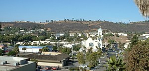
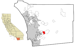
Rancho San Diego is a census-designated place (CDP) in the East County region of San Diego County, California. The population was 21,858 at the 2020 census, up from 21,208 at the 2010 census. The area was developed as subdivisions beginning in the 1970s.

<span class="mw-page-title-main">San Diego, Texas</span> City in Texas, United States

San Diego is a city in Duval and Jim Wells counties, Texas, United States. The population was 3,748 at the 2020 census and 4,488 at the 2010 census. It is located primarily in Duval County, of which it is the county seat.

References

  1. "California Cities by Incorporation Date". California Association of Local Agency Formation Commissions. Archived from the original (Word) on February 21, 2013. Retrieved August 25, 2014.
  2. "Mayor & Council". City of Lemon Grove. Retrieved February 24, 2015.
  3. "City Manager". City of Lemon Grove. Retrieved February 24, 2015.
  4. "2019 U.S. Gazetteer Files". United States Census Bureau. Retrieved July 1, 2020.
  5. "Lemon Grove". Geographic Names Information System . United States Geological Survey, United States Department of the Interior . Retrieved February 24, 2015.
  6. "U.S. Census Bureau QuickFacts: Lemon Grove city, California; United States". www.census.gov. Retrieved May 6, 2022.
  7. 1 2 3 4 5 6 7 8 Helen M. Ofield & Pete Smith, Images of America: Lemon Grove, Lemon Grove Historical Society (Arcadia: 2010).
  8. Matt S. Meier & Margo Gutiérrez, The Mexican American Experience: An Encyclopedia (Greenwood, 2003), p. 215.
  9. Mike Madrid, "The Lemon Grove Desegregation Case: A Matter of Neglected History" in Latino Civil Rights in Education: La Lucha Sigue (Routledge, 2016: eds. Anaida Colón-Muñiz & Magaly Lavadenz), pp. 52–57.
  10. "General law" means under the provisions established by the legislature, as opposed to a charter city which would have more local-government options. UCB Institute for Governmental Studies Archived June 12, 2008, at the Wayback Machine
  11. San Diego County Sheriff's Lemon Grove Station
  12. "US Gazetteer files: 2010, 2000, and 1990". United States Census Bureau. February 12, 2011. Retrieved April 23, 2011.
  13. "Census of Population and Housing". Census.gov. Retrieved May 15, 2023.
  14. "2010 Census Interactive Population Search: CA - Lemon Grove city". U.S. Census Bureau. Archived from the original on July 15, 2014. Retrieved July 12, 2014.
  15. "U.S. Census website". United States Census Bureau . Retrieved January 31, 2008.
  16. "Mayor and City Council | City of Lemon Grove, CA". www.lemongrove.ca.gov. Retrieved August 10, 2022.
  17. "Staff Directory List | City of Lemon Grove, CA". www.lemongrove.ca.gov. Retrieved March 14, 2023.
  18. "Statewide Database". UC Regents. Archived from the original on February 1, 2015. Retrieved November 24, 2014.
  19. "California's 53rd Congressional District - Representatives & District Map". Civic Impulse, LLC.
  20. John Forester's website with Lemon Grove address
  21. San Diego Reader, July 5, 2001
  22. ABDUSSATTAR SHAIKH
  23. Pearlman, Karen. "Shotgun Tom remembers his East County roots". sandiegouniontribune.com. Retrieved October 28, 2018.
  24. Hamblin, Abby (October 3, 2019). "Cartoonist Lalo Alcaraz's journey from Lemon Grove to Hollywood to improve Latino representation". San Diego Union.