Life zones of Peru

Last updated

When the Spanish arrived, they divided Peru into three main regions: the coastal region (11.6% of Peru), that is bounded by the Pacific Ocean; the highlands (28.1% of Peru), that is located on the Andean Heights, and the jungle, that is located on the Amazonian Jungle (Climate of Peru). But Javier Pulgar Vidal (es), a geographer who studied the biogeographic reality of the Peruvian territory for a long time, proposed the creation of eight Natural Regions. [1] [2] In 1941, he presented his thesis "Las Ocho Regiones Naturales del Perú" at the III General Assembly of the Pan-American Institute of Geography and History.

Contents

Peruvian natural regions. Regiones naturales del Peru.png
Peruvian natural regions.

These eight Peruvian regions are:

Example: Andes 10°S

See also Altitudinal zonation

Classic version, Amazonic side

Altitudinal variation in the Andes. Hoehenstufen der anden.en.PNG
Altitudinal variation in the Andes.

Javier Pulgar Vidal's version

The Peruvian geographer Javier Pulgar Vidal divided Peru in 8 regions (traditionally, it was costa, sierra and selva):

Map from República del Perú - Instituto Geográfico Nacional

Notes

Tropical and subtropical moist broadleaf forests

Montane grasslands and shrublands

Deserts and xeric shrublands

Overview - Amazonic side

Estimated temperatures - Continental Divide

Explanations:

  • Region, elevation (m); avg annual precipitation (mm); avg annual temperature (°C);
  • Peruvian Highland Rainforest (Tropical climate), Cloud forest (Subtropical climate) and Temperate forest (Temperate climate);
  • Cusco reference, estimated avg annual temperature (°C, Lowland Rainforest or Selva baja gets more rain, so it is more cloudy, so it is cooler);
  • Snow line reference, Humboldt cold current/ Pacific climate influence, estimated avg annual temperature (°C). [22]
    • Cuzco, Peru; 3,249 m; avg annual temperature 12.5 °C; avg annual precipitation 736 mm.
    • Lima, Peru; 30 m; avg annual temperature 19.2 °C (fog influence); avg annual precipitation 15 mm.
ElevationWest - Pacific sideEast - Amazonian side
Highland Rainforest or Selva alta400 m -26.5 °C
Loma-Vegetation500 mabout 21.1 °C -
Cloud forest or Fluvial Yunga1,000 m -23.5 °C
Quechua - Montane Valleys2,300 m -17.2 °C
Amazonian Tree line of Coniferae: 10 °Cabout 3,500 m -about 10 °C
Mountain pass influence4,100 mabout 3.4 °C(about 7.1 °C)
Vegetation endabout 4,800 mabout 0.0 °C -
Snow line about 5,000 mabout -1.0 °C -

Example: Kallawaya Region, Bolivia

Altitudinal zonation: Kallawaya Region, around Charazani, Bolivia (border to Peru).

See also

Related Research Articles

Tierra templada is a pseudo-climatological term used in Latin America to refer to places which are either located in the tropics at a moderately high elevation or are marginally outside the astronomical tropics, producing a somewhat cooler overall climate than that found in the tropical lowlands, the zone of which is known as the tierra caliente.

<span class="mw-page-title-main">Yungas</span> Natural region in Peru and Bolivia

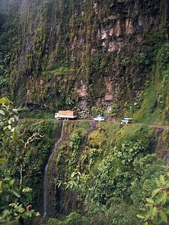
The Yungas is a bioregion of a narrow band of forest along the eastern slope of the Andes Mountains from Peru and Bolivia, and extends into Northwest Argentina at the slope of the Andes pre-cordillera. It is a transitional zone between the Andean highlands and the eastern forests. Like the surrounding areas, the Yungas belong to the Neotropical realm; the climate is rainy, humid, and warm.

<span class="mw-page-title-main">Puna grassland</span>

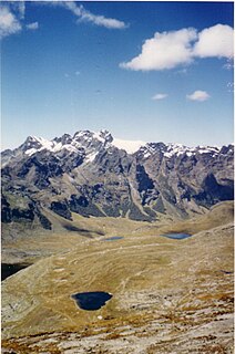
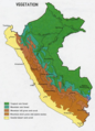
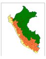
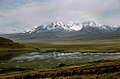
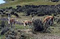
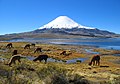
The puna grassland ecoregion, of the montane grasslands and shrublands biome, is found in the central Andes Mountains of South America. It is considered one of the eight Natural Regions in Peru, but extends south, across Chile, Bolivia, and western northwest Argentina. The term puna encompasses diverse ecosystems of the high Central Andes above 3200–3400 m.

<span class="mw-page-title-main">Central Andean dry puna</span>

The Central Andean dry puna (NT1001) is an ecoregion in the Montane grasslands and shrublands biome, located in the Andean high plateau, in South America. It is a part of the Puna grassland.

<span class="mw-page-title-main">Southern Andean Yungas</span> Ecoregion in Argentina and Bolivia

The Southern Andean Yungas is a tropical and subtropical moist broadleaf forest ecoregion in the Yungas of southwestern Bolivia and northwestern Argentina.

<span class="mw-page-title-main">Peruvian Yungas</span> Tropical and subtropical moist broadleaf forest ecoregion in the Yungas of Peru

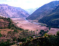
The Peruvian Yungas is a tropical and subtropical moist broadleaf forest ecoregion in the Yungas of Peru.

<span class="mw-page-title-main">Bolivian Yungas</span> Geographical region of Bolivia

The Bolivian Yungas is a tropical and subtropical moist broadleaf forest ecoregion in the Yungas of central Bolivia.

<span class="mw-page-title-main">Central Andean wet puna</span>

The Central Andean wet puna is a montane grasslands and shrublands ecoregion in the Andes of Peru and Bolivia.

<span class="mw-page-title-main">Solimões–Japurá moist forests</span> Ecoregion in the Amazon biome

The Solimões-Japurá moist forests (NT0163) is an ecoregion in northwest Brazil and eastern Peru and Colombia in the Amazon biome. It has a hot climate with high rainforest throughout the year, and holds one of the most diverse collections of fauna and flora in the world. The ecoregion is relatively intact.

<span class="mw-page-title-main">Iquitos várzea</span>

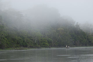
The Iquitos várzea (NT0128) is an ecoregion of flooded forest along rivers in Brazil, Peru and Bolivia in the west of the Amazon biome. The forest is seasonally flooded up to 7 metres (23 ft) by whitewater rivers carrying nutrient-rich sediment from the Andes. The meandering rivers often shift course, creating a complex landscape of oxbow lakes, marshes, levees and bars, with grasslands, shrubs and forests in different stages of succession. During the extended flood periods fish enter the forest in search of fruit. The várzea is accessible by the navigable rivers that run through it, and has suffered from extensive deforestation to extract timber and create pasture for livestock.

<span class="mw-page-title-main">Tumbes–Piura dry forests</span>

The Tumbes–Piura dry forests (NT0232) is an arid tropical ecoregion along the Pacific coasts of southern Ecuador and northern Peru. The ecoregion contains many endemic species of flora and birds adapted to the short wet season followed by a long dry season. Threats include extraction of wood for fuel or furniture, and capture of wild birds for sale.

<span class="mw-page-title-main">Marañón dry forests</span>

The Marañón dry forests (NT0223) is an ecoregion in northern Peru. It covers the lower valley of the Marañón River and its tributaries along the eastern edge of the Andes. It has a dry climate due to rain shadow from mountains further east. The habitat has long been modified by farming, ranching and logging and is now threatened by construction of hydroelectric and irrigation dams.

<span class="mw-page-title-main">Patía Valley dry forests</span>

The Patía Valley dry forests (NT0225) is an ecoregion in southwestern Colombia. It covers a dry valley surrounded by mountains. The original habitat has mostly been destroyed by human activity, although a few pockets remain.

<span class="mw-page-title-main">Northern Andean páramo</span>

The Northern Andean páramo (NT1006) is an ecoregion containing páramo vegetation above the treeline in the Andes of Colombia and Ecuador. In the past, when the climate was cooler, the treeline and the páramo units were lower and the units were connected. During the present warmer Holocene epoch the páramos have migrated uphill, shrinking and becoming isolated. They contain many rare or endangered species, some of them restricted to a narrow area of one mountain or mountain range. The ecoregion is relatively well preserved, but faces threats from over-grazing and farming.

<span class="mw-page-title-main">Cordillera Central páramo</span> Ecoregion in the Andes Mountains

The Cordillera Central páramo (NT1004) is an ecoregion containing páramo vegetation above the treeline in the Andes mountain range of northern Peru and southern Ecuador. Due to its isolation there are high levels of endemism. Despite many human settlements and some destruction of habitat by agriculture and mining, the ecoregion is relatively intact.

<span class="mw-page-title-main">Bolivian montane dry forests</span>

The Bolivian montane dry forests (NT0206) is an ecoregion in Bolivia on the eastern side of the Andes. It is a transitional habitat between the puna grasslands higher up to the west and the Chaco scrub to the east. The habitat is under severe stress from a growing human population.

<span class="mw-page-title-main">Napo moist forests</span>

The Napo moist forests (NT0142) is an ecoregion in the western Amazon rainforest of Colombia, Ecuador and Peru.

<span class="mw-page-title-main">Ucayali moist forests</span>

The Ucayali moist forests (NT0174) is an ecoregion in the western Amazon rainforest of Peru.

<span class="mw-page-title-main">Pacific Coastal Mountain icefields and tundra</span> Tundra ecoregion of Canada and the United States

Pacific Coastal Mountain icefields and tundra is a tundra ecoregion in Alaska, British Columbia, and Yukon, as defined by the World Wildlife Fund (WWF) categorization system.

References

  1. 1 2 Pulgar Vidal, Javier: Geografía del Perú; Las Ocho Regiones Naturales del Perú. Edit. Universo S.A., Lima 1979. First Edition (his dissertation of 1940): Las ocho regiones naturales del Perú, Boletín del Museo de Historia Natural „Javier Prado“, n° especial, Lima, 1941, 17, pp. 145-161.
  2. Benavides Estrada, Juan (1999); Geografía del Perú 2do año de Secuandaria. Lima: Escuela Nueva.
  3. Brigitta Schütt (2005); Azonale Böden und Hochgebirgsböden
  4. Zech, W. and Hintermaier-Erhard, G. (2002); Böden der Welt – Ein Bildatlas, Heidelberg, p. 98.
  5. Christopher Salter, Joseph Hobbs, Jesse Wheeler and J. Trenton Kostbade (2005); Essentials of World Regional Geography 2nd Edition. NY: Harcourt Brace. p.464-465.
  6. Middle America: Altitudinal Zonation Archived 2009-07-24 at the Wayback Machine
  7. "Cordillera Blanca, Peru (Huaraz, Caraz)". Archived from the original on 2012-03-12. Retrieved 2013-10-25. Maps of the Cordillera Blanca - Peru
  8. WWF Global 200: World Map of 14 Terrestrial Biomes and 867 Ecoregions
  9. "Bolivian Yungas". Terrestrial Ecoregions. World Wildlife Fund.
  10. 1 2 "Peruvian Yungas". Terrestrial Ecoregions. World Wildlife Fund.
  11. 1 2 "Southwest Amazon moist forests". Terrestrial Ecoregions. World Wildlife Fund.
  12. "Central Andean dry puna". Terrestrial Ecoregions. World Wildlife Fund.
  13. 1 2 "Central Andean puna". Terrestrial Ecoregions. World Wildlife Fund.
  14. "Central Andean wet puna". Terrestrial Ecoregions. World Wildlife Fund.
  15. "Atacama desert". Terrestrial Ecoregions. World Wildlife Fund.
  16. "Sechura desert". Terrestrial Ecoregions. World Wildlife Fund.
  17. "Gurupa varzea". Terrestrial Ecoregions. World Wildlife Fund.
  18. "Monte Alegre varzea". Terrestrial Ecoregions. World Wildlife Fund.
  19. "Purus varzea". Terrestrial Ecoregions. World Wildlife Fund.
  20. "Iquitos varzea". Terrestrial Ecoregions. World Wildlife Fund.
  21. "Central Andean wet puna". Terrestrial Ecoregions. World Wildlife Fund.
  22. Klimadiagramme weltweit - Europa
  23. Seibert, Paul; Farbatlas Südamerika, Verlag Eugen Ulmer, 1996.