List of National Natural Landmarks in California

Last updated

From List of National Natural Landmarks, these are the National Natural Landmarks in California. There are 37 in total. [1]

NameImageDateLocationCountyOwnershipDescription
Amboy Crater AmboyCraterInteriorMarch2010.JPG May 1973 34°31′11.69″N115°43′26.92″W / 34.5199139°N 115.7241444°W / 34.5199139; -115.7241444 San Bernardino Federal (Bureau of Land Management)A 6,000-year-old volcanic cinder cone, made up of pahoehoe, just off historic U.S. Highway 66.
American River Bluffs and Phoenix Park Vernal Pools Sac State American River from Guy West Bridge.jpg 1976 38°39′10.33″N121°12′59.95″W / 38.6528694°N 121.2166528°W / 38.6528694; -121.2166528 Sacramento Federal (United States Bureau of Reclamation), state (California State Parks), and municipal (Fair Oaks Recreation and Park District)Contains vernal pools, and blue oak woodlands. [2]
Año Nuevo State Reserve Ano Nuevo State Reserve.JPG 1980 37°7′7.24″N122°18′24.02″W / 37.1186778°N 122.3066722°W / 37.1186778; -122.3066722 San Mateo State (California Department of Parks and Recreation)One of the largest mainland breeding grounds for the northern elephant seal. [3]
Anza-Borrego Desert Fontspoint02262006.JPG 1974 33°14′57.38″N116°24′24.63″W / 33.2492722°N 116.4068417°W / 33.2492722; -116.4068417 Imperial, Riverside, San Diego State (California Department of Parks and Recreation)The largest desert state park in the nation. [4]
Audubon Canyon Historic Bourne house at Audubon Canyon Ranch nature preserve, in Stinson Beach.jpg 1968 37°55′46.01″N122°40′55.85″W / 37.9294472°N 122.6821806°W / 37.9294472; -122.6821806 Marin PrivateThe largest known nesting area for great blue herons and great and snowy egrets on the Pacific Coast. [5]
Black Chasm Cave
Black Chasm Cave Blackchasmflow.jpg
Black Chasm Cave
1976 38°26′3.4″N120°37′35.3″W / 38.434278°N 120.626472°W / 38.434278; -120.626472 Amador PrivateA small three-level cave containing a variety of speleothems and some of the best helictite formations in the western U.S. [6]
Burney Falls BurneyFalls.jpg 1984 41°0′43.79″N121°39′7″W / 41.0121639°N 121.65194°W / 41.0121639; -121.65194 Shasta State (California Department of Parks and Recreation)Contains some of the best examples in the western United States of a river drainage regulated by stratigraphically controlled springs. [7]
Cinder Cone Natural Area CimaDome82.jpg 1973 35°17′21.95″N115°35′6.99″W / 35.2894306°N 115.5852750°W / 35.2894306; -115.5852750 San Bernardino Federal (Mojave National Preserve)A complex of over 20 large cinder cones of recent origin with extensive and continuous lava flows. [8]
Cosumnes River Riparian Woodlands Cosumnes River Preserve.jpg 1976 38°15′56.57″N121°26′21.22″W / 38.2657139°N 121.4392278°W / 38.2657139; -121.4392278 Sacramento Private, Federal, State, and CountyA small remnant of a rapidly-disappearing riparian woodland community type that once formed a major part of the central valley. [9]
Deep Springs Marsh1975 37°20′00″N118°01′03″W / 37.33333°N 118.01750°W / 37.33333; -118.01750 Inyo PrivateAn example of increasingly rare desert marsh. [10]
Dixon Vernal Pools 1987 38°16′31.29″N121°49′25.49″W / 38.2753583°N 121.8237472°W / 38.2753583; -121.8237472 Solano PrivateThe best example of valley needlegrass grassland in the central valley. [11]
Elder Creek 1964 39°43′32.04″N123°37′34.35″W / 39.7255667°N 123.6262083°W / 39.7255667; -123.6262083 Mendocino State (University of California Natural Reserve System)A largely undisturbed watershed containing large old stands of Douglas fir, broadleaf evergreens, and deciduous trees. [12]
Emerald Bay Emerald Bay.jpg 1968 38°57′25.49″N120°5′36.3″W / 38.9570806°N 120.093417°W / 38.9570806; -120.093417 El Dorado State (California Department of Parks and Recreation)An outstanding example of glacial geology. [13]
Eureka Dunes EurekaDunesCA1.jpg 1983 37°5′45.6″N117°40′30″W / 37.096000°N 117.67500°W / 37.096000; -117.67500 Inyo Federal (Death Valley National Park)The tallest dune complex in the Great Basin. [14]
Fish Slough Area of Critical Environmental Concern 1975 37°28′8.69″N118°24′3.1″W / 37.4690806°N 118.400861°W / 37.4690806; -118.400861 Inyo, Mono Mixed- federal (Bureau of Land Management), state, municipalA large, essentially undisturbed, desert wetland that provides habitat for the alkali mariposa lily and the endangered Owens pupfish. [15]
Guadalupe-Nipomo Dunes US-CA-Mussel-Rock-Guadalupe-Beach.jpg 1974 34°57′56.13″N120°39′1.24″W / 34.9655917°N 120.6503444°W / 34.9655917; -120.6503444 San Luis Obispo Mixed- federal (Guadalupe-Nipomo Dunes National Wildlife Refuge), state, privateA coastal dune tract with off-road vehicle recreation, a national wildlife refuge, beaches, and nesting for the western snowy plover. [16]
Imperial Sand Hills Imperial sand dunes.jpg 1966 32°55′0″N115°3′0″W / 32.91667°N 115.05000°W / 32.91667; -115.05000 Imperial Federal (Bureau of Land Management)One of the largest dune patches in the United States. [17]
Irvine Ranch Natural Landmarks Crystal Cove State Park photo d ramey logan.jpg 2006 33°43′53.4″N117°41′34.8″W / 33.731500°N 117.693000°W / 33.731500; -117.693000 Orange Mixed- state, county, municipalA remarkably complete stratigraphic succession ranging in age from late Cretaceous to the present. [18]
Lake Shasta Caverns Shasta Caverns4.JPG May 2012 40°48′16.2″N122°18′15.98″W / 40.804500°N 122.3044389°W / 40.804500; -122.3044389 Shasta PrivateA well-decorated Solutional cave that contains a diverse assemblage of calcite cave formations. [19]
Lanphere Dunes and Ma-le'l Dunes 2021 Humboldt Federal (Bureau of Land Management, Humboldt Bay National Wildlife Refuge)Considered to be the largest and best quality sand dune ecosystems representing coastal dunes in the area. [20]
Miramar Mounds 1972 32°50′43″N117°8′19″W / 32.84528°N 117.13861°W / 32.84528; -117.13861 San Diego Federal (Marine Corps Air Station Miramar)Contains unique soil features called mima mounds, which are found in only three or four locations in the country, and vernal pools. [21]
Mitchell Caverns and Winding Stair Cave Mitchell Caverns Walkway.jpg 1975 34°56′26.97″N115°30′51.97″W / 34.9408250°N 115.5144361°W / 34.9408250; -115.5144361 San Bernardino State (California Department of Parks and Recreation)Regarded as the most important solution caverns in the Mojave Desert. [22]
Mt. Diablo State Park View of Mount Diablo and CA Highway 24 from Lafayette Heights.jpg 1982 37°52′37.75″N121°55′25.79″W / 37.8771528°N 121.9238306°W / 37.8771528; -121.9238306 Contra Costa State (California Department of Parks and Recreation)
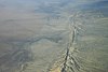
One of the few areas in the region where geologic strata of Jurassic, Cretaceous, and Tertiary age can be seen in an aggregate thickness of 42,000 feet (13,000 m). [23]
Mount Shasta MtShasta aerial.JPG 1976 41°24′35.6″N122°11′41.52″W / 41.409889°N 122.1948667°W / 41.409889; -122.1948667 Siskiyou Federal (Shasta-Trinity National Forest)One of the world's largest and most impressive stratovolcanoes, within the Shasta-Trinity National Forest. [24]
Pixley Vernal Pools 1987 35°59′3.85″N119°12′45.04″W / 35.9844028°N 119.2125111°W / 35.9844028; -119.2125111 Tulare PrivateOne of the few remaining natural vernal pools containing rare endemic crustacean species such as vernal pool fairy shrimp. [25]
Point Lobos Point Lobos 17.jpg 1967 36°31′1.56″N121°56′33.36″W / 36.5171000°N 121.9426000°W / 36.5171000; -121.9426000 Monterey State (California Department of Parks and Recreation)An outstanding example of terrestrial and marine environments in close association, and the only known habitat of Monterey cypress and variegated brodiaea. [26]
Pygmy Forest at Jug Handle State Natural Reserve Jug Handle Ecological Staircase Pygmy Forest (5063026514).jpg 1969

1973

39°22′29.3″N123°47′22.15″W / 39.374806°N 123.7894861°W / 39.374806; -123.7894861 Mendocino State (California Department of Parks and Recreation)Includes a five step ecological staircase on which a unique forest of low, stunted trees and shrubs is located. [27]
Rainbow Basin Rainbow Basin.JPG 1966 35°1′46″N117°2′12″W / 35.02944°N 117.03667°W / 35.02944; -117.03667 San Bernardino Federal (Bureau of Land Management)Deep erosion canyons with rugged rims with fossil evidence of insects and Miocene mammals. [28]
La Brea Tar Pits (Rancho La Brea) USA tar bubble la brea CA.jpg 1964 34°3′46.62″N118°21′21.49″W / 34.0629500°N 118.3559694°W / 34.0629500; -118.3559694 Los Angeles Municipal (City of Los Angeles)Site of the world-famous natural asphalt tar pits. [29]
San Andreas Fault Kluft-photo-Carrizo-Plain-Nov-2007-Img 0327.jpg 1965 San Benito PrivateOne of the best illustrations of earth displacement caused by small crustal movements. [30]
San Felipe Creek Area 1974 33°10′11″N115°49′19″W / 33.16972°N 115.82194°W / 33.16972; -115.82194 Imperial, San Diego Federal (Bureau of Land Management), state (California Department of Fish and Wildlife)A marsh containing probably the last remaining perennial natural desert stream in the Colorado Desert region. [31]
Sand Ridge Wildflower Preserve Sand Ridge Wildflower Preserve (16888144702).jpg 1984 35°18′31.26″N118°47′24.29″W / 35.3086833°N 118.7900806°W / 35.3086833; -118.7900806 Kern PrivateA remnant natural area displaying a great diversity of floral species including the Bakersfield cactus. [32]
Sharktooth Hill 1976 35°26′30.57″N118°56′26.18″W / 35.4418250°N 118.9406056°W / 35.4418250; -118.9406056 Kern PrivateOne of the most abundant, diverse and well- preserved fossil marine vertebrate sites in the world. [33]
Tijuana River Estuary Tijuana River Estuary.jpg 1973 32°33′7.2″N117°7′9.59″W / 32.552000°N 117.1193306°W / 32.552000; -117.1193306 San Diego Federal (Tijuana River National Estuarine Research Reserve), state, municipalOne of the finest remaining saltwater marshes on the California coastline. [34]
Torrey Pines State Reserve Torrey Pines State Park Valley.jpg 1977 32°54′59.58″N117°14′58.7″W / 32.9165500°N 117.249639°W / 32.9165500; -117.249639 San Diego State (California Department of Parks and Recreation)Contains a natural Torrey pine forest, high bluffs and sea cliffs, and endangered bird species. [35]
Trona Pinnacles BLM Winter Bucket List -7- Trona Pinnacles, California, for Out of This World Rock Formations (15515503494).jpg 1967 35°37′3.81″N117°22′5.08″W / 35.6177250°N 117.3680778°W / 35.6177250; -117.3680778 San Bernardino Federal (Bureau of Land Management)A relict landform from the Pleistocene containing unique formations of calcium carbonate. [36]
Turtle Mountain -WOMENINSTEM WEDNESDAY - -CONSERVATIONLANDS15 STYLE- BLM EMPLOYEE LARA KOBELT IN HER OWN WORDS (17134895706).jpg 1973 34°19′5.53″N114°51′7.28″W / 34.3182028°N 114.8520222°W / 34.3182028; -114.8520222 San Bernardino Federal (Bureau of Land Management), stateContains two mountain sections of entirely different composition. [37]

See also

Related Research Articles

<span class="mw-page-title-main">National Register of Historic Places listings in St. Louis County, Missouri</span>

This is a list of the National Register of Historic Places listings in St. Louis County, Missouri.

<span class="mw-page-title-main">Protected areas of California</span> Protected environmental areas of California, US

According to the California Protected Areas Database (CPAD), in the state of California, United States, there are over 14,000 inventoried protected areas administered by public agencies and non-profits. In addition, there are private conservation areas and other easements. They include almost one-third of California's scenic coastline, including coastal wetlands, estuaries, beaches, and dune systems. The California State Parks system alone has 270 units and covers 1.3 million acres (5,300 km2), with over 280 miles (450 km) of coastline, 625 miles (1,006 km) of lake and river frontage, nearly 18,000 campsites, and 3,000 miles (5,000 km) of hiking, biking, and equestrian trails.

<span class="mw-page-title-main">National Register of Historic Places listings in Shasta County, California</span>

This is a list of the National Register of Historic Places listings in Shasta County, California.

<span class="mw-page-title-main">National Register of Historic Places listings in Gloucester County, Virginia</span>

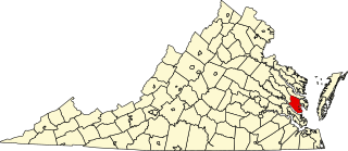
This is a list of the National Register of Historic Places listings in Gloucester County, Virginia.

<span class="mw-page-title-main">National Register of Historic Places listings in Apache County, Arizona</span>

This is a list of the National Register of Historic Places listings in Apache County, Arizona. It is intended to be a complete list of the properties and districts on the National Register of Historic Places in Apache County, Arizona, United States. The locations of National Register properties and districts for which the latitude and longitude coordinates are included below, may be seen in a map.

<span class="mw-page-title-main">National Register of Historic Places listings in Mille Lacs County, Minnesota</span>

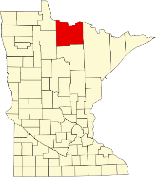
This is a list of the National Register of Historic Places listings in Mille Lacs County, Minnesota.

<span class="mw-page-title-main">National Register of Historic Places listings in Koochiching County, Minnesota</span>

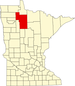
This is a list of the National Register of Historic Places listings in Koochiching County, Minnesota. It is intended to be a complete list of the properties and districts on the National Register of Historic Places in Koochiching County, Minnesota, United States. The locations of National Register properties and districts for which the latitude and longitude coordinates are included below, may be seen in an online map.

<span class="mw-page-title-main">National Register of Historic Places listings in Columbia, South Carolina</span>

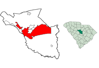
This is a list of the National Register of Historic Places listings in Columbia, South Carolina.

<span class="mw-page-title-main">National Register of Historic Places listings in Beltrami County, Minnesota</span>

This is a list of the National Register of Historic Places listings in Beltrami County, Minnesota. This is intended to be a complete list of the properties and districts on the National Register of Historic Places in Beltrami County, Minnesota, United States. The locations of National Register properties and districts for which the latitude and longitude coordinates are included below, may be seen in an online map.

<span class="mw-page-title-main">National Register of Historic Places listings in Lac qui Parle County, Minnesota</span>

This is a list of the National Register of Historic Places listings in Lac qui Parle County, Minnesota. It is intended to be a complete list of the properties and districts on the National Register of Historic Places in Lac qui Parle County, Minnesota, United States. The locations of National Register properties and districts for which the latitude and longitude coordinates are included below, may be seen in an online map.

<span class="mw-page-title-main">National Register of Historic Places listings in Mower County, Minnesota</span>

This is a list of the National Register of Historic Places listings in Mower County, Minnesota. It is intended to be a complete list of the properties and districts on the National Register of Historic Places in Mower County, Minnesota, United States. The locations of National Register properties and districts for which the latitude and longitude coordinates are included below, may be seen in an online map.

This is a list of the National Register of Historic Places listings in Lassen Volcanic National Park.

References

  1. "National Natural Landmarks Program, California". National Park Service. Retrieved 2013-01-04.
  2. "American River Bluffs and Phoenix Park Vernal Pools". www.nps.gov. Retrieved 2017-09-30.
  3. "Año Nuevo State Reserve". CA State Parks. Retrieved 2017-09-30.
  4. "Anza-Borrego Desert State Park". www.nps.gov. Retrieved 2017-09-30.
  5. "Audubon Canyon Ranch". www.nps.gov. Retrieved 2017-09-30.
  6. "Black Chasm Cave". www.nps.gov. Retrieved 2017-09-30.
  7. "Burney Falls". www.nps.gov. Retrieved 2017-09-30.
  8. "Cinder Cone Natural Area". www.nps.gov. Retrieved 2017-09-30.
  9. "Cosumnes River Preserve Visitor Center | BUREAU OF LAND MANAGEMENT". www.blm.gov. Retrieved 2017-09-30.
  10. "Deep Springs Marsh". www.nps.gov. Retrieved 2017-09-30.
  11. "Dixon Vernal Pools". www.nps.gov. Retrieved 2017-09-30.
  12. "Elder Creek". www.nps.gov. Retrieved 2017-09-30.
  13. "Emerald Bay". www.nps.gov. Retrieved 2017-09-30.
  14. "Eureka Dunes - Death Valley National Park (U.S. National Park Service)". www.nps.gov. Retrieved 2017-10-01.
  15. "Fish Slough Area of Critical Environmental Concern". www.blm.gov. Retrieved 2017-10-01.
  16. "Nipomo Dunes-Point Sal Coastal Area". www.nps.gov. Retrieved 2017-10-01.
  17. "Imperial Sand Hills". www.nps.gov. Retrieved 2017-10-01.
  18. "Irvine Ranch". www.nps.gov. Retrieved 2017-10-01.
  19. "Lake Shasta Caverns". www.nps.gov. Retrieved 2017-10-02.
  20. "High Plateaus, Smelly Caverns, and Coastal Dunes, Meet the Nation's Newest Natural Landmarks (U.S. National Park Service)". www.nps.gov. Retrieved 2021-04-19.
  21. "Miramar Mounds". www.nps.gov. Retrieved 2017-10-01.
  22. "Mitchell Caverns and Winding Stair Cave". www.nps.gov. Retrieved 2017-10-01.
  23. "Mount Diablo". www.nps.gov. Retrieved 2017-10-01.
  24. "Mount Shasta". www.nps.gov. Retrieved 2017-10-01.
  25. "Pixley Vernal Pools". CNLM. 22 May 2015. Retrieved 2017-10-01.
  26. "Point Lobos State Reserve". www.nps.gov. Retrieved 2017-10-01.
  27. "Jug Handle Ecological Staircase Trail - Mendocino Land Trust - 2017". Mendocino Land Trust 2017. Retrieved 2017-10-01.
  28. "Rainbow Basin". www.nps.gov. Retrieved 2017-10-01.
  29. "Rancho La Brea". www.nps.gov. Retrieved 2017-10-01.
  30. "San Andreas Fault". www.nps.gov. Retrieved 2017-10-01.
  31. "San Felipe Creek Area". www.nps.gov. Retrieved 2017-10-01.
  32. "Sand Ridge". CNLM. 7 December 2015. Retrieved 2017-10-01.
  33. Choi, Charles Q. (June 9, 2009). "Vast Bed of Ancient Bones and Shark Teeth Explained". Live Science. Retrieved 2017-10-02.
  34. "Tijuana River Estuary". www.nps.gov. Retrieved 2017-10-02.
  35. "Torrey Pines State Reserve". www.nps.gov. Retrieved 2017-10-02.
  36. "Trona Pinnacles". www.nps.gov. Retrieved 2017-10-02.
  37. "Turtle Mountaoins Wilderness". www.nps.gov. Retrieved 2017-10-02.