
The United States had an official estimated resident population of 334,914,895 on July 1, 2023, according to the U.S. Census Bureau. This figure includes the 50 states and the Washington, D.C. but excludes the population of five unincorporated U.S. territories as well as several minor island possessions. The United States is the third most populous country in the world, and the most populous in the Americas and the Western Hemisphere. The Census Bureau showed a population increase of 0.4% for the twelve-month period ending in July 2022, below the world average annual rate of 0.9%. The total fertility rate in the United States estimated for 2022 is 1.665 children per woman, which is below the replacement fertility rate of approximately 2.1. By several metrics, including racial and ethnic background, religious affiliation, and percentage of rural and urban divide, Illinois is the most representative of the larger demography of the United States.

Bethel Census Area is a census area in the U.S. state of Alaska. As of the 2020 census, the population is 18,666, up from 17,013 in 2010. It is part of the unorganized borough and therefore has no borough seat. Its largest community is the city of Bethel, which is also the largest city in the unorganized borough.

In the United States, a county or county equivalent is an administrative or political subdivision of a U.S. state or other territories of the United States which consists of a geographic area with specific boundaries and usually some level of governmental authority. The term "county" is used in 48 states, while Louisiana and Alaska have functionally equivalent subdivisions called parishes and boroughs, respectively. The specific governmental powers of counties vary widely between the states, with many providing some level of services to civil townships, municipalities, and unincorporated areas. Certain municipalities are in multiple counties; New York City is uniquely partitioned into five counties, referred to at the city government level as boroughs. Some municipalities have been consolidated with their county government to form consolidated city-counties, or have been legally separated from counties altogether to form independent cities. Conversely, those counties in Connecticut, Rhode Island, eight of Massachusetts's 14 counties, and Alaska's Unorganized Borough have no government power, existing only as geographic distinctions.

Glascock County is a county located in the U.S. state of Georgia. As of the 2020 census, the population was 2,884, making it the fourth-least populous county in Georgia. The county seat is Gibson. The county was created on December 19, 1857.

Clinch County is a county located in the southeastern part of the U.S. state of Georgia. As of the 2020 census, the population was 6,749. The county seat is Homerville. The county was created on February 14, 1850, named in honor of Duncan Lamont Clinch.

New Ashford is a town in Berkshire County, Massachusetts, United States. It is part of the Pittsfield, Massachusetts Metropolitan Statistical Area. The population was 250 at the 2020 census.
In 45 of the 50 states of the United States, the county is used for the level of local government immediately below the state itself. Louisiana uses parishes, and Alaska uses boroughs. In Connecticut, Massachusetts, and Rhode Island, some or all counties within states have no governments of their own; the counties continue to exist as legal entities, however, and are used by states for some administrative functions and by the United States Census bureau for statistical analysis. There are 3,242 counties and county equivalent administrative units in total, including the District of Columbia and 100 county-equivalents in the U.S. territories.

An urban area, built-up area or urban agglomeration is a human settlement with a high population density and an infrastructure of built environment. This is the core of a metropolitan statistical area in the United States, if it contains a population of more than 50,000.
Patoka Township is one of ten townships in Gibson County, Indiana, United States. As of the 2020 census, its population was 11,527 and it contained 5,309 housing units. It is the largest township in population, accounting for roughly 30% of the county's total population.

Posey Township is one of thirteen townships in Franklin County, Indiana, United States. As of the 2020 census, its population was 1,040, down from 1,051 at 2010.

Washington Township is the smallest of twelve townships in Harrison County, Indiana. As of the 2020 census, its population was 479 and it contained 215 housing units.
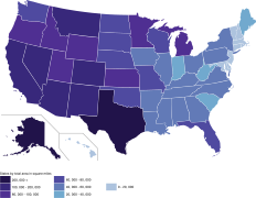 U.S. states by total area
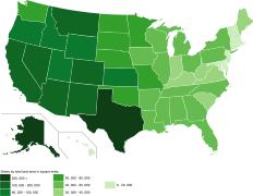 U.S. states by land area
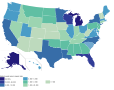 U.S. states by water area
 U.S. states by water percentage
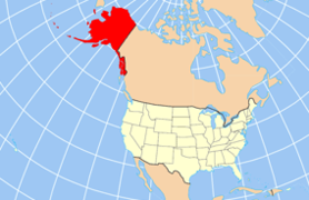 Alaska is the largest state by total area, land area, and water area. It is the seventh-largest country subdivision in the world. [5] [ failed verification ]
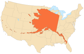 The area of Alaska is 18% of the area of the United States and equivalent to 21% of the area of the contiguous United States.
 The second largest state, Texas, has only 40% of the total area of the largest state, Alaska.
 Rhode Island is the smallest state by total area and land area.
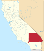 San Bernardino County is the largest county in the contiguous U.S. and is larger than each of the nine smallest states; it is larger than the four smallest states combined.
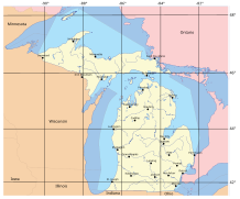 Michigan is second (after Alaska) in water area, and first in water percentage.
 Florida is mostly a peninsula, and has the third-largest water area and seventh-largest water area percentage.


