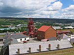
Caernarfon is a royal town, community and port in Gwynedd, Wales. It has a population of 9,852. It lies along the A487 road, on the eastern shore of the Menai Strait, opposite the island of Anglesey. The city of Bangor is 8.6 miles (13.8 km) to the north-east, while Snowdonia (Eryri) fringes Caernarfon to the east and south-east.

In the United Kingdom, a scheduled monument is a nationally important archaeological site or historic building, given protection against unauthorised change.

Cadw is the historic environment service of the Welsh Government and part of the Tourism and Culture group. Cadw works to protect the historic buildings and structures, the landscapes and heritage sites of Wales, to make them available for the public to visit, enjoy, and understand their significance. Cadw manages 127 state-owned properties and sites. It arranges events at its managed properties, provides lectures and teaching sessions, offers heritage walks, and hosts an online shop. Members of the public can become members of Cadw to gain membership privileges.

In the United Kingdom, a listed building is a structure of particular architectural and/or historic interest deserving of special protection. Such buildings are placed on one of the four statutory lists maintained by Historic England in England, Historic Environment Scotland in Scotland, Cadw in Wales, and the Northern Ireland Environment Agency in Northern Ireland. The classification schemes differ between England and Wales, Scotland, and Northern Ireland. The term has also been used in the Republic of Ireland, where buildings are protected under the Planning and Development Act 2000, although the statutory term in Ireland is "protected structure".
Clwyd is a preserved county of Wales, situated in the north-east corner of the country; it is named after the River Clwyd, which runs through the area. To the north lies the Irish Sea, with the English ceremonial counties of Cheshire to the east and Shropshire to the south-east. Powys and Gwynedd lie to the south and west respectively. Clwyd also shares a maritime boundary with Merseyside along the River Dee. Between 1974 and 1996, a slightly different area had a county council, with local government functions shared with six district councils. In 1996, Clwyd was abolished, and the new principal areas of Conwy County Borough, Denbighshire, Flintshire and Wrexham County Borough were created; under this reorganisation, "Clwyd" became a preserved county, with the name being retained for certain ceremonial functions.

The Llangollen Canal is a navigable canal crossing the border between England and Wales. The waterway links Llangollen in Denbighshire, north Wales, with Hurleston in south Cheshire, via the town of Ellesmere, Shropshire. The name, which was coined in the 1980s, is a modern designation for parts of the historic Ellesmere Canal and the Llangollen navigable feeder, both of which became part of the Shropshire Union Canals in 1846.

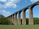
The Pontcysyllte Aqueduct is a navigable aqueduct that carries the Llangollen Canal across the River Dee in the Vale of Llangollen in northeast Wales.

Horseshoe Falls is a weir on the River Dee near Llantysilio Hall in Denbighshire, Wales, about 5 kilometres (3 mi) north-west of the town of Llangollen.

Wrexham County Borough is a county borough, with city status, in the north-east of Wales. It borders the English ceremonial counties of Cheshire and Shropshire to the east and south-east respectively, Powys to the south-west, Denbighshire to the west and Flintshire to the north-west. The city of Wrexham is the administrative centre. The county borough is part of the preserved county of Clwyd.

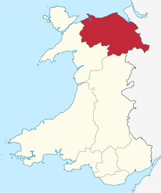
North Wales is a region of Wales, encompassing its northernmost areas. It borders mid Wales to the south, England to the east, and the Irish Sea to the north and west. The area is highly mountainous and rural, with Snowdonia National Park and the Clwydian Range and Dee Valley, known for its mountains, waterfalls and trails, wholly within the region. Its population is concentrated in the north-east and northern coastal areas, with significant Welsh-speaking populations in its western and rural areas. North Wales is imprecisely defined, lacking any exact definition or administrative structure. It is commonly defined administratively as its six most northern principal areas, but other definitions exist, with Montgomeryshire historically considered to be part of the region.

Aberffraw is a village and community on the south west coast of the Isle of Anglesey in Wales. The village is 9 miles from the island's capital, Llangefni, and is located is on the west bank of the Afon Ffraw. The community includes Soar and Dothan. Located near the A4080 and the nearest rail station is Bodorgan.

Chirk Aqueduct is a 70-foot (21 m) high and 710-foot (220 m) long navigable aqueduct that carries what is now the Llangollen Canal across the Ceiriog Valley near Chirk, on the England-Wales border, spanning the two countries.

The following outline is provided as an overview of and topical guide to Wales:

Wales, a country that is part of the United Kingdom, contains protected areas under various designations. The largest designation by land area is Wales' three national parks, followed by the five Areas of Outstanding Natural Beauty.

This is a timeline of Welsh history, comprising important legal and territorial changes, and political events in Wales.

The archaeology of Wales is the study of human occupation within the country of Wales which has been occupied by modern humans since 225,000 BCE, with continuous occupation from 9,000 BCE. Analysis of the sites, artefacts and other archaeological data within Wales details its complex social landscape and evolution from Prehistoric times to the Industrial period. This study is undertaken by academic institutions, consultancies, charities as well as government organisations.

Porth yr Aur is a Grade I listed 13th-century fortification in Caernarfon which forms part of Caernarfon Castle's medieval defences. Originally known as the West gate it was the main seaward entrance to the walled town. The building has been the home of the Royal Welsh Yacht Club since 1854. Porth yr Aur forms part of the Castles and Town Walls of King Edward in Gwynedd UNESCO world heritage site.
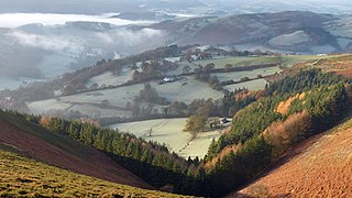
The Clwydian Range and Dee Valley is a designated Area of Outstanding Natural Beauty (AONB) located in north-east Wales, covering the Clwydian Range, and the valley of the River Dee.

The Cefn (Newbridge) Viaduct is Grade II* listed railway viaduct across the River Dee between Cefn and Chirk communities in Wrexham County Borough, Wales. The viaduct is near the villages of Cefn Mawr, Pentre and Newbridge. The viaduct forms the eastern boundary of Tŷ Mawr Country Park and is around a mile downstream of Pontcysyllte Aqueduct.