


This is a list of cities, municipalities, and towns in Tanzania .
This is a list of cities, municipalities, and towns in Tanzania .
| Rank | City | 1978 | 1999 | 2002 [1] | 2012 [2] | Region |
|---|---|---|---|---|---|---|
| 1. | Dar es Salaam | - | 1,205,443 | 2,339,910 | 4,364,541 [N 1] | Dar es Salaam |
| 2. | Mwanza | 110,553 | 172,287 | 385,810 | 706,543 [N 2] | Mwanza |
| 3. | Arusha | 55,223 | 102,544 | 333,791 | 416,442 [N 3] | Arusha |
| 4. | Mbeya | 76,601 | 130,798 | 266,422 | 385,279 [N 4] | Mbeya |
| 5. | Morogoro | 60,782 | 117,760 | 228,863 | 315,866 [N 5] | Morogoro |
| 6. | Tanga | 103,399 | 137,364 | 243,580 | 273,332 [N 6] | Tanga |
| 7. | Kahama | – | – | – | 242,208 [N 7] | Shinyanga |
| 8. | Tabora | 67,388 | 92,779 | 135,243 | 226,999 [N 8] | Tabora |
| 9. | Zanzibar City | 110,531 | 157,634 | 206,292 | 223,033 [N 9] | Zanzibar West |
| 10. | Kigoma | 50,075 | 74,224 | 144,852 | 215,458 [N 10] | Kigoma |
| 11. | Dodoma | 45,807 | 83,205 | 150,604 | 213,636 [N 11] | Dodoma |
| 12. | Sumbawanga | 28,586 | 47,878 | 80,284 | 209,793 [N 12] | Rukwa |
| 13. | Kasulu | – | – | – | 208,244 [N 13] | Kigoma |
| 14. | Songea | 17,955 | 52,985 | 108,771 | 203,309 [N 14] | Ruvuma |
| 15. | Moshi | 52,046 | 96,838 | 144,336 | 184,292 [N 15] | Kilimanjaro |
| 16. | Musoma | 31,051 | 63,652 | 108,242 | 178,356 [N 16] | Mara |
| 17. | Shinyanga | 20,439 | 46,802 | 135,166 | 161,391 [N 17] | Shinyanga |
| 18. | Iringa | 57,164 | 84,860 | 106,668 | 151,345 [N 18] | Iringa |
| 19. | Singida | 29,258 | 39,598 | 115,354 | 150,379 [N 19] | Singida |
| 20. | Njombe | – | 25,213 | 42,332 | 130,223 [N 20] | Njombe |
| 21. | Bukoba | 21,547 | 28,702 | 61,652 | 128,796 [N 21] | Kagera |
| 22. | Kibaha | – | – | – | 128,488 [N 22] | Pwani |
| 23. | Mtwara | 48,491 | 66,452 | 92,602 | 108,299 [N 23] | Mtwara |
| 24. | Mpanda | 13,450 | 41,014 | 45,977 | 102,900 [N 24] | Katavi |
| 25. | Tunduma | – | – | 34,461 | 97,562 [N 25] | Mbeya |
| 26. | Makambako | – | – | 51,049 | 93,827 [N 26] | Njombe |
| 27. | Babati | – | – | – | 93,108 [N 27] | Manyara |
| 28. | Handeni | – | – | – | 79,056 [N 28] | Tanga |
| 29. | Lindi | 27,312 | 41,587 | 41,549 | 78,841 [N 29] | Lindi |
| 30. | Korogwe | – | – | – | 68,308 [N 30] | Tanga |
| 31. | Mafinga | – | – | – | 51,902 [N 31] | Iringa |
| 32. | Nansio | – | – | – | 50,500 [N 32] | Mwanza |

Dar es Salaam is the largest city and financial hub of Tanzania. It is also the capital of the Dar es Salaam Region. With a population of over five million people, Dar es Salaam is the largest city in East Africa and the sixth-largest in Africa. Located on the Swahili coast, Dar es Salaam is an important economic center and one of the fastest-growing cities in the world.

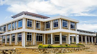
Dodoma, officially Dodoma City, is the capital of Tanzania and the administrative capital of both Dodoma Municipal Council and the entire Dodoma Region, with a population of 765,179. In 1974, the Tanzanian government announced that Tanzania's federal capital would be moved from Dar es Salaam to Dodoma for social and economic reasons and to centralise the capital within the country. It became the official capital in 1996.

Lindi is a historic southern Tanzanian coastal town and regional capital of the Lindi Region. The town is located at the far end of Lindi Bay on the Indian Ocean in southeastern Tanzania. The town is 450 kilometres (280 mi) south of Dar es Salaam and 105 km (65 mi) north of Mtwara, the southernmost coastal town in Tanzania, and gives its name to the surrounding Lindi Region. The Lindi Region is a large, yet sparsely populated, region of Tanzania.

Iringa is a city in Tanzania with a population of 202,490 and situated at a latitude of 7.77°S and longitude of 35.69°E. The name is derived from the Hehe word lilinga, meaning fort. Iringa is the administrative capital of Iringa Region. Iringa Municipal Council is the administrative designation of the Municipality of Iringa. Iringa has been one of the coldest regions in Tanzania due to its geographical location but that has attracted a lot of tourists from colder regions abroad especially Western Europe. Iringa also hosts one of Africa’s largest national parks the Ruaha National Park.

Kariakoo is an administrative ward of the Ilala Municipical Council of the Dar es Salaam Region in Tanzania. Jangwani ward and Mchafukoge ward form the ward's northern and eastern boundaries. The Gerezani and Mchikichini wards border the ward to the south and west respectively. The ward is the home of Simba Sports Club. The name is derived from the swahilization of the British colonial occupation's "Carrier Corps", that used to be based in the area. Today, Kariakoo is mainly known for its large market that spans several city blocks. According to the 2012 census, the ward has a population of 13,780.

Songea is the capital of Ruvuma Region in southwestern Tanzania. It is located along the A19 road. The city has a population of 286,285, and is the seat of the Roman Catholic Archdiocese of Songea. Between 1905 and 1907, the city was a centre of African resistance during the Maji Maji Rebellion in German East Africa. The city is poised to experience significant economic growth in the near future as the Mtwara Corridor opens up in a few years. It is projected to be the sixth fastest growing city on the African continent between 2020 and 2025, with a 5.74% growth.

Dar es Salaam Region is one of Tanzania's 31 administrative regions and is located in the east coast of the country. The region covers an area of 1,393 km2 (538 sq mi). The region is comparable in size to the combined land and water areas of the nation state of Mauritius Dar es Salaam Region is bordered to the east by Indian Ocean and it is entirely surrounded by Pwani Region. The Pwani districts that border Dar es Salaam region are Bagamoyo District to the north, Kibaha Urban District to the west, Kisarawe District to the south west and Mkuranga District to the south of the region. The region's seat (capital) is located inside the ward of Ilala. The region is named after the city of Dar es Salaam itself. The region is home to Tanzania's major finance, administration and industries, thus the making it the country's richest region. The region also has the second highest Human Development Index in the country after Mjini Magharibi. According to the 2022 census, the region has a total population of 5,383,728 and national census of 2012 had 4,364,541. The region has the highest population in Tanzania followed by Mwanza Region.
Iringa Region is one of Tanzania's 31 administrative regions. The region covers an area of 35,503 km2 (13,708 sq mi). The region is comparable in size to the combined land area of the nation state of Guinea Bissau. Iringa Region is bordered to the east by Morogoro Region and south by Njombe Region. On the west the region is bordered by Mbeya Region. Dodoma Region and Singida Region border Iringa on the north. The regional capital is the city Iringa for which the city is named after. According to the 2022 census, the region has a total population of 1,192,728. Iringa Region is home to Ruaha National Park, Tanzania's second national largest park.

Temeke District, officially the Temeke Municipal Council is one of five districts of the Dar es Salaam Region of Tanzania. Temeke is bordered to the south by the Mkuranga District of the Pwani Region, to the north by the Indian Ocean, and to the northwest by the Ilala District. Temeke's eastern boundary is shared by Kigamboni District. The district covers an area of 150.4 km2 (58.1 sq mi). The district is comparable in size to the land area of Cook Islands. The administrative seat is Miburani. The district is home to the University of Dar es Salaam's School of Education, the National Stadium, the largest stadium in the country, Port of Dar es Salaam the largest port in the country, and The Chamazi Stadium the largest privately owned stadium. The 2012 National Tanzania Census states the population of the district as 1,205,949.

Ilala District, officially the Ilala Municipal Council is one of five districts of the Dar es Salaam Region of Tanzania. The district is bordered to the north and northeast by Kinondoni District and Ubungo District, to the east by the Zanzibar Channel, the west by Pwani Region, and to the south by the Temeke District. It covers an area of 364.9 km2 (140.9 sq mi). The district is comparable in size to the land area of U.S Virgin Islands. The administrative seat is Mchafukoge. The 2012 National Tanzania Census states the population for Ilala as 1,220,611.

Ubungo District, officially the, Ubungo Municipal Council is one of five districts of the Dar es Salaam Region of Tanzania. The Kinondoni District and Kibaha of the Pwani Region border the district to the north; the Kisarawe District of Pwani Region borders it to the west; and the Ilala District borders the it to the south and east. The district covers an area of 269.4 km2 (104.0 sq mi). The district is comparable in size to the land area of St. Kitts and Nevis. The administrative seat is Kwembe. The district is home to the University of Dar es Salaam, The Magufuli Bus Terminal, the largest in the country, and Pande Game Reserve the largest protected land area in Dar es Salaam Region. In addition, the district is home to the largest natural gas powered power station, the Ubungo Thermal Power Station and the headquarters of the Tanzania Electric Supply Company Limited (TANESCO). The 2012 National Tanzania Census states the population of the district as 845,368.

Tabora Urban is one of the seven districts in the Tabora Region of Tanzania. This district is mostly the city of Tabora and its suburbs. It is bordered almost completely by the Uyui District. It has a small border with Nzega District to the north. Its administrative seat is the city of Tabora.
As of 2021, there are 31 regions of Tanzania which are divided into 184 districts.

Kurasini is an administrative ward in the Temeke district of the Dar es Salaam Region of Tanzania. Home of The Dar es Salaam Port, It is the location of the Port of Dar es Salaam; the fourth-largest port in Africa on the Indian Ocean, The National Police College, the Mgulani Police Barracks, Tanzania Immigration Headquarters, Diplomacy College and the Dar es Salaam International Trade Fair Grounds. Kurasini, under the British occupation of Tanganyika was built before 1940 for European port officials only. According to the 2012 census, the ward has a total population of 26,193.
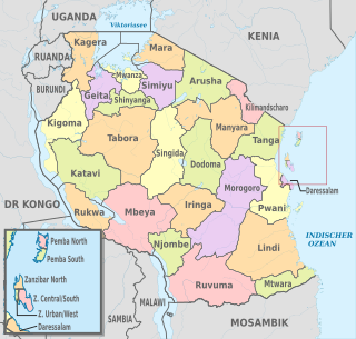
The administrative divisions of Tanzania are controlled by Part I, Article 2.2 of the Constitution of Tanzania. Tanzania is divided into thirty-one regions. Each region is subdivided into districts. The districts are sub-divided into divisions and further into local wards. Wards are further subdivided for management purposes: for urban wards into streets and for rural wards into villages. The villages may be further subdivided into hamlets.

Water supply and sanitation in Tanzania is characterised by: decreasing access to at least basic water sources in the 2000s, steady access to some form of sanitation, intermittent water supply and generally low quality of service. Many utilities are barely able to cover their operation and maintenance costs through revenues due to low tariffs and poor efficiency. There are significant regional differences and the best performing utilities are Arusha and Tanga.
The following is a timeline of the history of the city of Dar es Salaam, Tanzania.
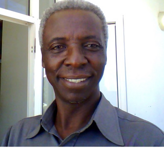
Davis George Mwamfupe is Mayor of Dodoma, the Capital City of The United Republic of Tanzania. He is a member of the CCM, and a professor at the Dodoma University. He also served at the University of Dar es Salaam from 2005 to 2008.
The Mayor of Dodoma is the head of the municipal government of Dodoma, the capital city of Tanzania. The current mayor is Davis G. Mwamfupe, who took office on 1 July 2016. The City Council members elect the mayor. The Mayor is selected for a three-year term and can be re-elected at a local government election, or may be chosen from within the council at a meeting.

Mtwara Mikindani Municipal District Council is one of eight regional councils of the Mtwara Region in Tanzania. It is bordered to the north by the Lindi Region, to the east by the Indian Ocean and to the south and west by the Mtwara District. In 2016, the municipality has a total population of 113,732.
![]() Media related to Cities in Tanzania at Wikimedia Commons
Media related to Cities in Tanzania at Wikimedia Commons
