Related Research Articles
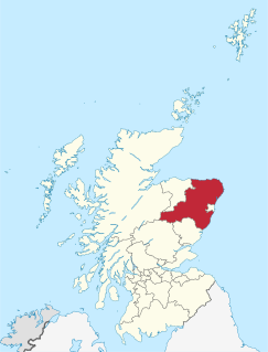
Aberdeenshire is one of the 32 council areas of Scotland.

The Highlands is a historical region of Scotland. Culturally, the Highlands and the Lowlands diverged from the Late Middle Ages into the modern period, when Lowland Scots replaced Scottish Gaelic throughout most of the Lowlands. The term is also used for the area north and west of the Highland Boundary Fault, although the exact boundaries are not clearly defined, particularly to the east. The Great Glen divides the Grampian Mountains to the southeast from the Northwest Highlands. The Scottish Gaelic name of A' Ghàidhealtachd literally means "the place of the Gaels" and traditionally, from a Gaelic-speaking point of view, includes both the Western Isles and the Highlands.
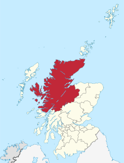
Highland is a council area in the Scottish Highlands and is the largest local government area in the United Kingdom. It was the 7th most populous council area in Scotland at the 2011 census. It shares borders with the council areas of Aberdeenshire, Argyll and Bute, Moray and Perth and Kinross. Their councils, and those of Angus and Stirling, also have areas of the Scottish Highlands within their administrative boundaries.

Moray is one of the 32 local government council areas of Scotland. It lies in the north-east of the country, with a coastline on the Moray Firth, and borders the council areas of Aberdeenshire and Highland.
Local government in Scotland is organised through 32 unitary authorities designated as councils which consist of councillors elected every five years by registered voters in each of the council areas.

The shires of Scotland, or counties of Scotland, are historic subdivisions of Scotland established in the Middle Ages and used as administrative divisions until 1975. Originally established for judicial purposes, from the 17th century they started to be used for local administration purposes as well. The areas used for judicial functions (sheriffdoms) came to diverge from the shires, which ceased to be used for local government purposes after 1975 under the Local Government (Scotland) Act 1973.
Lieutenancy areas are the separate areas of the United Kingdom appointed a lord-lieutenant – a representative of the British monarch. In many cases they have similar demarcation and naming to, but are not necessarily conterminate with, the counties of the United Kingdom.

Westhill is a town in Aberdeenshire, Scotland, approximately 7 miles (11 km) west of the city of Aberdeen.
The Royal Incorporation of Architects in Scotland (RIAS) is the professional body for architects in Scotland.

Aberdeenshire or the County of Aberdeen is a historic county and registration county of Scotland. The area of the county, excluding the city of Aberdeen itself, is also a lieutenancy area. The county borders Kincardineshire, Angus and Perthshire to the south, Inverness-shire and Banffshire to the west, and the North Sea to the north and east. It has a coast-line of 65 miles (105 km).

Aberdeen South is a burgh constituency of the House of Commons of the Parliament of the United Kingdom and it elects one Member of Parliament (MP) by the first-past-the-post system of election.

Aberdeen North is a burgh constituency of the House of Commons of the Parliament of the United Kingdom and it elects one Member of Parliament (MP) by the first past the post system of election. It was first used in the 1885 general election, but has undergone various boundary changes since that date.

Gordon is a county constituency of the House of Commons of the Parliament of the United Kingdom (Westminster), which elects one member of Parliament (MP) by the first past the post system of election. The constituency first returned a member in the 1983 general election, but has undergone boundary changes since that date.

St Cyrus or Saint Cyrus, formerly Ecclesgreig is a village in the far south of Aberdeenshire, Scotland.

The following is an alphabetical list of articles related to the United Kingdom of Great Britain and Northern Ireland.
This is a list of listed buildings in Scotland. The list is split out by council area.
References
- "Scotland Table 1" A Vision of Britain. Retrieved 27 December 2007.
- Keay, J. & Keay, J. (1994) Collins Encyclopaedia of Scotland. London. HarperCollins.
- "Scotland Table 1" A Vision of Britain. Retrieved 27 December 2007.