Local Government (Scotland) Act 1889

Last updated

Local Government (Scotland) Act 1889
Royal Coat of Arms of the United Kingdom (HM Government).svg
Long title An Act to amend the Laws relating to Local Government in Scotland.
Citation 52 & 53 Vict. c. 50
Territorial extent Scotland
Dates
Royal assent 26 August 1889
Commencement 15 May 1890
Other legislation
Repealed by Local Government (Scotland) Act 1929
Relates to Local Government Act 1888 (E&W)
Status: Repealed
Text of statute as originally enacted

The Local Government (Scotland) Act 1889 (52 & 53 Vict. c. 50) is an Act of the Parliament of the United Kingdom which was passed on 26 August 1889. The main effect of the act was to establish elected county councils in Scotland. In this it followed the pattern introduced in England and Wales by the Local Government Act 1888.

Contents

County councils

The act provided that a county council should be established in each county, consisting of elected councillors. The term "county" was defined as excluding any royal burgh or parliamentary burgh, but with provisions that the county council would have powers over such burghs which met certain criteria, principally being those burghs which had fewer than 7,000 people at the time of the 1881 census. [1] The burghs which remained independent of county council control were not listed in the act, but it was subsequently determined that there were 26 such burghs: [2] [3]

There were some disputes arising as to whether the county councils had any powers to levy charges on these burghs; Selkirkshire County Council tried to argue that it could claim certain costs from Galashiels, but the Scottish Supreme Court found that Galashiels was entirely responsible for its own affairs and could not be taxed by Selkirkshire County Council. [4] When the burghs of Motherwell and Wishaw merged in 1920 to become the burgh of Motherwell and Wishaw the new burgh was removed from the control of Lanarkshire County Council. [5]

Each county (excluding all burghs) was divided into electoral divisions, made up of groupings of parishes, each returning one councillor. Councillors for burghs that were under the county council's authority were co-opted by the members of the burgh's town council. [6]

The chairman of each county council, elected by the members, was given the title "Convener of the County".

Powers transferred to the county councils

The county councils received numerous powers and duties previously performed by a number of bodies:

Among the diverse functions acquired from the justices were inspection of gas meters, regulation of explosive materials, weights and measures, habitual drunkards, control of wild birds and providing visitors to asylums.

In addition the county council exercised authority under the Public Health Acts for the entire county outside burghs. They also had jurisdiction under legislation dealing with contagious animal diseases and destructive insects.

County councils also took over police functions from burghs with less than 7,000 population.

Section 15 of the act allowed the Secretary for Scotland to transfer further powers to the councils.

Areas and boundaries

The act did not define or list the counties. The counties were initially to have the same boundaries as those already existing, with some stated exceptions:

Boundary changes

It was recognised in the act that the boundaries of the counties would need to be altered. Accordingly, section 45 established a body styled the "Boundary Commissioners for Scotland" to form county electoral divisions, and to simplify the boundaries of counties, burghs and parishes, so that:

  1. each burgh and county would be, if expedient, within a single county,
  2. no part of a county would be detached therefrom, and
  3. no part of a parish would be detached therefrom,

and to arbitrate disputes between local authorities arising from boundary changes. All boundary changes made by the commissioners came into full effect on 15 May 1892. For most purposes, however, the bulk of the changes became effective a year earlier, on 15 May 1891. [7]

Subsequent to the commissioners' dissolution, the Secretary for Scotland had the power to vary boundaries on the application of a council.

Districts and district committees

Each county (unless it contained fewer than six parishes) was to be divided into districts consisting of groups of electoral divisions. Each district was to have a district committee consisting of the area's county councillors, one representative from each parochial board in the district, and one from each burgh. The committees performed the county council's functions in respect of the Public Health Acts and highways legislation.

Reform

The county councils established under the 1889 Act were substantially reformed in 1930 under the Local Government (Scotland) Act 1929, which significantly increased the functions of county councils and brought all burghs under the jurisdiction of the county councils, leaving separate only the four burghs which were classed as counties of cities, being Aberdeen, Dundee, Edinburgh, and Glasgow. [8]

Related Research Articles

<span class="mw-page-title-main">North Lanarkshire</span> Council area of Scotland

North Lanarkshire is one of 32 council areas of Scotland. It borders the north-east of the City of Glasgow and contains many of Glasgow's suburbs and commuter towns and villages. It also borders East Dunbartonshire, Falkirk, Stirling, South Lanarkshire and West Lothian. The council area covers parts of the historic counties of Dunbartonshire, Lanarkshire and Stirlingshire. The council is based in Motherwell.

<span class="mw-page-title-main">Cromartyshire</span> Historic county in Scotland

Cromartyshire is a historic county in the Highlands of Scotland, comprising the medieval "old shire" around the county town of Cromarty and 22 enclaves and exclaves transferred from Ross-shire in the late 17th century. The largest part, six times the size of the old shire, is Coigach, northwest from Ullapool. In 1890, Cromartyshire was merged with Ross-shire into the administrative county of Ross and Cromarty, which in 1975 was merged into the new council area of Highland.

<span class="mw-page-title-main">Falkirk (council area)</span> Council area of Scotland

Falkirk is one of 32 unitary authority council areas of Scotland. It was formed on 1 April 1996 by way of the Local Government etc. (Scotland) Act 1994 from the exact boundaries of Falkirk District, one of three parts of the Central region created in 1975, which was abolished at that time. Prior to the 1975 reorganisation, the majority of the council area was part of the historic county of Stirlingshire, and a small part, namely Bo'ness and Blackness, was part of the former county of West Lothian.
<span class="mw-page-title-main">Local government in Scotland</span> System of state administration on a local level in Scotland

Local government in Scotland comprises thirty-two local authorities, commonly referred to as councils. Each council provides public services, including education, social care, waste management, libraries and planning. Councils receive the majority of their funding from the Scottish Government, but operate independently and are accountable to their local electorates. Councils raise additional income via the Council Tax, a locally variable domestic property tax, and Business rates, a non-domestic property tax.

<span class="mw-page-title-main">Dunbartonshire</span> Historic county in Scotland

Dunbartonshire or the County of Dumbarton is a historic county, lieutenancy area and registration county in the west central Lowlands of Scotland lying to the north of the River Clyde. Dunbartonshire borders Perthshire to the north, Stirlingshire to the east, Lanarkshire and Renfrewshire to the south, and Argyllshire to the west.
<span class="mw-page-title-main">Shires of Scotland</span> Historic administrative and geographical division of Scotland

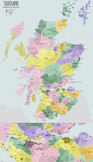
The shires of Scotland, or counties of Scotland, are historic subdivisions of Scotland established in the Middle Ages and used as administrative divisions until 1975. Originally established for judicial purposes, from the 17th century they started to be used for local administration purposes as well. The areas used for judicial functions (sheriffdoms) came to diverge from the shires, which ceased to be used for local government purposes after 1975 under the Local Government (Scotland) Act 1973.

<span class="mw-page-title-main">Burgh</span> Former autonomous corporate entity in Scotland and Northern England

A burgh is an autonomous municipal corporation in Scotland and Northern England, usually a city, town, or toun in Scots. This type of administrative division existed from the 12th century, when King David I created the first royal burghs. Burgh status was broadly analogous to borough status, found in the rest of the United Kingdom. Following local government reorganisation in 1975, the title of "royal burgh" remains in use in many towns, but now has little more than ceremonial value.

<span class="mw-page-title-main">Galashiels</span> Human settlement in Scotland

Galashiels is a town in the Scottish Borders with a population of around 12,600. Its name is often colloquially shortened to "Gala". The town is a major commercial centre for the Borders region with extensive history in the textile industry. Galashiels is the location of Heriot-Watt University's School of Textiles and Design.

<span class="mw-page-title-main">Peeblesshire</span> Historic county in Scotland

Peeblesshire, the County of Peebles or Tweeddale is a historic county of Scotland. Its county town is Peebles, and it borders Midlothian to the north, Selkirkshire to the east, Dumfriesshire to the south, and Lanarkshire to the west.

<span class="mw-page-title-main">Roxburghshire</span> Historic county in Scotland

Roxburghshire or the County of Roxburgh is a historic county and registration county in the Southern Uplands of Scotland. It borders Dumfriesshire to the west, Selkirkshire and Midlothian to the north-west, and Berwickshire to the north. To the south-west it borders Cumberland and to the south-east Northumberland, both in England.

<span class="mw-page-title-main">Selkirkshire</span> Historic county = in Scotland

Selkirkshire or the County of Selkirk is a historic county and registration county of Scotland. It borders Peeblesshire to the west, Midlothian to the north, Roxburghshire to the east, and Dumfriesshire to the south. It derives its name from its county town, the royal burgh of Selkirk. The county was historically also known as Ettrick Forest.

<span class="mw-page-title-main">Stirlingshire</span> Historic county in Scotland

Stirlingshire or the County of Stirling, Scottish Gaelic: Siorrachd Sruighlea) is a historic county and registration county of Scotland. Its county town is Stirling.

<span class="mw-page-title-main">Ettrick and Lauderdale</span> Former local government district in Scotland

Ettrick and Lauderdale was one of four local government districts in the Borders region of Scotland from 1975 to 1996.

Large burgh was a type of municipal structure in Scotland, which existed from 1930 to 1975.

A police burgh was a Scottish burgh which had adopted a "police system" for governing the town. They existed from 1833 to 1975.

<span class="mw-page-title-main">Local Government (Scotland) Act 1929</span> United Kingdom legislation

The Local Government (Scotland) Act 1929 reorganised local government in Scotland from 1930, introducing joint county councils, large and small burghs and district councils. The Act also abolished the Scottish poor law system with institutions passing to the local authorities.

Commissioners of Supply were local administrative bodies in Scotland from 1667 to 1930. Originally established in each sheriffdom to collect tax, they later took on much of the responsibility for the local government of the counties of Scotland. In 1890 they ceded most of their duties to the county councils created by the Local Government (Scotland) Act 1889. They were finally abolished in 1930.

<span class="mw-page-title-main">Motherwell (district)</span> Former local government district in Strathclyde, Scotland

L Motherwell was a local government district in the Strathclyde region of Scotland from 1975 to 1996, lying to the south-east of the regional capital Glasgow.

Local government areas covering the whole of Scotland were first defined by the Local Government (Scotland) Act 1889. As currently defined, they are a result, for the most part, of the Local Government etc (Scotland) Act 1994.

<span class="mw-page-title-main">County Buildings, Selkirk</span> Courthouse in Duns, Scotland

County Buildings is a municipal structure in Ettrick Terrace, Selkirk, Scottish Borders, Scotland. The complex, which was the headquarters of Selkirkshire County Council and was also used as a courthouse, is a Category B listed building.

References

  1. 1889 Act, sections 8 and 105.
  2. Guide to local government in parishes, counties and burghs. Edinburgh: Royal College of Physicians. 1892. pp. xxiii–xxx. Retrieved 31 December 2022.
  3. "Preparing for the elections in Scotland". The County Council Magazine. London: F. Warne and Company. 1890. p. 284. Retrieved 31 December 2021.
  4. Reid, John Alexander, ed. (1892). "February 23, 1892: The Corporation of the Burgh of Galashiels v. The Selkirk County Council, and John Steedman (Collector of County Rates)". The Poor Law Magazine and Local Government Journal. Edinburgh: James Turner and Company. p. 204. Retrieved 23 December 2022.
  5. Motherwell and Wishaw Burgh Order Confirmation Act 1920 (10 & 11 Geo. 5, c. xli)
  6. Law Reports: The Public General Statutes passed in the fifty-second and fifty-third years of the reign of Her Majesty Queen Victoria. London: William Clowes and Sons. 1889. p. 206. Retrieved 9 December 2022.
  7. Shennan, Hay (1892). Boundaries of Counties and Parishes in Scotland: as settled by the Boundary Commissioners under the Local Government (Scotland) Act, 1889. Edinburgh: William Green & Sons via Internet Archive.
  8. "Local Government (Scotland) Act 1929", legislation.gov.uk , The National Archives, 1929 c. 25, retrieved 23 December 2022