


This is a list of the most important fjords of the Russian Federation.
This is a list of the most important fjords of the Russian Federation.
In spite of the vastness of the Arctic coastlines of the Russian Federation there are relatively few fjords in Russia. Fjords are circumscribed to certain areas only; over thirty are in Novaya Zemlya —including lakes which are structurally fjords, with a few others in the Barents Sea coast of the Kola Peninsula, the Severnaya Zemlya archipelago, the Bering Sea coast of the Chukchi Peninsula [1] and the southeastern shores of Kamchatka. [2]

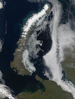
The Kara Sea is a marginal sea, separated from the Barents Sea to the west by the Kara Strait and Novaya Zemlya, and from the Laptev Sea to the east by the Severnaya Zemlya archipelago. Ultimately the Kara, Barents and Laptev Seas are all extensions of the Arctic Ocean north of Siberia. It is named after the Kara River, which is now relatively insignificant but which played an important role in the Russian conquest of northern Siberia. The Kara River name is derived from a Nenets word meaning "hummocked ice".

Severnaya Zemlya is a 37,000 km2 (14,000 sq mi) archipelago in the Russian high Arctic. It lies off Siberia's Taymyr Peninsula, separated from the mainland by the Vilkitsky Strait. This archipelago separates two marginal seas of the Arctic Ocean, the Kara Sea in the west and the Laptev Sea in the east.

October Revolution Island is the largest island of the Severnaya Zemlya group in the Russian Arctic. It is named after the October Revolution which led to Russia becoming a communist country.

Boris Andreyevich Vilkitsky was a Russian hydrographer and surveyor. He was the son of Andrey Ippolitovich Vilkitsky.

Bolshevik Island is an island in Severnaya Zemlya, Krasnoyarsk Krai, Russian Arctic. Bolshevik Island is named after the communist party Bolshevik (majority) also known as the party of Lenin.

Mikhail Andrianovich Lavrov (1799–1882) was a Russian rear-admiral and Arctic explorer.
Mityushikha Bay is a bay on Severny Island in Novaya Zemlya, Russia. Nuclear tests were conducted in 1961 in the area of the bay.

Vladimir Ivanovich Voronin was a Soviet Navy captain, born in Sumsky Posad, in the present Republic of Karelia, Russia. In 1932 he commanded the expedition of the Soviet icebreaker A. Sibiryakov which made the first successful crossing of the Northern Sea Route in a single navigation without wintering. This voyage was organized by the All-Union Arctic Institute.
Sukhoy Nos is a cape on Severny Island, the northern island of the archipelago Novaya Zemlya, projecting westward into the Barents Sea. The site lies near the southwestern corner of the island, 15 km (9.3 mi) from Mityushikha Bay, north of Matochkin Strait, which separates Severny from Yuzhny Island, the southern island of the archipelago.

Shokalsky Strait is a strait in Severnaya Zemlya, Russia.
Severny Island ice cap is an ice cap on Severny Island, northern island of the Novaya Zemlya archipelago in Russia. It covers 40% of Severny Island at total area of approximately 20,500 km2 (7,900 sq mi) which, if Novaya Zemlya is considered within Europe, makes it the largest glacier by area in Europe ahead of Vatnajökull at 8,100 km2 (3,100 sq mi), and Austfonna at 7,800 km2 (3,000 sq mi).

The Inostrantsev Glacier is one of the major glaciers in Novaya Zemlya, Arkhangelsk Oblast, Russia.
Cape Unslicht is a headland in Severnaya Zemlya, Russia.

Akhmatov Fjord, also known as Akhmatov Bay, is a fjord in Severnaya Zemlya, Krasnoyarsk Krai, Russia. This fjord is clogged by ice most of the year.

Mikoyan Bay is a bay in Severnaya Zemlya, Krasnoyarsk Krai, Russia. It is clogged by ice most of the year with many icebergs in the strait off the mouth of the bay.
Solnechny Bay, is a bay in Severnaya Zemlya, Krasnoyarsk Krai, Russia.
Krenkel Bay, is a bay in Severnaya Zemlya, Krasnoyarsk Krai, Russia.

Zhuravlev Bay, is a bay in Severnaya Zemlya, Krasnoyarsk Krai, Russia. This bay is blocked by ice most of the year.
Nordenskiöld Bay or Nordenskiöld Fjord is a fjord on the Barents Sea coast of Severny Island in Novaya Zemlya, Russia. The fjord is named after Arctic explorer Adolf Erik Nordenskiöld.