
Sedimentary rocks are types of rock that are formed by the accumulation or deposition of mineral or organic particles at Earth's surface, followed by cementation. Sedimentation is the collective name for processes that cause these particles to settle in place. The particles that form a sedimentary rock are called sediment, and may be composed of geological detritus (minerals) or biological detritus. The geological detritus originated from weathering and erosion of existing rocks, or from the solidification of molten lava blobs erupted by volcanoes. The geological detritus is transported to the place of deposition by water, wind, ice or mass movement, which are called agents of denudation. Biological detritus was formed by bodies and parts of dead aquatic organisms, as well as their fecal mass, suspended in water and slowly piling up on the floor of water bodies. Sedimentation may also occur as dissolved minerals precipitate from water solution.

Breccia is a rock composed of large angular broken fragments of minerals or rocks cemented together by a fine-grained matrix.

In geology, rock is any naturally occurring solid mass or aggregate of minerals or mineraloid matter. It is categorized by the minerals included, its chemical composition, and the way in which it is formed. Rocks form the Earth's outer solid layer, the crust, and most of its interior, except for the liquid outer core and pockets of magma in the asthenosphere. The study of rocks involves multiple subdisciplines of geology, including petrology and mineralogy. It may be limited to rocks found on Earth, or it may include planetary geology that studies the rocks of other celestial objects.

Petrology is the branch of geology that studies rocks and the conditions under which they form. Petrology has three subdivisions: igneous, metamorphic, and sedimentary petrology. Igneous and metamorphic petrology are commonly taught together because both make heavy use of chemistry, chemical methods, and phase diagrams. Sedimentary petrology is commonly taught together with stratigraphy because it deals with the processes that form sedimentary rock. Modern sedimentary petrology is making increasing use of chemistry.

The lithology of a rock unit is a description of its physical characteristics visible at outcrop, in hand or core samples, or with low magnification microscopy. Physical characteristics include colour, texture, grain size, and composition. Lithology may refer to either a detailed description of these characteristics, or a summary of the gross physical character of a rock. Examples of lithologies in the second sense include sandstone, slate, basalt, or limestone.
Lithostratigraphy is a sub-discipline of stratigraphy, the geological science associated with the study of strata or rock layers. Major focuses include geochronology, comparative geology, and petrology.
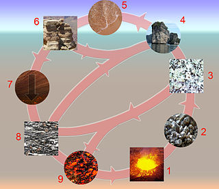
The rock cycle is a basic concept in geology that describes transitions through geologic time among the three main rock types: sedimentary, metamorphic, and igneous. Each rock type is altered when it is forced out of its equilibrium conditions. For example, an igneous rock such as basalt may break down and dissolve when exposed to the atmosphere, or melt as it is subducted under a continent. Due to the driving forces of the rock cycle, plate tectonics and the water cycle, rocks do not remain in equilibrium and change as they encounter new environments. The rock cycle explains how the three rock types are related to each other, and how processes change from one type to another over time. This cyclical aspect makes rock change a geologic cycle and, on planets containing life, a biogeochemical cycle.
Relative dating is the science of determining the relative order of past events, without necessarily determining their absolute age. In geology, rock or superficial deposits, fossils and lithologies can be used to correlate one stratigraphic column with another. Prior to the discovery of radiometric dating in the early 20th century, which provided a means of absolute dating, archaeologists and geologists used relative dating to determine ages of materials. Though relative dating can only determine the sequential order in which a series of events occurred, not when they occurred, it remains a useful technique. Relative dating by biostratigraphy is the preferred method in paleontology and is, in some respects, more accurate. The Law of Superposition, which states that older layers will be deeper in a site than more recent layers, was the summary outcome of 'relative dating' as observed in geology from the 17th century to the early 20th century.
Clastic rocks are composed of fragments, or clasts, of pre-existing minerals and rock. A clast is a fragment of geological detritus, chunks, and smaller grains of rock broken off other rocks by physical weathering. Geologists use the term clastic to refer to sedimentary rocks and particles in sediment transport, whether in suspension or as bed load, and in sediment deposits.

Earth Revealed: Introductory Geology, originally titled Earth Revealed, is a 26-part video instructional series covering the processes and properties of the physical Earth, with particular attention given to the scientific theories underlying geological principles. The telecourse was produced by Intelecom and the Southern California Consortium, was funded by the Annenberg/CPB Project, and first aired on PBS in 1992 with the title Earth Revealed. All 26 episodes are hosted by Dr. James L. Sadd, professor of environmental science at Occidental College in Los Angeles, California.
This glossary of geology is a list of definitions of terms and concepts relevant to geology, its sub-disciplines, and related fields. For other terms related to the Earth sciences, see Glossary of geography terms.

A geologist is a scientist who studies the solid, liquid, and gaseous matter that constitutes Earth and other terrestrial planets, as well as the processes that shape them. Geologists usually study geology, earth science, or geophysics, although backgrounds in physics, chemistry, biology, and other sciences are also useful. Field research is an important component of geology, although many subdisciplines incorporate laboratory and digitalized work. Geologists can be classified in a larger group of scientists, called geoscientists.
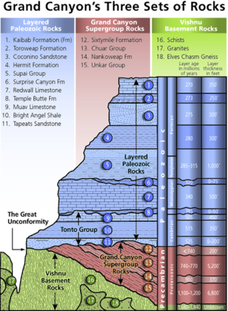
A stratigraphic column is a representation used in geology and its subfield of stratigraphy to describe the vertical location of rock units in a particular area. A typical stratigraphic column shows a sequence of sedimentary rocks, with the oldest rocks on the bottom and the youngest on top.

Igneous rock, or magmatic rock, is one of the three main rock types, the others being sedimentary and metamorphic. Igneous rocks are formed through the cooling and solidification of magma or lava.
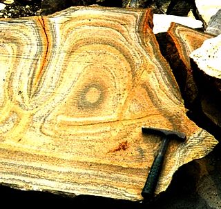
Liesegang rings are colored bands of cement observed in sedimentary rocks that typically cut across bedding. These secondary (diagenetic) sedimentary structures exhibit bands of (authigenic) minerals that are arranged in a regular repeating pattern. Liesegang rings are distinguishable from other sedimentary structures by their concentric or ring-like appearance. The precise mechanism from which Liesegang rings form is not entirely known and is still under research, but there is a precipitation process that is thought to be the catalyst for Liesegang ring formation, referred to as the Ostwald-Liesegang supersaturation-nucleation-depletion cycle. Though Liesegang rings are considered a frequent occurrence in sedimentary rocks, rings composed of iron oxide can also occur in permeable igneous and metamorphic rocks that have been chemically weathered.

Carbon Peak, elevation 12,088 ft (3,684 m), is a summit in the West Elk Mountains of Colorado. The peak is southwest of Crested Butte in the Gunnison National Forest. Carbon Peak is one of several prominent laccoliths found in the West Elk Mountains.
In geology and geomorphology a paleosurface is a surface made by erosion of considerable antiquity. Paleosurfaces might be flat or uneven in some cases having considerable relief. Flat and large paleosurfaces —that is planation surfaces— have higher potential to be preserved than small and irregular surfaces and are thus the most studied kind of paleosurfaces. Irregular paleosurfaces, albeit usually smaller than flat ones, occur across the globe, one example being the Sudetes etchsurfaces. In the case of peneplains it is argued that they become paleosurfaces once they are detached from the base level they grade to.
The geology of Northumberland National Park in northeast England includes a mix of sedimentary, intrusive and extrusive igneous rocks from the Palaeozoic and Cenozoic eras. Devonian age volcanic rocks and a granite pluton form the Cheviot massif. The geology of the rest of the national park is characterised largely by a thick sequence of sedimentary rocks of Carboniferous age. These are intruded by Permian dykes and sills, of which the Whin Sill makes a significant impact in the south of the park. Further dykes were intruded during the Palaeogene period. The whole is overlain by unconsolidated sediments from the last ice age and the post-glacial period.