List of islands of Argentina

Last updated

A map of Argentina Argentina-CIA WFB Map.png
A map of Argentina

The following are lists of islands that are part of, or claimed by, Argentina.

Contents

The list is divided into three parts. The first part is those islands that are not disputed. The second part is the Falkland Islands and South Georgia and the South Sandwich Islands, which are claimed by Argentina but are United Kingdom sovereign overseas territories (see Falkland Islands sovereignty dispute; South Georgia and the South Sandwich Islands sovereignty dispute).

The third part is the Argentine claim to Antarctica which overlaps both the British and Chilean Antarctic claims. All three countries are signatories to the Antarctic Treaty.

Undisputed

These are islands currently administered by Argentina

IslandProvinceCoordinates
Apipé, Isla Corrientes 27°30′S56°54′W / 27.500°S 56.900°W / -27.500; -56.900 (Apipé)
Apipé Chico, Isla Corrientes 27°34′S56°43′W / 27.567°S 56.717°W / -27.567; -56.717 (Apipé Chico)
Arce, Isla Chubut 45°00′S65°30′W / 45.000°S 65.500°W / -45.000; -65.500 (Arce)
Blancas, Islas Chubut 44°46′S65°39′W / 44.767°S 65.650°W / -44.767; -65.650 (Blancas)
Choele Choel Grande, Isla Río Negro 39°22′S65°43′W / 39.367°S 65.717°W / -39.367; -65.717 (Choele Choel Grande)
Costa Brava, Isla Corrientes 30°16′S59°39′W / 30.267°S 59.650°W / -30.267; -59.650 (Costa Brava)
Curuzú Chalí, Isla Entre Ríos 30°30′S59°37′W / 30.500°S 59.617°W / -30.500; -59.617 (Curuzú Chalí)
De Los Estados, Isla Tierra del Fuego 54°46′S64°18′W / 54.767°S 64.300°W / -54.767; -64.300 (De Los Estados)
Del Cerrito, Isla Chaco 27°19′S58°40′W / 27.317°S 58.667°W / -27.317; -58.667 (Del Cerrito)
Del Palo, Isla Buenos Aires 39°17′S62°14′W / 39.283°S 62.233°W / -39.283; -62.233 (Del Palo)
Del Paraguayo, Isla Entre Ríos 33°07′S60°28′W / 33.117°S 60.467°W / -33.117; -60.467 (Del Paraguayo)
Del Portugués, Isla Buenos Aires 34°01′S58°41′W / 34.017°S 58.683°W / -34.017; -58.683 (Del Portugués)
Entre Ríos, Isla Corrientes 27°26′S57°30′W / 27.433°S 57.500°W / -27.433; -57.500 (Entre Ríos)
Gable, Isla Tierra del Fuego 54°54′S67°32′W / 54.900°S 67.533°W / -54.900; -67.533 (Gable)
Grande De Tierra Del Fuego, Isla Tierra del Fuego 54°00′S68°00′W / 54.000°S 68.000°W / -54.000; -68.000 (Grande De Tierra Del Fuego)
Grande Del Río Chico, Isla Santa Cruz 49°12′S69°57′W / 49.200°S 69.950°W / -49.200; -69.950 (Grande Del Río Chico)
Grupo De La Isla Grande, Islas Misiones 25°30′S54°06′W / 25.500°S 54.100°W / -25.500; -54.100 (Grupo De La Isla Grande)
Lechiguanas, Islas Entre Ríos 33°26′S59°42′W / 33.433°S 59.700°W / -33.433; -59.700 (Lechiguanas)
Leones, Isla Chubut 45°02′S65°37′W / 45.033°S 65.617°W / -45.033; -65.617 (Leones)
Manuelín Cué, Isla Chaco 28°02′S58°52′W / 28.033°S 58.867°W / -28.033; -58.867 (Manuelín Cué)
Martín García, Isla Buenos Aires 34°11′S58°15′W / 34.183°S 58.250°W / -34.183; -58.250 (Martín García)
Observatorio, Isla Tierra del Fuego 54°39′S64°08′W / 54.650°S 64.133°W / -54.650; -64.133 (Observatorio)
Oyarbide, Isla Buenos Aires 34°12′S58°18′W / 34.200°S 58.300°W / -34.200; -58.300 (Oyarbide)
San Lucas Grande, Isla Misiones 28°10′S55°33′W / 28.167°S 55.550°W / -28.167; -55.550 (San Lucas Grande)
Solís, Islas Buenos Aires 34°12′S58°19′W / 34.200°S 58.317°W / -34.200; -58.317 (Solís)
Tova, Isla Chubut 45°07′S65°57′W / 45.117°S 65.950°W / -45.117; -65.950 (Tova)
Trinidad, Isla Buenos Aires 39°10′S61°57′W / 39.167°S 61.950°W / -39.167; -61.950 (Trinidad)
Victoria, Isla Neuquén 40°56′S71°33′W / 40.933°S 71.550°W / -40.933; -71.550 (Victoria)

Falkland Islands, and South Georgia and the South Sandwich Islands

The Falkland Islands and South Georgia and the South Sandwich Islands are United Kingdom sovereign territories claimed by Argentina.

Island (Spanish names)ProvinceCoordinates
Águila, Isla Falkland Islands 52°11′S59°42′W / 52.183°S 59.700°W / -52.183; -59.700 (Águila)
Annenkov, Isla South Georgia 54°27′S37°05′W / 54.450°S 37.083°W / -54.450; -37.083 (Annenkov)
Baja, Isla Falkland Islands 51°47′S61°07′W / 51.783°S 61.117°W / -51.783; -61.117 (Baja)
Beauchêne, Isla Falkland Islands 52°52′S59°12′W / 52.867°S 59.200°W / -52.867; -59.200 (Beauchêne)
Bellingshausen, Isla South Sandwich Islands 59°24′S26°58′W / 59.400°S 26.967°W / -59.400; -26.967 (Bellingshausen)
Blanco, Isla South Sandwich Islands 59°01′S26°30′W / 59.017°S 26.500°W / -59.017; -26.500 (Blanco)
Bougainville, Isla Falkland Islands 52°02′S58°30′W / 52.033°S 58.500°W / -52.033; -58.500 (Bougainville)
Calista, Isla Falkland Islands 52°01′S59°51′W / 52.017°S 59.850°W / -52.017; -59.850 (Calista)
Candelaria, Isla South Sandwich Islands 57°03′S26°42′W / 57.050°S 26.700°W / -57.050; -26.700 (Candelaria)
Candelaria, Islas South Sandwich Islands 57°04′S26°44′W / 57.067°S 26.733°W / -57.067; -26.733 (Candelaria)
Celebroña, Isla Falkland Islands 51°37′S57°45′W / 51.617°S 57.750°W / -51.617; -57.750 (Celebroña)
Cisne, Isla Falkland Islands 51°46′S59°35′W / 51.767°S 59.583°W / -51.767; -59.583 (Cisne)
Conejo, Isla Falkland Islands 51°33′S60°30′W / 51.550°S 60.500°W / -51.550; -60.500 (Conejo)
Cook, Isla South Sandwich Islands 59°26′S27°10′W / 59.433°S 27.167°W / -59.433; -27.167 (Cook)
Cooper, Isla South Georgia 54°48′S35°47′W / 54.800°S 35.783°W / -54.800; -35.783 (Cooper)
Cuarta, Isla Falkland Islands 51°32′S60°52′W / 51.533°S 60.867°W / -51.533; -60.867 (Cuarta)
Culebra, Isla Falkland Islands 51°08′S60°24′W / 51.133°S 60.400°W / -51.133; -60.400 (Culebra)
De Borbón, Isla Falkland Islands 51°18′S59°37′W / 51.300°S 59.617°W / -51.300; -59.617 (De Borbón)
De Goicoechea, Isla Falkland Islands 51°42′S61°17′W / 51.700°S 61.283°W / -51.700; -61.283 (De Goicoechea)
De Las Lechiguanas, Islas South Sandwich Islands 33°26′S59°42′W / 33.433°S 59.700°W / -33.433; -59.700 (De Las Lechiguanas)
De Los Arrecifes, Isla Falkland Islands 51°11′S60°53′W / 51.183°S 60.883°W / -51.183; -60.883 (De Los Arrecifes)
De Los Leones Marinos, Islas Falkland Islands 52°25′S59°00′W / 52.417°S 59.000°W / -52.417; -59.000 (De Los Leones Marinos)
Del Este, Isla Falkland Islands 51°22′S59°37′W / 51.367°S 59.617°W / -51.367; -59.617 (Del Este)
Del Este, Isla Falkland Islands 51°47′S58°05′W / 51.783°S 58.083°W / -51.783; -58.083 (Del Este)
Del Medio, Isla Falkland Islands 51°57′S58°29′W / 51.950°S 58.483°W / -51.950; -58.483 (Del Medio)
Del Pasaje, Islas Falkland Islands 51°35′S60°44′W / 51.583°S 60.733°W / -51.583; -60.733 (Del Pasaje)
Del Río, Isla Falkland Islands 51°24′S59°37′W / 51.400°S 59.617°W / -51.400; -59.617 (Del Río)
Del Rosario, Isla Falkland Islands 51°16′S60°35′W / 51.267°S 60.583°W / -51.267; -60.583 (Del Rosario)
Divisoria, Isla Falkland Islands 51°28′S60°43′W / 51.467°S 60.717°W / -51.467; -60.717 (Divisoria)
Dyke, Isla Falkland Islands 51°59′S60°53′W / 51.983°S 60.883°W / -51.983; -60.883 (Dyke)
Elefante, Isla Falkland Islands 51°53′S58°19′W / 51.883°S 58.317°W / -51.883; -58.317 (Elefante)
Georgias Del Sur, Islas South Georgia 54°00′S38°04′W / 54.000°S 38.067°W / -54.000; -38.067 (Georgias Del Sur)
Gobierno, Isla Falkland Islands 51°13′S59°55′W / 51.217°S 59.917°W / -51.217; -59.917 (Gobierno)
Gran Malvina, Isla Falkland Islands 51°48′S60°00′W / 51.800°S 60.000°W / -51.800; -60.000 (Gran Malvina)
Grande, Isla Falkland Islands 51°57′S59°42′W / 51.950°S 59.700°W / -51.950; -59.700 (Grande)
Grupo Tule Del Sur, Islas South Sandwich Islands 59°25′S27°12′W / 59.417°S 27.200°W / -59.417; -27.200 (Grupo Tule Del Sur)
Jorge, Isla Falkland Islands 52°19′S59°45′W / 52.317°S 59.750°W / -52.317; -59.750 (Jorge)
Jorge, Isla South Sandwich Islands 58°24′S26°20′W / 58.400°S 26.333°W / -58.400; -26.333 (Jorge)
León Marino Este, Isla Falkland Islands 52°25′S58°54′W / 52.417°S 58.900°W / -52.417; -58.900 (León Marino Este)
Leskov, Isla South Sandwich Islands 56°40′S28°09′W / 56.667°S 28.150°W / -56.667; -28.150 (Leskov)
Larga, Isla Falkland Islands 51°33′S58°05′W / 51.550°S 58.083°W / -51.550; -58.083 (Larga)
Las Llaves, Islas Falkland Islands 51°06′S60°49′W / 51.100°S 60.817°W / -51.100; -60.817 (Las Llaves)
León Marino, Isla Falkland Islands 51°55′S58°44′W / 51.917°S 58.733°W / -51.917; -58.733 (León Marino)
Los Hermanos, Isla Falkland Islands 51°09′S60°15′W / 51.150°S 60.250°W / -51.150; -60.250 (Los Hermanos)
Los Salvajes, Islas Falkland Islands 51°02′S61°09′W / 51.033°S 61.150°W / -51.033; -61.150 (Los Salvajes)
María, Isla Falkland Islands 52°12′S58°52′W / 52.200°S 58.867°W / -52.200; -58.867 (María)
Mayor, Isla Falkland Islands 52°08′S59°00′W / 52.133°S 59.000°W / -52.133; -59.000 (Mayor)
Montículo, Isla Falkland Islands 51°36′S60°27′W / 51.600°S 60.450°W / -51.600; -60.450 (Montículo)
Montura, Isla Falkland Islands 51°39′S61°14′W / 51.650°S 61.233°W / -51.650; -61.233 (Montura)
Morrell, Isla South Sandwich Islands 59°26′S27°19′W / 59.433°S 27.317°W / -59.433; -27.317 (Morrell)
Norte, Isla Falkland Islands 51°38′S61°13′W / 51.633°S 61.217°W / -51.633; -61.217 (Norte)
Oeste, Isla Falkland Islands 51°58′S59°50′W / 51.967°S 59.833°W / -51.967; -59.833 (Oeste)
Pájaro, Isla Falkland Islands 52°09′S60°55′W / 52.150°S 60.917°W / -52.150; -60.917 (Pájaro)
Pájaro, Isla South Georgia 54°00′S38°05′W / 54.000°S 38.083°W / -54.000; -38.083 (Pájaro)
Pájaros, Isla Falkland Islands 51°36′S57°47′W / 51.600°S 57.783°W / -51.600; -57.783 (Pájaros)
Pan De Azúcar, Isla Falkland Islands 51°09′S60°51′W / 51.150°S 60.850°W / -51.150; -60.850 (Pan De Azúcar)
Pelada, Isla Falkland Islands 52°21′S59°41′W / 52.350°S 59.683°W / -52.350; -59.683 (Pelada)
Pickersgill, Islas South Georgia 54°37′S36°45′W / 54.617°S 36.750°W / -54.617; -36.750 (Pickersgill)
Principal, Isla South Georgia 54°02′S38°16′W / 54.033°S 38.267°W / -54.033; -38.267 (Principal)
Principal, Isla Falkland Islands 52°25′S59°07′W / 52.417°S 59.117°W / -52.417; -59.117 (Principal)
Rasa, Isla Falkland Islands 51°15′S59°52′W / 51.250°S 59.867°W / -51.250; -59.867 (Rasa)
Rasa Del Oeste, Isla Falkland Islands 50°59′S61°26′W / 50.983°S 61.433°W / -50.983; -61.433 (Rasa Del Oeste)
Remolinos, Isla Falkland Islands 51°20′S60°42′W / 51.333°S 60.700°W / -51.333; -60.700 (Remolinos)
San José, Isla Falkland Islands 51°54′S61°00′W / 51.900°S 61.000°W / -51.900; -61.000 (San José)
San Julián, Isla Falkland Islands 51°38′S60°41′W / 51.633°S 60.683°W / -51.633; -60.683 (San Julián)
San Pedro, Isla South Georgia 54°00′S38°04′W / 54.000°S 38.067°W / -54.000; -38.067 (San Pedro)
San Rafael, Isla Falkland Islands 51°50′S61°16′W / 51.833°S 61.267°W / -51.833; -61.267 (San Rafael)
Sandwich Del Sur, Islas South Sandwich Islands 58°00′S27°00′W / 58.000°S 27.000°W / -58.000; -27.000 (Sandwich Del Sur)
Saunders, Isla South Sandwich Islands 57°48′S26°29′W / 57.800°S 26.483°W / -57.800; -26.483 (Saunders)
Sebaldes, Islas Falkland Islands 51°05′S61°11′W / 51.083°S 61.183°W / -51.083; -61.183 (Sebaldes)
Segunda, Isla Falkland Islands 51°34′S60°48′W / 51.567°S 60.800°W / -51.567; -60.800 (Segunda)
Soledad, Isla Falkland Islands 51°47′S58°48′W / 51.783°S 58.800°W / -51.783; -58.800 (Soledad)
Tercera, Isla Falkland Islands 51°33′S60°50′W / 51.550°S 60.833°W / -51.550; -60.833 (Tercera)
Traverse, Islas South Sandwich Islands 56°30′S27°20′W / 56.500°S 27.333°W / -56.500; -27.333 (Traverse)
Trinidad, Isla Falkland Islands 51°21′S60°09′W / 51.350°S 60.150°W / -51.350; -60.150 (Trinidad)
Trinidad, Isla South Georgia 54°00′S38°13′W / 54.000°S 38.217°W / -54.000; -38.217 (Trinidad)
Triste, Islas Falkland Islands 52°07′S58°44′W / 52.117°S 58.733°W / -52.117; -58.733 (Triste)
Tussac, Islas Falkland Islands 51°40′S57°44′W / 51.667°S 57.733°W / -51.667; -57.733 (Tussac)
Vigía, Isla Falkland Islands 51°19′S59°59′W / 51.317°S 59.983°W / -51.317; -59.983 (Vigía)
Vindicación, Isla South Sandwich Islands 57°05′S26°46′W / 57.083°S 26.767°W / -57.083; -26.767 (Vindicación)
Visokoi, Isla South Sandwich Islands 56°43′S27°13′W / 56.717°S 27.217°W / -56.717; -27.217 (Visokoi)
Zavodovski, Isla South Sandwich Islands 56°19′S27°36′W / 56.317°S 27.600°W / -56.317; -27.600 (Zavodovski)

Antarctica

Argentina's claim to Antarctica overlaps with the claims of Chile and the United Kingdom. All these claims are subject to the Antarctic Treaty and none have gained wide international recognition.

IslandProvinceCoordinates
Alejandro I, Isla Argentine Antarctica 71°00′S70°00′W / 71.000°S 70.000°W / -71.000; -70.000 (Alejandro I)
Amberes, Isla Argentine Antarctica 64°30′S63°30′W / 64.500°S 63.500°W / -64.500; -63.500 (Amberes)
Belgrano, Isla Argentine Antarctica 67°20′S68°40′W / 67.333°S 68.667°W / -67.333; -68.667 (Belgrano)
Berkner, Isla Argentine Antarctica 79°00′S49°30′W / 79.000°S 49.500°W / -79.000; -49.500 (Berkner)
Brabante, Isla Argentine Antarctica 64°20′S62°20′W / 64.333°S 62.333°W / -64.333; -62.333 (Brabante)
Clarence, Isla Argentine Antarctica 61°15′S53°55′W / 61.250°S 53.917°W / -61.250; -53.917 (Clarence)
Coronación, Islas Argentine Antarctica 60°37′S45°35′W / 60.617°S 45.583°W / -60.617; -45.583 (Coronación)
Decepción, Isla Argentine Antarctica 62°57′S60°38′W / 62.950°S 60.633°W / -62.950; -60.633 (Decepción)
Dolleman, Isla Argentine Antarctica 70°36′S60°48′W / 70.600°S 60.800°W / -70.600; -60.800 (Dolleman)
Dundee, Isla Argentine Antarctica 63°27′S56°05′W / 63.450°S 56.083°W / -63.450; -56.083 (Dundee)
Elefante, Isla Argentine Antarctica 61°10′S55°10′W / 61.167°S 55.167°W / -61.167; -55.167 (Elefante)
Hearst, Isla Argentine Antarctica 69°26′S62°08′W / 69.433°S 62.133°W / -69.433; -62.133 (Hearst)
Joinville, Isla Argentine Antarctica 63°15′S55°45′W / 63.250°S 55.750°W / -63.250; -55.750 (Joinville)
Latady, Isla Argentine Antarctica 70°40′S74°00′W / 70.667°S 74.000°W / -70.667; -74.000 (Latady)
Laurie, Isla Argentine Antarctica 60°45′S44°35′W / 60.750°S 44.583°W / -60.750; -44.583 (Laurie)
Orcadas Del Sur, Islas Argentine Antarctica 60°20′S46°00′W / 60.333°S 46.000°W / -60.333; -46.000 (Orcadas Del Sur)
Portillo, Isla Argentine Antarctica 78°46′S68°30′W / 78.767°S 68.500°W / -78.767; -68.500 (Portillo)
Quijada, Isla Argentine Antarctica 80°32′S61°30′W / 80.533°S 61.500°W / -80.533; -61.500 (Quijada)
Robertson, Isla Argentine Antarctica 65°10′S59°40′W / 65.167°S 59.667°W / -65.167; -59.667 (Robertson)
Ross, Isla Argentine Antarctica 64°10′S57°40′W / 64.167°S 57.667°W / -64.167; -57.667 (Ross)
Shetland Del Sur, Islas Argentine Antarctica 62°30′S60°00′W / 62.500°S 60.000°W / -62.500; -60.000 (Shetland Del Sur)
Steele, Isla Argentine Antarctica 71°00′S60°40′W / 71.000°S 60.667°W / -71.000; -60.667 (Steele)
25 De Mayo, Isla Argentine Antarctica 62°00′S58°15′W / 62.000°S 58.250°W / -62.000; -58.250 (25 De Mayo)

See also

Related Research Articles

<span class="mw-page-title-main">Antarctic Treaty System</span> International treaties concerning Antarctica

The Antarctic Treaty and related agreements, collectively known as the Antarctic Treaty System (ATS), regulate international relations with respect to Antarctica, Earth's only continent without a native human population. It was the first arms control agreement established during the Cold War, setting aside the continent as a scientific preserve, establishing freedom of scientific investigation, and banning military activity; for the purposes of the treaty system, Antarctica is defined as all the land and ice shelves south of 60°S latitude. Since September 2004, the Antarctic Treaty Secretariat, which implements the treaty system, is headquartered in Buenos Aires, Argentina.

<span class="mw-page-title-main">Antarctic</span> Polar region around Earths South Pole

The Antarctic is a polar region around Earth's South Pole, opposite the Arctic region around the North Pole. The Antarctic comprises the continent of Antarctica, the Kerguelen Plateau and other island territories located on the Antarctic Plate or south of the Antarctic Convergence. The Antarctic region includes the ice shelves, waters, and all the island territories in the Southern Ocean situated south of the Antarctic Convergence, a zone approximately 32 to 48 km wide varying in latitude seasonally. The region covers some 20 percent of the Southern Hemisphere, of which 5.5 percent is the surface area of the Antarctica continent itself. All of the land and ice shelves south of 60°S latitude are administered under the Antarctic Treaty System. Biogeographically, the Antarctic realm is one of eight biogeographic realms of Earth's land surface.

<span class="mw-page-title-main">South Georgia and the South Sandwich Islands</span> British Overseas Territory in the South Atlantic

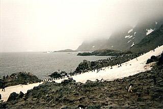
South Georgia and the South Sandwich Islands (SGSSI) is a British Overseas Territory in the southern Atlantic Ocean. It is a remote and inhospitable collection of islands, consisting of South Georgia and a chain of smaller islands known as the South Sandwich Islands. South Georgia is 165 kilometres (103 mi) long and 35 kilometres (22 mi) wide and is by far the largest island in the territory. The South Sandwich Islands lie about 700 kilometres (430 mi) southeast of South Georgia. The territory's total land area is 3,903 km2 (1,507 sq mi). The Falkland Islands are about 1,300 kilometres (810 mi) west from its nearest point.

<span class="mw-page-title-main">History of Antarctica</span> Past events regarding the continent of Antarctica

The history of Antarctica emerges from early Western theories of a vast continent, known as Terra Australis, believed to exist in the far south of the globe. The term Antarctic, referring to the opposite of the Arctic Circle, was coined by Marinus of Tyre in the 2nd century AD.

<span class="mw-page-title-main">British Antarctic Territory</span> British Overseas Territory

The British Antarctic Territory (BAT) is a sector of Antarctica claimed by the United Kingdom as one of its 14 British Overseas Territories, of which it is by far the largest by area. It comprises the region south of 60°S latitude and between longitudes 20°W and 80°W, forming a wedge shape that extends to the South Pole, overlapped by the Antarctic claims of Argentina and Chile.

<span class="mw-page-title-main">Tierra del Fuego Province, Argentina</span> Province in Ushuaia, Argentina

Tierra del Fuego, officially the Province of Tierra del Fuego, Antarctica and South Atlantic Islands, is the southernmost, smallest, and least populous Argentine province.

<span class="mw-page-title-main">Laurie Island</span> Island in Antarctica

Laurie Island is the second largest of the South Orkney Islands. The island is claimed by both Argentina as part of Argentine Antarctica, and the United Kingdom as part of the British Antarctic Territory. However, under the Antarctic Treaty System all sovereignty claims are frozen, as the island lies south of the parallel 60°. Buchanan Point at the north-eastern end of the island, with Cape Whitson on its south coast, are Important Bird Areas.

Sovereignty over the Falkland Islands is disputed by Argentina and the United Kingdom. The British claim to sovereignty dates from 1690, when they made the first recorded landing on the islands, and the United Kingdom has exercised de facto sovereignty over the archipelago almost continuously since 1833. Argentina has long disputed this claim, having been in control of the islands for a few years prior to 1833. The dispute escalated in 1982, when Argentina invaded the islands, precipitating the Falklands War.

<span class="mw-page-title-main">Chilean Antarctic Territory</span> Place in Magallanes y Antártica Chilena, Chile

The Chilean Antarctic Territory or Chilean Antarctica is the territory in Antarctica claimed by Chile. The Chilean Antarctic Territory ranges from 53° West to 90° West and from the South Pole to the 60° South parallel, partially overlapping the Argentine and British Antarctic claims. It is administered by the Cabo de Hornos municipality in the South American mainland.

<span class="mw-page-title-main">Falkland Islands Dependencies</span> Constitutional arrangement regarding the administration of various British dependencies

The Falkland Islands Dependencies was the constitutional arrangement from 1843 until 1985 for administering the various British territories in Sub-Antarctica and Antarctica which were governed from the Falkland Islands and its capital Port Stanley.

<span class="mw-page-title-main">Territorial claims in Antarctica</span> Land claims of the continent

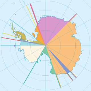
Seven sovereign states – Argentina, Australia, Chile, France, New Zealand, Norway, and the United Kingdom – have made eight territorial claims in Antarctica. These countries have tended to place their Antarctic scientific observation and study facilities within their respective claimed territories; however, a number of such facilities are located outside of the area claimed by their respective countries of operation, and countries without claims such as China, India, Italy, Japan, Pakistan, Russia, South Africa (SANAE), Ukraine, and the United States have constructed research facilities within the areas claimed by other countries. There are overlaps among the territories claimed by Argentina, Chile, and the United Kingdom.

<span class="mw-page-title-main">South Georgia and the South Sandwich Islands sovereignty dispute</span>

British sovereignty of South Georgia and the South Sandwich Islands is disputed by Argentina. The United Kingdom claimed South Georgia in 1775, annexed the islands in 1908, and has exercised de facto control with the exception of a brief period during the Falklands War in 1982, when the islands were partially controlled by Argentina. The dispute started in 1927 when Argentina claimed sovereignty over South Georgia, and subsequently expanded in scope with Argentina claiming the South Sandwich Islands in 1938. The islands have no indigenous population, and currently only have about 30 inhabitants.

<span class="mw-page-title-main">Tricontinental Chile</span> Geopolitical concept denoting Chiles unique position

Tricontinental Chile is a geopolitical concept denoting Chile's unique position with its mainland in South America, Easter Island in Oceania (Polynesia) and the Chilean Antarctic Territory in Antarctica.

<span class="mw-page-title-main">Argentine irredentism</span> Argentine claims over disputed territory

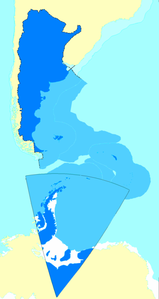
Argentine irredentism is the idea of Argentina's sovereignty over the British Overseas Territories of the Falkland Islands, South Georgia and the South Sandwich Islands, along with the dispute with Chile over the Southern Patagonian Ice Field and disputes with both over the region designated as Argentine Antarctica.

<span class="mw-page-title-main">Queen Elizabeth Land</span> Place in Antarctica

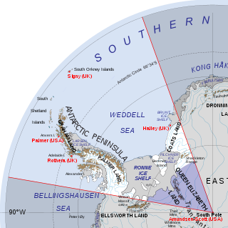
Queen Elizabeth Land is a portion of mainland Antarctica named by the government of the United Kingdom and claimed as part of the British Antarctic Territory. Situated south of Weddell Sea and between longitudes 20°W and 80°W, stretching from Filchner-Ronne Ice Shelf to the South Pole. It is bordered by Zumberge Coast of Ellsworth Land to the West and by Hercules Inlet to the Northwest. To the Northeast, circle of latitude 82°S is the dividing line against Coats Land. The area of Queen Elizabeth Land was unnamed until 2012, though most of it was unofficially known as Edith Ronne Land in 1947–68 and includes areas claimed by the United Kingdom, Chile and Argentina.

References

    Map all coordinates using: OpenStreetMap  
    Download coordinates as: KML