The list of lakes in Japan ranked by surface area.
1) For lakes in the Hokkaidō region, Subprefecture is listed

An island or isle is a piece of subcontinental land completely surrounded by water. Very small islands such as emergent land features on atolls can be called islets, skerries, cays or keys. An island in a river or a lake island may be called an eyot or ait, and a small island off the coast may be called a holm. Sedimentary islands in the Ganges Delta are called chars. A grouping of geographically or geologically related islands, such as the Philippines, is referred to as an archipelago.

This is a list of the lists of islands in the world grouped by country, by continent, by body of water, and by other classifications. For rank-order lists, see the other lists of islands below.
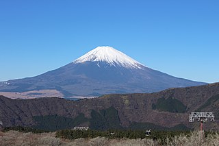
Mount Fuji is an active stratovolcano located on the Japanese island of Honshu, with a summit elevation of 3,776.24 m. It is the tallest mountain in Japan, the second-highest volcano located on an island in Asia, and seventh-highest peak of an island on Earth. Mount Fuji last erupted from 1707 to 1708. The mountain is located about 100 km (62 mi) southwest of Tokyo and is visible from the Japanese capital on clear days. Mount Fuji's exceptionally symmetrical cone, which is covered in snow for about five months of the year, is commonly used as a cultural icon of Japan and is frequently depicted in art and photography, as well as visited by sightseers, hikers and mountain climbers.

The Russian Far East is a region in Northeast Asia. It is the easternmost part of Russia and the Asian continent; and is administered as a part of the Far Eastern Federal District, which is located between Lake Baikal in eastern Siberia and the Pacific Ocean. The area's largest city is Khabarovsk, followed by Vladivostok. The region shares land borders with the countries of Mongolia, China, and North Korea to its south, as well as maritime boundaries with Japan to its southeast, and with the United States along the Bering Strait to its northeast.

The Kansai region or the Kinki region lies in the southern-central region of Japan's main island Honshū. The region includes the prefectures of Nara, Wakayama, Kyoto, Osaka, Hyōgo and Shiga, often also Mie, sometimes Fukui, Tokushima and Tottori. The metropolitan region of Osaka, Kobe and Kyoto is the second-most populated in Japan after the Greater Tokyo Area.

Shiga Prefecture is a landlocked prefecture of Japan located in the Kansai region of Honshu. Shiga Prefecture has a population of 1,412,916 and has a geographic area of 4,017 km2 (1,551 sq mi). Shiga Prefecture borders Fukui Prefecture to the north, Gifu Prefecture to the northeast, Mie Prefecture to the southeast, and Kyoto Prefecture to the west.

Shizuoka Prefecture is a prefecture of Japan located in the Chūbu region of Honshu. As of September 2023, Shizuoka Prefecture has a population of 3,555,818 and has a geographic area of 7,777.42 km2 (3,002.88 sq mi). Shizuoka Prefecture borders Kanagawa Prefecture to the east, Yamanashi Prefecture to the northeast, Nagano Prefecture to the north, and Aichi Prefecture to the west.
Ibaraki Prefecture is a prefecture of Japan located in the Kantō region of Honshu. Ibaraki Prefecture has a population of 2,828,086 and has a geographic area of 6,097.19 square kilometres. Ibaraki Prefecture borders Fukushima Prefecture to the north, Tochigi Prefecture to the northwest, Saitama Prefecture to the southwest, Chiba Prefecture to the south, and the Pacific Ocean to the east.
Tottori Prefecture is a prefecture of Japan located in the Chūgoku region of Honshu. Tottori Prefecture is the least populous prefecture of Japan at 538,525 (2023) and has a geographic area of 3,507.13 square kilometres (1,354.11 sq mi). Tottori Prefecture borders Shimane Prefecture to the west, Hiroshima Prefecture to the southwest, Okayama Prefecture to the south, and Hyōgo Prefecture to the east.

Towada is a city in Aomori Prefecture, Japan. As of 31 January 2023, the city had an estimated population of 58,905 in 28031 households, and a population density of 81 persons per km2 The total area of the city is 725.65 square kilometers (280.18 sq mi).Towada is home to the national and prefectural agencies that administer the Kamikita region, and is the central city of the region. In October 2012, the city signed an agreement with nine surrounding municipalities to improve the living environment, and has a cooperative relationship with Misawa City, which has an airport and a U.S. Air Force base.

Fuji-Hakone-Izu National Park is a national park in Yamanashi, Shizuoka, and Kanagawa Prefectures, and western Tokyo Metropolis, Japan. It consists of Mount Fuji, Fuji Five Lakes, Hakone, the Izu Peninsula, and the Izu Islands. Fuji-Hakone-Izu National Park covers 1,227 square kilometres (474 sq mi).

Hakone is a town in Kanagawa Prefecture, Japan. As of 1 October 2023, the town had a population of 10,965, and total area of 92.82 km2 (35.84 sq mi).

Lake Tazawa is a caldera lake in the city of Semboku, Akita Prefecture, northern Japan. It is the deepest lake in Japan at 423 metres (1,388 ft). The area is a popular vacation area and several hot spring resorts can be found in the hills above the lake. Akita Prefecture's largest ski area, Tazawako Ski Area [ja], overlooks the lake.

Lake Shikotsu is a caldera lake in Chitose, Hokkaidō, Japan. It is a part of the Shikotsu-Toya National Park.

Lake Ikeda is a caldera lake located 40 km (25 mi) south of Kagoshima city; Kyūshū island, Japan. It is perhaps best known to tourists as the location of the purported sightings of a monster named Issie, and as the largest lake on Kyūshū island with a surface area of 11 km2 (4.2 sq mi) and a shoreline length of 15 km (9.3 mi).
National Route 103 is a national highway of Japan connecting the capital of Aomori Prefecture, Aomori to Ōdate in northeastern Akita Prefecture. It has a total length of 130.0 km (80.8 mi).

Abashiri Quasi-National Park is a quasi-national park in Japan. The park protects the waters and surrounding coastline of the lakes and lagoons along the Sea of Okhotsk on Hokkaidō. This includes such lakes as Lake Abashiri and Lake Notoro as well as Lake Tōfutsu and Lake Saroma. Lake Saroma is the fourth largest lake in Japan. Most of the park lies within the limits of Abashiri in Abashiri Subprefecture of northeastern Hokkaidō.

The Auburn Botanic Gardens are a botanical garden located in Auburn, New South Wales, Australia. It was established in 1977 and covers an area of 9.7 hectares. There are two lakes, a waterfall and bridges. Duck River winds through the garden. The garden is maintained by Cumberland Council. It is open daily, and there is a small entry fee on weekends. The Japanese gardens, which have hosted couples from overseas, are one of the main attractions.
The following index is provided as an overview of and topical guide to Wikipedia's articles on recreational dive sites. The level of coverage may vary: