Related Research Articles

Oceanography, also known as oceanology, is the scientific study of the ocean. It is an important Earth science, which covers a wide range of topics, including ecosystem dynamics; ocean currents, waves, and geophysical fluid dynamics; plate tectonics and the geology of the sea floor; and fluxes of various chemical substances and physical properties within the ocean and across its boundaries. These diverse topics reflect multiple disciplines that oceanographers utilize to glean further knowledge of the world ocean, including astronomy, biology, chemistry, climatology, geography, geology, hydrology, meteorology and physics. Paleoceanography studies the history of the oceans in the geologic past. An oceanographer is a person who studies many matters concerned with oceans including marine geology, physics, chemistry and biology.

Numerical climate models use quantitative methods to simulate the interactions of the important drivers of climate, including atmosphere, oceans, land surface and ice. They are used for a variety of purposes from study of the dynamics of the climate system to projections of future climate. Climate models may also be qualitative models and also narratives, largely descriptive, of possible futures.

A general circulation model (GCM) is a type of climate model. It employs a mathematical model of the general circulation of a planetary atmosphere or ocean. It uses the Navier–Stokes equations on a rotating sphere with thermodynamic terms for various energy sources. These equations are the basis for computer programs used to simulate the Earth's atmosphere or oceans. Atmospheric and oceanic GCMs are key components along with sea ice and land-surface components.

Physical oceanography is the study of physical conditions and physical processes within the ocean, especially the motions and physical properties of ocean waters.
Thermohaline circulation (THC) is a part of the large-scale ocean circulation that is driven by global density gradients created by surface heat and freshwater fluxes. The adjective thermohaline derives from thermo- referring to temperature and -haline referring to salt content, factors which together determine the density of sea water. Wind-driven surface currents travel polewards from the equatorial Atlantic Ocean, cooling en route, and eventually sinking at high latitudes. This dense water then flows into the ocean basins. While the bulk of it upwells in the Southern Ocean, the oldest waters upwell in the North Pacific. Extensive mixing therefore takes place between the ocean basins, reducing differences between them and making the Earth's oceans a global system. The water in these circuits transport both energy and mass around the globe. As such, the state of the circulation has a large impact on the climate of the Earth.

A continental shelf is a portion of a continent that is submerged under an area of relatively shallow water known as a shelf sea. Much of these shelves were exposed by drops in sea level during glacial periods. The shelf surrounding an island is known as an insular shelf.

A tropical wave, in and around the Atlantic Ocean, is a type of atmospheric trough, an elongated area of relatively low air pressure, oriented north to south, which moves from east to west across the tropics, causing areas of cloudiness and thunderstorms. Tropical waves form in the easterly flow along the equator-ward side of the subtropical ridge or belt of high air pressure which lies north and south of the Intertropical Convergence Zone (ITCZ). Tropical waves are generally carried westward by the prevailing easterly winds along the tropics and subtropics near the equator. They can lead to the formation of tropical cyclones in the north Atlantic and northeastern Pacific basins. A tropical wave study is aided by Hovmöller diagrams, a graph of meteorological data.

In oceanic biogeochemistry, the solubility pump is a physico-chemical process that transports carbon as dissolved inorganic carbon (DIC) from the ocean's surface to its interior.
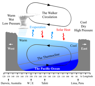
The Walker circulation, also known as the Walker cell, is a conceptual model of the air flow in the tropics in the lower atmosphere (troposphere). According to this model, parcels of air follow a closed circulation in the zonal and vertical directions. This circulation, which is roughly consistent with observations, is caused by differences in heat distribution between ocean and land. It was discovered by Gilbert Walker. In addition to motions in the zonal and vertical direction the tropical atmosphere also has considerable motion in the meridional direction as part of, for example, the Hadley Circulation.
Paleoceanography is the study of the history of the oceans in the geologic past with regard to circulation, chemistry, biology, geology and patterns of sedimentation and biological productivity. Paleoceanographic studies using environment models and different proxies enable the scientific community to assess the role of the oceanic processes in the global climate by the re-construction of past climate at various intervals. Paleoceanographic research is also intimately tied to paleoclimatology.
The Thermohaline Circulation is a pattern of water flow through the world's oceans. Warm water flows along the surface until it reaches one of a few special spots near Greenland or Antarctica. There, the water sinks, and then crawls across the bottom of the ocean, miles/kilometers deep, over hundreds of years, gradually rising in the Pacific and Indian oceans.

The Atlantic meridional overturning circulation (AMOC) is the zonally integrated component of surface and deep currents in the Atlantic Ocean. It is characterized by a northward flow of warm, salty water in the upper layers of the Atlantic, and a southward flow of colder, deep waters that are part of the thermohaline circulation. These "limbs" are linked by regions of overturning in the Nordic and Labrador Seas and the Southern Ocean. The AMOC is an important component of the Earth's climate system, and is a result of both atmospheric and thermohaline drivers.
The following outline is provided as an overview of and introduction to Oceanography.
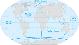
The ocean is the body of salt water which covers approximately 71% of the surface of the Earth and contains 97% of Earth's water. Another definition is "any of the large bodies of water into which the great ocean is divided". Separate names are used to identify five different areas of the ocean: Pacific Atlantic, Indian, Southern (Antarctic), and Arctic. Seawater covers approximately 361,000,000 km2 (139,000,000 sq mi) of the planet. The ocean is the principal component of Earth's hydrosphere, and therefore integral to life on Earth. Acting as a huge heat reservoir, the ocean influences climate and weather patterns, the carbon cycle, and the water cycle.
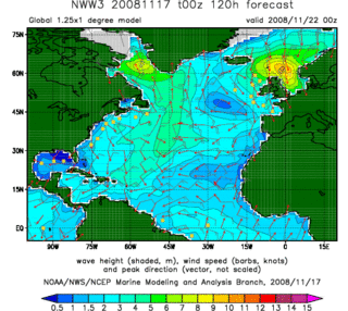
In fluid dynamics, wind wave modeling describes the effort to depict the sea state and predict the evolution of the energy of wind waves using numerical techniques. These simulations consider atmospheric wind forcing, nonlinear wave interactions, and frictional dissipation, and they output statistics describing wave heights, periods, and propagation directions for regional seas or global oceans. Such wave hindcasts and wave forecasts are extremely important for commercial interests on the high seas. For example, the shipping industry requires guidance for operational planning and tactical seakeeping purposes.
Regional Ocean Modeling System (ROMS) is a free-surface, terrain-following, primitive equations ocean model widely used by the scientific community for a diverse range of applications. The model is developed and supported by researchers at the Rutgers University, University of California Los Angeles and contributors worldwide.
Ocean general circulation models (OGCMs) are a particular kind of general circulation model to describe physical and thermodynamical processes in oceans. The oceanic general circulation is defined as the horizontal space scale and time scale larger than mesoscale. They depict oceans using a three-dimensional grid that include active thermodynamics and hence are most directly applicable to climate studies. They are the most advanced tools currently available for simulating the response of the global ocean system to increasing greenhouse gas concentrations. A hierarchy of OGCMs have been developed that include varying degrees of spatial coverage, resolution, geographical realism, process detail, etc.
The Model for Prediction Across Scales (MPAS) is a coupled Earth system modeling package that integrates atmospheric, oceanographic and cryospheric modeling on a variety of scales from the planetary to regional and mesoscale/microscale. It includes climate and weather modeling and simulations that were first used by researchers in 2013. The atmospheric components (MPAS-A) were led by the National Center for Atmospheric Research (NCAR)'s Earth System Laboratory (NESL) and the oceanographic components (MPAS-O) by the Climate, Ocean, and Sea Ice Modeling Group (COSIM) at Los Alamos National Laboratory (LANL). It has been used for real-time weather as well as seasonal forecasting of convection, tornadoes and tropical cyclones, among other uses. Its atmospheric modeling aspects are intended to use and complement rather than replace the Weather Research and Forecasting Model (WRF-ARW/NMM), the Global Forecast System (GFS) and the Community Earth System Model (CESM).
Paola Malanotte Rizzoli is a physical oceanographer known for her research on ocean circulation and sea level rise, especially with respect to flooding conditions in Venice.
The Hybrid Coordinate Ocean Model (HyCOM) is an open-source ocean general circulation modeling system. HyCOM is a primitive equation type of ocean general circulation model. The vertical levels of this modeling system are slightly different than other models, because the vertical coordinates remain isopycnic in the open stratified ocean, smoothly transitioning to z-level coordinates in the weakly stratified upper-ocean mixed layer, to terrain-following sigma coordinates in shallow water regions, and back to z-level coordinates in very shallow water. Therefore, the setup is a “hybrid” between z-level and terrain-following vertical levels. HyCOM outputs are provided online for the global ocean at a spatial resolution of 0.08 degrees from 2003 to present. HyCOM uses netCDF data format for model outputs.
References
- ↑ Wolff J-O, Maier-Reimer E, Legutke S (1997) The Hamburg Ocean Primitive Equation Model HOPE. DKRZ report 13, Hamburg, Germany, doi : 10.2312/WDCC/DKRZ_Report_No13.
- ↑ Maier-Reimer E, Mikolajewicz U (1992) The Hamburg Large Scale Geostrophic Ocean General Circulation Model (Cycle 1). DKRZ report 2, Hamburg, Germany, doi : 10.2312/WDCC/DKRZ_Report_No02.
- ↑ Oberhuber JM (1993) Simulation of the Atlantic circulation with a coupled sea ice-mixed layer-isopycnal general circulation model, part I: model description. Journal of Physical Oceanography, 23, 808–829 doi : 10.1175/1520-0485(1993)023<0808:SOTACW>2.0.CO;2.
- ↑ Oberhuber JM (1993) The OPYC Ocean General Circulation Model. DKRZ report 7, Hamburg, Germany, doi : 10.2312/WDCC/DKRZ_Report_No07.
- ↑ "Versatile Ocean Simulator in Pure Python — documentation". veros.readthedocs.io. Retrieved 2021-09-10.
- ↑ Warner, John C.; Armstrong, Brandy; He, Ruoying; Zambon, Joseph B. (2010). "Development of a Coupled Ocean–Atmosphere–Wave–Sediment Transport (COAWST) Modeling System". Ocean Modelling. 35 (3): 230–244. Bibcode:2010OcMod..35..230W. doi:10.1016/j.ocemod.2010.07.010. hdl: 1912/4099 . ISSN 1463-5003.
- ↑ "COAWST". coawstmodel-trac.sourcerepo.com. Retrieved 2019-02-08.
- ↑ Wilkin, John; Zavala-Garay, Javier; Levin, Julia. "Integrating modeling and data assimilation using ROMS with a Coastal Ocean Observing System for the US Middle Atlantic Bight" (PDF). Workshop Report: The Australian Coastal and Oceans Modelling and Observations Workshop (ACOMO 2012). p. 3. Retrieved 2016-10-25.
- ↑ "ESPRESSO ocean modeling from Rutgers ROMS group". www.myroms.org. Retrieved 2019-02-08.