The New Zealand state highway network is the major national highway network in New Zealand. Nearly 100 roads in the North and South Islands are state highways. All state highways are administered by the NZ Transport Agency.

The national highways in India are a network of trunk roads owned by the Ministry of Road Transport and Highways. National highways have flyover access or some controlled-access, where entrance and exit is through the side of the flyover. At each highway intersection, flyovers are provided to bypass the traffic on the city, town, or village. These highways are designed for speeds of 100 km/h. Some national highways have interchanges in between, but do not have total controlled-access throughout the highways. The highways are constructed and managed by the Central Public Works Department (CPWD), the National Highways and Infrastructure Development Corporation Limited (NHIDCL), and the public works departments (PWD) of state governments. Currently, the longest national highway in India is National Highway 44 at 4,112 km. India started four laning of major national highways with the National Highway Development Project (NHDP). As of March 2022 India has approximately 35,000 km of four laned National highways.

The China National Highways (CNH/Guodao) is a network of trunk roads across mainland China. Apart from the expressways of China that are planned and constructed later, most of the CNH are not controlled-access highways.

Bayawan, officially the City of Bayawan, is a 1st class component city in the province of Negros Oriental, Philippines. According to the 2020 census, it has a population of 122,747 people.
A routenumber, designation or abbreviation is an identifying numeric designation assigned by a highway authority to a particular stretch of roadway to distinguish it from other routes and, in many cases, also to indicate its classification, general geographical location and/or orientation. The numbers chosen may be used solely for internal administrative purposes; however, in most cases they are also displayed on roadside signage and indicated on maps.

The expressways of Japan make up a large network of controlled-access toll expressways.

Cauayan, officially the City of Cauayan, is a 2nd class component city in the province of Isabela, Philippines. According to the 2020 census, it has a population of 143,403 people.

Khotang District is one of 14 districts of Koshi Province of eastern Nepal. The district, with Diktel as its district headquarters, covers an area of 1,591 km2 (614 sq mi) and has a population (2021) of 206,312. The district is bordered by Bhojpur District in the east, Udayapur District in the south, Okhaldhunga District in the west and Solukhumbu District in the North. In this district there are two municipalities and eight rural/urban municipalities.

Roads in India are an important mode of transport in India. India has a network of over 6,331,791 kilometres (3,934,393 mi) of roads. This is the second-largest road network in the world, after the United States. At of roads per square kilometre of land, the quantitative density of India's road network is equal to that of Hong Kong, and substantially higher than the United States, China, Brazil and Russia. Adjusted for its large population, India has approximately 5.13 kilometres (3.19 mi) of roads per 1,000 people, which is much lower than United States 20.5 kilometres (12.7 mi) but higher than that of China 3.6 kilometres (2.2 mi). India's road network carries over 71% of its freight and about 85% of passenger traffic.

Saskatchewan, the middle of Canada's three prairie provinces, has an area of 588,276.09 square kilometres (227,134.67 sq mi) and population of 1,150,632, mostly living in the southern half of the province.

Serei Saophoan is a municipality (krong) in the centre of Banteay Meanchey province, in north-western Cambodia. Serei Saophoan is the urban district of Banteay Meanchey province and the district capital is also the provincial capital Sisophon town. The town is located 359 kilometres north of Phnom Penh and 48 kilometres from the border with Thailand at Poipet. Serei Saophoan municipality is the central municipality of Banteay Meanchey and is surrounded by other Banteay Meanchey districts. Cambodia's main railway line from Phnom Penh to Poipet enters the municipality from the south and exits to the west.

The Ministry of Highways is divided into the Operations, Policy and Programs, and Corporate Services Divisions and the Communications Branch. The ministry is the employer of over 1,476 employees diversified amongst 105 communities in Saskatchewan. The current Minister of Highways and Infrastructure is Jeremy Cockrill.
This article describes the highway systems available in selected countries.

Bagmati Province is one of the seven provinces of Nepal established by the constitution of Nepal. Bagmati is Nepal's second-most populous province and fifth largest province by area. It is bordered by Tibet Autonomous Region of China to the north, Gandaki Province to the west, Koshi Province to the east, Madhesh Province and the Indian state of Bihar to the south. With Hetauda as its provincial headquarters, the province is also the home to the country's capital Kathmandu, is mostly hilly and mountainous, and hosts mountain peaks including Gaurishankar, Langtang, Jugal, and Ganesh.
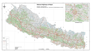
The National Highway System of Nepal is the group of main roads in Nepal. Any highway or road that connects east to west and north to south is considered a National Highway of Nepal.

NH04 or Birtamod-Bhadrapur road is a short National Highway of Nepal, located in Jhapa District of Koshi Province. The total length of the highway is just 12.53 kilometres (7.79 mi). The road is fully black topped four lane National Highway.


